Description:
Boston: Geo. W. Stadly, 1899. Hardcover. Very Good. Large folio, 21" x 16 1/2". 12 maps of Hyde Park, all double page and colored. A few small marks and occasional thumb marks in the margins, but generally bright and quite attractive with no tears. Incorporated into the City of Boston in 1912 to become the southernmost neighborhood in the city, Hyde Park at this point was a separate city and the northernmost town in Norfolk County. Brown cloth spine and corners over embossed cloth boards - heavily worn at corners, well through to the boards - binding shows relatively modest wear and rubbing otherwise. Binding tight, boards a little bowed. At the time an industrial town situated at the confluence of the Neponset and the Mother Brook and connected to Boston by Hyde Park Avenue. It was home to the 54th Massachusetts Volunteer Infantry (the "Glory" division). Just one copy in OCLC at the Boston Public Library. Size: Elephant folio. Quantity Available: 1. Shipped Weight: 2-3 kilos. Category: Countries &…
Read More Devonshire with Excester Described by SPEED, John - 1623
by SPEED, John
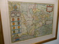
Devonshire with Excester Described
by SPEED, John
- Used
- near fine
John Sudbury & George Humble, 1623. English Text Edition. Map. Near Fine. 505 x 380mm. A early edition of Speed's map of Devon. Fabulous later full wash hand colouring. A couple of minor paper flaws add character to this wonderful map which is nearly four hundred years old. Framed and double-glazed to show text on verso, in a lovely antique gold style frame. Batten & Bennett, 6.4. [it may not be possible to post this item in it's frame].
-
Bookseller
Independent bookstores
 (GB)
(GB)
- Format/Binding Map
- Book Condition Used - Near Fine
- Quantity Available 1
- Edition English Text Edition
- Publisher John Sudbury & George Humble
- Date Published 1623
- Keywords Devon Maps.catx91, Devon. Speed Maps. Antique Maps.
- Size 505 x 380mm

More Photos
Atlas of the Town of Hyde Park Norfolk County, Mass. From Official Plans and Actual Surveys
by Anon
- Used
- very good
- Hardcover
- Condition
- Used - Very Good
- Binding
- Hardcover
- Quantity Available
- 1
- Seller
-
Roslindale, Massachusetts, United States
- Item Price
-
NZ$1,290.75
Show Details
Item Price
NZ$1,290.75
More Photos
Mapping the Transmississippi West [1995, 6 separate vols, complete; with large FOLD-OUT maps; new, in publisher's shrinkwrap & PUBLISHER'S CARDBOARD SHIPPING BOX
by Wheat, Carl I.
- New
- Hardcover
- first
- Condition
- New
- Jacket Condition
- in publisher's shrinkwrap
- Edition
- First Martino/About Books printing
- Binding
- Hardcover
- Quantity Available
- 1
- Seller
-
Henderson, Nevada, United States
- Item Price
-
NZ$1,114.35
Show Details
Description:
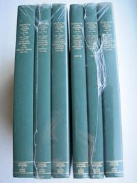
Storrs-Mansfield, CT / Parsippany, New Jersey: Martino Fine Books / About Books, 1995. 6 separate volumes, complete [5 volumes bound in 6 books WITH LARGE FOLD-OUT MAPS -- just like the first edition]. SEE PHOTOS. Each of the 6 books in this 1995 large format edition measures 9.25" wide by 12.25" tall. [This is NOT the later, smaller format 3-volume reprint in which the maps are reduced in size]. Unlike later reduced-size editions, the maps in this 1995 six-volume edition measure as large as 21" by 33" when unfolded. SEE PHOTOS. As original co-publisher, we are pleased to offer the few remaining sets of the 1995 large-format 6-volume edition (recently rediscovered in our warehouse). They are BRAND NEW in perfect condition. STILL SEALED in the publisher's clear plastic SHRINKWRAP and the PUBLISHER'S CARDBOARD SHIPPING BOX. NO rubbing. NO fading. Bright, clean, square and tight. NO owner's name or bookplate. NOT a remainder. Fresh and crisp -- obviously…
Read More Item Price
NZ$1,114.35

More Photos
Méthode simple et facile pour lever les plans, suivie d'un traité du nivellement, d'un abrégé des règles du lavis et des élémens de trigonométrie rectiligne
by LECOY, François
- Used
- near fine
- Hardcover
- Condition
- Used - Near Fine
- Edition
- First
- Binding
- Hardcover
- Quantity Available
- 1
- Seller
-
COLUMBIA, Missouri, United States
- Item Price
-
NZ$1,030.88
Show Details
Description:
1805 Surveying Method Topography COLOR Map Making Landscaping Construction LecoyFrancois Lecoy's 'Simple and Easy Methods for Surveying' is a fine, early 19th-century treatise on the systems used in construction and map preparation. Lecoy discusses the means by which French surveyors level land through the means of linear trigonometry. This 1805 first edition is an exception example of early 19th-century landscaping and topography. Note that this book includes impressive, folding color engravings of topographical examples and surveying tools.
Item number: #11652
Price: $599
LECOY, François
Méthode simple et facile pour lever les plans, suivie d'un traité du nivellement, d'un abrégé des règles du lavis et des élémens de trigonométrie rectiligne
A Paris : Chez Duponcet ..., an XIII=1805. First edition.
Details:
·
Collation: Complete with all pages
o xxxii, 119, [1], 12
o 12 folding plates
·
Provenance: Handwritten – Duponcet
o Signed by the publisher
·… Read More
Item Price
NZ$1,030.88

More Photos
Traité de la géographie moderne
by GIBRAT, Jean Baptiste
- Used
- near fine
- Hardcover
- Condition
- Used - Near Fine
- Binding
- Hardcover
- Quantity Available
- 1
- Seller
-
COLUMBIA, Missouri, United States
- Item Price
-
NZ$1,290.75
Show Details
Description:
1789 Atlas MAPS Gibrat Geography USA Italy Turkey Louisiana Mexico AmericaA rare 18th-century geographical treatise by Jean Baptiste Gibrat. Little is known of Gibrat other than this work; however, this work is a fine study in geography. Per the title, this work was designed for use of college and university students and includes descriptions of France, Switzerland, Greece, Turkey, Spain, Italy, and even America and Mexico!
Item number: #14739
Price: $750
GIBRAT, Jean Baptiste
Traité de la géographie moderne
A Toulouse, J. Robert ainé, 1789.
Details:
· Collation: Complete with all pages
o
xlviii, 412 (i.e. 456)
o 19 engraved plates
· Language: French
· Binding: Leather; tight & secure
· Size: ~6.75in X 4in (17cm x 10cm)
Our Guarantee:
Very Fast. Very Safe. Free Shipping Worldwide.
Customer satisfaction is our priority! Notify us with 7 days of receiving, and we will offer a full refund without reservation!
14739Photos available upon request.
Item Price
NZ$1,290.75

More Photos
Gall and Inglis’ School Atlas of Modern Geography
by Gall and Inglis
- Used
- near fine
- Hardcover
- Condition
- Used - Near Fine
- Binding
- Hardcover
- Quantity Available
- 1
- Seller
-
COLUMBIA, Missouri, United States
- Item Price
-
NZ$1,290.75
Show Details
Description:
1861 RARE Gall Inglis ATLAS Geography China America Australia 31 COLOR MAPSGall and Inglis' "School Atlas of Modern Geography" is a civil war compilation of 31 royal quarto maps. This 1861 edition includes maps of Europe, England and Wales, Ireland, Scotland, North America, South America, Switzerland, Turkey, Hindostan, and much more!
Item number: #13467
Price: $750
Gall and Inglis
Gall and Inglis' School Atlas of Modern Geography
Edinburgh: Gall & Inglis, 1861.
Details:
·
Collation: Complete with all pages
o 31 color maps
· Language: English
· Binding: Hardcover; tight & secure
o
Cloth
· Size: ~12.5in X 9.75in (31.5cm x 25cm)
Our Guarantee:
Very Fast. Very Safe. Free Shipping Worldwide.
Customer satisfaction is our priority! Notify us with 7 days of receiving, and we will offer a full refund without reservation!
13467Photos available upon request.
Item Price
NZ$1,290.75

More Photos
Histoire des révolutions de Perse depuis le commencement de ce siècle jusqu'à la fin du règne de l'usurpateur Aszraff.
by CERCEAU, Jean-Antoine du [attributed]
- Used
- near fine
- Hardcover
- Condition
- Used - Near Fine
- Binding
- Hardcover
- Quantity Available
- 1
- Seller
-
COLUMBIA, Missouri, United States
- Item Price
-
NZ$1,030.88
Show Details
Description:
1742 History of PERSIA Revolutions Nader Shah Kouli Khan Iran MAP Middle East 2vJean-Antoine du Cerceau was a 17th-century French Jesuit poet whose works were quite popular amongst noble courts. He is best known for his poems, plays, and short stories, but he also wrote an important work on the history of the Persian revolutions and the reign of Qoli Khan, the Nader Shah. This work, which is also sometimes attributed to Andre Claustre, covers the history of Iran, Afghanistan, and Persia, religious and cultural customs, and Middle Eastern geography.
This book also discusses the reign of Qoli Khan himself, his corrupt power, and the revolts and assassination against him. Note the impressive folding map.
Item number: #12308
Price: $599
CERCEAU, Jean-Antoine du [attributed]
Histoire des révolutions de Perse depuis le commencement de ce siècle jusqu'à la fin du règne de l'usurpateur Aszraff.
Paris : Briasson, 1742.
Details:
·
Collation: Complete with all pages; 2 volumes
o
Vol. 1 –… Read More
Item Price
NZ$1,030.88
More Photos
Napa County California. 1914
by Copyright 1914 by Punnett Brothers
- Used
- Condition
- Used
- Quantity Available
- 1
- Seller
-
FRAMINGHAM, Massachusetts, United States
- Item Price
-
NZ$1,634.95
Show Details
Description:
Map Details and Condition:color lithograph
dimensions: 26 3/4" x 19"
Brown Paper pocket covers with red bookstore label of Neal Stratford & Kerr, San Francisco
condition: professionally flattened and otherwise in as found, very good conditionDescription:
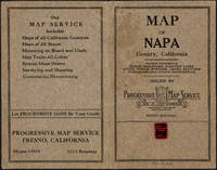
This 1914 map of now popular wine country Napa County, California shows the county in 1914, with early roads, largely undeveloped, vast open land areas, and natural features. The numbered grid system on this map reflects the Public Land Survey System. Large open tracts of land are identified as ranches, such as Rancho Catacoula, or Rancho Las Putas, Rancho LaJota all of which are large swaths of undivided land. Urban grids are shown in the southernmost part of Napa County, and sections of the southernmost sections of Sonoma County and Solano County. The cities of Petaluma, Sonoma, Vallejo and Napa and Benicia show populated urban areas. A corner of Marin County is shown.
C.F. Weber & Co. and the Punnett Brothers published… Read More
Item Price
NZ$1,634.95

More Photos
MEXICO ILLUSTRATED WITH DESCRIPTIVE LETTER-PRESS IN ENGLISH AND SPANISH
by Philips, John
- Used
- near fine
- Hardcover
- Condition
- Used - Near Fine
- Edition
- 1st Facsimile Edition
- Binding
- Hardcover
- Quantity Available
- 1
- Seller
-
Salisbury, Connecticut, United States
- Item Price
-
NZ$1,075.62
Show Details
Description:
Manuel Quesada Brfandi, 1964. 1st Facsimile Edition. Hardcover. Near Fine. Facsimile of 1848 edition, folio, full tan leather gilt-ruled and titles stamped in brown front cover and spine. #306 of 1000 copies. The original edition published in 1848 by E. Atchley, Library of Fine Arts, London. 26 plates each with polished tissue guard, the original lithographs by Messrs Rider and Walker from drawings by John Phillips and printed by Day & Son, lithographer to the Queen. Minor scuffing to corners and spine tips, internals as new. A superior copy.
Item Price
NZ$1,075.62

More Photos
Novissima et Accuratissima Romae Veteris et Novae Tabula Topgraphica Delineatore Ionne Baptista Falda
by Halma and van der Aa
- Used
- Condition
- Used - Good+
- Quantity Available
- 1
- Seller
-
Newcastle, Maine, United States
- Item Price
-
NZ$1,634.95
Show Details
Description:
Halma and van der AaNovissima et Accuratissima Romae Veteris et Novae Tabula Topographica Delineatore Ionne Baptista Falda.After the drawings and map by the architect Giovanni Battista Falda da Valdugga. Originally published in 1667. It contains an amazing amount of detail consisting of: the Coliseum, Pantheon, St. Peter's Basilica, many streets, bridges, various piazzas, and several allegorical scenes including one of St. Peter. The 473 locations are described by the numerical keys on each side of the map. A very good copy, at one time folded over and stubbed into a large folio, and now expertly removed. A scarce map (WorldCat finds only one copy) published [1695] in Leiden.
Item Price
NZ$1,634.95

More Photos
Cosmographie élémentaire : divisée en parties astronomique et géographique
by MENTELLE, Edme
- Used
- near fine
- Hardcover
- Condition
- Used - Near Fine
- Binding
- Hardcover
- Quantity Available
- 1
- Seller
-
COLUMBIA, Missouri, United States
- Item Price
-
NZ$1,290.75
Show Details
Description:
1785 Cosmographia Geography Color MAPS ATLAS Astronomy Physics Asia Africa USAEdme Mentelle was an 18th-century French geographer best-known for his book 'Elementary Cosmographia'. In this book, Mentelle describes the basics of geography and geographic mathematics covering latitude and longitude, world climates, differences in bodies of water, etymology of Asia and Africa, political climate of world nations and powers, with attention given to the Americas, Egypt, France, and many others! Other notable contents include instruction on astrology and astronomy.
Note the inclusion of impressive, folding engraved maps and illustrations throughout!
Item number: #20230
Price: $750
MENTELLE, Edme
Cosmographie élémentaire : divisée en parties astronomique et géographique
A Paris : Chez l'auteur, 1785.
Details:
· Collation: Complete with all pages
o xxxii, 558, [2]
o
13 maps and folding engravings
· Language: French
· Binding: Leather; tight and secure
· Size: ~8in X… Read More
Item Price
NZ$1,290.75

Stock Photo: Cover May Be Different
Tiger Claws : A Novel of India
by Speed, John
- Used
- Condition
- Used - Good
- ISBN 13
- 9780312325510
- ISBN 10
- 0312325517
- Quantity Available
- 1
- Seller
-
Mishawaka, Indiana, United States
- Item Price
-
NZ$9.81
Show Details
Description:
St. Martin's Press. Used - Good. Former library book; may include library markings. Used book that is in clean, average condition without any missing pages.
Item Price
NZ$9.81

Stock Photo: Cover May Be Different
The Temple Dancer : A Novel of India
by Speed, John
- Used
- Condition
- Used - Very Good
- ISBN 13
- 9780312325497
- ISBN 10
- 0312325495
- Quantity Available
- 1
- Seller
-
Mishawaka, Indiana, United States
- Item Price
-
NZ$9.86
Show Details
Description:
St. Martin's Press. Used - Very Good. Used book that is in excellent condition. May show signs of wear or have minor defects.
Item Price
NZ$9.86

Stock Photo: Cover May Be Different
The Temple Dancer : A Novel of India
by Speed, John
- Used
- Condition
- Used - Good
- ISBN 13
- 9780312325480
- ISBN 10
- 0312325487
- Quantity Available
- 1
- Seller
-
Reno, Nevada, United States
- Item Price
-
NZ$10.10
Show Details
Description:
St. Martin's Press. Used - Good. Former library book; may include library markings. Used book that is in clean, average condition without any missing pages.
Item Price
NZ$10.10

The Counties of Britain : A Tudor Atlas
by John Speed
- Used
- Acceptable
- Paperback
- Condition
- Used - Acceptable
- Binding
- Paperback
- ISBN 13
- 9781857936124
- ISBN 10
- 1857936124
- Quantity Available
- 2
- Seller
-
Seattle, Washington, United States
- Item Price
-
NZ$11.38
Show Details
Description:
Pavilion Books, 1995. Paperback. Acceptable. Disclaimer:A readable copy. All pages are intact, and the cover is intact. Pages can include considerable notes-in pen or highlighter-but the notes cannot obscure the text. At ThriftBooks, our motto is: Read More, Spend Less.Dust jacket quality is not guaranteed.
Item Price
NZ$11.38

The Counties of Britain : A Tudor Atlas
by John Speed
- Used
- good
- Paperback
- Condition
- Used - Good
- Binding
- Paperback
- ISBN 13
- 9781857936124
- ISBN 10
- 1857936124
- Quantity Available
- 1
- Seller
-
Seattle, Washington, United States
- Item Price
-
NZ$11.38
Show Details
Description:
Pavilion Books, 1995. Paperback. Good. Disclaimer:A copy that has been read, but remains in clean condition. All pages are intact, and the cover is intact. The spine may show signs of wear. Pages can include limited notes and highlighting, and the copy can include previous owner inscriptions. At ThriftBooks, our motto is: Read More, Spend Less.Dust jacket quality is not guaranteed.
Item Price
NZ$11.38

The Counties of Britain: A Tudor Atlas.
by Speed, John
- Used
- very good
- Hardcover
- Condition
- Used - Very Good
- Binding
- Hardcover
- ISBN 13
- 9781851451319
- ISBN 10
- 1851451315
- Quantity Available
- 2
- Seller
-
Seattle, Washington, United States
- Item Price
-
NZ$11.77
Show Details
Description:
Pavilion Books, 1992. Hardcover. Very Good. May have limited writing in cover pages. Pages are unmarked. ~ ThriftBooks: Read More, Spend Less.Dust jacket quality is not guaranteed.
Item Price
NZ$11.77

The Temple Dancer : A Novel of India
by John Speed
- Used
- Acceptable
- Paperback
- Condition
- Used - Acceptable
- Binding
- Paperback
- ISBN 13
- 9780312325497
- ISBN 10
- 0312325495
- Quantity Available
- 1
- Seller
-
Seattle, Washington, United States
- Item Price
-
NZ$11.81
Show Details
Description:
St. Martin's Press, 2007. Mass Market Paperback. Acceptable. Readable copy. Pages may have considerable notes/highlighting. ~ ThriftBooks: Read More, Spend Less.Dust jacket quality is not guaranteed.
Item Price
NZ$11.81
Stock Photo: Cover May Be Different
Tiger Claws : A Novel of India
by Speed, John
- Used
- Condition
- Used - Like New
- ISBN 13
- 9780312325510
- ISBN 10
- 0312325517
- Quantity Available
- 1
- Seller
-
Reno, Nevada, United States
- Item Price
-
NZ$12.15
Show Details
Description:
St. Martin's Press. Used - Like New. Used book that is in almost brand-new condition.
Item Price
NZ$12.15
Stock Photo: Cover May Be Different
The Temple Dancer : A Novel of India
by Speed, John
- Used
- Condition
- Used - Good
- ISBN 13
- 9780312325497
- ISBN 10
- 0312325495
- Quantity Available
- 1
- Seller
-
Mishawaka, Indiana, United States
- Item Price
-
NZ$12.20
Show Details
Description:
St. Martin's Press. Used - Good. Used book that is in clean, average condition without any missing pages.
Item Price
NZ$12.20

Tiger Claws : A Novel of India
by John Speed
- Used
- good
- Paperback
- Condition
- Used - Good
- Binding
- Paperback
- ISBN 13
- 9780312384593
- ISBN 10
- 0312384599
- Quantity Available
- 1
- Seller
-
Seattle, Washington, United States
- Item Price
-
NZ$13.18
Show Details
Description:
St. Martin's Press, 2008. Paperback. Good. Pages can have notes/highlighting. Spine may show signs of wear. ~ ThriftBooks: Read More, Spend Less.Dust jacket quality is not guaranteed.
Item Price
NZ$13.18

More Photos
The Sky and the Forest
by Forester, C.S
- Used
- very good
- Hardcover
- first
- Condition
- Used - Very Good
- Jacket Condition
- Very Good
- Edition
- First Edition
- Binding
- Hardcover
- Quantity Available
- 1
- Seller
-
Salem, Oregon, United States
- Item Price
-
NZ$60.05NZ$36.02Save NZ$13.96!
Show Details
Description:
C.S. Forester: The Sky and the Forest. Little, Brown and Company, Boston. Stated First Edition First Printing Thus August, 1948. Cover price $2.75. Used. VG BOOK/VG UNCLIPPED DUST JACKET. A story of a central Africa. By C.S. Forester, author of the Admiral Hornblower series.
Item Price
NZ$60.05NZ$36.02
Save NZ$13.96
!
![Alaska and Klondike Region; [With inset of Klondike Region on the Upper Yukon detail] [From an...](https://d3525k1ryd2155.cloudfront.net/h/062/537/1339537062.0.m.jpg)
Alaska and Klondike Region; [With inset of Klondike Region on the Upper Yukon detail] [From an atlas, "Gazetteer of Alaska and Yukon Region " pp. 105 and 106]
by Miller, J. Martin
- Used
- very good
- Condition
- Used - Very Good
- Edition
- Unknown
- Quantity Available
- 1
- Seller
-
Sebastopol, California, United States
- Item Price
-
NZ$67.12
Show Details
Description:
Chicago: J. Martin Miller, 1899. Unknown. Map. Very Good. [Map copyright 1899, printing date of Atlas later] [19.875x15.125in]; Colored map of Alaska with steamer routes from Portland and Seattle, insets of the Klondike Region on the Upper Yukon and Western portion of Aleutian Islands; On verso index of places and names with two large black and white images; Age toning to all edges, water stain marks on bottom, slight printing offset of colors, small chips and closed tears to lower edge;.
Item Price
NZ$67.12

Zemepis Sveta - Monsunova Asie
by De La Blache, P. Vidal; Gallois, L
- Used
- Hardcover
- Condition
- Used - Very Good Condition
- Jacket Condition
- No Dust Jacket
- Binding
- Hardcover
- Quantity Available
- 1
- Seller
-
Oak Point, Texas, United States
- Item Price
-
NZ$103.26
Show Details
Description:
Aventinum, Prague, Czechoslovakia, 1931. Hardcover. Very Good Condition/No Dust Jacket. Text entirely in Czech. Geography book on Asia with numerous photographs and maps. 1930 edition also available. Size: 4mo - over 9 3/4" - 12" tall. 400 pp. Pages are yellowed, but are tight and clean. Moderate shelfwear along the spine. Corners are lightly bumped. Quantity Available: 1. Shipped Weight: 3-5 pounds. Category: Travel & Places; Non-English Language::Czech; Pictures of this item not already displayed here available upon request. Inventory No: 001228. . Additional shipping charges may apply.
Item Price
NZ$103.26

Zemepis Sveta - Monsunova Asie
by De La Blache, P. Vidal; Gallois, L
- Used
- Hardcover
- Condition
- Used - Very Good Condition
- Jacket Condition
- No Dust Jacket
- Binding
- Hardcover
- Quantity Available
- 1
- Seller
-
Oak Point, Texas, United States
- Item Price
-
NZ$103.26
Show Details
Description:
Aventinum, Prague, Czechoslovakia, 1930. Hardcover. Very Good Condition/No Dust Jacket. Text entirely in Czech. Geography book on Asia with numerous photographs and maps. 1931 edition also available. Size: 4mo - over 9 3/4" - 12" tall. 400 pp. Pages are yellowed, but are tight and clean. Moderate shelfwear along the spine. Corners are lightly bumped. Quantity Available: 1. Shipped Weight: 3-5 pounds. Category: Travel & Places; Non-English Language::Czech; Pictures of this item not already displayed here available upon request. Inventory No: 001227. . Additional shipping charges may apply.
Item Price
NZ$103.26

North America from the Best Authorities, Russell, ca.1800
by Russell
- Used
- Condition
- Used
- Quantity Available
- 1
- Seller
-
Plymouth, Devon, United Kingdom
- Item Price
-
NZ$42.83
Show Details
Description:
Russell, J. : A General Map of North America from the Best Authorities. Nd but ca.1800. From "A New Geographical, Historical and Commercial Grammar and Present State of Several Kingdoms of the World." Copper engraving. Size approx 200 x 230mm. Two neat folds. Some age colouring to edges, otherwise very clean and bright.
Item Price
NZ$42.83

Asia from the Best Authorities, Russell, ca.1800
by Russell
- Used
- Condition
- Used
- Quantity Available
- 1
- Seller
-
Plymouth, Devon, United Kingdom
- Item Price
-
NZ$42.83
Show Details
Description:
Russell, J. : Asia from the Best Authorities. Nd but ca.1800. From "A New Geographical, Historical and Commercial Grammar and Present State of Several Kingdoms of the World". Copper engraving. Size approx 200 x 230mm. Two neat folds. Some age colouring to edges, otherwise clean and bright. Includes Arabia, India, Borneo, Japan, China and eastern Russia.
Item Price
NZ$42.83
![MAP OF UTAH [Territory]](https://d3525k1ryd2155.cloudfront.net/h/836/461/1485461836.0.m.jpg)
More Photos
MAP OF UTAH [Territory]
- Used
- Condition
- Used - Very Good-
- Edition
- Original
- Quantity Available
- 1
- Seller
-
Williamsburg, Virginia, United States
- Item Price
-
NZ$111.87
Show Details
Description:
New York, Richmond, Chicago, & Toledo: H. H. Hardesty, 1885. Original color lithographed map printed by Rand, McNally & Company, Engravers and published in HARDESTY'S HISTORICAL AND GEOGRAPHICAL ENCYCLOPEDIA: SPECIAL VIRGINIA EDITION. 19 3/8 inches by 13 1/4 inches on a 21" X 14 1/2" sheet. The map depicts the Territory of Utah in its final form--large areas had been removed and ceded to Nevada, Colorado, Wyoming, and Nebraska since Utah became a U. S. Territory in 1850. The issue of polygamy prevented statehood until it was finally granted in 1896. This map features railroads and topography and uses color to set off counties from each other. Unlike most atlas maps of the period, this map identifies most small towns. The map is guaranteed to be moe than 135 years old. The map is in about very good condition: generally clean and bright, with slight toning of paper and one faint water stain near the center-left edge of the map.. Original. Single Sheet. Very Good-. Elephant…
Read More Item Price
NZ$111.87

Last Tales
by Dinesen, Isak
- Used
- very good
- Hardcover
- first
- Condition
- Used - Very Good
- Jacket Condition
- Good+
- Edition
- First Edition
- Binding
- Hardcover
- Quantity Available
- 1
- Seller
-
Salem, Oregon, United States
- Item Price
-
NZ$206.52NZ$123.91Save NZ$48.00!
Show Details
Description:
Dinesen, Isak: Last Tales, A Collection of Twelve New Tales of Compelling Beauty 1957, Random House. First Edition. Stated First Printing Thus. Used. Very Good/Good+ original red dust jacket, price-clipped. Jacket states 11/57 on front flap. 5 3/4 X
Item Price
NZ$206.52NZ$123.91
Save NZ$48.00
!

Philips Special Map of the Nile, The Advance on Khartum and the Environs of Omdurman. Cc1900
by George Philips and Son,
- Used
- Condition
- Used
- Quantity Available
- 1
- Seller
-
Plymouth, Devon, United Kingdom
- Item Price
-
NZ$55.67
Show Details
Description:
Philips Special map of the Nile illustrating the Advance on Khartum [Khartoum] with an enlargement of the environs of Omdurman [Omdur]. George Philips and Son, London and Liverpool Ca 1900. 580mm x 900mm folded map. Front title wrapper has come loose, not affecting map area. Three maps are displayed within the sheet. Map1. Map of the Nile Valley 520mm x 300mm showing the approaches of Khartum. Scale 1inch to 100 Geographical miles. Coloured indicating Possessions and Protectorates of European Powers. Map 2. Special map of the Nile from Dongola to Khartum. Scale 16 miles to the inch. Coloured. In set in this map is Map3. Environs of Omdurman, Scale 5 statute miles to the inch. Some small breaks at some folds, not affecting imagery or use of map. Title label is damaged, the map is clean and bright, probably unused. A very interesting record.
Item Price
NZ$55.67

The Adventure of Wrangel Island
by Vilhjalmur Stefansson
- Used
- good
- Hardcover
- first
- Condition
- Used - Good
- Jacket Condition
- No DJ Included
- Edition
- First Edition
- Binding
- Hardcover
- Quantity Available
- 1
- Seller
-
Salem, Oregon, United States
- Item Price
-
NZ$214.94NZ$128.95Save NZ$49.96!
Show Details
Description:
The Adventure of Wrangel Island, Alaska (1925 Macmillan 1st Edition) HISTORY OF ALASKA. EXLIB. Good Condition/ No DJ included. Fold-out map affixed to binding at the back of the book has never been opened. The story of the (unsuccessful) attempted colonization of Wrangel Island Alaska. 413 pages plus appendix, Index. Titling is still bright. A clean, solid copy. Scarce.
Item Price
NZ$214.94NZ$128.95
Save NZ$49.96
!
