Description:
Boston: Lee And Shepard. Spine ends incomplete, corners worn, lacking the map else about good plus.. 1887. Hardcover. 12mo 7" - 7½" tall; Publisher's pictorial tan cloth with large illustratio n printed in black on front board, 341p., illustrated, ads. **Bruns F-13. .
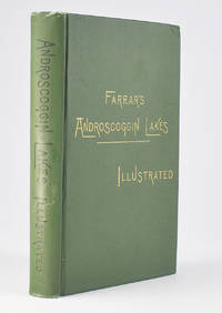
Farrar's Illustrated Guide Book to Androscoggin Lakes by Farrar, Capt. Charles A.J
by Farrar, Capt. Charles A.J
Similar copies are shown below.
Similar copies are shown to the right.
Farrar's Illustrated Guide Book to Androscoggin Lakes
by Farrar, Capt. Charles A.J
- Used
Boston: Lee and Shepard, 1888. 12mo (7.5" x 5.5"), green cloth, gilt-title at front cover, black title at spine. 344 pp. 24 pp. of ads. Folding map, 22" x 25.5", plus margins. As described on the verso of the title page, illustrations for this book "were drawn expressively for it by Nat. Brown, C.W. Reed, M.M. Tidd, F. Myrik, E.H. Garrett, F.C. Hassam and others from Photographs and Sketches made at the places represented, under the supervision of Capt. Farrar, and were engraved by Nat. Brown, Geo. E. Johnson, W.H. Bricher, and other first-class artists."
A lovely copy of the sixth edition of this title (by Williamson's reckoning), which first appeared in 1883, being a delightful guide to the Androscoggin Lakes region, with detailed descriptions and fine illustrations. Included here are chapters on routes from Boston to the region, the "Upper Dam and Richardson Ponds," "The lower Magalloway and Diamond Rivers," "Catches of Trout and Landlocked Salmon," "Rates of Fare and Round Trip Excursion Tickets," etc. The large folding map at the front is entitled Farrar's New Map of the Rangeley Lakes Region and the Headwaters of the Connecticut, Magalloway, Androscoggin, Sandy and Dead Rivers. Showing all Railroad, Stage and Steamboat Routes , County and Wood Roads, Hotels, Camps and Post Offices. Drawn Expressly for Farrar's Androscoggin lakes. Illustrated by Capt. Chas. A. J. Farrar. Revised 1888. Farrar's preface is entitled "Preface to the Eleventh Edition," but as Thompson points out he seems to be including all of his guide books in this count regardless of title, beginning with his 1876 guide to Rangeley.
The most prolific 19th century writer on the Maine woods, Capt. Farrar began writing his guides as a promotion for his Richardson Lake properties and commercial transportation company in 1876. In addition to his Androscoggin Lakes, Rangeley, and Moosehead Lake guide-books, he also wrote a series of camping narratives, including Camp Life in the Wilderness, From Lake to Lake, and Through the Wilds, as well as four north woods adventure stories: Eastward Ho!, Wild Woods Life, Down the West Branch, and Up the North Branch.
REFERENCES: Williamson, A Bibliography of the State of Maine, #3272; Thompson, Edward V. Important Maine Maps, Books, Prints and Ephemera. Orono, 2003, pp. 410-411.
CONDITION: Good+, bright with minimal wear, upper fore-corners bumped, contents bright and clean; map with some tears, breaks, and separation at folds, but not especially fragile and basically sound.
-
Bookseller
James Arsenault & Company
 (US)
(US)
- Book Condition Used
- Quantity Available 1
- Publisher Boston: Lee and Shepard, 1888
We have 3 copies available starting at NZ$215.12.

Farrar's Illustrated Guide Book to the Androscoggin Lakes, At the Head-Waters Of the Connecticut, Magalloway, and Androscoggin Rivers, Dixville Notch, Grafton Notch, and Andover, Maine, and Vicinity...
by Farrar, Charles A. J. , Capt
- Used
- Hardcover
- Condition
- Used - Spine ends incomplete, corners worn, lacking the map else about good plus.
- Binding
- Hardcover
- Quantity Available
- 1
- Seller
-
Westmoreland, New Hampshire, United States
- Item Price
-
NZ$215.12
Show Details
Item Price
NZ$215.12

Farrar's Illustrated Guide Book to the Androscoggin Lakes, and the Head-Waters of the Connecticut, Magalloway, and Androscoggin Rivers, Dixville Notch, Grafton Notch, and Andover, Maine, and Vicinity
by Farrar, Capt. Charles A. J
- Used
- Hardcover
- first
- Condition
- Used - VG+
- Jacket Condition
- Not Issued
- Edition
- First Thus
- Binding
- Hardcover
- Quantity Available
- 1
- Seller
-
Kutztown, Pennsylvania, United States
- Item Price
-
NZ$335.60
Show Details
Description:
Boston, MA: Lee and Shepard, 1884. Book. VG+. Decorative Cloth. First Thus. 12mo - over 6¾" - 7¾" tall. Light brown cloth, front cover illus./title in black. Modest shelf wear, lightly rubbed at corners and spine extremities, cloth slightly puckered at two points on front cover. Text block edges a bit toned by age. Firm binding, clean interior. 9th ed. (according to pp. 9-10 preface). 356,[4] pp., illus., unfortunately lacking the map, which has been torn from its binding mount following a front blank, opposite an ad for Conroy's Celebrated Hexagonal Split Bamboo Rod. Mounted on front and rear pastedowns are, respectively, color advertisements for Boston & Maine Railroad's excursions to Old Orchard, Portland, Lake Winnepesaukee, Mount Desert and the White Mountains and for B&M RR's Summer Excursions, both of which we assume to be original to issue/distribution..
Item Price
NZ$335.60

More Photos
Farrar's Illustrated Guide Book to the Androscoggin Lakes, and the Head-Waters of the Connecticut, Magalloway, and Androscoggin Rivers, Dixville Notch, Grafton Notch, and Andover, Maine, and Vicinity...
by Farrar, Captain Charles A.J
- Used
- Hardcover
- Condition
- Used - Very Good Minus
- Edition
- 12th Edition
- Binding
- Hardcover
- Quantity Available
- 1
- Seller
-
Newburyport, Massachusetts, United States
- Item Price
-
NZ$370.02
Show Details
Description:
Boston/New York: Lee and Shephard/ Charles T. Dillingham, 1890 Reprint of the 1887 edition (12th edition). Hard cover 12 mo in green publisher's cloth with title blocked in gold to front board and in black to spine, with tan floral end papers, 73 engraved illustrations by various artists, including Nat. Brown, C.W. Reed, M.M. Tidd, F. Myrick, E.H. Garrett, F.C. Hassam, and W.H. Bricher. CONDITION: Lacking foldout Map, otherwise Very Good Minus. Light soiling and rubbing and to boards. Text block edges a bit dusty. A few pages within are soiled, (showing use as a guidebook would.)** Full of vintage advertising, as well as numerous engraved prints, many illustrating the author's methods of transport available for the early tourist. Articles recommend travel routes from Boston, some of the perils of camping, favorable fishing spots and the like.**Captain Charles Alden John Farrar (1842-1893), publisher of this guide, trained as a printer in Boston as a teen, later becoming a newspaper editor. His…
Read More Item Price
NZ$370.02