Click for full-size.

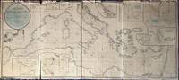
A New Chart of the Mediterranean Sea, Comprehending the Coasts from Cape St. Mary, (in Portugal) to Constantinople, and from Rabat, in Africa, to Alexandretto, or Iskenderoon, in Asia &c. Reduced from the new Spanish and French Charts made by Order of the respective Governments, From Several Documents of Lord Viscount Nelson, and other recent Authorities, By Joseph Dessiou, Master, &c.
by Dessiou (Joseph)
- Used
- Condition
- See description
- Seller
-
Sidney, British Columbia, Canada
Payment Methods Accepted
About This Item
London: Laurie, 2nd August, 1819. . A large copper engraved "blueback" map on paper, backed with the usual blue manila paper. Large coloured circular-bordered title in upper left, lettered in script. Entire map with contemporary colouring in outline. Thirteen small inset maps. Imprint at bottom: Published 2nd August, 1819, by Richard Holmes Laurie, Chart Seller to the Admiralty, &c.&c. No. 53, Fleet Street, London. Image size is 173cm x 76cm, on a sheet measuring 175cm x 78cm. The map is in five sections, four the same size and one smaller. Some splitting at folds, fraying to upper edge but very little loss, very good condition generally. Beneath the title is a note on the map: "Accompanied with an enlarged Book of Sailing Directions". WorldCat lists an edition of Laurie's book of directions [not present here]: "Laurie and Whittle's New Sailing Directions for the Mediterranean Sea ... Written to accompany the New Chart of the Mediterranean Sea, and compiled from the best Authorities, aided by several original and valuable Manuscripts of the late Horatio, Lord Viscount Nelson ... of Capt. G.F. Ryves, of the Royal Navy ; and of Joseph Dessiou, author of the Chart. The Second Edition, greatly enlarged and improved. [With a note on the pirated issue of the First Edition, published by Robert Blachford, of the Minories, London]. London : Robert Laurie and James Whittle, 1811. 112 pages. The only copy of this book cited is in the British Library, whose entry says: "Missing the chart". This 1819 edition of the chart is not cited by Hughes & Wall in their comprehensive work on Joseph Dessiou's publications, but they do cite an 1811 edition held by McMaster University, upon which it is based: [Dessioul4, McM: Laurie and Whittle's New Chart of the Mediterranean Sea Comprehending the Coast from Cape St. Mary, (in Portugal) to Constantinople, and from Rabat, in Africa, to Alexandretto, or Scanderoon in Asia. Joseph Dessiou, Master Mariner, Laurie and Whittle, 1811]. This 1811 edition has some variations from the 1819 edition in the title (Nelson is mentioned in both, but named differently), only ten inset maps (this 1819 edition has 13 insets), some different names (Skanderoon; this 1819 edition says Iskenderoon), and refers to itself beneath the title as "An Improved Edition, With Additions, 1811". This same chart is the basis of the [c.1826] edition which added information from the surveys of William Henry Smyth. The 1826 edition is the same size, contains more details and inset maps (19 insets), and some corrections ('Maddalena Islands' instead of 'Magdalena Islands'). All editions are very rare; the 1811 edition is known to us in two copies (McMaster University and University of Amsterdam); this copy of the 1819 edition is the only one we are able to locate; the 1826 edition is known in only one copy (Ruderman/Boston Rare Maps).
Reviews
(Log in or Create an Account first!)
Details
- Bookseller
- William Matthews, Bookseller / The Haunted Bookshop
 (CA)
(CA)
- Bookseller's Inventory #
- 55999
- Title
- A New Chart of the Mediterranean Sea, Comprehending the Coasts from Cape St. Mary, (in Portugal) to Constantinople, and from Rabat, in Africa, to Alexandretto, or Iskenderoon, in Asia &c. Reduced from the new Spanish and French Charts made by Order of the respective Governments, From Several Documents of Lord Viscount Nelson, and other recent Authorities, By Joseph Dessiou, Master, &c.
- Author
- Dessiou (Joseph)
- Book Condition
- Used
- Quantity Available
- 1
- Publisher
- London: Laurie, 2nd August, 1819.
- Weight
- 0.00 lbs
- Bookseller catalogs
- Maps;
Terms of Sale
William Matthews, Bookseller / The Haunted Bookshop
Prices are in US Dollars. Books are guaranteed to be as described. Books may be returned within a reasonable length of time. Paypal Payments are made to: bill@rainbownorth.com
About the Seller
William Matthews, Bookseller / The Haunted Bookshop
Biblio member since 2004
Sidney, British Columbia
About William Matthews, Bookseller / The Haunted Bookshop
Established 1976. Open shop in Victoria BC, Open Wed-Sun 11-5. Specialists in weird, fantastic, supernatural,utopian, interplanetary, science fiction and lost race fiction; also rare books, literary first editions, poetry broadsides. Antiquarian maps, charts, views, prints, engravings.
Glossary
Some terminology that may be used in this description includes:
- Worldcat
- Worldcat is a collaborative effort produced by OCLC (Online Computer Library Center) and supported and used by 72,000 libraries...
- New
- A new book is a book previously not circulated to a buyer. Although a new book is typically free of any faults or defects, "new"...
- G
- Good describes the average used and worn book that has all pages or leaves present. Any defects must be noted. (as defined by AB...
- First Edition
- In book collecting, the first edition is the earliest published form of a book. A book may have more than one first edition in...
This Book’s Categories

Collecting the 1939 New York World’s Fair
Born in the midst of the Great Depression, the theme of the 1939 World’s Fair was “The World of Tomorrow” - a theme that captured the hearts of a generation. Check out the maps, souvenirs, and other ephemera on Biblio!

Cleaning and repairing leather books
Wondering how to take care of the leather books in your collection? Renowned book care expert Bern Marcowitz explains how and when to clean and repair leather books.
Also Recommended
-

-
-

-
-

Save 10% on every purchase!
Join the Bibliophiles’ Club and start saving 10% on every book.
$29.95 / Year
