
Click for full-size.
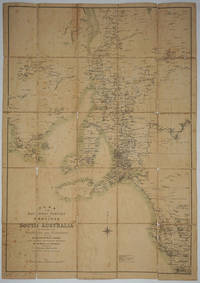
Plan of the Southern Portion of the Province of South Australia as Divided into Counties and Hundreds Showing Agricultural Areas, Post Towns, Telegraph Stations, Main Roads and Railways; Compiled from Official Documents
by Weller, Edward
- Used
- Condition
- Good condition
- Seller
-
Garrison, New York, United States
Payment Methods Accepted
About This Item
London: Sampson Low & Co, 1887. Good condition. Dissected map on canvas of South Australia. The right hand set of panels are detached; the map with scattered fox spotting, somewhat dusty, obviously well used, nevertheless presentable.
Trove 7146934 locates a copy at the National Library of Australia in their Ferguson Collection, Map 292. The only Weller map of South Australia we have located in Tooley is 1554, titled South Australia, published by Sampson, Low in London; but there is no expansion of the entry. 23x33"
Trove 7146934 locates a copy at the National Library of Australia in their Ferguson Collection, Map 292. The only Weller map of South Australia we have located in Tooley is 1554, titled South Australia, published by Sampson, Low in London; but there is no expansion of the entry. 23x33"
Reviews
(Log in or Create an Account first!)
Details
- Bookseller
- Antipodean Books, Maps & Prints
 (US)
(US)
- Bookseller's Inventory #
- 25017
- Title
- Plan of the Southern Portion of the Province of South Australia as Divided into Counties and Hundreds Showing Agricultural Areas, Post Towns, Telegraph Stations, Main Roads and Railways; Compiled from Official Documents
- Author
- Weller, Edward
- Book Condition
- Used - Good condition
- Quantity Available
- 1
- Publisher
- Sampson Low & Co
- Place of Publication
- London
- Date Published
- 1887
- Bookseller catalogs
- MAPS; AUSTRALIA; SOUTH AUSTRALIA;
Terms of Sale
Antipodean Books, Maps & Prints
30 day return guarantee, with full refund including shipping costs for up to 10 days after delivery if an item arrives mis-described or damaged.
About the Seller
Antipodean Books, Maps & Prints
Biblio member since 2009
Garrison, New York
About Antipodean Books, Maps & Prints
Booksellers for over 40 years, members of prominent trade associations (ABAA, ILAB, ANZAAB, IMCOS, ANZMS, PBFA). We are located at Garrison NY, a stone's throw from the Metro North Hudson line train, just over 1 hr. from NYC on the banks of the Hudson River. Books, maps, prints & ephemera bought & sold.
This Book’s Categories

Cleaning and repairing leather books
Wondering how to take care of the leather books in your collection? Renowned book care expert Bern Marcowitz explains how and when to clean and repair leather books.

Beat Poet Michael McClure
From the fateful reading at Six-Gallery in 1955 to his novels, poetry, and stage productions, Michael McClure was right in the thick of the Beat Generation as it was born. See his books and art and learn more about the works of Michael McClure.