Description:
J. H. Colton & Co.. Fine. 1855. Map. Fine 1855 Colton map of New Jersey. Hand colored. ; 18" x 15 1/2" inches; 1 pages .
Search Results: Maps from Elders Bookstore
You searched for:
- Subject: Maps from Elders Bookstore
Results 1 - 20 of 34

1855 Colton Map of the State of New Jersey
by Colton, J. H.
- Used
- Fine
- Condition
- Used - Fine
- Quantity Available
- 1
- Seller
-
Nashville, Tennessee, United States
- Item Price
-
NZ$299.60NZ$17.98 shipping to USA
Show Details
Item Price
NZ$299.60
NZ$17.98
shipping to USA
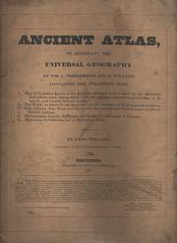
Ancient Atlas to Accompany the Universal Geography
by Woodbridge, William and Willard, Emma
- Used
- Paperback
- Condition
- Used - Good+
- Binding
- Paperback
- Quantity Available
- 1
- Seller
-
Nashville, Tennessee, United States
- Item Price
-
NZ$428.00NZ$17.98 shipping to USA
Show Details
Description:
Hartford, Conn.: Oliver D. Cooke & Co.. Good+. 1827. Softcover. Good+ softcover edition, no names or marks. Cover is worn and spotted. Maps are bright, but have some minor soiling or foxing along the edges. There is an extra page with two maps of Canaan from the same time period that have been laid in at the front. ; 4to 11" - 13" tall .
Item Price
NZ$428.00
NZ$17.98
shipping to USA
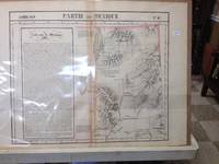
Atlas Universel De Geographie, Physique, Politique Et Mineralogique North America - Map of Present Day New Mexico (Partie Du Mexique)
by Vandermaelen, Philippe
- Used
- very good
- Condition
- Used - Very Good
- Quantity Available
- 1
- Seller
-
Nashville, Tennessee, United States
- Item Price
-
NZ$847.44NZ$17.98 shipping to USA
Show Details
Description:
Brussels, Belgium: Lithographed By H. Ode. Very Good. 1827. Map. Map #54 Very Good The map includes present day New Mexico, a small part of Northern Mexico and some of very northwestern Texas. It is double page, 3 color and black and white, topographical features are accentuated. A fifteen line description in French is super imposed on the left side of the map - covers about 6" x 1 3/4". The condition is very good. Darkening appears along the centerfold where map was attached by a tab to the atlas. Scale of the map is 26 miles per one inch. Lithograpy was done by Henri Ode. In conjunction with cartographer Philippe Vandermaelen, they produced the first lithographed atlas ever done. It provides on a large scale a picture of many newly explored areas, as in this case, the Western United States. Photo available upon request. ; 21" x 26 1/2"; 1 pages .
Item Price
NZ$847.44
NZ$17.98
shipping to USA
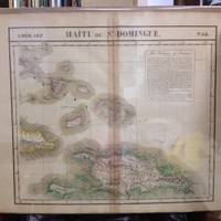
Atlas Universel De Geographie, Physique, Politique Et Mineralogique North America - Map of the Bahama Islands and Haiti (Haiti Ou St. Dominque)
by Vandermaelen, Philippe
- Used
- very good
- Condition
- Used - Very Good
- Quantity Available
- 1
- Seller
-
Nashville, Tennessee, United States
- Item Price
-
NZ$407.46NZ$17.98 shipping to USA
Show Details
Description:
Brussels, Belgium: Lithographed By H. Ode. Very Good. 1827. Map. Map # 68, A Very Good primitive and early map of the Bahama Islands and the Island of Haiti or Santo Domingo, also shows the eastern tip of Cuba. Latitude of the map is 18 degrees to 24 degrees and longitude is 70 degrees to 78 degrees. Of course, almost all localities shown are French or Indian names. The atlas from which this is extracted is extremely rare and originally composed 6 volumes, this map being from the North America volume. Lithographer Ode and Cartographer Vandermaelen produced the first lithographed atlas ever done. Condition is overall Very Good. Browning to the centerfold crease caused by glue used in attaching the tab to the original volume, the two page spread measures 21" x 26 1/2" when opened out. Topigraphical features are accentuated, see image. Shipping will require extra care and cost due to insurance. Photo available upon request. ; 21" x 26 1/2"; 1 pages .
Item Price
NZ$407.46
NZ$17.98
shipping to USA

Atlas Universel De Geographie, Physique, Politique Et Mineralogique North America - Map of Vancouver British Columbia and Vancouver Island (Partie De La Nouvelle Hanovre)
by Vandermaelen, Philippe
- Used
- very good
- Condition
- Used - Very Good
- Quantity Available
- 1
- Seller
-
Nashville, Tennessee, United States
- Item Price
-
NZ$770.40NZ$17.98 shipping to USA
Show Details
Description:
Brussels, Belgium: Lithographed By H. Ode. Very Good. 1827. Map. Map # 51, A Very Good primitive and early map showing Vancouver, British Columbia and Vancouver Island in Canada. Includes some of extreme NW Washington state adjacent to, but not including Seattle, also includes the city of Victoria. Very nice multi-color depiction of the larger British Columbia coastline. Latitude of the map is 48 degrees to 54 degrees and longitude is 119 degrees to 131 degrees. Of course, almost all localities shown are French or Indian names. The atlas from which this is extracted is extremely rare and originally composed 6 volumes, this map being from the North America volume. Lithographer Ode and Cartographer Vandermaelen produced the first lithographed atlas ever done. Condition is overall Very Good. Browning to the centerfold crease caused by glue used in attaching the tab to the original volume, the two page spread measures 21" x 26 1/2" when opened out. Topigraphical features are…
Read More Item Price
NZ$770.40
NZ$17.98
shipping to USA
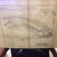
Atlas Universel De Geographie, Physique, Politique Et Mineralogique North America - Map of Newfoundland (Partie De L'Ile De Terre Neuve)
by Vandermaelen, Philippe
- Used
- very good
- Condition
- Used - Very Good
- Quantity Available
- 1
- Seller
-
Nashville, Tennessee, United States
- Item Price
-
NZ$513.60NZ$17.98 shipping to USA
Show Details
Description:
Brussels, Belgium: Lithographed By H. Ode. Very Good. 1827. Map. Map # 37, A Very Good primitive and early map showing Newfoundland, present day and eastern part, includes the city of Bonavista. Nice color depiction of the coastline. Latitude of the map is 48 degrees to 54 degrees and longitude is 47 degrees to 59 degrees. Of course, almost all localities shown are French or Indian names. The atlas from which this is extracted is extremely rare and originally composed 6 volumes, this map being from the North America volume. Lithographer Ode and Cartographer Vandermaelen produced the first lithographed atlas ever done. Condition is overall Very Good. Browning to the centerfold crease caused by glue used in attaching the tab to the original volume, the two page spread measures 21" x 26 1/2" when opened out. Topigraphical features are accentuated, see image. Shipping will require extra care and cost due to insurance. Photo available upon request. ; 21" x 26 1/2"; 1 pages .
Item Price
NZ$513.60
NZ$17.98
shipping to USA
Atlas Universel De Geographie, Physique, Politique Et Mineralogique North America - Map of Southern Yukon Territory (Grand Lac De L'Esclave)
by Vandermaelen, Philippe
- Used
- very good
- Condition
- Used - Very Good
- Quantity Available
- 1
- Seller
-
Nashville, Tennessee, United States
- Item Price
-
NZ$428.00NZ$17.98 shipping to USA
Show Details
Description:
Brussels, Belgium: Lithographed By H. Ode. Very Good. 1827. Map. Map # 15, A Very Good primitive and early map showing the southern Yukon Territory and the southwestern part of the Northwest Territory. Includes the Great Slave lake, depicted in black, white and gray shades. Latitude of the map is 60 degrees to 65 degrees and longitude is 114 degrees to 130 degrees. Of course, almost all localities shown are French or Indian names. The atlas from which this is extracted is extremely rare and originally composed 6 volumes, this map being from the North America volume. Lithographer Ode and Cartographer Vandermaelen produced the first lithographed atlas ever done. Condition is overall Very Good. Browning to the centerfold crease caused by glue used in attaching the tab to the original volume, the two page spread measures 21" x 26 1/2" when opened out. Topigraphical features are accentuated, see image. Shipping will require extra care and cost due to insurance. Photo available upon…
Read More Item Price
NZ$428.00
NZ$17.98
shipping to USA
Atlas Universel De Geographie, Physique, Politique Et Mineralogique North America - Map of the Yucatan Penninsula (Merida)
by Vandermaelen, Philippe
- Used
- very good
- Condition
- Used - Very Good
- Quantity Available
- 1
- Seller
-
Nashville, Tennessee, United States
- Item Price
-
NZ$684.80NZ$17.98 shipping to USA
Show Details
Description:
Brussels, Belgium: Lithographed By H. Ode. Very Good. 1827. Map. Map # 66, A Very Good primitive and early map showing the Yucatan Penninsula coastline. Includes present day provinces of Yucatan, Ouintara Roo, Compecha and Tobasco. Also includes a small portion of Northern Belize. Cities include Merida, Compeche Chetumal and Cuido del Carmen, eastern tip of Cuba is shown. Latitude of the map is 18 degrees to 24 degrees and longitude is 86 degrees to 94 degrees. Of course, almost all localities shown are French or Indian names. The atlas from which this is extracted is extremely rare and originally composed 6 volumes, this map being from the North America volume. Lithographer Ode and Cartographer Vandermaelen produced the first lithographed atlas ever done. Condition is overall Very Good. Browning to the centerfold crease caused by glue used in attaching the tab to the original volume, the two page spread measures 21" x 26 1/2" when opened out. Topigraphical features are…
Read More Item Price
NZ$684.80
NZ$17.98
shipping to USA
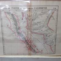
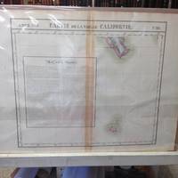
Atlas Universel De Geographie, Physique, Politique Et Mineralogique North America - Map of Northern California Coast
by Vandermaelen, Philippe
- Used
- very good
- Condition
- Used - Very Good
- Quantity Available
- 1
- Seller
-
Nashville, Tennessee, United States
- Item Price
-
NZ$1,498.00NZ$17.98 shipping to USA
Show Details
Description:
Brussels, Belgium: Lithographed By H. Ode. Very Good. 1827. Map. Map # 46, A Very Good primitive and early map showing the northern California coast with San Francisco and Monterey. Map has wonderful color and many small text descriptions of the coast lines. Latitude of the map is 36 degrees to 42 degrees and longitude is 120 degrees to 150 degrees. Of course, almost all localities shown are French or Indian names. The atlas from which this is extracted is extremely rare and originally composed 6 volumes, this map being from the North America volume. Lithographer Ode and Cartographer Vandermaelen produced the first lithographed atlas ever done. Condition is overall Very Good. Browning to the centerfold crease caused by glue used in attaching the tab to the original volume, the two page spread measures 21" x 26 1/2" when opened out. Topigraphical features are accentuated, see image. Shipping will require extra care and cost due to insurance. Photo available upon request. ;…
Read More Item Price
NZ$1,498.00
NZ$17.98
shipping to USA
Atlas Universel De Geographie, Physique, Politique Et Mineralogique North America - Map of Central California Coast
by Vandermaelen, Philippe
- Used
- very good
- Condition
- Used - Very Good
- Quantity Available
- 1
- Seller
-
Nashville, Tennessee, United States
- Item Price
-
NZ$1,198.40NZ$17.98 shipping to USA
Show Details
Description:
Brussels, Belgium: Lithographed By H. Ode. Very Good. 1827. Map. Map # 52, A Very Good primitive and early map showing the central California coast with Santa Barbara and others. Map has wonderful color and many small text descriptions of the coast lines. Latitude of the map is 30 degrees to 36 degrees and longitude is 120 degrees to 128 degrees. Of course, almost all localities shown are French or Indian names. The atlas from which this is extracted is extremely rare and originally composed 6 volumes, this map being from the North America volume. Lithographer Ode and Cartographer Vandermaelen produced the first lithographed atlas ever done. Condition is overall Very Good. Browning to the centerfold crease caused by glue used in attaching the tab to the original volume, the two page spread measures 21" x 26 1/2" when opened out. Topigraphical features are accentuated, see image. Shipping will require extra care and cost due to insurance. Photo available upon request. ; 21"…
Read More Item Price
NZ$1,198.40
NZ$17.98
shipping to USA
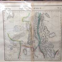
Atlas Universel De Geographie, Physique, Politique Et Mineralogique North America - Map of Eastern Nevada and Utah (Partie Du Mexique)
by Vandermaelen, Philippe
- Used
- very good
- Condition
- Used - Very Good
- Quantity Available
- 1
- Seller
-
Nashville, Tennessee, United States
- Item Price
-
NZ$847.44NZ$17.98 shipping to USA
Show Details
Description:
Brussels, Belgium: Lithographed By H. Ode. Very Good. 1827. Map. Map # 47, A Very Good primitive and early map of eastern Nevada, the State of Utah, also including part of northern Arizona and the Grand Canyon. The Great Salt Lake is shown, but further south and west than later surveyed to be. Of course, almost all localities shown are French or Indian names. Another large lake is shown, probably Bear Lake is shown in Nevada. The atlas from which this is extracted is extremely rare and originally composed 6 volumes, this map being from the North America volume. Lithographer Ode and Cartographer Vandermaelen produced the first lithographed atlas ever done. Condition is overall Very Good. Browning to the centerfold crease caused by glue used in attaching the tab to the original volume, the two page spread measures 21" x 26 1/2" when opened out. Approximately 1/3 of the map consists of a lengthy description in French of the Mexican territory which comprised Nevada and Utah. Other…
Read More Item Price
NZ$847.44
NZ$17.98
shipping to USA

Atlas Universel De Geographie, Physique, Politique Et Mineralogique North America - Map of Nova Scotia and New Brunswick (Nouvelle Ecosse Et Nouveau Brunswick)
by Vandermaelen, Philippe
- Used
- very good
- Condition
- Used - Very Good
- Quantity Available
- 1
- Seller
-
Nashville, Tennessee, United States
- Item Price
-
NZ$770.40NZ$17.98 shipping to USA
Show Details
Description:
Brussels, Belgium: Lithographed By H. Ode. Very Good. 1827. Map. Map # 44, A Very Good primitive and early map showing Nova Scotia and New Brunswick in Canada. Map has wonderful color and many small text descriptions of the coast lines. Latitude of the map is 42 degrees to 48 degrees and longitude is 60 degrees to 70 degrees. Of course, almost all localities shown are French or Indian names. The atlas from which this is extracted is extremely rare and originally composed 6 volumes, this map being from the North America volume. Lithographer Ode and Cartographer Vandermaelen produced the first lithographed atlas ever done. Condition is overall Very Good. Browning to the centerfold crease caused by glue used in attaching the tab to the original volume, the two page spread measures 21" x 26 1/2" when opened out. Topigraphical features are accentuated, see image. Shipping will require extra care and cost due to insurance. Photo available upon request. ; 21" x 26 1/2"; 1 pages .
Item Price
NZ$770.40
NZ$17.98
shipping to USA
Atlas Universel De Geographie, Physique, Politique Et Mineralogique North America - Map of Baja Peninsula and Western Coast of Mexico (Partie De La Vielle Californie)
by Vandermaelen, Philippe
- Used
- very good
- Condition
- Used - Very Good
- Quantity Available
- 1
- Seller
-
Nashville, Tennessee, United States
- Item Price
-
NZ$599.20NZ$17.98 shipping to USA
Show Details
Description:
Brussels, Belgium: Lithographed By H. Ode. Very Good. 1827. Map. Map # 58, A Very Good primitive and early map of the Baja Peninsula and the western coast of Mexico, showing the province of Sonora. Latitude of the map is 24 degrees to 30 degrees and longitude is 110 degrees to 118 degrees. Of course, almost all localities shown are French or Indian names. The atlas from which this is extracted is extremely rare and originally composed 6 volumes, this map being from the North America volume. Lithographer Ode and Cartographer Vandermaelen produced the first lithographed atlas ever done. Condition is overall Very Good. Browning to the centerfold crease caused by glue used in attaching the tab to the original volume, the two page spread measures 21" x 26 1/2" when opened out. Topigraphical features are accentuated, see image. Shipping will require extra care and cost due to insurance. Photo available upon request. ; 21" x 26 1/2"; 1 pages .
Item Price
NZ$599.20
NZ$17.98
shipping to USA
Atlas Universel De Geographie, Physique, Politique Et Mineralogique North America - Map of Southernmost Baja and Iles Revillagigedo (Partie De La Vielle Californie)
by Vandermaelen, Philippe
- Used
- very good
- Condition
- Used - Very Good
- Quantity Available
- 1
- Seller
-
Nashville, Tennessee, United States
- Item Price
-
NZ$342.40NZ$17.98 shipping to USA
Show Details
Description:
Brussels, Belgium: Lithographed By H. Ode. Very Good. 1827. Map. Map # 63, A Very Good primitive and early map of the southernmost tip of the Baja Peninsula and the Iles Revillagigedo, showing Cabo San Lucas. Latitude of the map is 18 degrees to 24 degrees and longitude is 110 degrees to 118 degrees. There is a large inset note in French about Mexico. Of course, almost all localities shown are French or Indian names. The atlas from which this is extracted is extremely rare and originally composed 6 volumes, this map being from the North America volume. Lithographer Ode and Cartographer Vandermaelen produced the first lithographed atlas ever done. Condition is overall Very Good. Browning to the centerfold crease caused by glue used in attaching the tab to the original volume, the two page spread measures 21" x 26 1/2" when opened out. Topigraphical features are accentuated, see image. Shipping will require extra care and cost due to insurance. Photo available upon request. ;…
Read More Item Price
NZ$342.40
NZ$17.98
shipping to USA
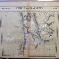
Atlas Universel De Geographie, Physique, Politique Et Mineralogique North America - Map of Western and Southern Oregon Territory (Partie Des Etats Unis)
by Vandermaelen, Philippe
- Used
- very good
- Condition
- Used - Very Good
- Quantity Available
- 1
- Seller
-
Nashville, Tennessee, United States
- Item Price
-
NZ$1,070.00NZ$17.98 shipping to USA
Show Details
Description:
Brussels, Belgium: Lithographed By H. Ode. Very Good. 1827. Map. Map # 38, A Very Good primitive and early map of western and southern Oregon territory, including southern Washington state. It especially emphasizes the coast. Latitude of the map is 42 degrees to 48 degrees and longitude is 120 degrees to 130 degrees. Of course, almost all localities shown are French or Indian names. The atlas from which this is extracted is extremely rare and originally composed 6 volumes, this map being from the North America volume. Lithographer Ode and Cartographer Vandermaelen produced the first lithographed atlas ever done. Condition is overall Very Good. Browning to the centerfold crease caused by glue used in attaching the tab to the original volume, the two page spread measures 21" x 26 1/2" when opened out. Topigraphical features are accentuated, see image. Shipping will require extra care and cost due to insurance. Photo available upon request. ; 21" x 26 1/2"; 1 pages .
Item Price
NZ$1,070.00
NZ$17.98
shipping to USA
Atlas Universel De Geographie, Physique, Politique Et Mineralogique North America - Map of the Island of Cuba (Ile De Cuba)
by Vandermaelen, Philippe
- Used
- very good
- Condition
- Used - Very Good
- Quantity Available
- 1
- Seller
-
Nashville, Tennessee, United States
- Item Price
-
NZ$407.46NZ$17.98 shipping to USA
Show Details
Description:
Brussels, Belgium: Lithographed By H. Ode. Very Good. 1827. Map. Map # 67, A Very Good primitive and early map of the Island of Cuba, also shows Jamaica and Grande Cayman. There is an inset in French with the history of Cuba. Latitude of the map is 18 degrees to 24 degrees and longitude is 78 degrees to 86 degrees. Of course, almost all localities shown are French or Indian names. The atlas from which this is extracted is extremely rare and originally composed 6 volumes, this map being from the North America volume. Lithographer Ode and Cartographer Vandermaelen produced the first lithographed atlas ever done. Condition is overall Very Good. Browning to the centerfold crease caused by glue used in attaching the tab to the original volume, the two page spread measures 21" x 26 1/2" when opened out. Topigraphical features are accentuated, see image. Shipping will require extra care and cost due to insurance. Photo available upon request. ; 21" x 26 1/2"; 1 pages .
Item Price
NZ$407.46
NZ$17.98
shipping to USA
Atlas Universel De Geographie, Physique, Politique Et Mineralogique North America - Map of the Southwest Mexico Coastline (Partie Du Mexique)
by Vandermaelen, Philippe
- Used
- very good
- Condition
- Used - Very Good
- Quantity Available
- 1
- Seller
-
Nashville, Tennessee, United States
- Item Price
-
NZ$513.60NZ$17.98 shipping to USA
Show Details
Description:
Brussels, Belgium: Lithographed By H. Ode. Very Good. 1827. Map. Map # 70, A Very Good primitive and early map showing the southwest Mexico coastline with portions of Guerrrero Province. Includes Acapulco. Has nice multi-color contrasts also includes a large geological diagramatic illustration. Map is based on the excursion of nautralist Alexander Humboldt in 1802. Latitude of the map is 15 degrees to 18 degrees and longitude is 100 degrees to 108 degrees. Of course, almost all localities shown are French or Indian names. The atlas from which this is extracted is extremely rare and originally composed 6 volumes, this map being from the North America volume. Lithographer Ode and Cartographer Vandermaelen produced the first lithographed atlas ever done. Condition is overall Very Good. Browning to the centerfold crease caused by glue used in attaching the tab to the original volume, the two page spread measures 21" x 26 1/2" when opened out. Topigraphical features are accentuated,…
Read More Item Price
NZ$513.60
NZ$17.98
shipping to USA
Atlas Universel De Geographie, Physique, Politique Et Mineralogique North America - Map of the North Hampton Bay Area (Ile Southampton)
by Vandermaelen, Philippe
- Used
- very good
- Condition
- Used - Very Good
- Quantity Available
- 1
- Seller
-
Nashville, Tennessee, United States
- Item Price
-
NZ$470.80NZ$17.98 shipping to USA
Show Details
Description:
Brussels, Belgium: Lithographed By H. Ode. Very Good. 1827. Map. Map # 17, A Very Good primitive and early map showing the North Hampton Bay area. Includes the Welcome Strait. Latitude of the map is 60 degrees to 66degrees and longitude is 82 degrees to 98 degrees. Of course, almost all localities shown are French or Indian names. The atlas from which this is extracted is extremely rare and originally composed 6 volumes, this map being from the North America volume. Lithographer Ode and Cartographer Vandermaelen produced the first lithographed atlas ever done. Condition is overall Very Good. Browning to the centerfold crease caused by glue used in attaching the tab to the original volume, the two page spread measures 21" x 26 1/2" when opened out. Topigraphical features are accentuated, see image. Shipping will require extra care and cost due to insurance. Photo available upon request. ; 21" x 26 1/2"; 1 pages .
Item Price
NZ$470.80
NZ$17.98
shipping to USA
Atlas Universel De Geographie, Physique, Politique Et Mineralogique North America - Map of the Lesser Antilles (Petites Antilles)
by Vandermaelen, Philippe
- Used
- very good
- Condition
- Used - Very Good
- Quantity Available
- 1
- Seller
-
Nashville, Tennessee, United States
- Item Price
-
NZ$684.80NZ$17.98 shipping to USA
Show Details
Description:
Brussels, Belgium: Lithographed By H. Ode. Very Good. 1827. Map. Map # 75, A Very Good primitive and early map showing the lesser Antilles, shows St. Croix on the north and Grenada on the south. Includes the island of St. Croix, St. Bartholome, St Christophe-Nevis, Antigue, Barbude, Guadeloupe, Dominica, Martinque, St. Lucia, Grenade, Barbados and others. Very nice color contrasts. Latitude of the map is 12 degrees to 18 degrees and longitude is 60 degrees to 68 degrees. Of course, almost all localities shown are French or Indian names. The atlas from which this is extracted is extremely rare and originally composed 6 volumes, this map being from the North America volume. Lithographer Ode and Cartographer Vandermaelen produced the first lithographed atlas ever done. Condition is overall Very Good. Browning to the centerfold crease caused by glue used in attaching the tab to the original volume, the two page spread measures 21" x 26 1/2" when opened out. Topigraphical features are…
Read More Item Price
NZ$684.80
NZ$17.98
shipping to USA
Atlas Universel De Geographie, Physique, Politique Et Mineralogique North America - Map of Southern California Coast
by Vandermaelen, Philippe
- Used
- very good
- Condition
- Used - Very Good
- Quantity Available
- 1
- Seller
-
Nashville, Tennessee, United States
- Item Price
-
NZ$1,241.20NZ$17.98 shipping to USA
Show Details
Description:
Brussels, Belgium: Lithographed By H. Ode. Very Good. 1827. Map. Map # 53, A Very Good primitive and early map showing the southern California coast with San Diego and others. Map has wonderful color and many small text descriptions of the coast lines. Latitude of the map is 30 degrees to 36 degrees and longitude is 112 degrees to 120 degrees. Of course, almost all localities shown are French or Indian names. The atlas from which this is extracted is extremely rare and originally composed 6 volumes, this map being from the North America volume. Lithographer Ode and Cartographer Vandermaelen produced the first lithographed atlas ever done. Condition is overall Very Good. Browning to the centerfold crease caused by glue used in attaching the tab to the original volume, the two page spread measures 21" x 26 1/2" when opened out. Topigraphical features are accentuated, see image. Shipping will require extra care and cost due to insurance. Photo available upon request. ; 21" x 26…
Read More Item Price
NZ$1,241.20
NZ$17.98
shipping to USA

Didn’t find what you’re looking for?
Try adding this search to your want list. Millions of books are added to our site everyday and when we find one that matches your search, we’ll send you an email. Best of all, it’s free.
Add to Want List

Are you a frequent reader or book collector?
Join the Bibliophile's Club and save 10% on every purchase, every day — up to $20 savings per order!

Social Responsibility
Did you know that since 2004, Biblio has used its profits to build 16 public libraries in rural villages of South America?
