Description:
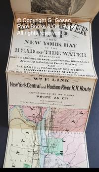
Link, William F. The Hudson River Map from New York Bay to the Head of the Tide W Containing Names of Streams, Islands and Heights of Mountains According to the latest Coast Survey, Also the Names of Prominent Residences, Historic Land Marks, the Reaches of the Hudson and Old Indian Names. Published by Wm. F. Link. New York Central and Hudson River R.R. Route. Copyrighted by Wm. F. Link. Price 25 Cts. [1886] Bound with The Hudson River Map Via the New York Central & Hudson R. R.. What the Traveler Wishes to See and Know. New York: Published by Bryant Literary Union, Evening Post Building. [n.d.] 8 pages, numbered on the recto only, a circular vignette on the title page, with eight woodcut illustrations on the verso of each page. Page two is a list of stations and distances from New York to Albany and from Albany to Buffalo. A strip map, in hand-colored lithography, 272 cm x 14.5 cm, bound in a thick brown paper wrapper with an oval vignette of the Hudson River showing river steamers, sailboats and a…
Read More Search Results: Maps from G.Gosen Rare Books & Old Paper, ABAA, ILAB
You searched for:
- Subject: Maps from G.Gosen Rare Books & Old Paper, ABAA, ILAB
Results 1 - 2 of 2
More Photos
The Hudson River Map from New York Bay to the Head of the Tide W Containing Names of Streams, Islands and Heights of Mountains According to the latest Coast Survey, Also the Names of Prominent Residences, Historic Land Marks, the Reaches of the Hudson and Old Indian Names.: Published by Wm. F. Link. New York Central and Hudson River R.R. Route. Copyrighted by Wm. F. Link. Price 25 Cts.
by Link, William F.
- Used
- first
- Condition
- Used
- Quantity Available
- 1
- Seller
-
New York, New York, United States
- Item Price
-
NZ$1,462.85NZ$34.42 shipping to USA
Show Details
Item Price
NZ$1,462.85
NZ$34.42
shipping to USA

More Photos
RAILWAY MAP LONDON UNDERGROUND TRANSPORT, 1934, No. 2. ISSUED FREE.
by Beck, H. C.
- Used
- first
- Condition
- Used
- Quantity Available
- 1
- Seller
-
New York, New York, United States
- Item Price
-
NZ$645.38NZ$34.42 shipping to USA
Show Details
Description:
[London. Underground] H. C. Beck, Henry Charles Beck, RAILWAY MAP LONDON UNDERGROUND TRANSPORT, 1934, No. 2. ISSUED FREE. Printed by Johnson Riddle & Co. for London Transport, 55 Broadway, Westminster, S.W.I, Victoria 6800. Signed in lower left-hand corner below the reference, "H. C. Beck." This 1934 underground railroad pocket map was issued just one year after Henry Charles Beck's revolutionary railroad map design made its first appearance in 1933. Beck's first design maps ran from 1933 to 1938. On the back, verso, are listed Places of Interest and Theatres, a feature replaced with a schematic design map of Interchange Stations Central Area on subsequent maps in Beck's first series design. 14.5 cm x 25.8 cm. This map's blue border was trimmed slightly to fit into a pocket diary, where it was preserved in good condition.
Item Price
NZ$645.38
NZ$34.42
shipping to USA

Didn’t find what you’re looking for?
Try adding this search to your want list. Millions of books are added to our site everyday and when we find one that matches your search, we’ll send you an email. Best of all, it’s free.
Add to Want List

Are you a frequent reader or book collector?
Join the Bibliophile's Club and save 10% on every purchase, every day — up to $20 savings per order!

Social Responsibility
Did you know that since 2004, Biblio has used its profits to build 16 public libraries in rural villages of South America?
