Description:
London: MINISTRy of Agriculture Fisheries and Food, 1981. Book. Near Fine. Hardcover. First Edition. Folio. unpaginated, colour and b/w maps Original hardback binding, spiral bound, fine with minimal wear. Contents clean and tight, small water mark to the endpaper, no inscriptions. A near fine copy..
Search Results: Atlases and Maps from Loe Books
You searched for:
- Subject: Atlases and Maps from Loe Books
Results 1 - 20 of 26

Atlas of the Seas Around the British Isles
by Directorate of Fisheries Research
- Used
- near fine
- Hardcover
- first
- Condition
- Used - Near Fine
- Edition
- First Edition
- Binding
- Hardcover
- ISBN 10 / ISBN 13
- 9780907545002 / 0907545009
- Quantity Available
- 1
- Seller
-
Launceston, Cornwall, United Kingdom
- Item Price
-
NZ$42.47NZ$31.85 shipping to USA
Show Details
Item Price
NZ$42.47
NZ$31.85
shipping to USA

BELGIE IN VOGELVLUCHT GEZIEN 1915 VUE DE LA BELGIQUE A VOL D'OISEAU
by A. Van Opstraet, (Uitgever; Editeur)
- Used
- good
- first
- Condition
- Used - Good
- Edition
- First Edition
- Quantity Available
- 1
- Seller
-
Launceston, Cornwall, United Kingdom
- Item Price
-
NZ$101.93NZ$31.85 shipping to USA
Show Details
Description:
Antwerpen: Willem Seghers, Litho-Grav., 1915. Book. Good. Map. First Edition. 120x86cm. A substantial map 120 x 86cm, colour printed in two halves and joined on the back. A few edge tears and a few splits to the central folds, a couple of splits repaired to the verso with paper tape, several light creases. A good copy. Seemingly scarce..
Item Price
NZ$101.93
NZ$31.85
shipping to USA

More Photos
CARTE DE ROYAUME DE FRANCE Divisee En 86 Departmens Comprenant Les Chefs lieux, Les Sous Prefectures et Les Chefs Lieux De Cantons
- Used
- Fine
- Hardcover
- Condition
- Used - Fine
- Binding
- Hardcover
- Quantity Available
- 1
- Seller
-
Launceston, Cornwall, United Kingdom
- Item Price
-
NZ$95.56NZ$31.85 shipping to USA
Show Details
Description:
Paris - 21 Quai Voltaire: Rosselin, 1830. Book. Fine. Map. A fine map hand-coloured in outline, folding into original marbled paper boards with title label to the front board. Boards rubbed conrners worn. The map measures 74 x 55cm and is in very good condition with the paper bright. A very good to fine copy of this rare map..
Item Price
NZ$95.56
NZ$31.85
shipping to USA
COLLINS-LONGMANS STUDY ATLAS
by Huggins, K. H. Et al
- Used
- very good
- Hardcover
- Condition
- Used - Very Good
- Edition
- Fifteenth Edition
- Binding
- Hardcover
- Quantity Available
- 1
- Seller
-
Launceston, Cornwall, United Kingdom
- Item Price
-
NZ$21.24NZ$31.85 shipping to USA
Show Details
Description:
London, 1965. Book. Very Good. Hardcover. Fifteenth Edition. 4to. Fifteenth Edition with Colour photograph, colour maps throughout. Dust jacket good with some general wear, and some chipping and associated creasing to edges, 3cm missing from top of spine, now protected in an archival sleeve and looks good. Original red cloth binding with gilt lettering, excellent having been protected by the dust jacket. Contents clean and tight. A very good copy in a good dust jacket..
Item Price
NZ$21.24
NZ$31.85
shipping to USA
More Photos
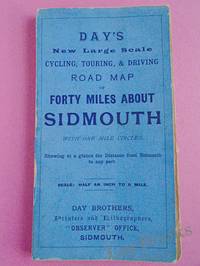
DAY'S NEW LARGE SCALE CYCLING, TOURING & DRIVING ROAD MAP OF FORTY MILES ABOUT SIDMOUTH With One Mile Circles Showing at a Glance the Distance from Sidmouth to any Part
by Day Brothers
- Used
- very good
- Paperback
- Condition
- Used - Very Good
- Edition
- New Edition
- Binding
- Paperback
- Quantity Available
- 1
- Seller
-
Launceston, Cornwall, United Kingdom
- Item Price
-
NZ$101.93NZ$31.85 shipping to USA
Show Details
Description:
Sidmouth: Day Brothers, 1900. Map. Very Good. Soft cover. New Edition. Undated, but circa 1900? Engraved map, main roads coloured orange, 445 x 575 mm, folding down to 150 x 85 mm, with printed blue covers, published by Day Brothers "Printers, Stationers & Booksellers, Observer Office, Sidmouth". Generally in very good condition with light general wear and some rubbing to edges of covers. An attractive map. Scarce..
Item Price
NZ$101.93
NZ$31.85
shipping to USA
FOUR CENTURIES OF LIVERPOOL The Growth of a City A Collection of Maps and Views
by Spiegl, Fritz
- Used
- very good
- Paperback
- Condition
- Used - Very Good
- Edition
- 2nd Printing
- Binding
- Paperback
- Quantity Available
- 1
- Seller
-
Launceston, Cornwall, United Kingdom
- Item Price
-
NZ$74.33NZ$31.85 shipping to USA
Show Details
Description:
Liverpool: Scouse Press, 1970. Book. Very Good. Paperback. 2nd Printing. 4to. This is the revised "Liverpool Packet No. 2" with the additional maps. Numerous maps and plans - all present and correct- checked against contents list, some colour and many folding, printed on different colour papers, historical notes also present. In original plastic wallet which is a little worn and marked. The title page is faded and has a number written to the reverse, otherwise no other marks or inscriptions to maps or notes. Some maps with small creases to corners and some a little browned along edges. A good to very set..
Item Price
NZ$74.33
NZ$31.85
shipping to USA
FOUR LARGE, COLOUR MAPS OF RHUM: North West, North East, South West and South East. Scale 1:10,000
- Used
- very good
- first
- Condition
- Used - Very Good
- Edition
- First Edition
- Quantity Available
- 1
- Seller
-
Launceston, Cornwall, United Kingdom
- Item Price
-
NZ$59.46NZ$31.85 shipping to USA
Show Details
Description:
Glasgow: Nature Conservancy/University of Glasgow, 1972. Map. Very Good. No Binding. First Edition. 77 x 78 Cm. "Produced in the Department of Geography, University of Glasgow, on behalf of the Nature Conservancy. Printed by J. Bartholomew and Son Ltd., Edinburgh" Each map approximately 77 x 78 cm. These maps have been kept in a tube probably since published and have a little wear to edges and from being unrolled, but are essentially in very good condition. Scarce..
Item Price
NZ$59.46
NZ$31.85
shipping to USA
GEOGRAPHERS' STANDARD MAP OF ENGLAND AND WALES
by Gross, Alexander
- Used
- very good
- Hardcover
- Condition
- Used - Very Good
- Binding
- Hardcover
- Quantity Available
- 1
- Seller
-
Launceston, Cornwall, United Kingdom
- Item Price
-
NZ$42.47NZ$31.85 shipping to USA
Show Details
Description:
London: Geographers' Map Co Ltd. Map/Print. Very Good. Map. No date. Circa 1950. Very large colour linen-backed map (approximately 102 x 136cm) dissected into 25 sections, folding into green cloth-backed boards. In very good condiion, boards with a little wear to spine, map very good, map excellent, clean, paper slightly toned. Bookplate of The Iron and Steel Institute, The Institute of Metals to inside front board - dated Jan 1953 - cost of map £1 15s, single stamp of the same to the rear of the map. A very good copy of this excellent map. 0.
Item Price
NZ$42.47
NZ$31.85
shipping to USA
HARDENDALE FELL; WESTMORLAND SHEET XIV. 14. - Very Large Ordnance Survey Map 1898; Scale 1:2500
- Used
- very good
- Condition
- Used - Very Good
- Edition
- Second Edition
- Quantity Available
- 1
- Seller
-
Launceston, Cornwall, United Kingdom
- Item Price
-
NZ$63.71NZ$31.85 shipping to USA
Show Details
Description:
Southampton: Ordnance Survey, 1898. Map/Print. Very Good. Unframed. Second Edition. A very large original map measuring 104 x 136cm, 64 sections dissected onto a linen backing; folding into original brown covers, the upper with a label of Edward Stanford, Ltd, London. A very good copy in very good condition..
Item Price
NZ$63.71
NZ$31.85
shipping to USA
INDICATEUR EXACT DES RUES DE PARIS 1919
by Anon
- Used
- good
- Paperback
- Condition
- Used - Good
- Binding
- Paperback
- Quantity Available
- 1
- Seller
-
Launceston, Cornwall, United Kingdom
- Item Price
-
NZ$14.87NZ$31.85 shipping to USA
Show Details
Description:
Paris: Thibault Fils, 1919. Book. Good. Paperback. 24mo (8 x 12cm). Title page reads "NOUVEAU GUIDE DES RUES DE PARIS" 92 pages. Original red card covers with silver gilt lettering, good with some general wear and rubbing, a little marked. Contents good, some pages creased at edges. A good copy..
Item Price
NZ$14.87
NZ$31.85
shipping to USA

THE ISLAND OF SUMATRA (ORIGINAL COLOUR MAP)
by No Author
- Used
- very good
- Condition
- Used - Very Good
- Quantity Available
- 1
- Seller
-
Launceston, Cornwall, United Kingdom
- Item Price
-
NZ$16.99NZ$31.85 shipping to USA
Show Details
Description:
London: Edward Stanford Map. Very Good. Map. No date but circa 1910. A fine coloured map of the island of Sumatra measuing 19. x 32.5cm. Originally from an atlas with 3 fold lines. Very good condition..
Item Price
NZ$16.99
NZ$31.85
shipping to USA

Karte Nr. 35. Ravenstein's Rad- u. Automobil-Karte für den Regierungsbezirk LIEGNITZ Sowie Die Umgend Von Gorlitz Und Zittau. 1: 300 000.
by n/a
- Used
- very good
- Hardcover
- Condition
- Used - Very Good
- Binding
- Hardcover
- Quantity Available
- 1
- Seller
-
Launceston, Cornwall, United Kingdom
- Item Price
-
NZ$31.85NZ$31.85 shipping to USA
Show Details
Description:
Frankfurt: Ludwig Ravenstein Book. Very Good. Map. No date circa 1910? Cloth backed coloured map - approximately 80 x 60cm. In very good condition, some - towns underlined in blue. A very good copy..
Item Price
NZ$31.85
NZ$31.85
shipping to USA
LAVOISNE'S COMPLETE GENEALOGICAL, HISTORICAL, CHRONOLOGICAL AND GEOGRAPHICAL ATLAS
by Lavoisne (C.V.).
- Used
- very good
- Hardcover
- Condition
- Used - Very Good
- Edition
- Fourth Edition
- Binding
- Hardcover
- Quantity Available
- 1
- Seller
-
Launceston, Cornwall, United Kingdom
- Item Price
-
NZ$2,548.32NZ$31.85 shipping to USA
Show Details
Description:
London: Printed and Published By J. Barfield, 1840. Book. Very Good. Hardcover. Fourth Edition. Folio (30 x 46cm). "Revised, Collated and Considerably Enlarged by John Satchell Esq." Seventy-four double-page engraved genealogical tables and geographical maps all with original hand colouring, contemporary . half black morocco gilt, with green cloth boards. Binding good with some general wear and rubbing, leather chipped with loss to the base of the spine, joints rubbed but still strong, corners worn. All edges gilt./ Contents clean and tight, contemporary ink stain effecting the fore-edges of the first few pages, but not affecting text or maps, most noticeable to the front end papers with also have a pencil inscription dated 30 November 1935. All maps and charts in very good condition. Notwitstanding wear to the binding a very good copy..
Item Price
NZ$2,548.32
NZ$31.85
shipping to USA

More Photos
MAP OF ENVIRONS OF MANSFIELD
- Used
- very good
- Condition
- Used - Very Good
- Quantity Available
- 1
- Seller
-
Launceston, Cornwall, United Kingdom
- Item Price
-
NZ$31.85NZ$31.85 shipping to USA
Show Details
Description:
Nottingham: Roberts & Co., 1900. Map. Very Good. Map. Not dated but c. 1900. Approximately 37 x 47cm, folding down into printed paper covers. Map printed in black, red and green. Generally very good a few short splits at folds of creases. A rare locally published map..
Item Price
NZ$31.85
NZ$31.85
shipping to USA
THE NEW BIBLICAL ATLAS AND SCRIPTURE GAZETTEER WITH DESCRIPTIVE NOTICES OF THE TABERNACLE AND THE TEMPLE
by Anon
- Used
- very good
- Hardcover
- first
- Condition
- Used - Very Good
- Edition
- First Edition
- Binding
- Hardcover
- Quantity Available
- 1
- Seller
-
Launceston, Cornwall, United Kingdom
- Item Price
-
NZ$148.65NZ$31.85 shipping to USA
Show Details
Description:
London: The Religious Tract Society, 1852. Book. Very Good. Hardcover. First Edition. 4to (19 x 28cm). Maps dated 1852 and signature to front endpaper also dated 1852; pp. [4], 96, 12 hand-coloured maps/plates of which 2 are folding. Original brown cloth binding with gilt lettering, good to very good with a little general wear and rubbing to extremities, cloth slightly marked and chipped to head/tail of the spine, with 3cm loss to the bottom. All edges gilt. Contents clean and tight, small inconspicuous stain/mark to lower edge of first pages, a little reading wear, all maps good, later bookplate to front fre endpaper. A good very good tight copy..
Item Price
NZ$148.65
NZ$31.85
shipping to USA
PHILIPS JUNIOR HISTORICAL ATLAS Prepared Under the Direction of the Historical Association
by Not Cited
- Used
- very good
- Paperback
- Condition
- Used - Very Good
- Edition
- Fifth Edition
- Binding
- Paperback
- Quantity Available
- 1
- Seller
-
Launceston, Cornwall, United Kingdom
- Item Price
-
NZ$21.24NZ$31.85 shipping to USA
Show Details
Description:
London: George Philip & Son Limited, 1929. Book. Very Good. Paperback. Fifth Edition. 4to. 40 colour maps. Cloth backed card covers, good with some general wear, a little grubby. Contents tight, some general reading wear and finger marks, title page somewhat marked with a small scuff mark. A good to very good copy..
Item Price
NZ$21.24
NZ$31.85
shipping to USA

More Photos
PHILIPS HANDY GENERAL CENTENARY ATLAS OF THE WORLD
by Philip, George, F.R.G.S. (editor)
- Used
- very good
- Hardcover
- Condition
- Used - Very Good
- Edition
- Fourth and Enlarged Edition
- Binding
- Hardcover
- Quantity Available
- 1
- Seller
-
Launceston, Cornwall, United Kingdom
- Item Price
-
NZ$254.83NZ$31.85 shipping to USA
Show Details
Description:
London: George Philip & son, Ltd, 1934. Book. Very Good. Hardcover. Fourth and Enlarged Edition. Folio 40 x 28 cm. "A Series of 232 pages of coloured maps and plans forming a complete, geographical survey of the international relationships of the new era, its territorial changes and commercial communications...with an index of over 116,000 names". 116 double-page colour maps, the atlas divided into continents with thumb tabs for each. Loosely inserted is the original colour advertising flyer/poster for this atlas; this is the haf leather edition with gilt lettering and gilt edges to the top of the pages (it was also available in cheaper cloth). Binding very good with slight rubbing to edges, cloth to rear board a little mottled. Contents clean and tight, original marbled endpapers, no inscriptions, maps all present and in very good condition. An impressive atlas. Please note this item is very heavy and small postal surcharge is likely to apply..
Item Price
NZ$254.83
NZ$31.85
shipping to USA

Road Map (scale: 3 Miles to 1 inch) for Motoring, Cycling and Hiking: Section LL (Exeter, Torquay, Plymouth, Dartmoor, Barnstaple Etc.)
by No Author
- Used
- very good
- Paperback
- Condition
- Used - Very Good
- Binding
- Paperback
- Quantity Available
- 1
- Seller
-
Launceston, Cornwall, United Kingdom
- Item Price
-
NZ$21.24NZ$31.85 shipping to USA
Show Details
Description:
W. & A. K. Johnston Ltd, 1949. Book. Very Good. Paperback. code 12/49 presumed to be December 1949. Large colour printed map folding down into pictorial card covers printed in red and green. Covers very good with light wear only. Map clean and bright, no annotations or inscriptions, a single 1cm split at central folding otherwise very light wear. A very good copy..
Item Price
NZ$21.24
NZ$31.85
shipping to USA
SCHOOL GEOGRAPHY
by Clyde, James
- Used
- very good
- Hardcover
- Condition
- Used - Very Good
- Edition
- Twenty-third Edition
- Binding
- Hardcover
- Quantity Available
- 1
- Seller
-
Launceston, Cornwall, United Kingdom
- Item Price
-
NZ$42.47NZ$31.85 shipping to USA
Show Details
Description:
Edinburgh: Oliver and Boyd, 1886. Book. Very Good. Hardcover. Twenty-third Edition. 8vo (12 X 18cm). "Revised throughout and partly recast. With Nine Maps" pp. 551 + 24 pages of adverts, 9 colour folding maps. Original brown cloth binding with gilt lettering, very good and bright with slight wear only. Contents clean and tight, small neat signature dated 16.10.87 to front end paper otherwise no inscriptions. A very good to fine copy..
Item Price
NZ$42.47
NZ$31.85
shipping to USA

SMALL HAND-COLOURED MAP OF ASIA (1795)
by Not Appropriate
- Used
- very good
- Condition
- Used - Very Good
- Edition
- Second Edition
- Quantity Available
- 1
- Seller
-
Launceston, Cornwall, United Kingdom
- Item Price
-
NZ$38.22NZ$31.85 shipping to USA
Show Details
Description:
London: W. Peacock, 1795. Book. Very Good. n/a. Second Edition. an original small copper-engraved map of Africa (approximately 170 x 127mm) hand-coloured in outline, as one of the maps that appeared in the second edition of "A Compendious Geographical Dictionary..." published in 1795 by W. Peacock in London. Condition is generally very good; the map was folded within the book so there are a couple of fold lines. An attractive little item..
Item Price
NZ$38.22
NZ$31.85
shipping to USA

Didn’t find what you’re looking for?
Try adding this search to your want list. Millions of books are added to our site everyday and when we find one that matches your search, we’ll send you an email. Best of all, it’s free.
Add to Want List

Are you a frequent reader or book collector?
Join the Bibliophile's Club and save 10% on every purchase, every day — up to $20 savings per order!

Social Responsibility
Did you know that since 2004, Biblio has used its profits to build 16 public libraries in rural villages of South America?
