Description:
Burr. NEAR FINE map. Map #49 from Burr's 1829 New York State Atlas.. 1829. 1st edition. Hardcover. NEAR FINE map. Hand colored in shades of olive, light green & light pink. 15.5"x12.75" @ plate marks. Overall 20"x16" . Engraved by Rawdon, Clark of Albany & Rawdon, Wright of N York. Plate marks 15.5"x12.75", map about 2" less in both dimensions. Few spots or areas of light aging, foxing or soiling. BUT: verso heavily browned, likely from contact with acidic matt paper. This browning is not focing and is only on verso. In 1829 the Erie Canal had been open for less than ten years. About half the lots are numbered and their owners can be identified. No individual houses are marked. There are a half dozen symbols for mills, churches, etc. From Burr's "ATLAS of the STATE of NEW YORK", just the 2nd atlas of an American state. Burr was a protege of Simeon De Witt, George Washington's chief map maker. After the Revolutionary War De Witt was NYS…
Read More Search Results: New York from Quiet Friends
You searched for:
- Subject: New York from Quiet Friends
Results 1 - 1 of 1
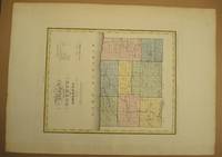
MAP of the COUNTY of ORLEANS by David H Burr
by Burr, David maps&prints
- Used
- Hardcover
- first
- Condition
- NEAR FINE map. Map #49 from Burr's 1829 New York State Atlas.
- Edition
- 1st edition
- Binding
- Hardcover
- Quantity Available
- 1
- Seller
-
Lyndonville, New York, United States
- Item Price
-
NZ$344.20NZ$5.16 shipping to USA
Show Details
Item Price
NZ$344.20
NZ$5.16
shipping to USA

Didn’t find what you’re looking for?
Try adding this search to your want list. Millions of books are added to our site everyday and when we find one that matches your search, we’ll send you an email. Best of all, it’s free.
Add to Want List

Are you a frequent reader or book collector?
Join the Bibliophile's Club and save 10% on every purchase, every day — up to $20 savings per order!

Social Responsibility
Did you know that since 2004, Biblio has used its profits to build 16 public libraries in rural villages of South America?
