Description:
[London]: [John and Paul Knapton], 1745. Print. Very Good. Matted and ready for framing. Evidence of three folds, left side trimmed. 1745 Print. A 1745 map with scale and compass, taken from Tindal & Rapin's History of England, which was published from 1743-1747. Ypres was an important fortress and trade location from the Middle Ages through World War I. The print depicts the star shaped fortifications typical to most fortifications of the time, which were designed to accommodate defensive canonry and defend against artillery sieges. The waterways in the map and several of the hornworks within the natural moat are labeled, and the arrangement of streets within the fortification is well demarcated.
Search Results: Ephemera from Yesterday's Muse Books
You searched for:
- Subject: Ephemera from Yesterday's Muse Books
Results 1 - 20 of 27
![1745 Map: Ypres a strong City and Castle in Flanders [Belgium], restor'd to the Emperor by...](https://d3525k1ryd2155.cloudfront.net/h/910/205/477205910.0.m.1.jpg)
1745 Map: Ypres a strong City and Castle in Flanders [Belgium], restor'd to the Emperor by the Treaty of Utrecht, For Mr. Tindal's Continuation of Mr. Rapin's History of England
by [Tindal, Nicolas] [De Thoyras, Rapin]
- Used
- very good
- Condition
- Used - Very Good
- Quantity Available
- 1
- Seller
-
Webster, New York, United States
- Item Price
-
NZ$128.60NZ$10.61 shipping to USA
Show Details
Item Price
NZ$128.60
NZ$10.61
shipping to USA

1747 Map and Plan from Prevost's 'Histoire Generale des Voyages': Plan du Fort St Joseph with Two Maps
by [Prevost]
- Used
- near fine
- Condition
- Used - Near Fine
- Quantity Available
- 1
- Seller
-
Webster, New York, United States
- Item Price
-
NZ$68.58NZ$10.61 shipping to USA
Show Details
Description:
[A La Haye : Chez Pierre de Hondt], 1747. Print. Near Fine. Matted and reading for framing. An exceptional example. 1747 Print. Matted to 9 1/2 x 7 (mat measures 11 5/8 x 9). Labeled Tome II. No. 23, indicating position in the original work. French text A birds'-eye plan of Fort St Joseph complete with scale, together with a map of its location along the Senegal River, and a map showing the position of Fort St Louis on an island mid-river. Several settlements are also indicated (Korinkani, Bubemusa, Mankanet). The fort plan is fairly simple, with a curtain wall with two corner bastions surrounding magazines, a large common room, and a room at the rear of the fortress for storing slaves.
Item Price
NZ$68.58
NZ$10.61
shipping to USA
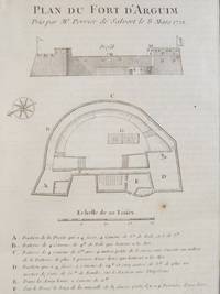
1747 Plan from Prevost's 'Histoire Generale des Voyages': Plan du Fort Fort D'Arguim Pris par Mr. Perrier de Salvert le S Mars 1721
by [Prevost]
- Used
- very good
- Condition
- Used - Very Good
- Quantity Available
- 1
- Seller
-
Webster, New York, United States
- Item Price
-
NZ$68.58NZ$10.61 shipping to USA
Show Details
Description:
[A La Haye : Chez Pierre de Hondt], 1747. Print. Very Good. Matted and reading for framing. One tiny foxed spot in blank space beneath plate, some faint transfer from opposite text page. 1747 Print. Matted to 9 1/2 x 7 (mat measures 11 5/8 x 9). Labeled Tome II. No. 16, indicating position in the original work. French text. A combined birds'-eye and profile view of the fort complete with scale and compass. A key beneath labels the salient features, which give great detail about the quantity and size of the canonry in each location, most interestingly a section labeled 'Sur le Fosse le long de la muraille de la fausse porte il y a 4 Pierriers d'une livre'.
Item Price
NZ$68.58
NZ$10.61
shipping to USA

1747 Plan from Prevost's 'Histoire Generale des Voyages': Plan du Fort Anglois de Sukonda, Situe a la Coste de Guinee par 4. Deg. 32. Min. de Latitude
by [Prevost]
- Used
- near fine
- Condition
- Used - Near Fine
- Quantity Available
- 1
- Seller
-
Webster, New York, United States
- Item Price
-
NZ$68.58NZ$10.61 shipping to USA
Show Details
Description:
[A La Haye : Chez Pierre de Hondt], 1747. Print. Near Fine. Matted and ready for framing. An exceptional example. 1747 Print. Matted to 9 x 6 3/4 (mat measures 11 5/8 x 9). Labeled Tome IV. No. 3, indicating position in the original work. French text. A birds'-eye view, complete with scale and latitudinal coordinates, of a fairly simple fortification, rectangular with two diamond bastions on the eastern corners. Numerous batteries for canonry, and an interior structure consisting of several apartments, a common room and a powder magazine.
Item Price
NZ$68.58
NZ$10.61
shipping to USA

1747 Plan from Prevost's 'Histoire Generale des Voyages': Plan du Fort Anglois de Dickscove, Situe a la Coste de Guinee
by [Prevost]
- Used
- near fine
- Condition
- Used - Near Fine
- Quantity Available
- 1
- Seller
-
Webster, New York, United States
- Item Price
-
NZ$68.58NZ$10.61 shipping to USA
Show Details
Description:
[A La Haye : Chez Pierre de Hondt], 1747. Print. Near Fine. Matted and reading for framing. An exceptional example. 1747 Print. Matted to 9 1/2 x 7 (mat measures 11 5/8 x 9). Labeled Tome IV. No. 2, indicating position in the original work. French text. A birds'-eye view of the fort complete with scale and compass. A fairly modern structure, with three diamond-shaped bastions, a circular southeastern tower, and a large spur protruding to the south, designed to provide extra defense to the main gate. Batteries line the east wall and the western bastions - there are none on the main western and northern wall sections.
Item Price
NZ$68.58
NZ$10.61
shipping to USA

1747 Plan from Prevost's 'Histoire Generale des Voyages': Plan du Fort Hollandois de Sama nomme St Sebastien, Situe a la Coste de Guinee par les 4 Deg. 35 mins. de Latitude
by [Prevost]
- Used
- near fine
- Condition
- Used - Near Fine
- Quantity Available
- 1
- Seller
-
Webster, New York, United States
- Item Price
-
NZ$68.58NZ$10.61 shipping to USA
Show Details
Description:
[A La Haye : Chez Pierre de Hondt], 1747. Print. Near Fine. Matted and reading for framing. An exceptional example. 1747 Print. Matted to 9 1/2 x 7 (mat measures 11 5/8 x 9). Labeled Tome IV. No. 4, indicating position in the original work. French text. A birds'-eye view of the fort complete with scale and latitudinal coordinates. This is a fairly complex fort, comparatively, with a structure of numerous apartments and barracks, a magazine, a court and a chapel, defended by an array of three towers and two large bastions (interestingly labeled as 'Eperon' and 'Pointe de la Montagne Verte' on this plan). The fort is flanked on two sides by water, and numerous batteries for canonry line these walls, and also the north wall.
Item Price
NZ$68.58
NZ$10.61
shipping to USA

1747 Plan from Prevost's 'Histoire Generale des Voyages': Plan du Fort Anglois de Juida, ou Fort Williams
by [Prevost]
- Used
- near fine
- Condition
- Used - Near Fine
- Quantity Available
- 1
- Seller
-
Webster, New York, United States
- Item Price
-
NZ$68.58NZ$10.61 shipping to USA
Show Details
Description:
[A La Haye : Chez Pierre de Hondt], 1747. Print. Near Fine. Matted and reading for framing. Light rub to double ruled border. An exceptional example. 1747 Print. Matted to 9 1/2 x 7 (mat measures 11 5/8 x 9). Labeled Tome IV. No. 11, indicating position in the original work. French text. A birds'-eye view of the fort complete with scale and compass. Three corners are diamond-shaped bastions, with a circular tower on the northwest. The structure is surrounded by a dry moat (labeled 'fosse'), and the rear section of the fortress is labeled 'Lieu ou se tiennent les Negres'.
Item Price
NZ$68.58
NZ$10.61
shipping to USA

1747 Plan from Prevost's 'Histoire Generale des Voyages': Plan du Fort Anglois et de la Ville du Cap de Corse, Situe a la Coste de Guinee par 4. Degres 50. Minutes de Latitude
by [Prevost]
- Used
- near fine
- Condition
- Used - Near Fine
- Quantity Available
- 1
- Seller
-
Webster, New York, United States
- Item Price
-
NZ$68.58NZ$10.61 shipping to USA
Show Details
Description:
[A La Haye : Chez Pierre de Hondt], 1747. Print. Near Fine. Matted and ready for framing. Single vertical crease down middle, tiny spot above the 'd' in Cap de Corse, some transfer from opposite page of text. Still about near fine. 1747 Print. Matted to 7 x 10 (mat measures 11 3/4 x 15). Labeled Tome IV. No. 6, indicating position in the original work. French text. A birds'-eye view of the fort complete with scale and latitudinal coordinates. A large structure labeled 'le Chateau' sits in a corner along the coast, bordering the ocean on two sides, with a river emptying into the ocean a bit further south along the coast. The design appears fairly traditional despite the year, with fewer triangular elements than are generally used in artillery defense.
Item Price
NZ$68.58
NZ$10.61
shipping to USA

1747 Plan from Prevost's 'Histoire Generale des Voyages': Plan du Fort Anglois de Commendo, Situe a la Coste de Guinee par 4. Deg. 42 Min. de Latitude Par Smith 1727
by [Prevost]
- Used
- near fine
- Condition
- Used - Near Fine
- Quantity Available
- 1
- Seller
-
Webster, New York, United States
- Item Price
-
NZ$68.58NZ$10.61 shipping to USA
Show Details
Description:
[A La Haye : Chez Pierre de Hondt], 1747. Print. Near Fine. Matted and reading for framing. An exceptional example. 1747 Print. Matted to 9 1/2 x 7 (mat measures 11 5/8 x 9). Labeled Tome IV. No. 5, indicating position in the original work. French text. A birds'-eye view of the fort complete with scale and latitudinal coordinates. This fortification is designed in the more modern star shaped pattern to account for defense against artillery. It is actually two fortresses in one. The larger has bastions on each corner, and the arrangement of batteries along the walls of these indicates that defense of the south and east was deemed most critical. The walls of the outer fortress house a kitchen, magazines, barracks, forges and what seems to be a chicken coop, labeled more literally as 'Endroit ou l'on met la Volaille'. The inner fort shares the four-bastion design, and is slightly angled in comparison to the outer walls.
Item Price
NZ$68.58
NZ$10.61
shipping to USA

1747 Plan from Prevost's 'Histoire Generale des Voyages', Three Views: Birds'-Eye Plan; Birds'-Eye Map of Fort along 'Baye de la Table'; Vue du Cap de Bonne Esperance
by [Prevost]
- Used
- near fine
- Condition
- Used - Near Fine
- Quantity Available
- 1
- Seller
-
Webster, New York, United States
- Item Price
-
NZ$68.58NZ$10.61 shipping to USA
Show Details
Description:
[A La Haye : Chez Pierre de Hondt], 1747. Print. Near Fine. Matted and reading for framing. Border lightly rubbed. 1747 Print. Matted to 9 1/2 x 7 (mat measures 11 5/8 x 9). Labeled T. II. No. 4, indicating position in the original work. French text. A birds'-eye view of the fort plan and its location, with a profile view of the coast at the Cape of Good Hope. This is a modern fortification displaying the typical star shaped design for defense against artillery. This fortress was significant as a waypoint for the Dutch East India Company (and later British trade), which explains the presence of an exterior moat, and another surrounding the interior keep. The cape itself remains an important landmark for sailors.
Item Price
NZ$68.58
NZ$10.61
shipping to USA

1747 Plan from Prevost's 'Histoire Generale des Voyages': Plan du Fort St Louis Dans L'Isle de Sanaga ou du Senegal
by [Prevost]
- Used
- near fine
- Condition
- Used - Near Fine
- Quantity Available
- 1
- Seller
-
Webster, New York, United States
- Item Price
-
NZ$68.58NZ$10.61 shipping to USA
Show Details
Description:
[A La Haye : Chez Pierre de Hondt], 1747. Print. Near Fine. Single vertical crease down center, a few faint traces of foxing, still about near fine. 1747 Print. Single sheet matted to about 9 x 13 (mat measures about 14 3/4 x 18). An extensively labeled overhead view of a French colonial fort along a river in Senegal, detailing the use of each area, from magazines to the area in which slaves were kept. French text, scale along bottom. Bottom corner labeled 'Tom. II. No. 24', indicating the position of the plate within the original text.
Item Price
NZ$68.58
NZ$10.61
shipping to USA
![1784 Engraving and Plan of Castor Hall and Caster [Caister] Castle in Norfolk [England]](https://d3525k1ryd2155.cloudfront.net/h/416/206/477206416.0.m.1.jpg)
1784 Engraving and Plan of Castor Hall and Caster [Caister] Castle in Norfolk [England]
by Sparrow, S
- Used
- near fine
- first
- Condition
- Used - Near Fine
- Quantity Available
- 1
- Seller
-
Webster, New York, United States
- Item Price
-
NZ$34.29NZ$10.61 shipping to USA
Show Details
Description:
S. Hooper, 1784. Print. Near Fine. Matted and ready for framing. Faint traces of foxing to plan. 1784 Print. Two prints single matted (mat measures 11 3/4 x 18). The first print is a view of Castor Hall and the adjacent Caister Castle, in ruins save the tower. The second print, entitled 'Fostolf or Caster Castle Norfolk' shows a birds'-eye view plan labeled by section. This structure was originally built by the nobleman who inspired Shakespeare's character Falstaff, Sir John Fastolf. A great deal of damage occurred during its siege by the Duke of Norfolk in 1469, from which it never recovered.
Item Price
NZ$34.29
NZ$10.61
shipping to USA
1839 Castellation Engraving Showing Various Historical Fortifications
by Barnett, J
- Used
- near fine
- Condition
- Used - Near Fine
- Quantity Available
- 1
- Seller
-
Webster, New York, United States
- Item Price
-
NZ$25.72NZ$10.61 shipping to USA
Show Details
Description:
J. Nichols & Son, 1839. Print. Near Fine. Matted and ready for framing. An exceptional example. 1839 Print. Matted to 10 3/8 x 7 3/4 (mat measures 14 3/4 x 11 3/4). Ten separate fortifications illustrated in 11 images on one sheet, showing the following: ancient Greek castle; Roman castle; British keep (Launceston); Norman keep (Newcastle upon Tyne) - two elevational views (east front and N to S); principal chamber; Bodiam Castle, 14th Century; Queenborough; Hurstmonceaux, 15th Century; Thornbury 16th Century; Scotch Dun. An excellent survey of various styles.
Item Price
NZ$25.72
NZ$10.61
shipping to USA
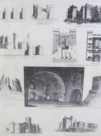
![1887 Engraving of Fortifications in Burgen [Germany], from Meyer's 'Konversations -...](https://d3525k1ryd2155.cloudfront.net/h/482/206/477206482.0.m.1.jpg)
1887 Engraving of Fortifications in Burgen [Germany], from Meyer's 'Konversations - Lexicon, 4. Aufl.' zum Artikel 'Burgen
by Meyers
- Used
- near fine
- Condition
- Used - Near Fine
- Quantity Available
- 1
- Seller
-
Webster, New York, United States
- Item Price
-
NZ$25.72NZ$10.61 shipping to USA
Show Details
Description:
Leipzig: Bibliographisches Institut, 1887. Print. Near Fine. Matted and ready for framing. Single vertical crease down middle, paper lightly toned. 1887 Print. Matted to 9 x 11 1/2 (mat measures 11 5/8 x 14 3/4). An engraved print showing eleven separate captioned images, illustrating several styles of fortification. Structures include: Burg Fleckenstein im Elsass (11. bis 16. Jahrh - Nach Specklin); Burg Steinsberg bei Heidelberg (auf romischer Anlage); Die Wartburg bei Eisenach (Ausgebildeter deutscher Burgstil des 12. Jahrh); Ursprunglicher Grundplan der Wartburg; Plan zur Herstellung der Burgruine Schadeck bei Neckarsteinach (12. Jahrh); Grundriss der Burg Schadeck; Burg zu Loches in Frankreich (Donjon, normannische Aulage); Barbacane u. Schloss zu Carcassone (Frankreich - Nach Viollet le Duc); Grundriss des Schlosses zu Carcassone; Burg zu Hedingham (Englisch-normannische Anlage); Grundriss der Burg zu Hedingham.
Item Price
NZ$25.72
NZ$10.61
shipping to USA
![1905 Charles Wilkinson Print: 'Windsor Castle from the Brocas' [County Berkshire], after...](https://d3525k1ryd2155.cloudfront.net/h/147/206/477206147.0.m.1.jpg)
1905 Charles Wilkinson Print: 'Windsor Castle from the Brocas' [County Berkshire], after a photograph by Poulton & Son, Lee
by [Wilkinson, Charles]
- Used
- very good
- Condition
- Used - Very Good
- Quantity Available
- 1
- Seller
-
Webster, New York, United States
- Item Price
-
NZ$25.72NZ$10.61 shipping to USA
Show Details
Description:
S.N, 1905. Print. Very Good. [Wilkinson, Charles]. Matted and reading for framing. Untrimmed. A few faint marginal smudges which could be easily removed by a professional paper conservator. 1905 Print. 10 x 7 1/2 sheet matted to 9 1/2 x 6 1/4 (mat measures 11 3/4 x 9). Color print from an original photograph of Windsor Castle, taken from a meadow on the opposite bank of the Thames called the brocas (named after a 13th century noble family). An artistic rendering that also provides a good level of architectural detail. The print depicts the complete northwest facade, the Round Tower and St George's Chapel figuring most prominently. Windsor Castle dates from the time of William the Conqueror, and remains an important symbol of the British nobility.
Item Price
NZ$25.72
NZ$10.61
shipping to USA
![1905 Charles Wilkinson Print: 'Nottingham Castle' [England], after a photograph by Hudson](https://d3525k1ryd2155.cloudfront.net/h/350/205/477205350.0.m.1.jpg)
1905 Charles Wilkinson Print: 'Nottingham Castle' [England], after a photograph by Hudson
by [Wilkinson, Charles]
- Used
- near fine
- Condition
- Used - Near Fine
- Quantity Available
- 1
- Seller
-
Webster, New York, United States
- Item Price
-
NZ$25.72NZ$10.61 shipping to USA
Show Details
Description:
S.N, 1905. Print. Near Fine. [Wilkinson, Charles]. Matted and reading for framing. Untrimmed. An exceptional example. 1905 Print. 10 x 7 1/2 sheet matted to 9 1/2 x 6 1/4 (mat measures 11 3/4 x 9). Color print from an original photograph of Nottingham Castle. An artistic rendering that also provides a good level of architectural detail. The print depicts the portion of the castle facing the River Trent. While this fortress dates back to the time of William the Conqueror, it went through numerous renovations, most notably reconstruction after being burned by rioters in 1831.
Item Price
NZ$25.72
NZ$10.61
shipping to USA
![1905 Charles Wilkinson Print: 'Walmer Castle' [Kent, England], after a photograph by...](https://d3525k1ryd2155.cloudfront.net/h/719/205/477205719.0.m.1.jpg)
1905 Charles Wilkinson Print: 'Walmer Castle' [Kent, England], after a photograph by Poulton & Son, Lee
by [Wilkinson, Charles]
- Used
- very good
- Condition
- Used - Very Good
- Quantity Available
- 1
- Seller
-
Webster, New York, United States
- Item Price
-
NZ$25.72NZ$10.61 shipping to USA
Show Details
Description:
S.N, 1905. Print. Very Good. [Wilkinson, Charles]. Matted and reading for framing. Untrimmed. Marginal smudges along top edge and bottom left corner which could be easily removed by a professional paper conservator. 1905 Print. 7 1/2 x 10 sheet matted to 6 1/4 x 9 1/2 (mat measures 9 x 11 3/4). Color print from an original photograph of Walmer Castle. An artistic rendering that also provides a good level of architectural detail. Appearing prominently in the foreground are a series of cannons beneath the eastern of four bastions surrounding the interior circular keep. The northern bastion forms the gatehouse, only the top portion of which is visible here. Two figures in the foreground are a useful addition to indicate scale. Walmer Castle was constructed in the mid-sixteenth century against the threat of Spanish and French invasion, but was not besieged until the English Civil War over one hundred years later.
Item Price
NZ$25.72
NZ$10.61
shipping to USA

Edgar Rice Burroughs Fanzine Ephemera Archive: ERB-dom, Twenty-Issue Continuous Run: Volume 1 No. 1 - Volume 1 No. 20 [with] The Forgotten Sea of Mars [with] Single Sheet of The Edgar Rice Burroughs Bazaar [with] Claude Held (Bookseller) Price List [with] Double-Sided Single Sheet Advertisement for Oparian #1 [with] Two Single-Fold Playbills for Productions of Tarzan and the Supermen [with] Jackets for Two Canaveral Press Editions (The Cave Girl and The Land That Time Forgot)
by Cazedessus, Camille 'Caz'; Guillory, Alfred; Resnick, Michael; [Burroughs, Edgar Rice]
- Used
- near fine
- first
- Condition
- Used - Near Fine
- Edition
- First Edition
- Quantity Available
- 1
- Seller
-
Webster, New York, United States
- Item Price
-
NZ$428.65NZ$10.61 shipping to USA
Show Details
Description:
Camille "Caz" Cazedessus, 1960. First Edition. Magazine. Near Fine. Macdonald, Neal. First editions with the exception of #s 1 & 2, which are second editions. 1960 Magazine. A collection of various materials related to Edgar Rice Burroughs, the author famous for his Tarzan and John Carter series. Includes: Edgar Rice Burroughs Fanzine Ephemera Archive: ERB-dom, Twenty-Issue Continuous Run: Volume 1 No. 1 - Volume 1 No. 20 [with] The Forgotten Sea of Mars [with] Single Sheet of The Edgar Rice Burroughs Bazaar [with] Claude Held (Bookseller) Price List [with] Double-Sided Single Sheet Advertisement for Oparian #1 [with] Two Single-Fold Playbills for Productions of Tarzan and the Supermen [with] Jackets for Two Canaveral Press Editions (The Cave Girl and The Land That Time Forgot). According to Heins in his A Golden Anniversary Bibliography of Edgar Rice Burroughs (1964): 'As new Burroughs material is published and as readers notify us of additions and corrections, Addenda to this…
Read More Item Price
NZ$428.65
NZ$10.61
shipping to USA

More Photos
Five 1868 Fortification Prints: Plates 1-5
by [No Author]
- Used
- near fine
- Condition
- Used - Near Fine
- Quantity Available
- 1
- Seller
-
Webster, New York, United States
- Item Price
-
NZ$128.60NZ$10.61 shipping to USA
Show Details
Description:
S.N, 1868. Print. Near Fine. Matted and reading for framing. Exceptional examples. 1868 Print. Five prints labeled plate 1-5, matted to about 9 3/4 x 6 1/4 each on a single mat measuring 23 1/4 x 30. Prints depict ancient fortresses, various well-labeled diagrams of star shaped fortifications, dissected views of coastal defensive batteries, and other details of siege and artillery warfare. Several are labeled 'Vol. 6' in the lower left-hand corner, indicating this was a series of prints appearing in the same book, likely an encyclopedia.
Item Price
NZ$128.60
NZ$10.61
shipping to USA
More Photos
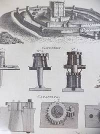
Four 1773 Georgian Prints: Fortification Plates CXXVII, CXCVII, CXCVIII, CXCIX
by Bell, A
- Used
- near fine
- Condition
- Used - Near Fine
- Quantity Available
- 1
- Seller
-
Webster, New York, United States
- Item Price
-
NZ$162.89NZ$10.61 shipping to USA
Show Details
Description:
A. Bell, 1773. Print. Near Fine. Matted and ready for framing. Untrimmed. Exceptional examples. 1773 Print. Four Georgian engravings, matted to 10 7 3/8 and presented on a single large mat (25 1/4 x 19 1/4). This group of prints illustrates well the use of star shaped fortifications, which became the standard in response to the extensive use of artillery beginning in the 15th century. Also pictured are diagrams of a catapult and a rather crude ballista, an example of a keep with several curtain walls, and a diagram of the foundation of a typical wall.
Item Price
NZ$162.89
NZ$10.61
shipping to USA

Didn’t find what you’re looking for?
Try adding this search to your want list. Millions of books are added to our site everyday and when we find one that matches your search, we’ll send you an email. Best of all, it’s free.
Add to Want List

Are you a frequent reader or book collector?
Join the Bibliophile's Club and save 10% on every purchase, every day — up to $20 savings per order!

Social Responsibility
Did you know that since 2004, Biblio has used its profits to build 16 public libraries in rural villages of South America?
