Description:
[Paris.]: From Petit Atlas Maritime, 1764. Original fold lines and a bit of waviness. Very good. A nicely detailed and well-executed map of Bermuda from the mid-part of the 18th century. The map appeared in Bellin's Petit Atlas Maritime in 1763 and 1764. This is state 2, with the addition of the plate number above the neat line at the upper left. The island's tribes are referred to here as cantons. Hamilton is indicated with a simple icon of twelve blocks. Seven forts are located. Reference: Palmer, Printed Maps of Bermuda (2nd edition): p. 9. mapforum.com, Checklist of Printed Maps of Bermuda, 1585-1778: 68.
Search Results: Authors starting with B from BICKERSTAFF'S BOOKS, MAPS &C.
You searched for:
- Bookseller inventory: BICKERSTAFF'S BOOKS, MAPS &C. (authors starting with B)
- Bookseller: BICKERSTAFF'S BOOKS, MAPS &C.
Results 1 - 2 of 2

Carte des Isles Bermudes ou de Sommer Tire de l'Anglois.
by [Map: Bermuda] Bellin.
- Used
- Very Good
- Condition
- Used - Very Good
- Quantity Available
- 1
- Seller
-
Scarborough, Maine, United States
- Item Price
-
NZ$1,239.38NZ$16.53 shipping to USA
Show Details
Item Price
NZ$1,239.38
NZ$16.53
shipping to USA
More Photos
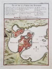
Plan de la ville de Boston.
by [Boston.] Bellin, Jacques Nicolas.
- Used
- Condition
- Used
- Quantity Available
- 1
- Seller
-
Scarborough, Maine, United States
- Item Price
-
NZ$743.62NZ$16.53 shipping to USA
Show Details
Description:
Classic Map of Boston from 1764A classic map of Boston and the immediately surrounding area published just after the French & Indian War. The map appeared in Bellin's Petit Atlas Maritime in 1764. A 16-item legend above the map identifies various public buildings, churches and fortifications.
Condition: Very good. Clear, dark impression with attractive hand color. Age toning at the edges. Wide margins. Crease in lower right margin outside of platemark.
[ICN 7512.3]
Item Price
NZ$743.62
NZ$16.53
shipping to USA

Didn’t find what you’re looking for?
Try adding this search to your want list. Millions of books are added to our site everyday and when we find one that matches your search, we’ll send you an email. Best of all, it’s free.
Add to Want List

Are you a frequent reader or book collector?
Join the Bibliophile's Club and save 10% on every purchase, every day — up to $20 savings per order!

Social Responsibility
Did you know that since 2004, Biblio has used its profits to build 16 public libraries in rural villages of South America?
