Description:
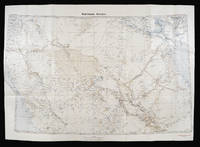
1807. 450 by 590mm. (17.75 by 23.25 inches).. Manuscript chart, with the tracks of HC Surrey, and HMS Jupiters convoy of 11 East Indiamen, naval ledger to verso, minor worming. The chart depicts the track of H.M.S. Jupiter passing Madagascar in the year 1807. As the chart states: 'The track of His Majesty's Ship Jupiter Commodore Baker in 1807 having under his Convoy eleven Indiamen who being prevented going to the north by constant Northerly Winds on getting the SE Trade carried the Fleet thro' this passage without meeting any Island or Shaol' As is stated above she was acting as escort for eleven East Indiamen. The continuing war with France had left many of the convoys to India, the East Indies, and China vulnerable to attack by French ships. As a reaction to this threat the British began to sail in convoy and, as here, with a military escort. H.M.S. Jupiter was a 50 gun fourth rate ship-of-the-line launched in 1778. She was wrecked on the 10th December 1808 - just three months after her…
Read More Search Results: Authors starting with C from Daniel Crouch Rare Books Ltd
You searched for:
- Bookseller inventory: Daniel Crouch Rare Books Ltd (authors starting with C)
- Bookseller: Daniel Crouch Rare Books Ltd
Results 1 - 20 of 48

To Captain H.E.R. Baker of H.M.S. Jupiter and Commodore of the E.I. Fleet. This Chart of a new Passage tho' which he conducted the Fleet in August 1807: Manuscript chart of the track of H.M.S. Jupiter for the year 1807 is a Proof of his Anxiety for its quick arrival in India and is a mark of his esteem of his most obedt. and faithful, humble Servt. J.A. Camberledge.
by CAMBERLEDGE, J.A.
- Used
- Hardcover
- Condition
- Used
- Binding
- Hardcover
- Quantity Available
- 1
- Seller
-
London, United Kingdom
- Item Price
-
NZ$2,569.56NZ$32.12 shipping to USA
Show Details
Item Price
NZ$2,569.56
NZ$32.12
shipping to USA

et insularum adiacentium ex intima antiquitate chorographica descriptio.
by CAMDEN, William
- Used
- first
- Condition
- Used
- Quantity Available
- 1
- Seller
-
London, United Kingdom
- Item Price
-
NZ$34,260.80NZ$32.12 shipping to USA
Show Details
Description:
London,: Published by [printed at Eliot's court press] impensis Georg. Bishop,, 1600.. Atlases,""Britannia, sive florentissimorum regnorum Angliae, Scotiae, Hiberniae, A fine example of Camden's Britannia in a contemporary binding Quarto (202 by 142mm), engraved frontispiece by W. Rogers, two folding engraved maps, several engraved illustrations in text, a few full or double page, a few central leaves lightly age browned, very occasional light marginal foxing, fine contemporary French red morocco binding, triple-fillet border, gilt-stamped armorial supralibros on covers, monogram and title gilt on spine compartments. Collation: pp. [16], 831, [27], 30, [2], [2] pls. A finely bound copy of the first survey of Great Britain county by county and the first study of Roman Britain as perceived in the landscape of sixteenth century Britain. The present copy is in the fifth edition, with dedication to Queen Elizabeth, and is the first to include maps. William Camden (1551-1623) was an English…
Read More Item Price
NZ$34,260.80
NZ$32.12
shipping to USA
Northern Arabia.: Captain William Shakespear's Last Journey Shakespear's Last Journey. Carruthers.
by CARRUTHERS, Alexander Douglas Mitchell
- Used
- Condition
- Used
- Quantity Available
- 1
- Seller
-
London, United Kingdom
- Item Price
-
NZ$4,282.60NZ$32.12 shipping to USA
Show Details
Description:
War Office for the Geographical Society,, 1922.. Chromolithograph map. Map of northern Arabia by the Royal Geographical Society in 1922 including Jordan, Kuwait and southern Iraq. As one of the first European surveys of the region, the map reflects the British government's early efforts to shore up alliances in the area around the time of World War I. The map is likely the work of Douglas Carruthers, a cartographer for the British War Office. Caruthers worked alongside Harry St. John Bridgen Philby, Gertrude Bell, T.E. Lawrence and Captain William Shakepsear, the latter of which is noted on the chart. The map detail features altitude contour lines, lakes, rivers, and seasonal stream courses (wadis) .The chart is presented in three colours showing waters in blue, desert areas in brown, and place names, roads and railways in black. The Jaffa-Jersualem railway fragment is included along with the Hejaz Railway, running through Amman in the north and travelling south to Medina. This railway was…
Read More Item Price
NZ$4,282.60
NZ$32.12
shipping to USA
![[World and four continents]](https://d3525k1ryd2155.cloudfront.net/h/760/909/1162909760.0.m.jpg)
More Photos
[World and four continents]: Cary's rare wall maps of the world and four continents Cary's New Map of the Eastern and Western Hemisphere, containing the whole of the New Discoveries, and every Improvement to the Present time 1827; A New Map of Africa Exhibiting Its natural and Politi
by CARY, John
- Used
- Condition
- Used
- Quantity Available
- 1
- Seller
-
London, United Kingdom
- Item Price
-
NZ$32,119.50NZ$32.12 shipping to USA
Show Details
Description:
London,: Published by J. Cary, No.86 St. James's Street,, Jan.y, 1st, 1827 & 1828.. (world) 890 by 1720mm. (35 by 67.75 inches). (continents only) 920 by 860mm (36.25 by 33.75). Set of five hand-coloured engraved maps, dissected and mounted on linen, each folding into original green paper slipcase, with publisher's labels, rubbed. Rare set of John Cary's four sheet world map together with his four sheet maps of the continents. John Cary (1754-1835) was a London based cartographer active in the early part of the 19th century. Ronald Vere Tooley, the prominent English map historian, writes of Cary, "As an engraver he was elegant and exact with fine clear lettering and great delicacy of touch." Cary began his work as an engraver, cartographer, and globe maker in 1776 with his New and Correct English Atlas. This important atlas represented a new phase in cartography where accuracy and detail rose in prominence over the decorative embellishments of the 18th century. This change was indicative of the…
Read More Item Price
NZ$32,119.50
NZ$32.12
shipping to USA

Carte de la Lune.: Cassini's seminal Lunar Map
by CASSINI, Jean-Dominique
- Used
- Condition
- Used
- Quantity Available
- 1
- Seller
-
London, United Kingdom
- Item Price
-
NZ$107,065.00NZ$32.12 shipping to USA
Show Details
Description:
Paris,: Jean-Dominique Cassini,, 1787.. 557 by 567mm. (22 by 22.25 inches).. Engraved map. The first state of Cassini IV's reissue of his great-grandfather's rare and "elegant" lunar map. Jean-Dominique Cassini, known as Cassini IV, (1748-1845) was born at the observatory in Paris which his great-grandfather, also called Jean-Dominique Cassini, (1625-1712) had founded. The elder Cassini was born in Liguria, and studied at the Panzano Observatory under Giovanni Battista Riccioli and Francesco Maria Grimaldi. In 1669, he moved to France on the invitation of Colbert to help set up and become the first director of the new Paris Observatory. Cassini ordered a 34-foot telescope from the great instrument maker Giuseppe Campani for the new observatory, which would prove to be crucial in the creation of his lunar map. Cassini made approximately sixty drawings of the moon between 1671 and 1679, with the assistance of the artists Sebastien Leclerc and Jean Patigny. The observations took place when possible…
Read More Item Price
NZ$107,065.00
NZ$32.12
shipping to USA

More Photos
Carte de France dite Carte de Cassini...: You have cost me more territory than all my enemies!"
by CASSINI de THURY, Cesar François
- Used
- Condition
- Used
- Quantity Available
- 1
- Seller
-
London, United Kingdom
- Item Price
-
NZ$85,652.00NZ$32.12 shipping to USA
Show Details
Description:
Paris,, [1678-1815].. 8vo (195 by 112mm). 184 mapsheets (each approximately 565 by 885mm), dissected and mounted on linen, 50mm tear to 3 maps, small (10 by 5mm) hole in sheet 99, 14 maps with some glue residue, 7 with very slight discolouration, one of the two key maps torn at folds, edged in blue silk, housed within 183 contemporary mottled sheepskin cases, gilt. Collation: 182 mapsheets which, if joined, would comprise an approximately 11 metre square map of France together with two key maps; 'Carte générale de la France par Départemens Servant à l'Assemblage des 182 feuilles...' and 'la Nouvelle carte qui comprend les principaux Triangles qui servent de Fondement à la Description géométrique de La France' (1744). 3 of the smaller maps have been trimmed and mounted to the neighbouring sheets. Namely: sheet 125 (Cherbourg) is attached to sheet 93 (La Houghue), sheet 160 (Noirmoutiers) is attached to sheet 131 (Nantes), and sheet 182 (Camarat) is on sheet 155 (Toulon). A complete set of…
Read More Item Price
NZ$85,652.00
NZ$32.12
shipping to USA

Carte de la Lune.: Cassini's seminal Lunar Map
by CASSINI, Jean-Dominique
- Used
- Condition
- Used
- Quantity Available
- 1
- Seller
-
London, United Kingdom
- Item Price
-
NZ$107,065.00NZ$32.12 shipping to USA
Show Details
Description:
Paris,: Jean-Dominique Cassini,, 1787.. 557 by 567mm. (22 by 22.25 inches).. Engraved map. The first state of Cassini IV's reissue of his great-grandfather's rare and "elegant" lunar map. Jean-Dominique Cassini, known as Cassini IV (1748-1845), was born at the observatory in Paris which his great-grandfather, also called Jean-Dominique Cassini (1625-1712), had founded. The elder Cassini was born in Liguria, and studied at the Panzano Observatory under Giovanni Battista Riccioli and Francesco Maria Grimaldi. In 1669, he moved to France on the invitation of Colbert to help set up and become the first director of the new Paris Observatory. Cassini ordered a 34-foot telescope from the great instrument maker Giuseppe Campani for the new observatory, which would prove to be crucial in the creation of his lunar map. Cassini made approximately 60 drawings of the moon between 1671 and 1679, with the assistance of the artists Sebastien Leclerc and Jean Patigny. The observations took place, when possible,…
Read More Item Price
NZ$107,065.00
NZ$32.12
shipping to USA
![[Russian Map of the Spread of Cholera].](https://d3525k1ryd2155.cloudfront.net/h/265/910/1162910265.0.m.jpg)
[Russian Map of the Spread of Cholera].: Rare epidemiological map depicting the spread of the 1892 Cholera Epidemic across Russia
by [CASTELLI, C. de]
- Used
- Condition
- Used
- Quantity Available
- 1
- Seller
-
London, United Kingdom
- Item Price
-
NZ$3,211.95NZ$32.12 shipping to USA
Show Details
Description:
[St. Petersburg, c1893].. 360 by 410mm (14.25 by 16.25 inches).. Lithograph map in two colours. This extremely rare map depicts the spread of the Russian Cholera Epidemic of 1892, which officially claimed 267,800 lives. The map is one of only a handful of Cholera maps to have been printed entirely in Russian Cyrillic, and was lithographed in St. Petersburg not long after the outbreak by C. de Castelli. The map embraces the western two-thirds of the Russian Empire, extending eastward just past Lake Baikal. The Russian Cholera Epidemic of 1892 was part of the Fifth International Cholera Pandemic (1881-96), and as shown here by a series of red arrows, the epidemic first entered Russian territory from Persia. From there it travelled across the Caspian Sea, through the Caucuses and then up north-westwards across the Steppes to infect Kiev, Moscow, St. Petersburg and Warsaw. Next, the epidemic wheeled eastwards, travelling across Siberia, almost as far as Irkutsk. Russia was especially vulnerable to…
Read More Item Price
NZ$3,211.95
NZ$32.12
shipping to USA

More Photos
Geology, Familiarly Illustrated by C. M. W.: Geology Personified
by W[EBBER] C[atherine]. M[ary].
- Used
- Condition
- Used
- Quantity Available
- 1
- Seller
-
London, United Kingdom
- Item Price
-
NZ$7,494.55NZ$32.12 shipping to USA
Show Details
Description:
London,: J. B. Goodinge, 21 Aldergate Street,, 1859.. Oblong octavo (130 by 150mm), continuous strip view, measuring 320 cm in length, containing thirty-one numbered and captioned hand-coloured lithographed scenes illustrating geology in a humorous vein, imprint label pasted to inside of back cover, original marbled covers with publisher's label pasted on. Humorous panorama illustrating geological features and stratification. Catherine Mary Webber (1831-1900), the wife of the Anglican clergyman Rev. William Fynes Webber, is known to have published three comical illustrated works such as this. The other two are 'The Experiences of an Amateur Artist' published in 1858 and 'Miss Scratchley, an Amateur in Art and Crinoline' in 1863. She also contributed to 'The English Woman's Journal' under the moniker 'A Clergyman's Wife.' The scenes herein are captioned: 1. "Gneiss on Granite". 2. "Cumbriam System". 3. "Cambriam System". 4. "Flags, and Transition Conglomerate". 5. "Silurian System". 6.…
Read More Item Price
NZ$7,494.55
NZ$32.12
shipping to USA
![[Portolan chart of the Mediterranean].](https://d3525k1ryd2155.cloudfront.net/h/972/506/1391506972.0.m.jpg)
[Portolan chart of the Mediterranean].: A fine portolan chart by Cavallini
by CAVALLINI, Gio[vanni] Batt[ista]
- Used
- Hardcover
- Signed
- Condition
- Used
- Binding
- Hardcover
- Quantity Available
- 1
- Seller
-
London, United Kingdom
- Item Price
-
NZ$85,652.00NZ$32.12 shipping to USA
Show Details
Description:
Livorno,, 1642.. 210 by 530 mm. (8.25 by 20.75 inches).. Manuscript portolan chart on vellum heightened in gold (sheet size 210 by 530 mm) with wooden roller attached on right edge and white thread attached onto the left. Manuscript portolan chart representing the Mediterranean sea and the main coastal locations. It includes the names of the three continents -Europe, Asia and Africa- in banderols as well as the names of the major regions -counter-clockwise: Marocho, Fessa, Orano, Algieri, Tremisen, Tunesi, Tripoli, Misurata, Libia, Barcha, Alesandria, Egitto, Iudea, Soria, Caramania, Natolia, Romania, Graecia, Albania, Bosena, Friuli, Toscana, Liguria, Provenza, Linguadoca, Catalognia, Valenzia, Mucia, Andaluzia, Portogallo. Portolan charts originated in Italy in the thirteenth century as an aid for navigators. They use rhumb lines radiating from compass roses and other points in order to lay routes from harbour to harbour. Generally drawn on vellum and often embellished in silver and gold, they…
Read More Item Price
NZ$85,652.00
NZ$32.12
shipping to USA

Make & Sell all Sorts of Jewellers work Funeral & Motto Rings, &c Likewise Sell all Sorts of Plate, Watches, Silver Plated, Steel & Metal Buckles, Combs, Cutlery, Hardware, Spectacles, Rules, Mathematical Instruments, &c. NB Buys Jewels, Old Gold & Silver Watches, Old Lace &c
by CHALMERS, George; and ROBINSON
- Used
- Condition
- Used
- Quantity Available
- 1
- Seller
-
London, United Kingdom
- Item Price
-
NZ$3,854.34NZ$32.12 shipping to USA
Show Details
Description:
London,: At the Golden Spectacles, in Sidneys Alley, Leicester Fields, , [from 1773]. 200 by 155mm. (7.75 by 6 inches).. Prints,""Chalmers & Robinson Jewellers & Goldsmith, - M is for Metal Worker Engraved trade card, loss to lower right and upper corners. Opulent trade card in the highest rococo style, the asymmetrical cartouche dripping with all examples of a wide range of Chalmers and Robins's wares: dividers, rulers, telescopes, cups, ink wells, jugs, jewels, coffee pots, spectacles, cutlery, cruets, fobs, buckles, rings, platter and pendants. There are three trade cards in Heal collection for Chalmers & Robinson, giving their addresses as at the Ring & Cup in Walkers Court, Berwick Street, Soho, from 1760; the Sidney Alley address, as here, from 1773, as it is a corner location, is the same building as No.1 Princes Street, which was used until 1783 by the company, and until 1793, by Chalmers alone. BM Heal 67.75
Item Price
NZ$3,854.34
NZ$32.12
shipping to USA

Cakes of all sorts Wholesale & Retail.
by CHAPMAN, [Edward]
- Used
- Condition
- Used
- Quantity Available
- 1
- Seller
-
London, United Kingdom
- Item Price
-
NZ$749.46NZ$32.12 shipping to USA
Show Details
Description:
[London],: Original Oakley Bun House Chelsea,, [c1824-1836].. 70 by 90mm. (2.75 by 3.5 inches).. Prints,""Chapman Fancy Bread and Biscuit Baker, Pastry Cook &c. B is for Bread and Biscuit Baker Engraved trade card. Trade card for another proprietor of the Old Chelsea Bun House, in this case Edward Chapman. Chapman is listed in various documents as proprietor of the Chelsea Bun House between 1824 and 1836; presumably he worked alongside or on behalf of the final member of the original Hand family. To judge by the list of baked goods provided on the present trade card, the Bun House offered far more than its signature delicacy. The card displays the bakery's distinctive shop-front, which Heal notes stood on what is now """"the site of No.52 Pimlico Road"""". BM Heal 6.8
Item Price
NZ$749.46
NZ$32.12
shipping to USA

More Photos
A Map of the County of Essex: Essex - The finest large-scale map of Essex From an Actual Survey made in MDCCLXXII, MDCCLXXIII and MDCCLXXIV by John Chapman and Peter Andre.
by CHAPMAN, John & ANDRE, Peter
- Used
- Hardcover
- Condition
- Used
- Binding
- Hardcover
- Quantity Available
- 1
- Seller
-
London, United Kingdom
- Item Price
-
NZ$9,635.85NZ$32.12 shipping to USA
Show Details
Description:
London,: Chalk Meggy and Chalk,, [1831].. Folio (440 by 390 mm), index map, and 25 double-page engraved map sheets, all with fine original hand-colour, some minor offsetting, modern half calf over marbled paper boards. Chapman and André's survey of Essex was one of the most celebrated of the nineteenth century large-scale maps with a wealth of detail matched by extraordinary accuracy, even when checked against large-scale contemporary estate maps. Minor roads were depicted on a map of the county for the first time with bridges, milestones and turnpike gates, whilst on the long coastline every creek, wharf, quay, ferry, duck decoy and cliff is shown. The countryside is extensively delineated with hills, woods, parks and heaths clearly depicted and often named. Except in the towns and villages, nearly every house and cottage is marked, whilst the principal seats and their owners, and most of the manor houses, and farm houses are named. There are complete sheets devoted to the vignette title (an Essex…
Read More Item Price
NZ$9,635.85
NZ$32.12
shipping to USA
Vue et Description de la Ville de Meaco Capitale du Japon: Views of Kyoto avec d'autres particularitez du pays.
by CHATELAIN, Henri Abraham
- Used
- Condition
- Used
- Quantity Available
- 1
- Seller
-
London, United Kingdom
- Item Price
-
NZ$749.46NZ$32.12 shipping to USA
Show Details
Description:
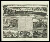
[Amsterdam,, 1714-1720].. 437 by 519mm. (17.25 by 20.5 inches).. Engraved sheet with five views and a plan. A folio sheet with five views and one plan of locations in Japan from Henri Abraham Chatelain's 'Atlas Historique'. The French text in the middle described the cities of Kyoto and Tokyo. The views are of Kyoto, the Dutch settlement of Deshima, two views of the town and temple Sakai, a Japanese marriage ceremony, and the persecution of Christian martyrs. Deshima was the base of the Dutch East India Company and one of the few areas in which European traders were allowed during the sakoku period. The 'Atlas Historique' was an ambitious work covering genealogy, cosmography, topography, heraldry and chronology.
Item Price
NZ$749.46
NZ$32.12
shipping to USA

avec les Royaumes qui luy sont Tributaires et les Isles de Sumatra Andemaon etc., et les isles voisines sure les observations des Jusuites Envojez par le Roy Louis XIV en Qualite de Ses Mathematiciens dans les Indes et a la Chine, ou l'on voit aus si La Route qu'ils ont tenue par le Destroit de la Sonde Jusqu'a Siam
by CHATELAIN, Jean Baptiste Claude
- Used
- Condition
- Used
- Quantity Available
- 1
- Seller
-
London, United Kingdom
- Item Price
-
NZ$1,177.72NZ$32.12 shipping to USA
Show Details
Description:
[Amsterdam,: François L'Honoré & Compagnie Libraries,, 1719].. 480 by 545mm. (19 by 21.5 inches).. Maps,""Le Royaume de Siam """"Cincapura au Cingapura"""" Engraved chart. Singapore, as """"Cincapura au Cingapura"""", appears at the center of this detailed map of Southeast Asia. Showing present-day Thailand, the Malay Peninsula, the Malacca and Singapore Straits, and the islands of Borneo, Sumatra and Java, with shipping routes from Batavia to Thailand marked. Published in the fifth volume of the Châtelain family's 'Atlas historique, ou Nouvelle introduction à l'Histoire, à la Chronologie & à la Géographie Ancienne et Moderne
', 1719, which eventually extended to 7 volumes. The Chatelains based their maps on the work of contemporary and earlier cartographers and travel writers, and the current map is based on the Jaillot - Mortier map derived from accounts of the French Jesuit mission to Siam in 1685-86.
Item Price
NZ$1,177.72
NZ$32.12
shipping to USA
Vue et Description de la Ville de Meaco Capitale du Japon: View of Kyoto avec d'autres particularitez du pays.
by CHATELAIN, Henri Abraham
- Used
- Condition
- Used
- Quantity Available
- 1
- Seller
-
London, United Kingdom
- Item Price
-
NZ$749.46NZ$32.12 shipping to USA
Show Details
Description:
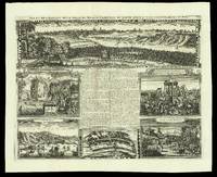
[Amsterdam,, 1714-1720].. 450 by 549mm. (17.75 by 21.5 inches).. Engraved sheet with five views and a plan. A folio sheet with five views and one plan of locations in Japan from Henri Abraham Chatelain's 'Atlas Historique'. The French text in the middle described the cities of Kyoto and Tokyo. The views are of Kyoto, the Dutch settlement of Deshima, two views of the town and temple Sakai, a Japanese marriage ceremony, and the persecution of Christian martyrs. Deshima was the base of the Dutch East India Company and one of the few areas in which European traders were allowed during the sakoku period. The 'Atlas Historique' was an ambitious work covering genealogy, cosmography, topography, heraldry and chronology.
Item Price
NZ$749.46
NZ$32.12
shipping to USA

avec les Royaumes qui luy sont Tributaires et les Isles de Sumatra Andemaon etc., et les isles voisines sure les observations des Jusuites Envojez par le Roy Louis XIV en Qualite de Ses Mathematiciens dans les Indes et a la Chine, ou l'on voit aus si La Route qu'ils ont tenue par le Destroit de la Sonde Jusqu'a Siam
by CHATELAIN, Jean Baptiste Claude
- Used
- Condition
- Used
- Quantity Available
- 1
- Seller
-
London, United Kingdom
- Item Price
-
NZ$1,177.72NZ$32.12 shipping to USA
Show Details
Description:
[Amsterdam,: François L'Honoré & Compagnie Libraries,, 1719].. 450 by 510mm. (17.75 by 20 inches).. Maps,""Le Royaume de Siam """"Cincapura au Cingapura"""" Engraved chart. Singapore, as """"Cincapura au Cingapura"""", appears at the center of this detailed map of Southeast Asia. Showing present-day Thailand, the Malay Peninsula, the Malacca and Singapore Straits, and the islands of Borneo, Sumatra and Java, with shipping routes from Batavia to Thailand marked. Published in the fifth volume of the Châtelain family's 'Atlas historique, ou Nouvelle introduction à l'Histoire, à la Chronologie & à la Géographie Ancienne et Moderne
', 1719, which eventually extended to 7 volumes. The Chatelains based their maps on the work of contemporary and earlier cartographers and travel writers, and the current map is based on the Jaillot - Mortier map derived from accounts of the French Jesuit mission to Siam in 1685-86. Huguenot pastor Henri Abraham Chatelain (16841743) was born in Paris, but moved…
Read More Item Price
NZ$1,177.72
NZ$32.12
shipping to USA
Succession des Empereurs du Japon: The Emperors' lineage avec une description du Meutre de L'Empereur Cubo et la Reception des Ambassadeurs Hollandois en ce Pays la
by CHATELAIN, Zacharie and CHATELAIN, Henri Abraham
- Used
- Condition
- Used
- Quantity Available
- 1
- Seller
-
London, United Kingdom
- Item Price
-
NZ$642.39NZ$32.12 shipping to USA
Show Details
Description:
[Amsterdam,: François L'Honoré & Compagnie Libraries,, 1719].. 483 by 565mm. (19 by 22.25 inches).. Double-page engraved map. With an inset of Japan, 'Carte du Japon'. Published in the fifth volume of the Chatelain family's 'Atlas historique, ou Nouvelle introduction à l'Histoire, à la Chronologie & à la Géographie Ancienne et Moderne
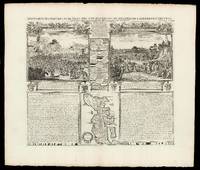
', 1719, when eventually extended to 7 volumes. The vignette map is a more traditional representation of Japan than the other that appears in the 'Atlas'. It was probably borrowed from Pieter van der Aa, who in turn, drew on Sanson's model of 1652. It appears between two large text panels, one concerning the death of the Emperor of Japan, the other with the Dutch 'Embassy' there in 1644. Zacharie Chatelain (d. 1723) was the father of Henri Abraham (1684-1743) and Zacharie Junior (1690-1754). They worked as a partnership publishing the 'Atlas
' under several different Chatelain imprints, depending on the Chatelain family partnerships at the time of publication.…
Read More Item Price
NZ$642.39
NZ$32.12
shipping to USA
Succession des Empereurs du Japon: The Emperors' lineage avec une description du Meutre de L'Empereur Cubo et la Reception des Ambassadeurs Hollandois en ce Pays la
by CHATELAIN, Zacharie and CHATELAIN, Henri Abraham
- Used
- Condition
- Used
- Quantity Available
- 1
- Seller
-
London, United Kingdom
- Item Price
-
NZ$642.39NZ$32.12 shipping to USA
Show Details
Description:
[Amsterdam,: François L'Honoré & Compagnie Libraries,, 1719].. 441 by 515mm. (17.25 by 20.25 inches).. Engraved spread with family tree, two scenes, text and inset map. With an inset of Japan, 'Carte du Japon'. Published in the fifth volume of the Chatelain family's 'Atlas historique, ou Nouvelle introduction à l'Histoire, à la Chronologie & à la Géographie Ancienne et Moderne
', 1719, when eventually extended to 7 volumes. The vignette map is a more traditional representation of Japan than the other that appears in the 'Atlas'. It was probably borrowed from Pieter van der Aa, who in turn, drew on Sanson's model of 1652. It appears between two large text panels, one concerning the death of the Emperor of Japan, the other with the Dutch 'Embassy' there in 1644. Zacharie Chatelain (d. 1723) was the father of Henri Abraham (1684-1743) and Zacharie Junior (1690-1754). They worked as a partnership publishing the 'Atlas
' under several different Chatelain imprints, depending on the Chatelain…
Read More Item Price
NZ$642.39
NZ$32.12
shipping to USA
![[Manuscript plan of Nagasaki].](https://d3525k1ryd2155.cloudfront.net/h/251/506/1391506251.0.m.jpg)
[Manuscript plan of Nagasaki].: The port and city of Nagasaki
by CHOKANEMON
- Used
- Hardcover
- Signed
- Condition
- Used
- Binding
- Hardcover
- Quantity Available
- 1
- Seller
-
London, United Kingdom
- Item Price
-
NZ$130,619.30NZ$32.12 shipping to USA
Show Details
Description:
Nagasaki,, [c1740].. 700 by 1250mm. (27.5 by 49.25 inches).. Coloured manuscript map, preserved in folding case covered in blue cloth. A detailed manuscript plan of Nagasaki that predates the earliest printed map of Nagasaki made in 1745 (McGovern, Imago Mundi Vol.15, 1960), and the first dated map of Nagasaki which was published in 1752. It shows navigation into Nagasaki, the town, its layout and surrounding areas, orientated to the North West, names in Japanese Katakana and classical Chinese, signed in lower right corner "Chokanemon". The city, streets, temples, shrines, waterways, ships and boats, gardens and fortifications are clearly depicted. Most of these features are labelled on the map. The small fan-shaped island in the bay is Dejima, an artificial island built in 1634 to house Portuguese traders who were expelled in 1639. It was subsequently taken by the Dutch V.O.C. trading out of Batavia in 1641. During most of the Edo period Dejima was the single place of direct trade and exchange…
Read More Item Price
NZ$130,619.30
NZ$32.12
shipping to USA

Didn’t find what you’re looking for?
Try adding this search to your want list. Millions of books are added to our site everyday and when we find one that matches your search, we’ll send you an email. Best of all, it’s free.
Add to Want List

Are you a frequent reader or book collector?
Join the Bibliophile's Club and save 10% on every purchase, every day — up to $20 savings per order!

Social Responsibility
Did you know that since 2004, Biblio has used its profits to build 16 public libraries in rural villages of South America?
