Description:
Madrid,: Direccion de Hidrografia,, 1816 [c.1866].. 650 by 900mm (25.5 by 35.5 inches).. Engraved chart, with the Direccion de Hidrografia blindstamp. A detailed chart of the Caribbean coast of Venezuela, showing Caracas, Curaçao and Aruba. The lighthouses are marked with colour.
Search Results: Authors starting with M from Daniel Crouch Rare Books Ltd
You searched for:
- Bookseller inventory: Daniel Crouch Rare Books Ltd (authors starting with M)
- Bookseller: Daniel Crouch Rare Books Ltd
Results 1 - 20 of 43

2.a Hoja que comprehende la parte de Costa de Tierra Firme e Islas adyacentes...: Venezuela, showing Caracas & Curaçao
by DIRECCION HIDROGRAFICA DE MADRID
- Used
- Condition
- Used
- Quantity Available
- 1
- Seller
-
London, United Kingdom
- Item Price
-
NZ$5,309.00NZ$31.85 shipping to USA
Show Details
Item Price
NZ$5,309.00
NZ$31.85
shipping to USA

e Topografiche.
by MAGGI, Giovanni Battista
- Used
- Condition
- Used
- Quantity Available
- 1
- Seller
-
London, United Kingdom
- Item Price
-
NZ$2,548.32NZ$31.85 shipping to USA
Show Details
Description:
Turin and Florence,, [c1862].. 214 by 156mm. (8.5 by 6.25 inches).. Books,""Catalogo di alcune fra le migliori e piu' recenti carte geografiche Book supplier to the King of Italy Octavo pamphlet, 21pp., index, 1 blank. Unrecorded edition of one of the very rare stock lists of Giovanni Battista Maggi, an Italian publisher and trader of maps, who later became a famous photographer. He was the official supplier of books and maps to his majesty Victor Emanuel II of Italy, as indicated on the title-page: """"provveditore di stampe di s[ua] m[aesta]"""". The catalogue contains a large number of maps of countries from all over the world, with a large selection of maps of Italy, but also notable selections of Germany, Asia, America and France. Apparently only a few of the maps were published by Maggi himself. One of the maps of Italy by Sagansan bears the date 1862, so the present inventory was probably issued around the same time, as is confirmed by several other maps, such as Andriveau Goujon's 'Carte…
Read More Item Price
NZ$2,548.32
NZ$31.85
shipping to USA

More Photos
King Street Guildhall; The Mansion House; New Palace Yard; The Royal Exchange.: My real Master"
by MALTON, Thomas
- Used
- Condition
- Used
- Quantity Available
- 1
- Seller
-
London, United Kingdom
- Item Price
-
NZ$8,494.40NZ$31.85 shipping to USA
Show Details
Description:
London,: T. Malton, No.8 Carlisle Street, Soho,, 1781-1783.. each approximately 370 by 505mm (14.5 by 20 inches). Sheet: each approximately 495 by 555mm (19.5 by 21.75 inches).. Four engravings with aquatint, printed in sepia. Four views of London by Thomas Malton the Younger (1748-1804), an early pioneer of the aquatint technique. He taught J.M.W. Turner, who called him "my real master". A member of the Royal Academy, Malton is best known for his work 'A Picturesque Tour through the Cities of London and Westminster', with one hundred aquatint views. These four examples come from a set of twelve prints that were not part of 'A Picturesque Tour' (BL). The prints show Guildhall, the centre of civic government in London, where the Lord Mayor and Sheriffs met; Mansion House, the official residence of the Lord Mayor of London, designed by the architect George Dance and finished only in 1752 after 13 years of building works; New Palace Yard; and the Royal Exchange in its second incarnation. The original…
Read More Item Price
NZ$8,494.40
NZ$31.85
shipping to USA
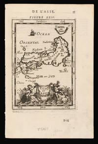
Isles dv Iapon.: From Manesson-Mallet's description of the world
by MANESSON-MALLET, Alain
- Used
- Condition
- Used
- Quantity Available
- 1
- Seller
-
London, United Kingdom
- Item Price
-
NZ$265.45NZ$31.85 shipping to USA
Show Details
Description:
[Paris,: Chez Denys Thierry,, 1683].. 210 by 139mm. (8.25 by 5.5 inches).. Engraved map, French text on verso. From the second volume of Manesson-Mallet's five volume description of the world 'Description de L'Univers', published first in 1683 in French, and then again in French and German in 1684 and 1685, followed by a final German edition of 1719. Manesson-Mallet (1630-1706) was an engineer in the service of the King of Portugal. On his return to France, he was appointed Master of mathematics to the pages of King Louis XIV. In addition to his history of the world, he also wrote a book about fortifications 'Les Travaux de Mars', and another about surveying and mapmaking 'La Geometrie Pratique, divisee en quatre livers' Hubbard 50.
Item Price
NZ$265.45
NZ$31.85
shipping to USA

The Sea of Marmara: The Sea of Marmara with Istanbul and the Bosphorus from surveys by Captn Manganari Russian Navy 1845, 48 and Captain Spratt and other Officers of the R.N.
by MANGANARI, Captain and SPRATT, Captain Thomas Abel Brimage
- Used
- Condition
- Used
- Quantity Available
- 1
- Seller
-
London, United Kingdom
- Item Price
-
NZ$3,185.40NZ$31.85 shipping to USA
Show Details
Description:
London,: The Admiralty,, 1859. Corrections to 1873. Minor corrections to 1877.. 650 by 1005mm (25.5 by 39.5 inches).. Engraved chart, 14 inset views, a few tears to lower margin and image skilfully repaired, some loss to imprint, reapired, old gule marks to verso. This rare chart of the Sea of Marmara was made at a critical time in the region's history. The Sea of Marmara, the Black Sea, and the Bosporus and Dardanelles straits are of central importance for the governance of Istanbul, and so the conflicts of the Ottoman Empire often rested on a detailed understanding of the waters. In the 1840s, joint Ottoman and Russian forces launched an expedition under Captain Manganari to complete the first systematical survey of the Black Sea using triangulation, which "deserves to be counted among the greatest contributions to the cartography of the sea" (King); the results of their work were published as an atlas, which "deserves to be counted among the greatest contributions to the cartography of the sea"…
Read More Item Price
NZ$3,185.40
NZ$31.85
shipping to USA

and Royal Family,... Court & Installation Plumes Mounted as usual. Curious Feathers & Artificial Flowers of every description. Feathers cleaned dyed & dressed with care and punctuality. Manufacturer of Gold & Silver Court Trimmings.
by MANNING, [R]
- Used
- Condition
- Used
- Quantity Available
- 1
- Seller
-
London, United Kingdom
- Item Price
-
NZ$424.72NZ$31.85 shipping to USA
Show Details
Description:
[London],: 152 Regent Street,, [c1837-1849].. 75 by 115mm (3 by 4.5 inches).. Prints,""Manning, Late Carbery. Plumassier to her Majesty Queen Dowager P is for Plumassier Engraved trade card. The demand for elaborate feathers to adorn hats, dresses and other accessories begot a huge surge in the plumasserie industry during the eighteenth and nineteenth centuries. This in turn led to intensive hunting of certain birds, even causing the decline or disappearance of some species; indeed, such was the impact on the avian world that associations such as the Royal Society for the Protection of Birds were established to oppose it. At the end of the nineteenth century, there were nearly eight hundred houses in Paris employing six to seven thousand plumassiers, often dealing with only one type of feather at a time. During the same period, London's plumasserie industry was largely concentrated in the East End. It was certainly a lucrative business, with £500,000 worth of ostrich feathers were imported into…
Read More Item Price
NZ$424.72
NZ$31.85
shipping to USA

More Photos
Carte Geologique des Etas-Unis et des Provinces Anglaises de l'Amerique du Nord: Presentation copy of Jules Marcou's geological map of the United States to Auguste Trecul avec un Profil Geologique allant de la valleee du Mississipi aux cotes du Pacifique, et une plance de fossils. Extrait du Bulletin de la societe Geologique de France
by MARCOU, Jules
- Used
- Hardcover
- Condition
- Used
- Binding
- Hardcover
- Quantity Available
- 1
- Seller
-
London, United Kingdom
- Item Price
-
NZ$8,494.40NZ$31.85 shipping to USA
Show Details
Description:
Paris,: Imprimerie de L. Martinet,, 1855.. 230 by 150mm. (9 by 6 inches).. 8vo., 124 pages, large folding chromolithographed map, folding lithographed plate of fossils, original plain grey paper wrappers, title inscribed by Marcou on the front cover. The first geological map of the United States to stretch beyond the Mississippi, over the Rocky Mountains and all the way to the west coast of America. First published in 1853, the current map is updated to include the complete west coast up to the 50th parallel, and adds a 'Profil geologique du Fort Smith (Arkansas) au Pueblo de los Angeles (Californie)' surveyed by Lt. Amiel Weeks Whipple, as part of his survey of the Thirty-fifth parallel for the Pacific Railroad, which extended from Fort Smith, Arkansas, to Pueblo de los Angeles. Jules Marcou (1824-1898) was a French geologist, who spent the majority of his working life in the United States. Marcou first travelled to the States, in 1847, under the direction of the Jardin des Plantes, in order to…
Read More Item Price
NZ$8,494.40
NZ$31.85
shipping to USA

A View of the Solar System and Orbit of the Comet, (with its proper Elevation,) which will next return;: The transit of Halley's comet in 1758 truely representing all its Appearances for any Part of the Year.
by MARTIN, Benjamin
- Used
- Condition
- Used
- Quantity Available
- 1
- Seller
-
London, United Kingdom
- Item Price
-
NZ$25,483.20NZ$31.85 shipping to USA
Show Details
Description:
London,: Published according to Act of Parliament,, Feb. 24th 1757.. 255 by 372mm. (10 by 14.75 inches).. Engraved broadside, three dimensional flap illustrating the perihelion, complete comet cut-outs, text on either sides. The instrument shows the probable transit of Halley's comet in 1758. The plane of the comet, with the various comet tails, can be tilted at an angle above the ecliptic plane in order to simulate the inclination of the cometary orbit. At the end of the accompanying text, Martin warns: "At its descending Node, it will be very near the Earths Orbit; and should that happen the 12th of May we should be in a dangerous Situation, as the denser Part of its blazing Tail would then envelope the Earth, which God forbid." Edmond Halley, in his 1705 'Synopsis of the Astronomy of Comets', used Newton's Laws to calculate the effects of the gravitational pull of Jupiter and Saturn of cometary bodies. He calculated that the comet of 1682 was the same as those observed by Petrus Apianus in 1531…
Read More Item Price
NZ$25,483.20
NZ$31.85
shipping to USA

Impero del Giappone: From Benedetto Marzolla's "Atlante geografico" Questa Carta e stata eseguita su quella pubblicata in Londra nel 1835, dalla Societa per la diffusione delle utili conoscenze, e su quella di Arrowsmith; e fa parte del l'Atlante Geografico che si pubblica da
by MARZOLLA, Benedetto after the Society for the Diffusion of Useful Knowledge and ARROWSMITH, Aaron
- Used
- Condition
- Used
- Quantity Available
- 1
- Seller
-
London, United Kingdom
- Item Price
-
NZ$286.69NZ$31.85 shipping to USA
Show Details
Description:
Naples,: Benedetto Marzolla., 1847.. 693 by 525mm. (27.25 by 20.75 inches).. Lithographed map with notes and statistical tables. A map of Japan from Benedetto Marzolla's unusual and scarce atlas, the "Atlante geografico". The note in the title cartouche acknowledges the debt of the mapmaker to both Aaron Arrowsmith and the Society for the Diffusion of Useful Knowledge. Benedetto Marzolla (1801-1858) was an Italian soldier and cartographer. He was a lieutenant engineer in the Neapolitan army and ran his own lithography business. Each of the maps in his atlas, as here, is accompanied by extensive notes on the country shown and acknowledgements of the cartographers whose work he had used.
Item Price
NZ$286.69
NZ$31.85
shipping to USA

Impero del Giappone: A map of Japan from Benedetto Marzolla's 'Atlante geografico' Questa Carta e stata eseguita su quella pubblicata in Londra nel 1835, dalla Societa per la diffusione delle utili conoscenze, e su quella di Arrowsmith; e fa parte del l'Atlante Geografico che
by MARZOLLA, Benedetto after the Society for the Diffusion of Useful Knowledge and ARROWSMITH, Aaron
- Used
- Condition
- Used
- Quantity Available
- 1
- Seller
-
London, United Kingdom
- Item Price
-
NZ$318.54NZ$31.85 shipping to USA
Show Details
Description:
Naples,: Benedetto Marzolla., 1847.. 673 by 516mm. (26.5 by 20.25 inches).. Lithographed map with notes and statistical tables, dissected and laid on linen, original hand colour. A map of Japan from Benedetto Marzolla's unusual and scarce atlas, the "Atlante geografico". The note in the title cartouche acknowledges the debt of the mapmaker to both Aaron Arrowsmith and the Society for the Diffusion of Useful Knowledge. Benedetto Marzolla (1801-1858) was an Italian soldier and cartographer. He was a lieutenant engineer in the Neapolitan army and ran his own lithography business. Each of the maps in his atlas, as here, is accompanied by extensive notes on the country shown and acknowledgements of the cartographers whose work he had used.
Item Price
NZ$318.54
NZ$31.85
shipping to USA

London and Westminster, 1669.: London
by MAWMAN, J.
- Used
- Condition
- Used
- Quantity Available
- 1
- Seller
-
London, United Kingdom
- Item Price
-
NZ$637.08NZ$31.85 shipping to USA
Show Details
Description:
London,: Published by J. Mawman,, 1821.. Aquatint. Title and imprint in margin b.c. View of the metropolis from Lambeth looking across the Thames to Westminster Abbey, and showing the built-up area from Millbank to the Tower. The remains of old St Paul's with its Inigo Jones facade is to be seen, and numerous church towers that survived the Great Fire of 1666. The engraving appears between pp.162-163 in Travels of Como the Third, Grand Duke of Tuscany through England... 1669 (London: Joseph Mawman 1821). An unknown artist made copies of the drawings of Como III's journal, housed in the Laurentian Library, Florence. Shepherd was commissioned to reduce and redraw the images for aquatinting. The drawing for this print is in the British Museum's Crace Collection.
Item Price
NZ$637.08
NZ$31.85
shipping to USA

Bootlegger's Map of the United States. Honi soit qui mal y pints!: The wet, the dry and the hypocrites!
by [MCCANDLISH, Edward]
- Used
- Condition
- Used
- Quantity Available
- 1
- Seller
-
London, United Kingdom
- Item Price
-
NZ$3,185.40NZ$31.85 shipping to USA
Show Details
Description:
[Detroit, Michigan],: Griswold Press,, [c1926].. 550 by 870mm (21.75 by 34.25 inches).. Lithograph map on two map sheets joined. McClandish's satirical map of America became one of the best known and most widely circulated maps of the prohibition era. It depicts the United States as an alcohol-sodden explosion of illicit activity, with smugglers covertly carrying barrels of beer over the Canadian border, and supply boats off the East coast providing necessary relief for victims of the era's liquor ban. Originally published in full colour for the Washington Post in 1926, the image soon grew so popular that it was separately issued as a broadsheet poster by Griswold Press in Detroit, of which the present map is an example. In addition, Hagstrom Company continued to produce a fully coloured linen-backed version, designed to ornament the rooms of "games rooms, fraternity houses, dormitory rooms, or private bars" (Hornsby), which remained in print for the following two decades. The map was also syndicated…
Read More Item Price
NZ$3,185.40
NZ$31.85
shipping to USA

Chart of West Coast of North America from Mt. St. Elias to Columbia River.: A unique, accomplished, and mammoth manuscript of the American West Coast
by McCLINTOCK, John Tilton
- Used
- Condition
- Used
- Quantity Available
- 1
- Seller
-
London, United Kingdom
- Item Price
-
NZ$33,977.60NZ$31.85 shipping to USA
Show Details
Description:
[Concord, NH or Dorchester, MA?] , 1889.. (approx.) 915 by 4080mm. (36 by 160.75 inches).. Ink and watercolor wash on laid paper, backed with canvas and mounted on rollers, with bright colors and surface almost entirely intact but for a bit of creasing and some minor chipping along rollers. This manuscript by New Hampshire native John Tilton McClintock depicts the northwest coast from the Alaska panhandle to Tillamook County, Oregon. The son of an expert surveyor and himself a future architect, McClintockin his late teens at the timewas already an accomplished draftsman. His map shows the complex coastal outline and the region's many islands, employs shading to indicate in a general way the many mountains and mountain ranges, names major geographical features and towns, and outlines county boundaries in Oregon and Washington. This data is superimposed on a carefully-drawn coordinate grid. The intent of the map appears to have been to illustrate or memorialize a round-trip journey from Puget…
Read More Item Price
NZ$33,977.60
NZ$31.85
shipping to USA

Hudson Market: Done by Order of the Corporation by John W. Comb Esq., City Surveyor, New York, 22nd December, 1784. Examined & Approved by the Common Council,... & ordered to be filed in the Clerk’s Office. Rob.t Benson Esq.
by McCOMB, John; and Robert BENSON Esq.,
- Used
- Condition
- Used
- Quantity Available
- 1
- Seller
-
London, United Kingdom
- Item Price
-
NZ$42,472.00NZ$31.85 shipping to USA
Show Details
Description:
Original pen and ink and colour wash on vellum, contemporarymanuscript title on verso "Hudson Market", later inscription "Vesey Street Market", "3-S", old vertical folds. 285 by 315mm (11.25 by 12.5 inches).Original manuscript plat map of the area in lower Manhattan that would later become the site of the World Trade Center, and ultimately the 9/11 Memorial
The new Hudson Market, historically known as the Bear Market, is depicted in this map oriented with southeast to the top, bordered by Greenwich Street to the left, Vesey Street and "Corporation Dock" at the bottom, Partition Street along the top, and a "Dock" and a "Slip" extending into the Hudson River on the right. The survey is amongst the earliest work of the young City Surveyor, John McComb, and was prepared to record the auction of nine new lots, here coloured green, on land recently reclaimed from the Hudson River.
What is now site of the 9/11 Memorial, first appeared in a survey of 1625, as one small corner of thirty-three acres set aside… Read More
Item Price
NZ$42,472.00
NZ$31.85
shipping to USA
Showing the Route of Mess.rs Burke and Wills, from Melbourne to the Gulf of Carpentaria [and] Map of Mr. McKinlay's Route, in search of Mess.rs Burke and Wills, in Sept.r and Oct.r, 1861 (Reduced from the Original).
by MCKINLAY, John; BURKE, Robert O'Hara; and William John WILLS
- Used
- Hardcover
- Condition
- Used
- Binding
- Hardcover
- Quantity Available
- 1
- Seller
-
London, United Kingdom
- Item Price
-
NZ$6,370.80NZ$31.85 shipping to USA
Show Details
Description:
London,: Ordered by the House of Commons, to be printed,... Henry Hansard, printer., 28 March, 1862.. 335 by 210mm. (13.25 by 8.25 inches).. Maps,""Map of the Eastern Part of Australia. """"the glorious race across the continent"""" (Sir Henry Barkly) One large folding and one full-page lithographed map, with contemporary hand-colour in outline (502 by 320; 280 by 170mm); bound into """"Hansard"""" paper 'Australian Exploring Expedition. (Burke and Wills)... Copy of all Despatches from Sir Henry Barkly and the other Colonial Governors on the subject of the Australian Exploring Expedition', folio; stabbed and sewn as issued, preserved in archival buckram-backed portfolio. The censorious official report, issued as part of the royal commission, into the disappearance of legendary Australian explorers Burke and Wills: a tragic tale of hubris and mischance of epic proportions emblazoned into the heart of every Australian. The signal intent of the expedition, commissioned by the state of Victoria's…
Read More Item Price
NZ$6,370.80
NZ$31.85
shipping to USA

London: Two figures with London in the back ground
by [MEIJER, A.]
- Used
- Condition
- Used
- Quantity Available
- 1
- Seller
-
London, United Kingdom
- Item Price
-
NZ$318.54NZ$31.85 shipping to USA
Show Details
Description:
[Pieter van der Aa?],, [early 17th century].. 365 by 395mm. (14.25 by 15.5 inches).. Engraved print. An early seventeenth century print of London, with two inhabitants in the foreground. London Bridge and old St Paul's Cathedral are visible in the background. The woman in the foreground is bare breasted, a style supposedly adopted by aristocratic Englishwomen, although this may have been an artistic interpretation of the fashion for extremely décolleté bodices. The equally elegantly dressed man carries a swagger stick and wears his hair short with two long 'love locks' on his shoulders. The print appears in Allard's 'Orbis "Orbis habitabilis" is a rare and interesting book illustrating towns and costumes. In many cases a plate of a town is followed by another showing the costume of the inhabitants , as is shown in this view of Paris. The images are excellent in design and execution, and wide-ranging and comprehensive in subject matter. Carel Allard is considered to be the first compiler of a…
Read More Item Price
NZ$318.54
NZ$31.85
shipping to USA

More Photos
Pomponij Mellæ Cosmographi Geographi: 'If, in a new lease of life, a man seeks to attain the worm-like paths of geography, he is bound to find the flowers that belong there, for he deserves them' Prisciani quo ex dionysio Thessalonicensi de situ orbis interpretation. Pomponij Mellae de orbis
by MELA, Pomponius.
- Used
- Hardcover
- first
- Condition
- Used
- Binding
- Hardcover
- Quantity Available
- 1
- Seller
-
London, United Kingdom
- Item Price
-
NZ$53,090.00NZ$31.85 shipping to USA
Show Details
Description:
Venice:: Erhard Ratdolt,, 18th July, 1482.. 190 by 143mm. (7.5 by 5.75 inches).. Two parts in one volume. Small 4to., full-page woodcut map of the world on a Ptolemaic cone-shaped projection surrounded by an architectural border, first page of text with headline printed in red, two 11-line and five five-line floriated initials, early marginal annotations to the first part throughout, mostly noting place-names in the text, nineteenth-century calf backed marbled paper boards, vellum corners, black morocco lettering-pieces on the spine. Collation: A-F(8) "The second woodcut map printed in Italy" (Campbell p.119). This was the first map to depict current Portuguese knowledge of the west coast of Africa which led, only six years later, to the rounding of the Cape of Good Hope. Campbell suggests that the edition's printer, Erhard Ratdolt, may have been the mapmaker, since this and his T-O map of 1480 are the two earliest woodcut maps printed in Italy. The title of the map "Novelle etati ad geographie…
Read More Item Price
NZ$53,090.00
NZ$31.85
shipping to USA

Map of Pennsylvania, Constructed from the County Surveys Corrected and Improved to 1825: Unrecorded example of Melish's map of Pennsylvania
by MELISH, John
- Used
- Condition
- Used
- Quantity Available
- 1
- Seller
-
London, United Kingdom
- Item Price
-
NZ$55,213.60NZ$31.85 shipping to USA
Show Details
Description:
Philadelphia,: Benjamin Tanner,, 1825.. 920 by 1450mm. (36.25 by 57 inches).. State 3. Large folding engraved map on six sheets,dissected in 40 sections and laid down on linen, with contemporary hand-colour in outline, trimmed with pale blue silk; folding into marbled paper ends and loosely inserted in contemporary red roan backed marbled paper chemise, gilt. Unrecorded example of state 3: with an additional imprint, not present on the 1822 editions of the map, found below the bottom border on the right: "Published by B. Tanner, Engraver. No. 74 South Eighth Street, Philadelphia", without manuscript ink annotations in the upper left corner of the map as on the State 1a 1822 editions. John Melish's map of Pennsylvania is one of the earliest important large format maps of an individual American state. The state of Pennsylvania authorized it with an 1816 legislative act, and John Melish created it using county maps from a variety of surveys conducted between 1816 and 1820. He delivered it in March…
Read More Item Price
NZ$55,213.60
NZ$31.85
shipping to USA

More Photos
Atlas.: The first 'atlas'
by MERCATOR, Gerard; Jodocus HONDIUS
- Used
- Hardcover
- Condition
- Used
- Binding
- Hardcover
- Quantity Available
- 1
- Seller
-
London, United Kingdom
- Item Price
-
NZ$212,360.00NZ$31.85 shipping to USA
Show Details
Description:
Amsterodami,: Judoci Hondij,, 1613.. Folio (480 by 330 mm), engraved title heightened in gold, (3) pp, engraved portrait of Mercator and Hondius, (9) pp., 374 pp., 45 double-page engraved maps, engraved half title (Galliae) heightened in gold, 30 double-page and one single-page engraved maps, engraved half title (Germaniae) heightened in gold, 29 double-page engraved maps, engraved half title (Italiae, Slavoniae et Graeciae) heightened in gold, 45 double-page engraved maps, 18 ff, full original hand colour throughout, 150 maps in total, contemporary mottled calf, spine divided into seven sections with raised bands, gilt, restoration to capitals and lower back. A fine example of a great atlas. Gerard Mercator (1512-1594) would not begin his great 'Atlas' or 'Cosmography' until relatively late in life. The impetus for this came when he was employed as cosmographer to Duke William IV of Kleve, in 1563. Mercator's intention was to produce a work that consisted of five books and covered the whole…
Read More Item Price
NZ$212,360.00
NZ$31.85
shipping to USA

Europa, ad magnae Europae Gerardi Mercatoris: Mercator's map of Europe with the imaginary island of Frisland P. imitationem, Rumoldi Mercatoris F. cura edita, servato tamen initio longitudinis ex ratione magnetis, quod Pater in magna sua universali posuit
by MERCATOR, Rumold; Gerald MERCATOR
- Used
- Condition
- Used
- Quantity Available
- 1
- Seller
-
London, United Kingdom
- Item Price
-
NZ$3,079.22NZ$31.85 shipping to USA
Show Details
Description:
[Duisberg,, 1595].. 388 by 515mm. (15.25 by 20.25 inches).. Double page engraved map with contemporary colour. With no text on back. Top edge trimmed to image, bottom edge trimmed to neat line. This very fine map of Europe is from Mercator's 'Atlas sive Cosmographicae Meditationes de Fabrica Mundi et Fabricati Figura,' first published in 1595. This rare early edition with the ornate strapwork cartouche was only used until 1606 when the cartouche was changed. The geography on the map relates to Mercator's wall map of the world in 1569. There are a number of fictitious elements to the map that originated with the Venetian Nicolo Zeno from 1558. According to Zeno's map, his noble ancestors Nicolò and Antonio had discovered America in the 15th centur,y prior to Columbus, but ended up stranded on an island called Frisland (Frislant), south of Iceland, which does not exist. Mercator included Zeno's information on his maps and due to his esteemed reputation, the inaccuracies continued to appear on…
Read More Item Price
NZ$3,079.22
NZ$31.85
shipping to USA

Didn’t find what you’re looking for?
Try adding this search to your want list. Millions of books are added to our site everyday and when we find one that matches your search, we’ll send you an email. Best of all, it’s free.
Add to Want List

Are you a frequent reader or book collector?
Join the Bibliophile's Club and save 10% on every purchase, every day — up to $20 savings per order!

Social Responsibility
Did you know that since 2004, Biblio has used its profits to build 16 public libraries in rural villages of South America?
