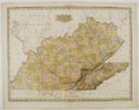
Description:
Philadelphia: H. S. Tanner, 1825. Copper-engraving with full period color. Tanner's 1825 map of Kentucky and Tennessee. Henry Tanner's A New American Atlas was the most distinguished atlas published in America during the nineteenth century. The maps were carefully constructed from the best and most recent surveys. They were finely engraved on a large-scale, printed on high quality paper, and carefully hand colored. Because of the great expense involved in the production and publication, the atlas was published in five parts between 1819 and 1823. This map was first published in 1823 in the fifth part of Henry Tanner's A New American Atlas under the title "Kentucky, Tennessee and part of Illinois." In this second issue, from the 1825 edition of the atlas, Illinois has been dropped from the title and the map has been augmented by the addition of new counties (particularly in southwestern Tennessee) and the additions of various cities and roads. Phillips Atlases 3669-13; cf. Ristow, American Maps and…
Read More Search Results: Authors starting with T from Donald Heald Rare Books
You searched for:
- Bookseller inventory: Donald Heald Rare Books (authors starting with T)
- Bookseller: Donald Heald Rare Books
Results 1 - 20 of 102
More Photos
Kentucky and Tennessee ... Improved to 1825
by TANNER, Henry Schenck (1786-1858)
- Used
- Condition
- Used
- Quantity Available
- 1
- Seller
-
New York, New York, United States
- Item Price
-
NZ$7,704.00FREE shipping to USA
Show Details
Item Price
NZ$7,704.00
FREE shipping to USA

More Photos
A New American Atlas containing Maps of the Several States of the North American Union, projected and drawn on a uniform scale from documents found in public offices of the United States and State Governments, and other original and authentic information by Henry S. Tanner
by TANNER, H.[enry] S.[chenck] (1786-1858)
- Used
- Condition
- Used
- Quantity Available
- 1
- Seller
-
New York, New York, United States
- Item Price
-
NZ$102,720.00FREE shipping to USA
Show Details
Description:
Philadelphia: H.S. Tanner, 1823. Folio. (24 x 16 3/4 inches). Letterpress half-title, 1p. index and 18pp. text. Engraved title with vignette of the "First Landing of Columbus in the New World", 18 fine hand-coloured engraved maps (16 double-page, 2 folding). Expertly bound to style in half-calf over contemporary marbled paper-covered boards, the flat spine gilt and divided into seven compartments by fillets and roll tools, lettered in the second compartment, the others with repeat decoration in gilt, marbled endpapers A fine copy of the first collected edition of "the most distinguished atlas published in the United States during the engraving period" (Ristow). Tanner's New American Atlas contained the most accomplished series of maps of America that had yet appeared in an atlas. Of the greatest importance were the maps of American states. These maps were drawn up using a careful combination of original surveys and the best existing published sources. The evident high cost of production meant that…
Read More Item Price
NZ$102,720.00
FREE shipping to USA

More Photos
New York
by TANNER, H.[enry] S.[chenck] (1786-1858)
- Used
- Condition
- Used
- Quantity Available
- 1
- Seller
-
New York, New York, United States
- Item Price
-
NZ$3,424.00FREE shipping to USA
Show Details
Description:
Philadelphia: H. S. Tanner, 1825. Engraved with full, period colour. Mild off-set throughout. Repaired 6" split at bottom of center fold. A fine example of Tanner's updated map of New York. Henry Tanner's A New American Atlas, was the most distinguished atlas published in America during the nineteenth century. The maps were carefully constructed from the best and most recent surveys. They were finely engraved on a large-scale, printed on high quality paper, and carefully hand coloured. Because of the great expense involved in the production and publication, the atlas was published in five parts between 1819 and 1823. It was an ambitious project but one clearly called for as the country rapidly expanded. Western New York was among the first "western" regions of the United States on which people speculated. It was generally supposed to be better for agriculture than in fact it was; many farms were abandoned by their owners. One of the major factors in the future prosperity of the state was the Erie…
Read More Item Price
NZ$3,424.00
FREE shipping to USA

More Photos
Tarif General des Droits des Sorties et Entrées du Royaume, & des Provinces Esquelles les Bureaux ne sont establis, ordonnés estre levés sur toutes les marchandises & denrées...avec l'edit du roy...
by [FRENCH TARIFFS]
- Used
- Condition
- Used
- Quantity Available
- 1
- Seller
-
New York, New York, United States
- Item Price
-
NZ$2,140.00FREE shipping to USA
Show Details
Description:
Paris, 1664. Quarto. [2],96 [i.e., 91],21pp. Minor soiling, Very good. Disbound An extensive list of tariffed items, divided into two sections, with "Sorties" (exports) and "Entrees" (imports). Imports listed include many different kinds of wood, including numerous colonial products, some American, such as ebony and cedar; sugar; cotton; indigo; and various kinds of skins, including beaver pelts. The second part of this work is a royal edict concerning the lowering of tariffs on goods and foods. Each work with an individual titlepage as well as the collective titlepage at the beginning. Not in Kress or Goldsmith.
Item Price
NZ$2,140.00
FREE shipping to USA

More Photos
A History of the Campaigns of 1780 and 1781, in the Southern Provinces of North America
by TARLETON, Sir Banastre (1754-1833)
- Used
- Condition
- Used
- Quantity Available
- 1
- Seller
-
New York, New York, United States
- Item Price
-
NZ$10,272.00FREE shipping to USA
Show Details
Description:
London: printed for T. Cadell, 1787. Quarto. (10 13/16 x 8 1/2 inches). vii, [1], 518pp. plus one leaf of publisher's ads. Folding engraved map with routes marked by hand in color, and four folding engraved plans, with positions and troop movements marked by hand in colors. Early 20th-century half brown morocco, patterned endpapers, spine elaborately gilt in six compartments with raised bands. First edition of a key work concerning the southern campaigns of the American Revolution. Tarleton, the commander of a Tory cavalry unit, the British Legion, served in America from May 1776 through the siege of Yorktown. He was infamous for his brutal tactics and hard-riding attacks. His narrative is one of the principal British accounts of the Revolution, notable for his use of original documents, a number of which are included as notes following the relevant chapters. The handsome maps and plans include "The Marches of Lord Cornwallis in the Southern Provinces...," showing the Carolinas, Maryland, Virginia…
Read More Item Price
NZ$10,272.00
FREE shipping to USA

Statement Explanatory of the Public Interest in William Tatham's Topographical and Other Employments, in Aid of the Department of War...
by TATHAM, William (1752-1819)
- Used
- Condition
- Used
- Quantity Available
- 1
- Seller
-
New York, New York, United States
- Item Price
-
NZ$1,284.00FREE shipping to USA
Show Details
Description:
Washington, D.C., 1813. 8pp. Some foxing and dampstaining. Disbound. The beginning of the topographical engineers. A rare pamphlet in support of Tatham's goal of "the establishment of a topographical depot on public account." Among other proposals, Tatham suggests that the federal government might, through "liberal compensation," acquire his private library of topographic surveys and military plans as the basis for a national repository. Tatham was a persistent pursuer of Federal appointments. After serving in the Continental Army during the Revolution, he was active as a surveyor. When Jefferson, who he had evidently known for some time, became Secretary of State, Tatham badgered him for jobs, and secured a position laying out post roads. Later, when Jefferson was President, he became a commissioner of surveys of the Carolina coast. Tatham sought similar employment under Madison. Between 1790 and 1809 he must have amassed a body of material, including plans for defending the Chesapeake during a…
Read More Item Price
NZ$1,284.00
FREE shipping to USA

More Photos
Carte de l'Amerique corrigee et augmentee dessus Toutes les aultres cy devant faictes par P. Bertius
by TAVERNIER, Melchior (1564-1641)
- Used
- Condition
- Used
- Quantity Available
- 1
- Seller
-
New York, New York, United States
- Item Price
-
NZ$4,280.00FREE shipping to USA
Show Details
Description:
[Paris, 1627. Copper-engraved map, insets of polar regions. Scarce first state of Tavernier's separately-issued map of North America, including insets of the Arctic and Antarctic regions. In 1627, Tavernier, the most important mapseller and publisher in France, published a set of the four continents after Bertius, though possibly without his permission. Although crediting Bertius, the map more closely follows the Hondius mapping of 1618, with the completed northwest coast line, similar mapping of the Great Lakes and similar decorative ships and sea monsters (though without the decorative surround). However, unlike the Hondius map, here the southern coast of Tierra del Fuego is completed, as per the Bertius map of 1624. The map was first issued separately, and then issued in Tavernier's Theatre Geographique. The present example is the rare, separately-issued first state; the subsequent issue published after 1640 included additional toponyms, such as "Neuf Amsterdam" (i.e. New York), "Pleymouth",…
Read More Item Price
NZ$4,280.00
FREE shipping to USA

More Photos
The Cabinet of Genius, being a Series of Engravings, comprising a copious variety of interesting subjects, selected from the most admired poetry, history &c. Engraved by the Best Artists ..
by TAYLOR, Charles (1756-1823)
- Used
- Condition
- Used
- Quantity Available
- 1
- Seller
-
New York, New York, United States
- Item Price
-
NZ$1,112.80FREE shipping to USA
Show Details
Description:
London: C. Taylor, 1789. Quarto. (9 x 7 1/2 inches). 37 (of 40) original parts (lacking part numbers 22, 27 and 35). 2 engraved titles and 74 (of 95) stipple engraved plates printed in sepia engraved by Taylor and John Ogborne after Samuel Shelley and Robert Smirke. (Old dampstaining). Publisher's letterpress blue paper wrappers, part 8 lacking the front wrapper, part 31 lacking the rear wrapper Provenance: Reverend Mr. Wren (signature on part XXV) Taylor and Ogborne both studied under Bartolozzi, and their engravings here are superb. The authors represented include Shakespeare, Milton, Pope, Gay, Burns, Goldsmith and more. Sets of this work are rarely found complete, and sets in the original parts are almost unknown.
Item Price
NZ$1,112.80
FREE shipping to USA
More Photos
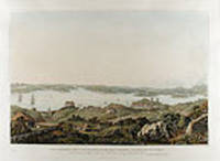
Part of the Harbour of Port Jackson, and the Country between Sydney and the Blue Mountains, New South Wales
by TAYLOR, James (Major, of his Majesty's 48th Regiment of Foot)
- Used
- Condition
- Used
- Quantity Available
- 1
- Seller
-
New York, New York, United States
- Item Price
-
NZ$2,140.00FREE shipping to USA
Show Details
Description:
London: Alecto Editions and the State Library of New South Wales, 1988. Originally engraved by Robert Havell and son, printed by Edward Egerton-Williams in colours and finished by hand, with printer's blindstamp. "By 1820, Sydney was a town of 12,000 inhabitants, about a third of whom were convicts. It had grown dramatically during the administration of Lachlan Macquarie who was appointed governor of New South Wales in 1810. Unlike previous governors, Macquarie was not content merely to oversee a penal colony. His vigorous building programme changed forever the appearance of Sydney, while his policy of accepting emancipated convicts as respected citizens demonstrated a social attitude strangely out of step with the times. Both these policies earned him criticism. In 1819, alarmed by Macquarie's extravagant public works, the British Government commissioned a lawyer and civil servant, J.T.Bigge, to investigate. The attacks by his critics were met head on by Macquarrie's supporters in New South Wales.…
Read More Item Price
NZ$2,140.00
FREE shipping to USA

More Photos
Three panoramic views of Port Jackson, in New South Wales, with the town of Sydney, and the adjacent scenery. After original drawings by ... Taylor... drawn from nature... between 1817 and 1822
by TAYLOR, James (Major, of his Majesty's 48th Regiment of Foot)
- Used
- Condition
- Used
- Quantity Available
- 1
- Seller
-
New York, New York, United States
- Item Price
-
NZ$5,136.00FREE shipping to USA
Show Details
Description:
Three plates, engraved by Robert Havell and son, printed by Edward Egerton-Williams in colours and finished by hand, each with printer's blindstamp. From an edition limited to 110 copies, printed from the original printing plates in 1988 employing the same techniques as used in 1823. This fine edition was published as a collaborative effort between the State Library of New South Wales and the renowned fine art publishers, Alecto Editions. "By 1820, Sydney was a town of 12,000 inhabitants, about a third of whom were convicts. It had grown dramatically during the administration of Lachlan Macquarie who was appointed governor of New South Wales in 1810. Unlike previous governors, Macquarie was not content merely to oversee a penal colony. His vigorous building programme changed forever the appearance of Sydney, while his policy of accepting emancipated convicts as respected citizens demonstrated a social attitude strangely out of step with the times. Both these policies earned him criticism. In 1819,…
Read More Item Price
NZ$5,136.00
FREE shipping to USA

More Photos
Mitla. A Narrative of Incidents and Personal Adventures on a Journey in Mexico, Guatemala, and Salvador in the years 1853 to 1855
by TEMPSKY, G.F. von
- Used
- Condition
- Used
- Quantity Available
- 1
- Seller
-
New York, New York, United States
- Item Price
-
NZ$1,027.20FREE shipping to USA
Show Details
Description:
London: Longman, Brown, Green, Longmans, & Roberts, 1858. (8 3/8 x 5 inchex). xv, [1], 436pp. Fourteen plates (five of them colored lithographs, one folding) and folding map. Contemporary blue polished calf, spine gilt extra, leather label. Provenance: Inscribed on the fly leaf: "C.S. Newton from his affectionate friend Alfred Trower. On his leaving Eton, Midsummer 1865." A wonderful account of travel in Mexico and Central America, illustrated with colour plates. Von Tempsky spent three years in the mining districts of California before setting out on his extensive travels through Mexico, Guatemala, and Salvador in 1853. His narrative includes five handsome color plates of Mexican town scenes, a view of Durango, the ruins at Mitla, and a "fight between the Ranchero and his Indian Antagonists." Edited by J.S. Bell. The map shows Mexico and most of Central America. Abbey, Travel 665; Palau 329979.
Item Price
NZ$1,027.20
FREE shipping to USA

Teniers's Kitchen. In the Common Parlour at Houghton
by TENIERS, After David II (1610-1690)
- Used
- Condition
- Used
- Quantity Available
- 1
- Seller
-
New York, New York, United States
- Item Price
-
NZ$1,626.40FREE shipping to USA
Show Details
Description:
London: John Boydell, 1777. Engraving, coloured by hand, by J.B. Michel. (Expert repair to upper margin just touching image area). A lively scene from the Flemish master of the interior genre picture. Born in Antwerp, David Teniers was the son of David Teniers I. He became a master of the Antwerp Guild of St Luke in 1632-3 after an apprenticeship to his father, with whom he also collaborated. In 1637 he married Anna, the daughter and heiress of Jan Breughel I. From the outset Teniers the younger was an extremely productive painter, thanks to his good relationship with Antwerp art dealers. During the 1630s he produced small-format religious scenes on commission for Chrysostoom van Immerseel, who supplied the Spanish market. However, it was Teniers's genre pieces that were greatly prized by the Antwerp dealers and made him famous. Teniers quickly became one of Antwerp's pace-setting and most successful painters, which probably accounts for his assumption of functions that carried a degree of social…
Read More Item Price
NZ$1,626.40
FREE shipping to USA

Riflessioni Geografische Circa Le Terre Incognite Disteie in ossequio perpetuo della nobilta veneziana
by TERRA ROSSA, Padre D. Vitale
- Used
- Condition
- Used
- Quantity Available
- 1
- Seller
-
New York, New York, United States
- Item Price
-
NZ$16,264.00FREE shipping to USA
Show Details
Description:
Padoua: Cadorino, 1686. Quarto. [32], 298, [10, Index]pp. including a portrait of the author. Half title. Contemporary vellum, manuscript spine title First issue of Terra Rossa's famous account detailing discoveries in the New World, as denoted by the 1686 date and the privilege below the imprint reading "Et Privilegio del Serenissimo Principe." Includes much information on Venetian explorers, going so far as to credit Marco Polo with discovering Australia, and attempts to rename Terra Australis as Terra Australe Magallanica to honor Magellan. In this work, Terra Rossa "attempted to prove that Venetians had discovered all lands unknown to the ancients, including America and Terra Australis..." (Hiatt, p. 261). He also defends the claims of the Zeno brothers to have made a northern discovery of America prior to Columbus. A rare and surprisingly little-known work focused on early exploration of the Southern Hemisphere. Sabin 94858; European Americana 686/157.
Item Price
NZ$16,264.00
FREE shipping to USA

More Photos
Acts, Joint Resolutions and Memorials Passed by the First Legislative Assembly of the Territory of Minnesota...[issued with:] Republication of Important General Laws of Wisconsin, now in Force in the Territory of Minnesota, by Provision of the Organic Act
by [MINNESOTA TERRITORIAL LAWS]
- Used
- Condition
- Used
- Quantity Available
- 1
- Seller
-
New York, New York, United States
- Item Price
-
NZ$4,280.00FREE shipping to USA
Show Details
Description:
Saint Paul: James M. Goodhue and Nathaniel M'Lean, 1850. xxxvii, 107, [1], [2], [1], [106]-213pp. Contemporary calf, gilt leather label. Small ink library stamps to first page of Constitution and each titlepage, faint marginal dampstain to last third of text Among the earliest Minnesota imprints. This is the record of the first session of the Territory of Minnesota legislature, and among the earliest of Minnesota imprints. Printing began in Minnesota in the summer of 1849, and this volume, covering the acts of the first legislature, was issued early in 1850. The printers Goodhue and M'Lean were not in partnership, but each printed a part of the work, hence the idiosyncrasies of layout and pagination. The preliminaries are composed of the Constitution and An Ordinance for the Government of the Territory of the United States Northwest of the River Ohio. A rare title, with only ten copies in OCLC. American Imprints Inventory (Minnesota) 17.
Item Price
NZ$4,280.00
FREE shipping to USA
![[Consecutive Run of Early Washington Territorial Laws, 1855 - 1869]](https://d3525k1ryd2155.cloudfront.net/h/717/265/859265717.1.m.jpg)
More Photos
[Consecutive Run of Early Washington Territorial Laws, 1855 - 1869]
by [WASHINGTON TERRITORIAL LAWS]
- Used
- Condition
- Used
- Quantity Available
- 1
- Seller
-
New York, New York, United States
- Item Price
-
NZ$6,848.00FREE shipping to USA
Show Details
Description:
Olympia, 1869. Fourteen volumes, individual publication details in the listing below. 20th-century tan buckram, gilt leather labels (one volume in black buckram). Minor chipping to labels, some staining. Small ink library stamps and ink ownership inscriptions on titlepages, most titlepages with embossed library blindstamp, some foxing and staining. A major run of Washington territorial laws, covering the years 1855-69, all printed in Olympia, the eventual state capital. The laws in this collection cover the period from the third to the sixteenth sessions of the territorial assembly. They begin over thirty years before Washington attained statehood on November 11,1889, and provide a fascinating look into the particular challenges of creating laws for a territory on the western extreme of the nation. All of these imprints are rare, with only one current retail offering of one of the imprints, and sparse auction records for any of them. The imprints included here are as follows: 1) Acts of the…
Read More Item Price
NZ$6,848.00
FREE shipping to USA

Galveston Entrance Front
by [Texas]
- Used
- Condition
- Used
- Quantity Available
- 1
- Seller
-
New York, New York, United States
- Item Price
-
NZ$2,140.00FREE shipping to USA
Show Details
Description:
Washington D.C.: Published by the United States Coast and Geodetic Survey, 1921. Nautical chart printed on heavy paper stock. Colored. A rare original coastal survey of Galveston area coastline encompassing the city of Galveston, Galveston Bay, Pelican Island, and the Bolivar Peninsula home to Crystal Beach. Established by President Thomas Jefferson in 1807 as the Survey of the Coast, the U.S. Coast and Geodetic Survey was the United States' first civilian scientific agency. This agency has followed its mission to survey the U.S. coastline, create nautical charts of the coast, and help increase maritime safety since its founding, and has often played fascinating roles in significant chapters of U.S. history. It served in all theaters of the Civil War in the service of the Union Army and Navy, pioneered acoustic exploration in the wake of the sinking of the Titanic, and during WWI it worked to detect enemy submarines. In addition, this agency worked to survey and produce detailed maps and renderings…
Read More Item Price
NZ$2,140.00
FREE shipping to USA

Sabine and Neches Rivers
by [Texas]
- Used
- Condition
- Used
- Quantity Available
- 1
- Seller
-
New York, New York, United States
- Item Price
-
NZ$1,712.00FREE shipping to USA
Show Details
Description:
Washington D.C.: Published by the United States Coast and Geodetic Survey, 1922. Large folding nautical chart, printed on heavy paper stock. Colored. A rare original coastal survey of Texas-Louisiana border area in Southwest Texas along the Sabine and Neches Rivers encompassing the majority of the Golden Triangle Area including Beaumont, Orange, and Sabine Lake. Established by President Thomas Jefferson in 1807 as the Survey of the Coast, the U.S. Coast and Geodetic Survey was the United States' first civilian scientific agency. This agency has followed its mission to survey the U.S. coastline, create nautical charts of the coast, and help increase maritime safety since its founding, and has often played fascinating roles in significant chapters of U.S. history. It served in all theaters of the Civil War in the service of the Union Army and Navy, pioneered acoustic exploration in the wake of the sinking of the Titanic, and during WWI it worked to detect enemy submarines. In addition, this agency…
Read More Item Price
NZ$1,712.00
FREE shipping to USA

San Luis Pass to Matagorda Bay
by [Texas]
- Used
- Condition
- Used
- Quantity Available
- 1
- Seller
-
New York, New York, United States
- Item Price
-
NZ$1,712.00FREE shipping to USA
Show Details
Description:
Washington D.C.: Published by the United States Coast and Geodetic Survey, 1922. Large folding nautical chart, printed on heavy paper stock. Colored. A rare original coastal survey of the area coastline around Houston encompassing Galveston, Freeport, Surfside Beach, the San Bernard National Wildlife Refuge, Matagorda, and the Brazos River, . Established by President Thomas Jefferson in 1807 as the Survey of the Coast, the U.S. Coast and Geodetic Survey was the United States' first civilian scientific agency. This agency has followed its mission to survey the U.S. coastline, create nautical charts of the coast, and help increase maritime safety since its founding, and has often played fascinating roles in significant chapters of U.S. history. It served in all theaters of the Civil War in the service of the Union Army and Navy, pioneered acoustic exploration in the wake of the sinking of the Titanic, and during WWI it worked to detect enemy submarines. In addition, this agency worked to survey and…
Read More Item Price
NZ$1,712.00
FREE shipping to USA

Mississippi River to Galveston
by [Texas, Louisiana, & Mexico]
- Used
- Condition
- Used
- Quantity Available
- 1
- Seller
-
New York, New York, United States
- Item Price
-
NZ$1,626.40FREE shipping to USA
Show Details
Description:
Washington D.C.: Published by the United States Coast and Geodetic Survey, 1920. Large folding nautical chart, printed on heavy paper stock. Colored. A rare original coastal survey of Gulf Coast of Texas and Louisiana including Galveston, Beaumont, Sabine Lake, Marsh Island, Barrier Islands, New Orleans, Lake Pontchartrain, and the Mississippi River. Established by President Thomas Jefferson in 1807 as the Survey of the Coast, the U.S. Coast and Geodetic Survey was the United States' first civilian scientific agency. This agency has followed its mission to survey the U.S. coastline, create nautical charts of the coast, and help increase maritime safety since its founding, and has often played fascinating roles in significant chapters of U.S. history. It served in all theaters of the Civil War in the service of the Union Army and Navy, pioneered acoustic exploration in the wake of the sinking of the Titanic, and during WWI it worked to detect enemy submarines. In addition, this agency worked to…
Read More Item Price
NZ$1,626.40
FREE shipping to USA

Gulf Coast of the United States: Mississippi River to the Rio Grande
by [Texas, Louisiana, & Mexico]
- Used
- Condition
- Used
- Quantity Available
- 1
- Seller
-
New York, New York, United States
- Item Price
-
NZ$2,140.00FREE shipping to USA
Show Details
Description:
Washington D.C.: Published by the United States Coast and Geodetic Survey, 1919. Large folding nautical chart, printed on heavy paper stock. Colored. A rare original coastal survey of Gulf Coast from the Rio Grande to the Mississippi River and includes Mexico, Corpus Christi, Galveston, and New Orleans. Established by President Thomas Jefferson in 1807 as the Survey of the Coast, the U.S. Coast and Geodetic Survey was the United States' first civilian scientific agency. This agency has followed its mission to survey the U.S. coastline, create nautical charts of the coast, and help increase maritime safety since its founding, and has often played fascinating roles in significant chapters of U.S. history. It served in all theaters of the Civil War in the service of the Union Army and Navy, pioneered acoustic exploration in the wake of the sinking of the Titanic, and during WWI it worked to detect enemy submarines. In addition, this agency worked to survey and produce detailed maps and renderings of…
Read More Item Price
NZ$2,140.00
FREE shipping to USA

Didn’t find what you’re looking for?
Try adding this search to your want list. Millions of books are added to our site everyday and when we find one that matches your search, we’ll send you an email. Best of all, it’s free.
Add to Want List

Are you a frequent reader or book collector?
Join the Bibliophile's Club and save 10% on every purchase, every day — up to $20 savings per order!

Social Responsibility
Did you know that since 2004, Biblio has used its profits to build 16 public libraries in rural villages of South America?
