Description:
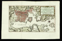
[Leiden,, 1724].. Large folio. (55 x 33 cm). Composite atlas comprising 23 engraved mapsheets incorporating two large multi-sheet wall-maps and 6 double-page maps (4 with fine original hand-colour with a separate letterpress title and key pasted to bottom), title leaves of the large map somewhat browned, upper joint weak, blind tooled vellum with rules and ornamental centre piece with arabesques, gilt, small split at headband, spine in 10 compartments with raised bands, gilt. A fine composite atlas of maps and views of the city of Leiden, with Hagen's famous wall-maps, both large and small and both complete. It incorporates Leiden's administrative structure in beautiful, strong contemporary hand-colour. The large wall-map, issued in 1670, is engraved on 10 double-page and 4 full-page mapsheets, while the small wall-map, issued five years later, is printed on 3 double-page mapsheets. Both maps include lovely engraved views of the city, especially the 9 larger views of the 1670 map. Very…
Read More Search Results: Authors starting with V from Daniel Crouch Rare Books Ltd
You searched for:
- Bookseller inventory: Daniel Crouch Rare Books Ltd (authors starting with V)
- Bookseller: Daniel Crouch Rare Books Ltd
Results 1 - 17 of 17
![[Composite atlas of Leiden].](https://d3525k1ryd2155.cloudfront.net/h/166/910/1162910166.0.m.jpg)
More Photos
[Composite atlas of Leiden].: A fine composite atlas of Leiden
by VAN DER HAGEN, Christiaan
- Used
- Hardcover
- Condition
- Used
- Binding
- Hardcover
- Quantity Available
- 1
- Seller
-
London, United Kingdom
- Item Price
-
NZ$138,833.50NZ$32.04 shipping to USA
Show Details
Item Price
NZ$138,833.50
NZ$32.04
shipping to USA
Plan de la Ville et du Port de Nangasaki: Dutch plan of Nagasaki Grond tekening van de stad en de Haven van Nangasaki
by VAN DER SCHLEY, Jacob after BELLIN, Jacques Nicolas
- Used
- Condition
- Used
- Quantity Available
- 1
- Seller
-
London, United Kingdom
- Item Price
-
NZ$320.38NZ$32.04 shipping to USA
Show Details
Description:
[1758?].. 280 by 419mm. (11 by 16.5 inches).. Engraved plan with original hand colour. A plan of Nagasaki from a Dutch edition of the Abbé Prévost's travel book, the 'Histoire Generale des Voyages'. Prévost's work was an expansion of Thomas Astley's 'Voyages and Travels' compiled by Astley from sources including John Atkins, Theodor de Bry and Jean-Baptiste Lavat. The first seven volumes of Astley's work were translated into French by the Abbé Antoine François Prévost (1697-1763). As well as translating Astley's work, Prévost added a general history of discoveries and colonisation to his own lifetime, as well as an overview of the historical sources he used. It was first published in Paris in 15 volumes (the present edition) from 1746-1761. The maps for the 'Histoire' were produced by Jacques Nicolas Bellin. They were re-engraved by Jacob van der Schley for the Dutch editions of the work.
Item Price
NZ$320.38
NZ$32.04
shipping to USA

More Photos
Globi Neerlandici: Globi Neerlandici The production of globes in the Low Countries
by VAN DER KROGT, Peter
- Used
- Condition
- Used
- Quantity Available
- 1
- Seller
-
London, United Kingdom
- Item Price
-
NZ$704.85NZ$32.04 shipping to USA
Show Details
Description:
Utrecht,: HES,, 1993.. 25 by 35mm. (1 by 1.5 inches).. A comprehensive study of globe making and globes in the Netherlands, with a fully illustrated catalogue of printed globes from the sixteenth to the twentieth century.
Item Price
NZ$704.85
NZ$32.04
shipping to USA
't Gesigt Van de Portugeese, en Hoogduyse Ioden Kerken, tot Amsterdam.: View of Amsterdam's Jewish Quarter Veue ou perspective des eglises des juiss portuguese et allemands a amsterdam. A Prospect of the Portugese and High German Jews Churches at Amsterdam.
by VAN GUNST, Pieter [after RADEMAKER, Abraham]
- Used
- Condition
- Used
- Quantity Available
- 1
- Seller
-
London, United Kingdom
- Item Price
-
NZ$15,698.86NZ$32.04 shipping to USA
Show Details
Description:
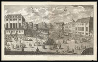
Amsterdam, [c1730].. 565 by 935mm. (22.25 by 36.75 inches).. Engraving with etching, on two sheets joined. View of the Plantage Muidergracht and the Jonas Daniël Meijerplein. The view shown from the present day Mr. Visserplien, the busy intersecti.on in central Amsterdam, depicts the Portuguese Synagogue on the left and the High German or Great Synagogue. These momumental buildings now house the Jewish Historical Museum. The first Jews to settle in Amsterdam were the Sephardim, who had been expelled from Portugal and Spain in 1493. They were joined in the following decades by the Ashkenazi from Central and Eastern Europe, the first of whom had come from Germany in 1600. In those years, the only available land for them was at the outskirts of the eastern side of the Centrum the island of Vlooienburg, surrounded by the Amstel River and the canals so they settled along the island's main street, Breestraat, which quickly became known as Jodenbreestraat. The Great Synagogue (now the Jewish…
Read More Item Price
NZ$15,698.86
NZ$32.04
shipping to USA

America: Lafreri school map of the Americas Il mondo nuovo su chiamato America da Amerigo Vespucci Fiorentino il quale la scopri circa 5 annj doppo Christoforro Colombo...
by VAN SCHOEL, Henricus
- Used
- Condition
- Used
- Quantity Available
- 1
- Seller
-
London, United Kingdom
- Item Price
-
NZ$58,737.25NZ$32.04 shipping to USA
Show Details
Description:
[Rome,: Henricus van Schoel,, 1609].. 425 by 561mm (16.75 by 22 inches).. Double page engraved map, minor expert paper repairs to margins and central fold. A separately-published Lafreri school map of the Americas, the Pacific and Atlantic Oceans, extending to Asia in the west, and Europe in the east with a large land mass labelled 'Terra Australis Incognita' in the south. It is decorated with sea-monsters, a large galleon, and a fine mannerist strapwork cartouche. The map is derivative of Arnoldo di Arnoldi's c1600 map of the same title. Van Schoel's map is detailed and mostly accurate. For example, California is correctly shown as a peninsula, and New Guinea as a separate island; however, Terra Australis, the great unknown south land, awaits discovery. To cover up his lack of knowledge of southern geography, Terra Australis is partially and cleverly covered by the title cartouche. Burden notes that there are a few minor differences between this map and Arnoldi's. For example, in van Schoel's…
Read More Item Price
NZ$58,737.25
NZ$32.04
shipping to USA
More Photos
Atlas universel de geographie physique, politique, statistique et mineralogique: An eight metre globe and the first map of the world on a uniform scale... sur l'echelle de 1/1641836 ou d'une ligne par 1900 toises.
by VANDERMAELEN, Philippe
- Used
- Hardcover
- Condition
- Used
- Binding
- Hardcover
- Quantity Available
- 1
- Seller
-
London, United Kingdom
- Item Price
-
NZ$96,115.50NZ$32.04 shipping to USA
Show Details
Description:
Brussels,, 1827.. 540 by 410mm. (21.25 by 16.25 inches).. 6 volumes. Folio, 6 letterpress half-titles and title-pages, dedication leaf, 42 pages of text, 'Statistique de l'Europe', 7 lithographed index maps, one of comparative heights with contemporary hand-colour in full, and 382 numbered double-page maps, by Henri Ode, with contemporary hand-colour in outline, some very occasional spotting; contemporary half tree calf, drab paper boards, some wear. The maps in the atlas make up the first map of the world on a uniform scale, constructed as a modified conical projection and, if assembled forming a globe with a diameter of 7.75 metres, although only one such was known to have been made, by the author himself, and requiring a specially designed room. "Philippe Vandermaelen was born in Brussels in 1795, the son of a rich soap manufacturer. After his father's death in 1816, he devoted himself to maps and eleven years later produced this quite remarkable atlas. It was totally at his own expense, and like…
Read More Item Price
NZ$96,115.50
NZ$32.04
shipping to USA

More Photos
De uytnemende en seer vvonderlijcke zee-en-landt-reyse van de heer Ludovvyck di Barthema, van Bononien, Ridder &c. Gedaen inde Morgenlanden, Syrien, vrughtbaer en woest Arabien, Perssen, Indien, Egypten, Ethiopien en andere.: The first European to enter Mecca and Medina
by VARTHEMA, Ludvico di
- Used
- Hardcover
- Condition
- Used
- Binding
- Hardcover
- Quantity Available
- 1
- Seller
-
London, United Kingdom
- Item Price
-
NZ$42,718.00NZ$32.04 shipping to USA
Show Details
Description:
Utrecht,: Gerard Nieuwenhuysen & Willem Snellaert,, 1654.. 4to. Engraved frontispiece and 4 engraved plates, plates shaved, head of title-page reinforced, otherwise in good condition. Contemporary vellum. Collation: [8], 56, "56" [= 60], 24, [2, 2 blank] pp. Second Dutch translation of a highly important and adventurous narrative containing the first recorded visit of a non-Muslim to Mecca. Ludovico di Varthema or Barthema (ca. 1468-1517) sailed from Venice to Egypt in 1502 and travelled through Alexandria, Beirut, Tripoli, and Aleppo, arriving in Damascus in April 1503. Here he enrolled in the Mameluke garrison and proceeded overland to Khaybar, Medina and Mekka, thereby becoming the first European to enter the two holiest cities of Islam. His travels took him to South Arabia, Shiraz (Persia), India, Goa, Cochin, and supposedly the Malay isthmus, Sumatra, Banda, the Moluccas, the Spice Islands, Borneo, Java and Malacca. He finally returned to Lisbon in 1508. "Varthema's Itinerario, first…
Read More Item Price
NZ$42,718.00
NZ$32.04
shipping to USA

More Photos
Vraye description des trois voyages de mer tres admirables faicts en trois ans,: Bound in red morocco for "The True Queen of France" a chacun a un, par les navires d'Hollande et Zelande, au nord par derriere Norwege, et Tartarie, vers les royaumes de China & Catay: ensemble les decouvremens du Vvaaygat, Nova Sembla, & du pays famé so
by VEER, Gerrit de
- Used
- Condition
- Used
- Quantity Available
- 1
- Seller
-
London, United Kingdom
- Item Price
-
NZ$106,795.00NZ$32.04 shipping to USA
Show Details
Description:
Amsterdam,: Cornille Nicolas [C. Claesz],, 1604.. Folio (307 by 225mm), ff. 44, with a large title engraving, and 30 engravings in the text, including four engraved maps, one full-page; a few upper margins irregularly cut a bit short with partial loss to headlines; one engraving just shaved at outer margin; small oxidation hole to E2, minimally affecting the engraving on the verso; extreme upper outer corner of one leaf torn away; lightly browned; a few spots and one leaf with an inoffensive stain; bound in late 17th century red morocco; triple gilt fillets to covers, spine gilt, gilt edges; covers with the gilt arms of Marquise de Montespan, and her cypher to corners; marbled end-papers; the binding a bit rubbed; minor scrapes and abrasions to lower cover; two 20th century bookplates on front paste-down, including that of the highly selective Geneva collector, Edmée Maus. Collation: 2 blank, A-L4, 2 blank. The Marquise de Montespan, Françoise Athénaïs de Rochechouart de Mortemart's copy of De…
Read More Item Price
NZ$106,795.00
NZ$32.04
shipping to USA

De Neuwe Platte: Pas: Caart Strekkende: Van: Cumbava tot Tiemoor Anno 1747: Manuscript VOC chart of the islands guarding the southern routes to the Spice Islands
by VEKE, Martinis van der
- Used
- Hardcover
- Signed
- Condition
- Used
- Binding
- Hardcover
- Quantity Available
- 1
- Seller
-
London, United Kingdom
- Item Price
-
NZ$53,397.50NZ$32.04 shipping to USA
Show Details
Description:
[Batavia],, 1747.. 985 by 680mm. (38.75 by 26.75 inches).. Manuscript chart, pen and black ink, and colour wash in outline, on two joined sheets of paper watermarked (lefthand sheet) with Strasburg Lily within a shield, initials "VDL" beneath and countermark "IV" (closest to Churchill 405, dated to 1733, from the mill of Pieter van der Ley, son of Gerrit Pieters van der Ley who worked De Wever - the Weaver - and De Bonsem - the Polecat - mills at Koog aan de Zaan, Holland, from 1674 onwards), and (righthand sheet) Strasburg Lily within a shield with crucifix "4" and "WR" beneath and countermark "IV" (closest to Churchill 406, dated to 1733, from the mill at Egmond in Holland), signed beneath the scale lower right. The Portuguese first settled on Timor in 1520, and the Spanish arrived in 1522. The Dutch took possession of the western portion of the island in 1613. Thereafter, until the twentieth century, the Dutch and the Portuguese struggled for supremacy of the island, with East Timor being…
Read More Item Price
NZ$53,397.50
NZ$32.04
shipping to USA
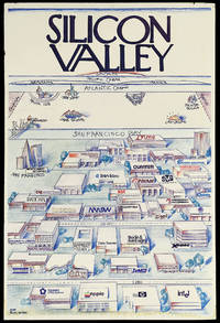
Silicon Valley.: A view of the world from I-280: Silicon Valley's parody of the iconic New Yorker cover
by PACIFIC VENTURES
- Used
- Condition
- Used
- Quantity Available
- 1
- Seller
-
London, United Kingdom
- Item Price
-
NZ$20,291.05NZ$32.04 shipping to USA
Show Details
Description:
[California],: Pacific Ventures,, 1984.. 912 by 610mm. (36 by 24 inches).. Colour printed poster laid down on foamcore. A view of Silicon valley in its early days, parodying Saul Steinberg's classic New Yorker cover, "View of the World from 9th Avenue". This view shows Silicon Valley, and the offices of its important technology companies, looming large in the foreground. Among the companies named are Apple, Hewlett Packard, and Intel. As the view recedes across San Francisco bay, there is a humorously foreshortened view of North America, with much smaller views of Lake Tahoe, Las Vegas, New York, and Boston (with, of course, MIT). North Carolina and Texas' computer industry centres are competitively nodded at as well, with Piedmont, NC's Research Triangle and Austin's Silicon Gulch both shown. Further in the distance is the Atlantic Ocean, with France and Germany shown as long islands, followed by the Pacific Ocean, culminating in Japan. "Silicon Valley" is written at the top of the image in the…
Read More Item Price
NZ$20,291.05
NZ$32.04
shipping to USA
![Kunyu quantu [A Complete Map of the World].](https://d3525k1ryd2155.cloudfront.net/h/275/506/1391506275.0.m.jpg)
More Photos
Kunyu quantu [A Complete Map of the World].: One of the largest world maps ever printed
by VERBIEST, Ferdinand
- Used
- Condition
- Used
- Quantity Available
- 1
- Seller
-
London, United Kingdom
- Item Price
-
NZ$384,462.00NZ$32.04 shipping to USA
Show Details
Description:
[Beijing, 1674, but reprinted Seoul,, 1860].. 1500 by 3000mm. (59 by 118 inches).. Xylograph, printed on 6 sheets, the southern polar landmass embellished with animals, including a unicorn, a lion, a rhinoceros, a crocodile, a giraffe, a beaver and a turkey, the spandrels with eight large lozenges with text descriptions. Verbiest's original is as rare as its forerunner produced by Matteo Ricci at Beijing in 1602 (or its now-lost predecessors). Kunyu quantu (A Map of the Whole World), was first produced in 1674 by the Jesuit Father Ferdinand Verbiest (1623-1688). Commissioned by the Second Qing Emperor Kangxi (1654-1722, r. 1661- 1722), it is one of the largest woodblock-printed maps of its type. It consists of two hemispheres, reversing the conventional European positioning so that China and the Pacific are toward the centre, with the prime meridian running through Beijing. Cartouches are depicted surrounding the hemispheres containing information on the size, climate, landforms, customs…
Read More Item Price
NZ$384,462.00
NZ$32.04
shipping to USA

Regis Christianissimi Geographus Ordiniarius, 1698.
by VERMEULEN, [Cornelis]; [after] CULIN
- Used
- Condition
- Used
- Quantity Available
- 1
- Seller
-
London, United Kingdom
- Item Price
-
NZ$2,563.08NZ$32.04 shipping to USA
Show Details
Description:
[Paris]: [Cornelis] Vermeulen Sculpsit. , 1698.. 365 by 300mm. (14.25 by 11.75 inches).. Prints,""Alexius Hubertus Iaillot, Alexis Hubert Jaillot Engraved portrait, trimmed to plate mark. In 1657, Alexis-Hubert Jaillot (1632-1712) travelled to Paris with his brother in response to Louis XIV's summons to the country's artists and scientists to settle in the capital, hoping to make it the centre of European art and learning. Having initially made a living as a sculptor, Jaillot turned to cartography after marrying the daughter of mapmaker Nicholas Berey. At the beginning of the 1670s, he formed a partnership with the sons and heirs of Nicholas Sanson, who had been the most important French cartographer to date; Jaillot set about re-engraving and enlarging many of Sanson's plates, a number of which had never been published. From 1681 onwards, he compiled and published these in his 'Atlas Nouveau' which proved hugely successful, running to numerous editions and translations through the remainder of…
Read More Item Price
NZ$2,563.08
NZ$32.04
shipping to USA

Civitas Londinum Ano Dni Circiter MDLX.: Elizabethan London depicted Londinum Antiqua. This Plan shews the ancient extent of the famous Cities of London and Westminster as it was near the begining of the Reign of Queen Elisabeth these Plates for their great scarcity are re-ingraved to Oblidge th
by VERTUE, George, [after] Ralph AGAS
- Used
- Condition
- Used
- Quantity Available
- 1
- Seller
-
London, United Kingdom
- Item Price
-
NZ$12,815.40NZ$32.04 shipping to USA
Show Details
Description:
[London],: George Vertue,, 1737.. 2040 by 760mm (80.25 by 30 inches).. Engraved plan on eight sheets. A large, highly detailed re-creation of Elizabethan London. As is explained here, although this work was actually published in the eighteenth century, it is still one of only three known printed depictions of London from the sixteenth century. It captures the City as it was developing beyond its original walls, but with farms and pastures still much in evidence nearby. Deer can still be seen in St. James Park. The major roads of entry to the city are shown and named, many of which are now-well known thoroughfares within the city. Many streets shown in the plan also bear names familiar to us. Much of the City of London's wall is still intact, and the Tower complex is well detailed. At the very lower left is Westminster Abbey, and just to the north is Scotland Yard, which contains a curious, smoking, dome structure, perhaps for the heating of tar for caulking ships. St. Paul's Cathedral is shown…
Read More Item Price
NZ$12,815.40
NZ$32.04
shipping to USA

Makes curious Sets of Scales & Weights for Diamonds Also Assay Scales - and Scales & Weights for ye Gold Current Coin. Likewise all sorts of Beam Scales & Weights for Grocers &c. & keeps them in repair by the Year. Also Steel-yards made in the most compleat [sic] manner. Brass Cocks, Wholesale & Retail at the lowest Prices By the Maker.
by VINCENT, Robert
- Used
- Condition
- Used
- Quantity Available
- 1
- Seller
-
London, United Kingdom
- Item Price
-
NZ$4,271.80NZ$32.04 shipping to USA
Show Details
Description:
[London],: At the Hand & Scales on London Bridge the Second Door from the Bear Tavern, Southwark-Side, , [before 1761]. 165 by 110mm (6.5 by 4.25 inches).. Prints,""Scale-Maker... S is for Scale Maker Engraved trade card. Vincent (fl 1760-17930 seems to have had a long and prosperous career, as Heal writes of his example of Vincent's trade card: """"The Bear Tavern was pulled down in December 1761. It stood on the Western side of the Bridge Foot nearly opposite Tooley Street"""". In the 'London Directory' for 1784, Robert Vincent is still described as of 'London Bridge'. In the 1793 'London Directory' he is given at No.1, High Street, Borough, and in the 1802 issue, the style and address of the business is 'Vincent & Chancellor, No.1, Bridge Foot, Borough. BM Heal 103.27
Item Price
NZ$4,271.80
NZ$32.04
shipping to USA
Anno Aetatis 74 Obijt Decem: 31 1719.
by VIRTUE, Geo[rge]; after T[homas] GIBSON
- Used
- Condition
- Used
- Quantity Available
- 1
- Seller
-
London, United Kingdom
- Item Price
-
NZ$640.77NZ$32.04 shipping to USA
Show Details
Description:
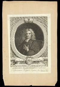
[London,: George Vertue,, c1721].. 328 by 224mm. (13 by 8.75 inches).. Prints,""Johannes Flamsteedius Derbiensis Astronomiae Professor Regius John Flamsteed Engraved portrait. John Flamsteed (1646 - 1719) was best-known for compiling a 3,000-star catalogue, 'Catalogus Britannicus', and a star atlas entitled 'Atlas Coelestis', both published posthumously. Upon being made the first Royal Astronomer in 1675 by Charles II, Flamsteed was charged with """"rectifieing the Tables of the motions of the Heavens, and the places of the fixed stars, so as to find out the so much desired Longitude of places for Perfecteing the Art of Navigation"""". Although the longitude problem would not be solved for another sixty years, Flamsteed's works were a great contribution to seventeenth century astronomy. The present half-length portrait shows Flamsteed sitting with one hand at his breast in a sign of sincerity and honour, dressed in an academic gown with bands at his neck, and wearing a peruke. It was published as…
Read More Item Price
NZ$640.77
NZ$32.04
shipping to USA

Onderwysing van't Gebruyk des Hemels Pleyn: Vooght's rare star chart and astronomical calculator Waar op de starren des hemels na 't oogh in 't plat gestelt zyn[.] Tot nut en vermaak van alle liefhebbers der wiskonsten.
by VOOGHT, Claes Jansz. [after] Jan Jansz STAMPIOEN
- Used
- Hardcover
- Condition
- Used
- Binding
- Hardcover
- Quantity Available
- 1
- Seller
-
London, United Kingdom
- Item Price
-
NZ$85,436.00NZ$32.04 shipping to USA
Show Details
Description:
Amsterdam,: Johannis van Keulen,, [c1680-1696].. 560 by 660mm. (22 by 26 inches).. Large engraved celestial chart with a rotating printed paper ring (volvelle or rete) on an off-centre axis to indicate the part of the sky visible at any date and time and to make a variety of celestial calculations, all for the Netherlands' latitude of 52 degrees. A string with two beads serves as a pointer for aligning the scales in the stationary and rotating parts. With engraved instructions also by Vooght. Coloured by a contemporary hand and mounted on contemporary boards covered with marbled paper, apparently by the publisher, so that it can be folded in half for carrying. The string may be a modern replacement. Vooght's rare star chart and astronomical calculator, here separately issued in portfolio form and in its first state. The chart shows the stars visible from 52 degrees latitude in a polar equidistant projection, with a rotating volvelle or rete to indicate the part of the sky visible at a particular…
Read More Item Price
NZ$85,436.00
NZ$32.04
shipping to USA
![[Antwerp] Antverpia Totius Inferiorsae Primaria Urbs Germaniae Nobilissima et Ducatus Brabanti.](https://d3525k1ryd2155.cloudfront.net/h/187/910/1162910187.0.m.jpg)
More Photos
[Antwerp] Antverpia Totius Inferiorsae Primaria Urbs Germaniae Nobilissima et Ducatus Brabanti.: Seventeenth century Antwerp
by VRIENTS, Jan Baptist
- Used
- Condition
- Used
- Quantity Available
- 1
- Seller
-
London, United Kingdom
- Item Price
-
NZ$53,397.50NZ$32.04 shipping to USA
Show Details
Description:
Amsterdam,: Claes Jansz Visscher,, 1652.. 580 by 2220mm (22.75 by 87.5 inches).. Large engraved panorama, on four sheets joined, contemporary full wash colour, woodcut title in six sections pasted above, three panels of descriptive letterpress text composed of six half-sheets pasted outside the lower border, previously laid on canvas, some restoration with manuscript reinstatement and retouching, relaid on a modern board backing, with stretchers, the title wrongly reassembled after restoration, should be: "Antverpia totius Inferioris Germaniæ nobilissima et ducatus Brabantiæ primaria urbs". A rare and finely engraved prospect of Antwerp viewed from the Scheldt, first published by Vrients in 1610, under a privilege issued by Albert and Isabella, Archduke and Archduchess of Austria, governors of the Austrian Netherlands. The plates later came into the hands of the Visscher family, and were reprinted by Claes Jansz. Visscher the younger, presumably Nicolaas Visscher I. This is, apparently, one of…
Read More Item Price
NZ$53,397.50
NZ$32.04
shipping to USA

Didn’t find what you’re looking for?
Try adding this search to your want list. Millions of books are added to our site everyday and when we find one that matches your search, we’ll send you an email. Best of all, it’s free.
Add to Want List

Are you a frequent reader or book collector?
Join the Bibliophile's Club and save 10% on every purchase, every day — up to $20 savings per order!

Social Responsibility
Did you know that since 2004, Biblio has used its profits to build 16 public libraries in rural villages of South America?
