Description:
London, : G. W. Bacon & Co., Ltd., 127 Strand,, [c1899].. 560 by 755mm. (22 by 29.75 inches).. Lithograph map in full-colour, with three inset maps, laid on cardboard, two small holes on right border with minimal effect on image. This rare map of the Transvaal, or the South African Republic, was produced and sold to the general public in London, at a time when the British Empire was approaching the pinnacle of its global influence. Made in 1899, it displays the southern African states on the verge of the Second Boer Wars, which would see the Transvaal transformed from an independent republic to a British possession. Despite its nominal focus on the South African Republic, the map predictably gives special prominence to the British colonies, represented in pink. The same is true of the inset maps along the right border: Cape Colony is labelled in the largest script on the map of Africa, and similarly, the map that claims to show Orange Free State is actually dominated by the British territory. The…
Read More Search Results: Titles starting with B from Daniel Crouch Rare Books Ltd
You searched for:
- Bookseller inventory: Daniel Crouch Rare Books Ltd (titles starting with B)
- Bookseller: Daniel Crouch Rare Books Ltd
Results 1 - 20 of 27

Bacon's large-print map of the Transvaal: Bacon's rare map of the Transvaal
by BACON, G[eorge], W[ashington]
- Used
- Condition
- Used
- Quantity Available
- 1
- Seller
-
London, United Kingdom
- Item Price
-
NZ$212.36NZ$31.85 shipping to USA
Show Details
Item Price
NZ$212.36
NZ$31.85
shipping to USA
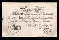
Bank of Love. Promise (67579) to pay to you on demand (67579) the entire Love of the supplicant who sends this. 1868 Feb.y. 14. Temple of Hymen 14 Feb.y 1868. For the Gov.r and Compy:a of the Bank of Love. Cupid.: Cashing in at the Bank of Love
by [ANONYMOUS]
- Used
- Condition
- Used
- Quantity Available
- 1
- Seller
-
London, United Kingdom
- Item Price
-
NZ$1,061.80NZ$31.85 shipping to USA
Show Details
Description:
[London,, 1868].. 130 by 210mm. (5 by 8.25 inches).. Bank note, creased, a few tears skilfully repaired. A Valentine's Day promissory note, published for the 14th February, 1868. The note is in the form of the five pound bank notes issued by the Bank of England in the nineteenth century. Whereas the bank of England promised to pay the bearer of the note five pounds worth of gold. The bear of this note can expect "the entire Love of the supplicant who sends this". The note is endorsed by none other than Cupid, Chairman of the Bank of Love, who's head office is located at the Temple of Hymen.
Item Price
NZ$1,061.80
NZ$31.85
shipping to USA

Bankers Notes, Checks, Bills of Exchange &c. Arms Crests &c. Brass & Zinc Door Plates, Book Plates.
by SMITH, H.D.
- Used
- Condition
- Used
- Quantity Available
- 1
- Seller
-
London, United Kingdom
- Item Price
-
NZ$955.62NZ$31.85 shipping to USA
Show Details
Description:
London,: 3 Gough Square, Fleet Street, , [c1860]. 80 by 110mm (3.25 by 4.25 inches).. Prints,""H.D. Smith, Engraver & Printer,... Z is for Zincographer Lithographed trade card This very grand trade card appears to be the only example known, and also the only evidence that H.D. Smith operated as an engraver and printer. From 1832, 3 Gough Square, near Fleet Street, had been occupied by Richard Gilson Reeve (1803-1889), a renowned engraver and publisher of aquatints, from an artistic family.
Item Price
NZ$955.62
NZ$31.85
shipping to USA

Bauerkeller's New Embossed Plan of London 1841: George Bauerkeller's rare and strikingly modern embossed plan of London with its Index
by BAUERKELLER, G[eorge]
- Used
- Condition
- Used
- Quantity Available
- 1
- Seller
-
London, United Kingdom
- Item Price
-
NZ$15,927.00NZ$31.85 shipping to USA
Show Details
Description:
Paris & London,: Published by Ackerman & Co., 96 Strand,, 1841.. 680 by 1160mm. (26.75 by 45.75 inches).. Hand-coloured engraved embossed map, dissected and mounted on linen, inset of the Isle of Dogs, tables of the population of London and key to the maps colouring, folding into brown paper slipcase, with tree branch pattern. This extraordinary embossed plan shows each locality in a different colour and built up areas raised in white, similar to the technique of Braille. Extending from Islington in the north to Kennington in the south and from Kensington High Street in the west to the West India Docks, with an inset of Greenwich at a smaller scale. A unique style of cartography in very good condition. In an advertisement in the 'Sporting Magazine Advertiser' Ackermann announces its publication: '... The Buildings are raised, and, with the Railroads, Parks, Squares, &c. apper very prominent. The Parishes are also distinguished in delicate tints., and the entire arrangement is so remarkably…
Read More Item Price
NZ$15,927.00
NZ$31.85
shipping to USA

Bauerkeller's New Embossed Plan of London 1841.: George Bauerkeller's rare and strikingly modern embossed plan of London
by BAUERKELLER, G[eorge]
- Used
- Condition
- Used
- Quantity Available
- 1
- Seller
-
London, United Kingdom
- Item Price
-
NZ$14,865.20NZ$31.85 shipping to USA
Show Details
Description:
Paris & London,: Published by Ackerman & Co., 96 Strand,, 1841.. 680 by 1160mm. (26.75 by 45.75 inches).. Hand-coloured engraved embossed map, dissected and mounted on linen, inset of the Isle of Dogs, tables of the population of London and key to the maps colouring, folding into brown paper slipcase, with tree branch pattern. This extraordinary embossed plan shows each locality in a different colour and built up areas raised in white, similar to the technique of Braille. Extending from Islington in the north to Kennington in the south and from Kensington High Street in the west to the West India Docks, with an inset of Greenwich at a smaller scale. A unique style of cartography in very good condition. In an advertisement in the 'Sporting Magazine Advertiser' Ackermann announces its publication: '... The Buildings are raised, and, with the Railroads, Parks, Squares, &c. apper very prominent. The Parishes are also distinguished in delicate tints., and the entire arrangement is so remarkably…
Read More Item Price
NZ$14,865.20
NZ$31.85
shipping to USA

The Bay of Alfaques: Alfaques Bay near Tortosa in Valencia, Drawn by Capt. Doleman in Jan. 1705/6
by DOLEMAN
- Used
- Condition
- Used
- Quantity Available
- 1
- Seller
-
London, United Kingdom
- Item Price
-
NZ$1,061.80NZ$31.85 shipping to USA
Show Details
Description:
London,: Richard Mount,, c.1706.. 250 by 358mm. (9.75 by 14 inches).. Engraved map. Captain Doleman was an officer in the English Royal Navy, serving with the Navy off the coast of Valencia during the Spanish campaign of 1705/1706; the Post Boy (issue 1597) for 6th - 9th April 1706 records his capture of a supply ship, detailed in a report by the Surgeon General serving with the Earl of Peterborough's army, "Valencia, Feb. 6,... The Enemy retired about 3 leagues from us, I suppose in expectation to be joyned by 250 men, 6 pieces of Cannon, 150 Barrels of Powder, and Shot proportionable which was coming to them by Sea; but the Lyme Man of War, Capt. Doleman, Commander, had the good Fortune to meet and take them, and carried them into Denia. ...". This small chart of Alfaques Bay was evidently compiled about this time and given (or sold) to the London chart-publisher, Richard Mount, senior partner of Mount and Page; it may be that members of the armed services supplemented their pay by providing…
Read More Item Price
NZ$1,061.80
NZ$31.85
shipping to USA

Bay of Bengal.: Rare chart of the Bay of Bengal Plans of the Principal Harbours, Drawn From Surveys made by order of The Hon: East India Compy. the Board of Admiralty, &c.
by IMRAY, James
- Used
- Condition
- Used
- Quantity Available
- 1
- Seller
-
London, United Kingdom
- Item Price
-
NZ$1,061.80NZ$31.85 shipping to USA
Show Details
Description:
London,, 1864.. 1025 by 1320mm. (40.25 by 52 inches).. Blueback chart. Rare large sea chart of the Bay of Bengal and environs, published in 1648 by James Imray. The map provides a fine treatment of the region, including a number of large harbor insets and notes with sailing directions, tidal observations, etc.
Item Price
NZ$1,061.80
NZ$31.85
shipping to USA
![[Bay of Nagasaki].](https://d3525k1ryd2155.cloudfront.net/h/409/505/1391505409.0.m.jpg)
[Bay of Nagasaki].: Manuscript Bay of Nagasaki
by KEULEN, Johannes van
- Used
- Condition
- Used
- Quantity Available
- 1
- Seller
-
London, United Kingdom
- Item Price
-
NZ$106,180.00NZ$31.85 shipping to USA
Show Details
Description:
Amsterdam,, 1750.. 505 by 580mm. (20 by 22.75 inches).. Manuscript map in brown ink and wash colours, contemporarily laid down on paper. During the period 1726-1755, when Johannes van Keulen II (17041755) was in charge as Hydrographer of the V.O.C., the first charts for the navigation to the East Indies and in the Malaysian Archipelago were engraved. Such charts printed or in manuscript are sometimes found as additions to copies of the Zee-Fakkel. They mark the beginning of what was to become the pilot guide for the East Indies. Several of the charts in the sixth part of the Zee-Fakkel were engraved after the manuscript master-models in the archives of the V.O.C. It was a common practice for the van Keulens to print sheets with a system of rhumblines and latitude scales, to be used as a base for manuscript maps. However, surviving examples, particularly of Far Eastern subjects are very scarce. This chart depicting Nagasaki seems to have been inserted in an example of the atlas, presumably in…
Read More Item Price
NZ$106,180.00
NZ$31.85
shipping to USA

Bedfordshire: Rare Roger Rea edition of Speed's map of Bedfordshire and the situation of Bedford described with the armes of thos Honourable Familyes that have bourne ye titles of Dukes and Earls thereof.
by SPEED, John
- Used
- Condition
- Used
- Quantity Available
- 1
- Seller
-
London, United Kingdom
- Item Price
-
NZ$2,123.60NZ$31.85 shipping to USA
Show Details
Description:
[London],: to be sold by Roger Rea the Elder and younger at ye Golden Crosse in Cornhill against ye Exchange,, 1665.. 410 by 550mm. (16.25 by 21.75 inches).. Double-page engraved map, fine contemporary outline hand colour, slight loss to gutter. The map bears the imprint of Roger Rea the Elder and Younger. The Reas had purchased the rights to Speed's work from William Garrett in 1659, who had previously purchased them from the widow of William Humble in the same year. Skelton suggests that the father and son intended a new edition of the atlas for the Restoration, of 1660. However, the atlas would appear not to have been published until 1665. This is borne out by an advertisement in the Term Catalogue by the subsequent owners of the plates, Thomas Bassett and Richard Chiswell, in 1675: "Mr John Speed's... Geography of the Kingdoms of England, Scotland, and Ireland... together with his Prospect... all in one entire Volume, hath been, for seven Years past, out of Print, the greatest part of an…
Read More Item Price
NZ$2,123.60
NZ$31.85
shipping to USA

More Photos
Bett's Patent Portable Terrestrial Globe.: Shape-shifting cartography Compiled from the latest and best authorities.
by BETTS, John
- Used
- Condition
- Used
- Quantity Available
- 1
- Seller
-
London, United Kingdom
- Item Price
-
NZ$3,822.48NZ$31.85 shipping to USA
Show Details
Description:
[London,: George Philip & Son Ltd.,, 1860].. Collapsible globe, eight linen gores clipped at a latitude of 80 degrees, printed by colour lithography, sewn together with metal guides at edges, extendable into the sphere by means of umbrella mechanism, housed in wooden box with original labels. "The idea of an inexpensive, portable globe for teaching had been suggested in the late 18th century. Richard and Maria Edgeworth, a father-daughter pair of educationalists, asked in their 1798 publication Practical Education: 'Might not a cheap, portable, and convenient globe be made of oiled silk, to be inflated by a common pair of bellows?' It was another forty years, however, until such a globe was first produced. Their request was answered in around 1830 with the invention of the balloon globe, an object made of fabric gores stitched together, which was inflated with an air pump. However, in 1850, John Betts designed an attractive alternative that did not require being inflated with a pump. Betts' "New…
Read More Item Price
NZ$3,822.48
NZ$31.85
shipping to USA

More Photos
Bill-heads and Circulars, Drawn, Copied, Written & taken off by Alfred Pocock, Broad Street, Wine Street, Bristol
by POCOCK, Alfred
- Used
- Condition
- Used
- Quantity Available
- 1
- Seller
-
London, United Kingdom
- Item Price
-
NZ$1,805.06NZ$31.85 shipping to USA
Show Details
Description:
[Bristol,, c1860].. 300 by 208mm. (11.75 by 8.25 inches).. Prints,""Lithography, Engraving and Printing, Drawings of Every Description, Elevations, Plans, Maps, Pocock's Premises Lithohgraph, printed recto and verso, trimmed. Advertisement for Alfred Pocock's Bristol print shop, consisting of a view of his premises, with a printed text on the reverse. In this text Pocock explains his reasons for """"having lately enlarged his Establishment"""" and describes the lithographic services provided. Pocock also supplied materials for practising lithographers and in addition offers """"directions given to assist Young Practitioners"""". Alfred Pocock (1814-97) was known for his local views and views of Australia. He was also a keen cricketer, who apart from being a founder member of the club which became Gloucestershire CCC, gave W.G. Grace his first coaching. A. Baynton-Williams & Laurence Worms, 'British Map Engravers'.
Item Price
NZ$1,805.06
NZ$31.85
shipping to USA

Bird's Eye View of the General Line of the Tottenham and Farringdon Street Extension Railway: Tottenham and Farringdon Extension Railway From the end of Hatton Garden passing though Clerkenwell, Islington, Stoke Newington and Clapton.
by [T. A.]
- Used
- Condition
- Used
- Quantity Available
- 1
- Seller
-
London, United Kingdom
- Item Price
-
NZ$530.90NZ$31.85 shipping to USA
Show Details
Description:
[London],: Day & Haghe, Lithrs. to the Queen, [c.1845].. Image: 337 by 528mm (13.25 by 20.75 inches). Sheet: 400 by 555mm (15.75 by 21.75 inches).. Lithograph, right margins trimmed to image, left margin trimmed with inch loss to image. A view of the proposed railway line, put forward by the short-lived Tottenham and Farringdon Street Junction Railway Company. The line met with a great deal of resistance and and was never built. William Day (1797-1845) and Louis Haghe (1806-1885) formed a partnership which became one of the largest British lithographic firms of the nineteenth century, and was successful enough to gain a royal warrant in 1838. After William's death in 1845 the company was run by his son W.J. Day, and in in the early 1850s when Louis Haghe left to concentrate on watercolours the firm became known as Day and Sons.
Item Price
NZ$530.90
NZ$31.85
shipping to USA
![[Bird's-eye View of Amsterdam, first printed in Amsterdam in 1544, 3rd edition, 1553 or later].](https://d3525k1ryd2155.cloudfront.net/h/209/506/1391506209.0.m.jpg)
[Bird's-eye View of Amsterdam, first printed in Amsterdam in 1544, 3rd edition, 1553 or later].: The first printed plan of Amsterdam Text in the cartouche in the upper right: De vermaerde koopstadt/van Amstelredam/ geconterfeyt met alle sijn Wateren/ Bruggen / Straten /Kercken /Kloo=steren/ Huysen /Toorens /Poorten ende Mueren / ende omleggende situ
by ANTHONISZ, Cornelis
- Used
- first
- Condition
- Used
- Quantity Available
- 1
- Seller
-
London, United Kingdom
- Item Price
-
NZ$743,260.00NZ$31.85 shipping to USA
Show Details
Description:
Amsterdam,, 1544 [1553 or later].. Dimensions (if joined) 1065 by 1095mm. (42 by 43 inches). Individual sheet measurements: (297 by 378mm; 242 by 387mm; 283 by 378mm; 287 by 392mm; 305 by 392mm; 287 by 387mm; 302 by 374mm; 304 by 387mm; 242 by 387mm; 304 by 393mm; 245 by 378mm; 308 by 387mm). Large wall map, woodcut with handcut and letterpress lettering on twelve sheets, mounted on linen. Watermark (on several sheets): A yet unidentified foolscap with four pointed extensions and two shorter ones with bells, including an elongated staff with three balls. Not identified in Churchill, Laurentius, Voorn or Heawood. Condition: overall fine condition, untrimmed, and in loose sheets, some sheets a bit darkened in the corners, a few small areas of restoration to margins, perhaps pressed at some stage, apparently once framed (some dark lines in the margins do suggest this), very clean, printed on thin paper. The first printed plan of Amsterdam. Cornelis Anthonisz (1499-c1557) was a distinguished…
Read More Item Price
NZ$743,260.00
NZ$31.85
shipping to USA

Bootlegger's Map of the United States. Honi soit qui mal y pints!: The wet, the dry and the hypocrites!
by [MCCANDLISH, Edward]
- Used
- Condition
- Used
- Quantity Available
- 1
- Seller
-
London, United Kingdom
- Item Price
-
NZ$3,185.40NZ$31.85 shipping to USA
Show Details
Description:
[Detroit, Michigan],: Griswold Press,, [c1926].. 550 by 870mm (21.75 by 34.25 inches).. Lithograph map on two map sheets joined. McClandish's satirical map of America became one of the best known and most widely circulated maps of the prohibition era. It depicts the United States as an alcohol-sodden explosion of illicit activity, with smugglers covertly carrying barrels of beer over the Canadian border, and supply boats off the East coast providing necessary relief for victims of the era's liquor ban. Originally published in full colour for the Washington Post in 1926, the image soon grew so popular that it was separately issued as a broadsheet poster by Griswold Press in Detroit, of which the present map is an example. In addition, Hagstrom Company continued to produce a fully coloured linen-backed version, designed to ornament the rooms of "games rooms, fraternity houses, dormitory rooms, or private bars" (Hornsby), which remained in print for the following two decades. The map was also syndicated…
Read More Item Price
NZ$3,185.40
NZ$31.85
shipping to USA

More Photos
and Borough of Southwark, with the contiguous buildings; engraved by John Pine Bluemantle Pursuivant at Arms, and Chief Engraver of Seals, &c. to His Majesty; from a actual Survey made by John Rocque; And printed on Twenty-four Sheets of Imperial Paper; With References for the easy finding the said Places.
by ROCQUE, John
- Used
- Hardcover
- Condition
- Used
- Binding
- Hardcover
- Quantity Available
- 1
- Seller
-
London, United Kingdom
- Item Price
-
NZ$3,185.40NZ$31.85 shipping to USA
Show Details
Description:
London,: Printed for John Pine, at the Golden Head oppsite Burlington House in Piccadilly; and John Tinney, at the Golden Lyon in Fleet Street,, 1747.. 280 by 225mm. (11 by 8.75 inches).. Maps,""An Alphabetical Index of the Streets, Squares, Lanes, Alleys, &c. contained in the Plan of the Cities of London and Westminster, Rocque's Index to his monumental 24-sheet plan of London Quarto. Modern grey paper boards, title to spine. Collation: i-xii, pp.46, index, table of contents. In the preface to the work Rocque sets out the urgent need for an accurate plan of London, in order to settle once and for all the argument of which was large Paris or London. Rocque goes on to discuss the surveying techniques used, and the encouragement they gained from the Mayor of London in his endeavour. The preface is followed by list of subscribers, an explanation to the index and and a forty-six page list of alleys, banks, barns, barracks, bars, bridges, buildings, buries, and butts; closes, commons, corners, courts,…
Read More Item Price
NZ$3,185.40
NZ$31.85
shipping to USA

Brasilia et Peruvia.: De Jode's map of South America
by JODE, Cornelius de
- Used
- Condition
- Used
- Quantity Available
- 1
- Seller
-
London, United Kingdom
- Item Price
-
NZ$25,483.20NZ$31.85 shipping to USA
Show Details
Description:
Antwerp,, 1593.. 362 by 426mm. (14.25 by 16.75 inches).. Double page engraved map. A fine example of de Jode's second map of South America. The map shows part of Central America and the whole of South America, including a large landmass representing the Tierra del Fuego merging into Australia. It is one of the earliest maps to show the continent on its own, and the earliest Dutch map of South America. The Southern American continent's interior is densely detailed with many place names, annotations and images describing the territory, its people, and the flora and the fauna. Two vignettes show life at a cannibal's campsite, including a human-based dinner, and a battle between indigenous people armed with bows and arrows and explorers armed with rifles. The seas are filled with several vessels, boats, monsters, and more annotations. The map appeared in the second edition of the de Jodes' atlas 'Speculum orbis terrae'. The 'Speculum' was first published in 1578 by Gerard de Jode (1509-1591) with…
Read More Item Price
NZ$25,483.20
NZ$31.85
shipping to USA

Brasilia et Peruvia.: De Jode's map of South America in original colour
by DE JODE, Cornelis
- Used
- Condition
- Used
- Quantity Available
- 1
- Seller
-
London, United Kingdom
- Item Price
-
NZ$31,854.00NZ$31.85 shipping to USA
Show Details
Description:
Antwerp,, 1593.. 362 by 426mm. (14.25 by 16.75 inches).. Double page engraved map, fine original hand colour. A fine original colour example of de Jode's second map of South America. The map shows part of Central America and the whole of South America, including a large landmass representing the Tierra del Fuego merging into Australia. It is one of the earliest maps to show the continent on its own, and the earliest Dutch map of South America. The Southern American continent's interior is densely detailed with many place names, annotations and images describing the territory, its people, and the flora and the fauna. Two vignettes show life at a cannibal's campsite, including a human-based dinner, and a battle between indigenous people armed with bows and arrows and explorers armed with rifles. The seas are filled with several vessels, boats, monsters, and more annotations. The map appeared in the second edition of the de Jodes' atlas 'Speculum orbis terrae'. The 'Speculum' was first published in…
Read More Item Price
NZ$31,854.00
NZ$31.85
shipping to USA
![[Brecknockshire] Breknoke](https://d3525k1ryd2155.cloudfront.net/h/994/909/1162909994.0.m.jpg)
[Brecknockshire] Breknoke: Speed's map of Brecknockshire both shyre and towne described.
by SPEED, John
- Used
- Condition
- Used
- Quantity Available
- 1
- Seller
-
London, United Kingdom
- Item Price
-
NZ$1,061.80NZ$31.85 shipping to USA
Show Details
Description:
London,: Performed by Iohn Speede and are to be solde in Popes head alley against the Exchange by I Sudbury and George Humbell,, [1627].. 385 by 510mm. (15.25 by 20 inches).. Engraved map with hand colouring. A beautifully coloured map of the historic county of Brecknockshire, with an inset map of the city of Brecon. John Speed (1552-1629) was the outstanding cartographer of his age. His 'Theatre of Great Britain' was the first atlas of the British Isles: Speed prepared the maps himself about two years before they were published. His maps and books dominated the seventeenth-century English market. The present map is taken from the 1627 English edition published by George Humble. Chubb XXV.
Item Price
NZ$1,061.80
NZ$31.85
shipping to USA

Britain As It Was Devided in the tyme of the Englishe Saxons especially during their Heptarchy: Rare Roger Rea edition of Speed's Heptarchy Performed by Iohn Speede.
by SPEED, John
- Used
- Condition
- Used
- Quantity Available
- 1
- Seller
-
London, United Kingdom
- Item Price
-
NZ$8,069.68NZ$31.85 shipping to USA
Show Details
Description:
[London],: are to be sold by Roger Rea ye Elder and younger at ye Golden Crosse in Cornhill against ye Exchange,, [1665].. 410 by 550mm. (16.25 by 21.75 inches).. Double-page engraved map, fine contemporary outline hand colour, upper left and right margin skilfully repaired. The map bears the imprint of Roger Rea the Elder and Younger. The Reas had purchased the rights to Speed's work from William Garrett in 1659, who had previously purchased them from the widow of William Humble in the same year. Skelton suggests that the father and son intended a new edition of the atlas for the Restoration of 1660. However, the atlas would appear not to have been published until 1665. This is borne out by an advertisement in the Term Catalogue by the subsequent owners of the plates, Thomas Bassett and Richard Chiswell, in 1675: "Mr John Speed's... Geography of the Kingdoms of England, Scotland, and Ireland... together with his Prospect... all in one entire Volume, hath been, for seven Years past, out of Print,…
Read More Item Price
NZ$8,069.68
NZ$31.85
shipping to USA
![[British Legation Peking].](https://d3525k1ryd2155.cloudfront.net/h/782/505/1391505782.0.m.jpg)
More Photos
[British Legation Peking].: A collection of contemporary documents from the Boxer Rebellion
by [ANONYMOUS]
- Used
- Condition
- Used
- Quantity Available
- 1
- Seller
-
London, United Kingdom
- Item Price
-
NZ$3,185.40NZ$31.85 shipping to USA
Show Details
Description:
[Peking,, c1900].. (map) 340 by 261mm. (13.5 by 10.25 inches).. Manuscript map (227 by 175mm) in pencil and coloured pencil, with ink annotations, minor foxing, pasted on paper. Contemporary newspaper clipping affixed to upper left corner with pin. Two photographs (86 by 295mm) pasted to verso, sun-spotted, bleached and toned. Separate sheet with two photographs pasted to front, one to verso, in same condition. This unique manuscript plan of the Peking Legation Quarter records the positions of the two opposing sides during the most tense conflict of the Boxer Rebellion. The Yihetaun Movement was a violent uprising in China at the turn of the twentieth century, inspired by the proto-nationalist sentiments of United in Righteousness, a militant group commonly referred to as 'Boxers'. They condemned the presence of colonial and Christian influences in the country, and were incensed by the disruption that had resulted from the growth of foreign powers. Their activities grew increasingly violent…
Read More Item Price
NZ$3,185.40
NZ$31.85
shipping to USA

Didn’t find what you’re looking for?
Try adding this search to your want list. Millions of books are added to our site everyday and when we find one that matches your search, we’ll send you an email. Best of all, it’s free.
Add to Want List

Are you a frequent reader or book collector?
Join the Bibliophile's Club and save 10% on every purchase, every day — up to $20 savings per order!

Social Responsibility
Did you know that since 2004, Biblio has used its profits to build 16 public libraries in rural villages of South America?
