Description:
[Augsburg,: Bürglen,, 1805].. 185 by 144mm. (7.25 by 5.75 inches).. Prints,""J. J. Scheuchzerus Johann Jakob Scheuchzer Engraved portrait. Johann Jakob Scheuchzer (1672-1733) published 34 original works and numerous articles on the subjects of history, science and travel; his subscribers included some of the most notable names of the day, such as Isaac Newton and Hans Sloane. After extensive journeys throughout his native Switzerland, he published a four sheet map of the country in 1712, the same year that a civil war toppled the Old Swiss Confederacy and ended Catholic hegemony. Until the end of the eighteenth century, Scheuchzer's map was the most accurate cartographical representation of Switzerland in existence. Additionally, Scheuchzer was appointed senior town physician in Zurich in 1733, and for this reason his portrait was included in George Wihelm Zapf's 'Abbildungen berühmter & besonders', a collection of 180 portraits of famous physicians.
Search Results: Titles starting with D from Daniel Crouch Rare Books Ltd
You searched for:
- Bookseller inventory: Daniel Crouch Rare Books Ltd (titles starting with D)
- Bookseller: Daniel Crouch Rare Books Ltd
Results 1 - 20 of 35
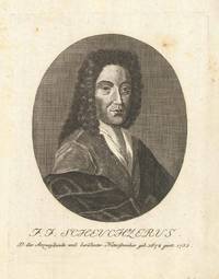
D. der Arzneykunde und beruhmter Naturforscher geb. 1672 gest. 1733.
by [ANONYMOUS]
- Used
- Condition
- Used
- Quantity Available
- 1
- Seller
-
London, United Kingdom
- Item Price
-
NZ$321.20NZ$32.12 shipping to USA
Show Details
Item Price
NZ$321.20
NZ$32.12
shipping to USA

De Cust van Westindien Punta St. Blaes: Panama
by ROGGEVEEN, Arent
- Used
- first
- Condition
- Used
- Quantity Available
- 1
- Seller
-
London, United Kingdom
- Item Price
-
NZ$5,353.25NZ$32.12 shipping to USA
Show Details
Description:
Amsterdam,, [c1680]. 430 by 535mm (17 by 21 inches).. Double-page engraved chart with fine hand-colour in part and in outline. First large-scale Dutch chart of the northern Panama coast and the San Blas Islands - published in Roggeveen's exceedingly rare sea pilot 'Het Brandende Veen'. Roggeveen, born in Delshaven, came to Middleburg, the seat of both the Dutch East and West India Companies, in 1658. He worked for both companies teaching the art of navigation and helped to maintain their collections of hydrographic manuscripts and charts, including Spanish portolans of the West Indies. In the mid-1660s, assisted by his access to these collections, Roggeveen embarked upon compiling a series of large-scale charts of the North American coastline, West Indies, and, later, West Africa. Many of his charts are based upon the earlier large-scale work of Hessel Gerritsz and Joan Vingboons, both cartographers for the Dutch East and West India Companies, but Roggeveen's work was the first to show the whole…
Read More Item Price
NZ$5,353.25
NZ$32.12
shipping to USA

De Cust van Westindien Punta d Naes: Panama
by ROGGEVEEN, Arent
- Used
- first
- Condition
- Used
- Quantity Available
- 1
- Seller
-
London, United Kingdom
- Item Price
-
NZ$5,353.25NZ$32.12 shipping to USA
Show Details
Description:
Amsterdam,, [c1680]. 430 by 535mm (17 by 21 inches).. Double-page engraved chart with added hand colour. First large-scale Dutch sea chart of the Panamanian Coastline, between Bahia St. Blaes and and Punta de Naes, centered on Nombre de Dios and Porta Bella - published in Roggeveen's exceedingly rare sea pilot 'Het Brandende Veen'. Roggeveen, born in Delshaven, came to Middleburg, the seat of both the Dutch East and West India Companies, in 1658. He worked for both companies teaching the art of navigation and helped to maintain their collections of hydrographic manuscripts and charts, including Spanish portolans of the West Indies. In the mid-1660s, assisted by his access to these collections, Roggeveen embarked upon compiling a series of large-scale charts of the North American coastline, West Indies, and, later, West Africa. Many of his charts are based upon the earlier large-scale work of Hessel Gerritsz and Joan Vingboons, both cartographers for the Dutch East and West India Companies, but…
Read More Item Price
NZ$5,353.25
NZ$32.12
shipping to USA

De Cust van Westindien Venecuela en St Martha: Columbia
by ROGGEVEEN, Arent
- Used
- first
- Condition
- Used
- Quantity Available
- 1
- Seller
-
London, United Kingdom
- Item Price
-
NZ$6,423.90NZ$32.12 shipping to USA
Show Details
Description:
Amsterdam,, [c1680]. 430 by 535mm (17 by 21 inches).. Double-page engraved chart with fine hand-colour in part and in outline. Detailed chart of Columbia's east coast - published in Roggeveen's exceedingly rare sea pilot 'Het Brandende Veen'. Roggeveen, born in Delshaven, came to Middleburg, the seat of both the Dutch East and West India Companies, in 1658. He worked for both companies teaching the art of navigation and helped to maintain their collections of hydrographic manuscripts and charts, including Spanish portolans of the West Indies. In the mid-1660s, assisted by his access to these collections, Roggeveen embarked upon compiling a series of large-scale charts of the North American coastline, West Indies, and, later, West Africa. Many of his charts are based upon the earlier large-scale work of Hessel Gerritsz and Joan Vingboons, both cartographers for the Dutch East and West India Companies, but Roggeveen's work was the first to show the whole coastline of North America and the Caribbean.…
Read More Item Price
NZ$6,423.90
NZ$32.12
shipping to USA

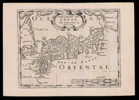
De Eilanden of het Keizerryk van Japan: Miniature map of Japan Volgens de Nieuwste Waarneminge opgesteld.
by HOLTROP, Willem
- Used
- Condition
- Used
- Quantity Available
- 1
- Seller
-
London, United Kingdom
- Item Price
-
NZ$428.26NZ$32.12 shipping to USA
Show Details
Description:
Te Amsterdam,: Holtrop,, [1776 or after].. 162 by 195mm. (6.5 by 7.75 inches).. Engraved map with original outline hand colour. The map first appeared in a miniature atlas by Steven van Esveldt. Holtrop married van Esveldt's daughter, and at some point after van Esveldt's death in 1776 the signature in the maps were changed to include Holtrop's name. Hubbard 111.2.
Item Price
NZ$428.26
NZ$32.12
shipping to USA
De Eilanden van Japan: Halma's Dutch edition of Sanson's map of Japan
by SANSON D'ABBEVILLE, Nicolas (I) and HALMA, Francois
- Used
- Condition
- Used
- Quantity Available
- 1
- Seller
-
London, United Kingdom
- Item Price
-
NZ$85.65NZ$32.12 shipping to USA
Show Details
Description:
[Amsterdam,: Francois Halma,, 1705].. 221 by 311mm. (8.75 by 12.25 inches).. Engraved map. Third state of the plate, first published in Halma's pirated edition of Sanson's 'L'Asie en plvsiers cartes nouvelles, et exactes;
', as part of 'L'Europe; L'Asie; L'Amerique
en Pluiers Cartes', 1683. A direct copy of Sanson's map of 1652, the only differences being the lack of a privilege and a date in the cartouche, the addition of the signature of the engraver, Antoine de Winter in the lower left corner. This issue was published in Halma's Dutch edition, 'Algemeene Wereldbeschryving
' in 1705 and is distinguished by the change of the title from French into Dutch. Francois Halma (1653-1722) set up his printing business in Utrecht in 1674, where he issued a number of pirated maps and atlases. In this instance, since Sanson was dead, Halma may have felt that there no harm and much profit to be gained from re-printing his work. The engraver, Antoine de Winter (c1652-1700) achieved some notoriety for…
Read More Item Price
NZ$85.65
NZ$32.12
shipping to USA

De Neuwe Platte: Pas: Caart Strekkende: Van: Cumbava tot Tiemoor Anno 1747: Manuscript VOC chart of the islands guarding the southern routes to the Spice Islands
by VEKE, Martinis van der
- Used
- Hardcover
- Signed
- Condition
- Used
- Binding
- Hardcover
- Quantity Available
- 1
- Seller
-
London, United Kingdom
- Item Price
-
NZ$53,532.50NZ$32.12 shipping to USA
Show Details
Description:
[Batavia],, 1747.. 985 by 680mm. (38.75 by 26.75 inches).. Manuscript chart, pen and black ink, and colour wash in outline, on two joined sheets of paper watermarked (lefthand sheet) with Strasburg Lily within a shield, initials "VDL" beneath and countermark "IV" (closest to Churchill 405, dated to 1733, from the mill of Pieter van der Ley, son of Gerrit Pieters van der Ley who worked De Wever - the Weaver - and De Bonsem - the Polecat - mills at Koog aan de Zaan, Holland, from 1674 onwards), and (righthand sheet) Strasburg Lily within a shield with crucifix "4" and "WR" beneath and countermark "IV" (closest to Churchill 406, dated to 1733, from the mill at Egmond in Holland), signed beneath the scale lower right. The Portuguese first settled on Timor in 1520, and the Spanish arrived in 1522. The Dutch took possession of the western portion of the island in 1613. Thereafter, until the twentieth century, the Dutch and the Portuguese struggled for supremacy of the island, with East Timor being…
Read More Item Price
NZ$53,532.50
NZ$32.12
shipping to USA

More Photos
De Zee-Atlas of Water-Waerelt,: The most up-to-date sea atlas of the second half of the seventeenth century Vertoonende all de Zee-Kusten Van het bekende Deel des Aerd-Bodems, Met een generale beschrijvinge van dien. Seer dienstigh vooralle Schippers en Stuurlieden; mitsgaders Koop-lied
by DONCKER, Hendrik
- Used
- Hardcover
- first
- Condition
- Used
- Binding
- Hardcover
- Quantity Available
- 1
- Seller
-
London, United Kingdom
- Item Price
-
NZ$171,304.00NZ$32.12 shipping to USA
Show Details
Description:
Amsterdam,: Hendrik Doncker, , 1666.. Folio atlas (500 by 320mm), title, preliminaries pages 14-22 text (complete), 34 double-page engraved charts, on laminated paper, fine original outline hand-colour, a list of previous owners of the atlas in manuscript to the upper paste-down, title-page margins skilfully repaired, some minor damp staining to margins, contemporary full calf, gilt fillet border, spine separated by raised bands, gilt. Although not the first to publish a sea atlas in Amsterdam that honour went to Janssonius the first edition of the 'Zee-Atlas' was published in 1659, and only one example of that edition is known, in the National Libary of Australia. Between then and 1669 the number of maps was extended from nineteen to fifty. In 1676 Doncker introduced the larger format 'De nieuwe groote vermeerderde Zeeatlas'. The atlas was re-issued until as late as the early 1700s when it was published by Doncker's son, also Hendrick, who continued the business following his father's death in…
Read More Item Price
NZ$171,304.00
NZ$32.12
shipping to USA

De Zeekusten van Westindien: This first large scale printed chart of Brazil and the Amazon
by ROGGEVEEN, Arent
- Used
- first
- Condition
- Used
- Quantity Available
- 1
- Seller
-
London, United Kingdom
- Item Price
-
NZ$5,353.25NZ$32.12 shipping to USA
Show Details
Description:
Amsterdam,, [c1680]. 430 by 535mm (17 by 21 inches).. Double-page engraved chart with fine hand-colour in part and in outline. Roggeveen's rare large scale chart of the Amazonian delta - published in Roggeveen's exceedingly rare sea pilot 'Het Brandende Veen'. This map shows the northern end of the Amazonian delta which empties out into the Atlantic to the lower leftmost corner, with the "Linea Aequinoetialis", or equator, clearly delineated. The coastal outline progresses into Brazil's northeastern coast in the Brazilian state of Amapa, whose River Oyapock (identified as "Rio Warypoco" in this map) marks the border between Brazil and French Guyana. Amapa was an historical administrative division of the former Portuguese colonial empires, who warded off English and Dutch invaders. Roggeveen, born in Delshaven, came to Middleburg, the seat of both the Dutch East and West India Companies, in 1658. He worked for both companies teaching the art of navigation and helped to maintain their collections of…
Read More Item Price
NZ$5,353.25
NZ$32.12
shipping to USA

De l'Acad.e Royale des Sciences Ne à Perinaldo dans la Comté de Nice, le 8 juin 1625 Mort à Paris, le 14 Septembre 1712.
by DUPUIS, N.; after BAUBRUN
- Used
- Condition
- Used
- Quantity Available
- 1
- Seller
-
London, United Kingdom
- Item Price
-
NZ$642.39NZ$32.12 shipping to USA
Show Details
Description:
[Paris,: À Paris du Odieuvre M.d. d'Estampes, quai de l'Ecole, vis-à-vis ka Samarit.e. à la belle Image CPR,, Eighteenth century].. 150 by 110mm (6 by 4.25 inches).. Prints,""Jean Dominique Cassini Jean Dominique Cassini Engraved portrait. Engraved by N. Dupuis, after painting by Baubrun, issue without imprint. Giovanni Domenico Cassini (1625-1712) an Italian mathematician and astronomer, who, on taking up French citizenship, changed his name to Jean-Dominique. He discovered four of the moons and the Cassini Division in the rings of Saturn in 1675. In cartography he was the first to make successful measurements of longitude by the method suggested by Galileo, using eclipses of the satellites of Jupiter as a clock, a method used to measure France accurately for the first time. On hearing that France was considerably smaller than expected, Louis XIV joked that Cassini had taken more of his kingdom from him than he had won in all his wars. Oxford History of Science Museum, 13626
Item Price
NZ$642.39
NZ$32.12
shipping to USA

More Photos
De uytnemende en seer vvonderlijcke zee-en-landt-reyse van de heer Ludovvyck di Barthema, van Bononien, Ridder &c. Gedaen inde Morgenlanden, Syrien, vrughtbaer en woest Arabien, Perssen, Indien, Egypten, Ethiopien en andere.: The first European to enter Mecca and Medina
by VARTHEMA, Ludvico di
- Used
- Hardcover
- Condition
- Used
- Binding
- Hardcover
- Quantity Available
- 1
- Seller
-
London, United Kingdom
- Item Price
-
NZ$42,826.00NZ$32.12 shipping to USA
Show Details
Description:
Utrecht,: Gerard Nieuwenhuysen & Willem Snellaert,, 1654.. 4to. Engraved frontispiece and 4 engraved plates, plates shaved, head of title-page reinforced, otherwise in good condition. Contemporary vellum. Collation: [8], 56, "56" [= 60], 24, [2, 2 blank] pp. Second Dutch translation of a highly important and adventurous narrative containing the first recorded visit of a non-Muslim to Mecca. Ludovico di Varthema or Barthema (ca. 1468-1517) sailed from Venice to Egypt in 1502 and travelled through Alexandria, Beirut, Tripoli, and Aleppo, arriving in Damascus in April 1503. Here he enrolled in the Mameluke garrison and proceeded overland to Khaybar, Medina and Mekka, thereby becoming the first European to enter the two holiest cities of Islam. His travels took him to South Arabia, Shiraz (Persia), India, Goa, Cochin, and supposedly the Malay isthmus, Sumatra, Banda, the Moluccas, the Spice Islands, Borneo, Java and Malacca. He finally returned to Lisbon in 1508. "Varthema's Itinerario, first…
Read More Item Price
NZ$42,826.00
NZ$32.12
shipping to USA

Dealer in Stourbridge Bricks, Fire Clay &c. Flatening. Tiles, Patent Stove. Liners, Class Pots &c. NB Engine for hire.
by FITCHETT, Jo[h]n
- Used
- Condition
- Used
- Quantity Available
- 1
- Seller
-
London, United Kingdom
- Item Price
-
NZ$428.26NZ$32.12 shipping to USA
Show Details
Description:
Birmingham,: 33, Potter Street,, [c1837-1849].. 60 by 90mm. (2.25 by 3.5 inches).. Prints,""J.No. Fitchett Casting Pot and Muffle, Manufacturer... M is for Muffle Maker Engraved trade card. Trade card of John Fitchett, who was listed as having appeared as """"the court for relief of insolvent debtors"""" in Warwick on March 28, 1833, but who appears to have later revivified his brick-making business. He is listed in both 'Pigot and co.'s national commercial directory' of 1837 and 'Birmingham: History and General Directory of the Borough of Birmingham' from 1849 as active at 33 Potter Street. The present trade card, which is illustrated with engravings of various industrial items and machinery, with a weathered tree and large ship in the background, advertises a number of products and services. Fitchett manufactured casting pots and muffles for making bricks; a muffle furnace is one operated with an externally heated chamber which radiates heat inwards, so that the material within has no direct…
Read More Item Price
NZ$428.26
NZ$32.12
shipping to USA

More Photos
Dell'arcano del mare, di D. Ruberto Dudleo duca di Nortumbria, e conte di VVarvich, libri sei : The first atlas on Mercator's Projection from the library of Imperial geographer Wolfgang Engelbert, Earl of Auersperg
by DUDLEY, Robert.
- Used
- Hardcover
- first
- Condition
- Used
- Binding
- Hardcover
- Quantity Available
- 1
- Seller
-
London, United Kingdom
- Item Price
-
NZ$2,569,560.00NZ$32.12 shipping to USA
Show Details
Description:
Florence,: Francesco Onofri,, 1646-1647.. 6 parts in 3 volumes. Folio. Complete with half-titles, vignette title-pages, and all exceptionally fine engraved maps, plates and original moveable parts: Volume I: (343 by 233mm), Part I: 56 pages, 30 plates, including 24 folding, and 20 with volvelles, [3] leaves of tables (ephemerides) Part II: 76, [2] pages, 12 plates, including 7 folding, and 5 with volvelles, 15 folding maps; Part III: [4], 1-48, [4], 49-55, 8 plates (5 folding), 4 engravings on half-page, the first after plates 2, the second after plates 4, the other two between pages 16 and 17 Part IV: 39, [3] pages, 18 plates, including 15 folding; Volume II: (478 by 343mm), Part V: 36, [2] pages, 98 plates 150 illustrations, 24 folding plates including 15 with volvelles, 67 plates with 100 illustrations only on the recto and 9 with volvelles, 7 plates with 25 illustrations on recto and verso; Volume III: (468 by 330mm), Part VI: [2], 60, [2] pages, 132 folding maps including 59 of Europe, 17…
Read More Item Price
NZ$2,569,560.00
NZ$32.12
shipping to USA

Denny's Indexed Map of the City and County of San Francisco.: Monumental wall map of San Francisco Showing Official Grades and Subdivisions, compiled from the latest Public and Private Data.
by DENNY, Edward
- Used
- Condition
- Used
- Quantity Available
- 1
- Seller
-
London, United Kingdom
- Item Price
-
NZ$32,119.50NZ$32.12 shipping to USA
Show Details
Description:
San Francisco,: Edward Denny & Co Map Publishers,, 1919.. 630 by 810mm. (24.75 by 32 inches).. Lithographed wall map, printed in blue, with early colour wash in full, dissected and laid down on linen A monumental and attractive map of San Francisco. After the devastating earthquake and fire of 1906, San Francisco underwent an intense period of reconstruction and development, led by Chief engineer Michael Maurice O'Shaughnessy (1864-1934), who modernised the infrastructure of the city, and is revered as one of the most important civil engineers in American history. The city is limited by its natural boundaries with the Pacific Ocean, and San Francisco Bay on three sides, and the border with San Mateo County to the south. In 1912, the then mayor of San Francisco, James Rolph, persuaded O'Shaughnessy to take the post of chief engineer for the city, a position which he held for the next twenty years. "The tasks he faced were challenging, the more so as he could have made much more money in the private…
Read More Item Price
NZ$32,119.50
NZ$32.12
shipping to USA
![[Derbyshire] Darbieshire](https://d3525k1ryd2155.cloudfront.net/h/785/909/1162909785.0.m.jpg)
[Derbyshire] Darbieshire: Speed's map of Derbyshire described 1610.
by SPEED, John
- Used
- Condition
- Used
- Quantity Available
- 1
- Seller
-
London, United Kingdom
- Item Price
-
NZ$1,927.17NZ$32.12 shipping to USA
Show Details
Description:
London,: Performed by John Speede, and are to be sold in popes head Alley by Iohn Sudbury and G. Humble,, [1627].. 380 by 510mm. (15 by 20 inches).. Engraved map with hand colouring. A beautifully coloured map of Derbyshire, with insets of the city of Derby and the springs at Buxton. John Speed (1552-1629) was the outstanding cartographer of his age. His 'Theatre of Great Britain' was the first atlas of the British Isles: Speed prepared the maps himself about two years before they were published. His maps and books dominated the seventeenth-century English market. The present map is taken from the 1627 English edition published by George Humble. Chubb XXV.
Item Price
NZ$1,927.17
NZ$32.12
shipping to USA
![[Derbyshire] Darbieshire described](https://d3525k1ryd2155.cloudfront.net/h/019/910/1162910019.0.m.jpg)
[Derbyshire] Darbieshire described: Rare Roger Rea edition of Speed's map of Derbyshire
by SPEED, John
- Used
- Condition
- Used
- Quantity Available
- 1
- Seller
-
London, United Kingdom
- Item Price
-
NZ$1,927.17NZ$32.12 shipping to USA
Show Details
Description:
[London],: to be sold by Roger Rea the Elder and younger at ye Golden Crosse in Cornhill against ye Exchange,, 1665.. 410 by 550mm. (16.25 by 21.75 inches).. Hand-coloured double-page engraved map, upper left and right margins skilfully repaired, margins reinforced with japanned paper. The map bears the imprint of Roger Rea the Elder and Younger. The Reas had purchased the rights to Speed's work form William Garrett in 1659, who had previously purchased them from the widow of William Humble in the same year. Skelton suggests that the father and son intended a new edition of the atlas for the Restoration, of 1660. However, the atlas would appear not to have been published until 1665. This is borne out by an advertisement in the Term Catalogue by the subsequent owners of the plates, Thomas Bassett and Richard Chiswell, in 1675: "Mr John Speed's... Geography of the Kingdoms of England, Scotland, and Ireland... together with his Prospect... all in one entire Volume, hath been, for seven Years past, out…
Read More Item Price
NZ$1,927.17
NZ$32.12
shipping to USA

Des Academies Royales des Belles-Lettres, & des Sciences. Sur La Chine. [WITH:] Considérations générales, sur l'étude et les connaissances que demande la composition des ouvrages de géographie.
by D'ANVILLE, [Jean Baptiste Bourguignon]
- Used
- first
- Condition
- Used
- Quantity Available
- 1
- Seller
-
London, United Kingdom
- Item Price
-
NZ$9,635.85NZ$32.12 shipping to USA
Show Details
Description:
A Pe-Kin, et se trouvé a Paris,: for the Author; Lambert,, 1776 and 1777.. 205 by 120mm. (8 by 4.75 inches).. Books,""Memoire de M. D'Anville, Premier Geographe du Roi, D'Anville's maps of China Octavo (205 by 120mm), two works bound in one volume, title, [2]-47pp, light spotting [AND] title, [2]-111pp., light spotting, marbled edges, pink silk marker, contemporary polished calf gilt, spine with three black morocco labels, lettered in gilt. Collation: A-C8; A-G8. First editions of two works by the great French cartographer d'Anville, who was engaged by the Jesuits to produce three maps based on the findings of the Jesuit missionaries to China, for inclusion in Pierre Du Halde's 'Description géographique... de l'Empire de la Chine et de la Tartarie Chinoise' (1735). These were subsequently revised for the 'Nouvel atlas de la Chine' (1737). In the 'Mémoire' he provided a comprehensive explanation for his methodology in preparing the maps, the sources he had chosen to draw from and an overview of…
Read More Item Price
NZ$9,635.85
NZ$32.12
shipping to USA
More Photos
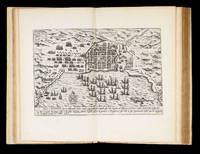
Description des Indes Occidentales, qu'on appelle aujourdhuy le Nouveau Monde: The first town plan of anywhere in the present-day United States" Par Antoine de Herrera, avec la Navigation du Vaillant Capitaine de Mer Jacques le Maire, & de plusieurs autres...
by HERRERA [Y TORDESILLAS], A de, [JACOB Le Maire, Willem CORNELIS SCHOUTEN, Giovanni Battista BOAZIO], et al.
- Used
- Hardcover
- first
- Condition
- Used
- Binding
- Hardcover
- Quantity Available
- 1
- Seller
-
London, United Kingdom
- Item Price
-
NZ$546,031.50NZ$32.12 shipping to USA
Show Details
Description:
Amsterdam,: Chez Emanuel Colin de Thovoyon,, 1622.. Folio (310 by 200mm), first French edition second issue (title page canncelled, with Paris imprint added to that of Amsterdam) engraved title with vignettes and map, [8], 103, [1, blank], [6], 107-254 pp., head- and tail-pieces, with decorated initials; 27 engraved plates, pictorial title page, 17 maps and charts (16 double-page, 1 folded), 4 city views, 5 text engravings (scenes from Le Maire voyage), portrait of Le Maire not present as usual for the French edition, seventeenth century vellum. The first French edition of Herrera'a rare work here extra-illustrated with Boazio's exceedingly rare views of Santo Domingo (Dominican Republic); Santiago (Cape Verde Islands); Cartagena (Columbia); and San Augustine (Florida) - first known engraving of any locality in the present-day United States. The importance of this French edition of Herrera's 'Description des Indes Occidentales', and the other 1622 editions in Latin and Dutch, lies in its engraved…
Read More Item Price
NZ$546,031.50
NZ$32.12
shipping to USA

More Photos
Description Geographique des Isles Antilles possedees par les Anglois.: Louis XV's intentions in the Caribbean
by BELLIN, Jacques Nicolas
- Used
- Hardcover
- Condition
- Used
- Binding
- Hardcover
- Quantity Available
- 1
- Seller
-
London, United Kingdom
- Item Price
-
NZ$12,847.80NZ$32.12 shipping to USA
Show Details
Description:
Paris,: De L'Imprimerie de Didot,, 1758.. 250 by 190mm. (9.75 by 7.5 inches).. Quarto, additional engraved title-page by P.P. Choffard, laid down, 7 double-page and folding and 4 full-page charts, one folding plan, one full-page plan, 10 vignette headpieces including 7 views by Choffard; contemporary mottled calf, gilt supra-libros of Louis XV of France, and the "Marine Intendant ou Port de Brest" on each cover, preserved in morocoo backed cloth slipcase and chemise. Collation: [-](2), a, b(4), A-X(4), Y(2); xii, 171 A very attractive atlas of the West Indies, focused on the valuable British possessions, which were of great interest to the French and their ally Spain, during the Seven Years' War. The atlas is brimming with information useful to the embattled French Navy, and it is not surprising that this example should have been in the library of the port authority at Brest a major port for French ships operating in the Atlantic. Since several other examples are known with the arms of Louis XV,…
Read More Item Price
NZ$12,847.80
NZ$32.12
shipping to USA

Descriptive Map of East End Poverty,: Charles Booth's rare poverty map of London's East End Compiled from School Board reports in 1887.
by BOOTH, Charles
- Used
- Condition
- Used
- Quantity Available
- 1
- Seller
-
London, United Kingdom
- Item Price
-
NZ$9,635.85NZ$32.12 shipping to USA
Show Details
Description:
London,: McMillian & Co.,, 1889.. 365 by 490mm. (14.25 by 19.25 inches).. Lithograph plan, printed in colours, dissected and mounted on linen. The first of Charles Booth's famous poverty maps of London to be published, in his seminal work 'Labour and Life of the People, Volume 1: East London'. The areas it covers include Hoxton, Bethnal Green, Whitechapel, Mile End Road and Limehouse. When the full survey was published in 1891 this map was dropped for one matching the other three in the set. However this early map has the same features, with the streets colour-coded according to the degree of wealth of the inhabitants, ranging from black ('Very poor, lowest class... Vicious, semi-criminal'), through shades of blue and purple ('Poor', 'Mixed', 'Fairly Comfortable'), to red ('Well to do'). Booth's highest class, yellow ('Wealthy'), does not appear on this map. Booth (1840-1916), owner of the Booth Shipping Line, acted in response to an 1886 Pall Mall Gazette article that claimed that 25% of Londoners…
Read More Item Price
NZ$9,635.85
NZ$32.12
shipping to USA

Didn’t find what you’re looking for?
Try adding this search to your want list. Millions of books are added to our site everyday and when we find one that matches your search, we’ll send you an email. Best of all, it’s free.
Add to Want List

Are you a frequent reader or book collector?
Join the Bibliophile's Club and save 10% on every purchase, every day — up to $20 savings per order!

Social Responsibility
Did you know that since 2004, Biblio has used its profits to build 16 public libraries in rural villages of South America?
