Description:
Boxing ticket, 2 1/2" x 5 3/4,"printed on green stiff paper. Some very slight aging, but it really nice condition overall. This is an exchange ticket that allows the holder to exchange it for This is a complimentary exchange ticket that allows the holder to exchange it for a $16.50 fight ticket for $4.00 in taxes at the Morrison Hotel (Room 340). This would be the "Cinderella Man's" last title fight. He put up a valiant fight, and even dropped Louis early on, but would end up getting knocked out in the eight round. Braddock would have a great early career, but injuries, and a string of loses almost took him out of the fight game, until he made a remarkable comeback that won him the heavyweight championship from Max Baer. Unfortunately, Louis put an end to that in the next fight.
Search Results: Titles starting with J from Nicholas D. Riccio Rare Books & Prints
You searched for:
- Bookseller inventory: Nicholas D. Riccio Rare Books & Prints (titles starting with J)
- Bookseller: Nicholas D. Riccio Rare Books & Prints
Results 1 - 20 of 37

Jim Braddock vs. Joe Louis (15 Rounds) Comiskey Park. Complimentary Exchange Ticket June 22nd 1937.
by [Boxing Ticket]
- Used
- Condition
- Used
- Quantity Available
- 1
- Seller
-
Florham Park, New Jersey, United States
- Item Price
-
NZ$256.80NZ$13.70 shipping to USA
Show Details
Item Price
NZ$256.80
NZ$13.70
shipping to USA

Joe Louis: My Life.
by Louis, Joe.
- Used
- Condition
- Used
- Quantity Available
- 1
- Seller
-
Florham Park, New Jersey, United States
- Item Price
-
NZ$42.80NZ$13.70 shipping to USA
Show Details
Description:
8vo, cloth, gilt totle on spine, illustrated, 277 pp. Slight edge and spine wear to dust jacket; otherwise in excellent condition.Joe Louis often regarded as one of the best heavyweight champions ever, held the title for 12 years. He had some great fights against Billy Conn, James Braddock, Max Bear, Tony Galento and Max Schmeling. His second fight with Max Schmeling, because of the political landscape of that time, was considered one of the most important sporting events of the 20th century.
Item Price
NZ$42.80
NZ$13.70
shipping to USA
Johnson of the Mohawks
by Pound, Arthur
- Used
- Hardcover
- Condition
- Used
- Binding
- Hardcover
- Quantity Available
- 1
- Seller
-
Florham Park, New Jersey, United States
- Item Price
-
NZ$171.20NZ$13.70 shipping to USA
Show Details
Description:
Small 4to red cloth illustrated 536pp. A very nice copy. William Johnson who was born around 1715, and came to America when he was 23 in 1738. Johnson made a name for himself in the colonial frontier, and developed important and lasting relationships with the Mohawks and Iroquois. He was the hero of the battle of Lake George during the French and Indian War, and was knighted for his exploits during the campaigns of that war. Perhaps his real claim to fame was the critical relationships he established with important Indian tribes and his role in keeping those tribes loyal to the British. He died in 1774.
Item Price
NZ$171.20
NZ$13.70
shipping to USA
Johnson's Map of Arkansas, Mississippi, and Louisiana
by Johnson, A.J
- Used
- Condition
- Used
- Quantity Available
- 1
- Seller
-
Florham Park, New Jersey, United States
- Item Price
-
NZ$171.20NZ$13.70 shipping to USA
Show Details
Description:
New York: A.J. Johnson, 1867. Unbound, colored engraved map, decorative boarder, double page, 25" x 17". Some toning and aging; otherwise fairly bright and clean and in very nice condition. Alvin Jewett Johnson (1827-1884) appears to have entered the map publishing business in 1860. It appears that he obtained J.H. Colton's map copyrights, and published the first installment of the Johnson's New Illustrated (Steel Plate) Family Atlas In that year. Many of the maps Johnson would use would bear the J.H. Colton copyright for many years. Johnson's Atlas would run from 1860 to 1885. While Johnson would use somewhat similar boarder designs, map coloring would appear a little heavier than the earlier Colton maps. This map of Arkansas, Mississippi, and Louisiana is from the 1867 edition of Johnson's Illustrated Family Atlas. Very nice coloring and good county level detail. Ristow 325-326
Item Price
NZ$171.20
NZ$13.70
shipping to USA
Johnson's Map of Ohio
by Johnson, A.J
- Used
- Condition
- Used
- Quantity Available
- 1
- Seller
-
Florham Park, New Jersey, United States
- Item Price
-
NZ$145.52NZ$13.70 shipping to USA
Show Details
Description:
New York: A.J. Johnson, 1867. Unbound, colored engraved map, decorative boarder, double page 25" x17". Some toning and aging, a small tape repair at center fold, small nick at bottom edge; otherwise very good, and bright and clean. Alvin Jewett Johnson (1827-1884) appears to have entered the map publishing business in 1860. It appears that he obtained J.H. Colton's map copyrights, and published the first installment of the Johnson's New Illustrated (Steel Plate) Family Atlas In that year. Many of the maps Johnson would use would bear the J.H. Colton copyright for many years. Johnson's Atlas would run from 1860 to 1885. While Johnson would use somewhat similar boarder designs, map coloring would appear a little heavier than the earlier Colton maps. This double page map of Ohio is from the 1867 edition of Johnson's Illustrated Family Atlas. Coloring is nice, good county level detail, and a small engraving of the state capital is included on the map. Ristow 325-326
Item Price
NZ$145.52
NZ$13.70
shipping to USA

Johnson's Map of Asia
by Johnson, A.J
- Used
- Condition
- Used
- Quantity Available
- 1
- Seller
-
Florham Park, New Jersey, United States
- Item Price
-
NZ$128.40NZ$13.70 shipping to USA
Show Details
Description:
New York: A.J. Johnson, 1867. Unbound, colored engraved map, decorative boarder, 16" x13". Some toning and aging, a couple of chips at the edge of a very ample margin; otherwise fairly bright and clean and in very nice condition. Alvin Jewett Johnson (1827-1884) appears to have entered the map publishing business in 1860. It appears that he obtained J.H. Colton's map copyrights, and published the first installment of the Johnson's New Illustrated (Steel Plate) Family Atlas In that year. Many of the maps Johnson would use would bear the J.H. Colton copyright for many years. Johnson's Atlas would run from 1860 to 1885. While Johnson would use somewhat similar boarder designs, map coloring would appear a little heavier than the earlier Colton maps. This map of Asia is from the 1867 edition of Johnson's Illustrated Family Atlas, and has nice coloring and good detail. The 19th century political geography makes this map interesting from that standpoint. May require extra postage.Ristow 325-326
Item Price
NZ$128.40
NZ$13.70
shipping to USA

Johnson's Map of Russia
by Johnson, A.J
- Used
- Condition
- Used
- Quantity Available
- 1
- Seller
-
Florham Park, New Jersey, United States
- Item Price
-
NZ$145.52NZ$13.70 shipping to USA
Show Details
Description:
New York: A.J. Johnson, 1867. Unbound, colored engraved map, decorative boarder, 16" x13". Slight toning and aging, a few of chips at the edge of a very ample margin; otherwise bright and clean and in very nice condition. Alvin Jewett Johnson (1827-1884) appears to have entered the map publishing business in 1860. It appears that he obtained J.H. Colton's map copyrights, and published the first installment of the Johnson's New Illustrated (Steel Plate) Family Atlas In that year. Many of the maps Johnson would use would bear the J.H. Colton copyright for many years. Johnson's Atlas would run from 1860 to 1885. While Johnson would use somewhat similar boarder designs, map coloring would appear a little heavier than the earlier Colton maps. This map of Russia is from the 1867 edition of Johnson's Illustrated Family Atlas, and has nice coloring and substantial detail. Ristow 325-326
Item Price
NZ$145.52
NZ$13.70
shipping to USA
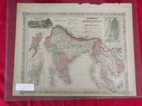
Johnson's Map of Hindostan and British India
by Johnson, A.J
- Used
- Condition
- Used
- Quantity Available
- 1
- Seller
-
Florham Park, New Jersey, United States
- Item Price
-
NZ$128.40NZ$13.70 shipping to USA
Show Details
Description:
New York: A.J. Johnson, 1867. Unbound, colored engraved map, decorative boarder, 17" x 14". Some browning and aging; a couple of chips at the edge of a very ample margin, bottom margin somewhat narrow; otherwise fairly bright and clean and in very nice condition. Alvin Jewett Johnson (1827-1884) appears to have entered the map publishing business in 1860. It appears that he obtained J.H. Colton's map copyrights, and published the first installment of the Johnson's New Illustrated (Steel Plate) Family Atlas In that year. Many of the maps Johnson would use would bear the J.H. Colton copyright for many years. Johnson's Atlas would run from 1860 to 1885. While Johnson would use somewhat similar boarder designs, map coloring would appear a little heavier than the earlier Colton maps. This map of Hindostan, or India, is from the 1867 edition of Johnson's Illustrated Family Atlas, and has nice coloring and substantial detail. May require extra postage. Ristow 325-326
Item Price
NZ$128.40
NZ$13.70
shipping to USA
Johnsons New Illustrated Family Atlas of the World
by Johnson, A.J
- Used
- Hardcover
- Condition
- Used
- Binding
- Hardcover
- Quantity Available
- 1
- Seller
-
Florham Park, New Jersey, United States
- Item Price
-
NZ$2,996.00NZ$13.70 shipping to USA
Show Details
Description:
Large folio, binding original leather spine with tips and cloth, with gold lettering, illustrated with maps in color. Some minor wear to edges, dampstaining through much of the book, but not materially affecting the map images, front endpaper folded; otherwise very good. This atlas includes a natural history section showing illustrations of some exotic animals. It also contains over 30 maps of U.S. subjects, and a good number of double page maps.
Item Price
NZ$2,996.00
NZ$13.70
shipping to USA
Johnson's Map of Switzerland
by Johnson, A.J
- Used
- Condition
- Used
- Quantity Available
- 1
- Seller
-
Florham Park, New Jersey, United States
- Item Price
-
NZ$145.52NZ$13.70 shipping to USA
Show Details
Description:
New York: A.J. Johnson, 1867. Unbound, colored engraved map, decorative boarder, 16" x 13". Some toning, browning, and aging; still fairly bright and clean and in very nice condition. Alvin Jewett Johnson (1827-1884) appears to have entered the map publishing business in 1860. It appears that he obtained J.H. Colton's map copyrights, and published the first installment of the Johnson's New Illustrated (Steel Plate) Family Atlas In that year. Many of the maps Johnson would use would bear the J.H. Colton copyright for many years. Johnson's Atlas would run from 1860 to 1885. While Johnson would use somewhat similar boarder designs, map coloring would sometimes appear a little heavier than the earlier Colton maps. This is a nice single page map of Switzerland from the 1867 edition of Johnson's Illustrated Family Atlas. The map layout is very good, with considerable detail of the country. Ristow 325-326
Item Price
NZ$145.52
NZ$13.70
shipping to USA
Johnson's Map of Georgetown and Washington
by Johnson, A.J
- Used
- Condition
- Used
- Quantity Available
- 1
- Seller
-
Florham Park, New Jersey, United States
- Item Price
-
NZ$128.40NZ$13.70 shipping to USA
Show Details
Description:
New York: A.J. Johnson, 1867. Unbound, colored engraved map, decorative boarder, 16" x13". Some toning and aging; otherwise bright and clean and in very nice condition. Alvin Jewett Johnson (1827-1884) appears to have entered the map publishing business in 1860. It appears that he obtained J.H. Colton's map copyrights, and published the first installment of the Johnson's New Illustrated (Steel Plate) Family Atlas In that year. Many of the maps Johnson would use would bear the J.H. Colton copyright for many years. Johnson's Atlas would run from 1860 to 1885. While Johnson would use somewhat similar boarder designs, map coloring would appear a little heavier than the earlier Colton maps. This map of Washington DC is from the 1867 edition of Johnson's Illustrated Family Atlas. The map has nice coloring, and engravings of the Capital Building, the Washington Monument, and the Smithsonian. Ristow 325-326
Item Price
NZ$128.40
NZ$13.70
shipping to USA
Johnson's Map of China and Japan
by Johnson, A.J
- Used
- Condition
- Used
- Quantity Available
- 1
- Seller
-
Florham Park, New Jersey, United States
- Item Price
-
NZ$171.20NZ$13.70 shipping to USA
Show Details
Description:
New York: A.J. Johnson, 1870. Unbound, colored engraved map, decorative boarder, double page, 24" x17". Slight toning and aging; otherwise bright and clean and in very nice condition. Alvin Jewett Johnson (1827-1884) appears to have entered the map publishing business in 1860. It appears that he obtained J.H. Colton's map copyrights, and published the first installment of the Johnson's New Illustrated (Steel Plate) Family Atlas In that year. Many of the maps Johnson would use would bear the J.H. Colton copyright for many years. Johnson's Atlas would run from 1860 to 1885. While Johnson would use somewhat similar boarder designs, map coloring would appear a little heavier than the earlier Colton maps. This double page map of China and Japan is from the 1870 edition of Johnson's Illustrated Family Atlas. The color is nice, and there is substantial detail on China. Also includes a small inset map of Canton and Hong Kong. Ristow 325-326
Item Price
NZ$171.20
NZ$13.70
shipping to USA

Johnson's Map of China
by Johnson, A.J
- Used
- Condition
- Used
- Quantity Available
- 1
- Seller
-
Florham Park, New Jersey, United States
- Item Price
-
NZ$214.00NZ$13.70 shipping to USA
Show Details
Description:
New York: A.J. Johnson, 1867. Unbound, colored engraved map, decorative boarder, 16" x13". Slight toning and aging, a couple of chips at the edge of a very ample margin; otherwise bright and clean and in very nice condition. Alvin Jewett Johnson (1827-1884) appears to have entered the map publishing business in 1860. It appears that he obtained J.H. Colton's map copyrights, and published the first installment of the Johnson's New Illustrated (Steel Plate) Family Atlas In that year. Many of the maps Johnson would use would bear the J.H. Colton copyright for many years. Johnson's Atlas would run from 1860 to 1885. While Johnson would use somewhat similar boarder designs, map coloring would appear a little heavier than the earlier Colton maps. This map of China is from the 1867 edition of Johnson's Illustrated Family Atlas, and has nice coloring and substantial detail. The J.H. Colton 1855 copyright still appears on this map. May require extra postage. Ristow 325-326
Item Price
NZ$214.00
NZ$13.70
shipping to USA
Johnson's Map of Africa
by Johnson, A.J
- Used
- Condition
- Used
- Quantity Available
- 1
- Seller
-
Florham Park, New Jersey, United States
- Item Price
-
NZ$171.20NZ$13.70 shipping to USA
Show Details
Description:
New York: A.J. Johnson, 1867. Unbound, colored engraved map, decorative boarder, double page, 24" x17 1/2". Some toning and aging, a couple of chips or slight folds at the edges, small tear in margin of center fold; otherwise fairly bright and clean and in very nice condition. Alvin Jewett Johnson (1827-1884) appears to have entered the map publishing business in 1860. It appears that he obtained J.H. Colton's map copyrights, and published the first installment of the Johnson's New Illustrated (Steel Plate) Family Atlas In that year. Many of the maps Johnson would use would bear the J.H. Colton copyright for many years. Johnson's Atlas would run from 1860 to 1885. While Johnson would use somewhat similar boarder designs, map coloring would appear a little heavier than the earlier Colton maps. This map of Africa is from the 1867 edition of Johnson's Illustrated Family Atlas, and has nice coloring and good detail. The map includes smaller inset maps of The Nile, Liberia, and Cape Colony. Ristow 325-326
Item Price
NZ$171.20
NZ$13.70
shipping to USA
More Photos
Johnson's Dictionary of the English Language in Miniature… Third American Edition
by Johnson, Samuel
- Used
- Condition
- Used
- Edition
- Third American Edition
- Quantity Available
- 1
- Seller
-
Florham Park, New Jersey, United States
- Item Price
-
NZ$599.20NZ$13.70 shipping to USA
Show Details
Description:
12mo, contemporary tree calf, portrait frontispiece, 276 pp. Minor wear, offsetting on to title, some aging & foxing. Early 'pocket' Johnson dictionary, definitions are very concise, but its an excellent sample of a dictionary from that period. It is also in very nice condition.
Item Price
NZ$599.20
NZ$13.70
shipping to USA
Johnson's Map of Florida
by Johnson, A.J
- Used
- Condition
- Used
- Quantity Available
- 1
- Seller
-
Florham Park, New Jersey, United States
- Item Price
-
NZ$171.20NZ$13.70 shipping to USA
Show Details
Description:
New York: A.J. Johnson, 1867. Unbound, colored engraved map, decorative boarder, 16" x13". Some toning, browing, and aging; otherwise fairly bright and clean and in very good condition. Alvin Jewett Johnson (1827-1884) appears to have entered the map publishing business in 1860. It appears that he obtained J.H. Colton's map copyrights, and published the first installment of the Johnson's New Illustrated (Steel Plate) Family Atlas In that year. Many of the maps Johnson would use would bear the J.H. Colton copyright for many years. Johnson's Atlas would run from 1860 to 1885. While Johnson would use somewhat similar boarder designs, map coloring would sometimes appear a little heavier than the earlier Colton maps. This map of Florida is from the 1867 edition of Johnson's Illustrated Family Atlas, and has good coloring and substantial detail. Like the Colton map of Florida, this map includes a small inset map of the Florida Keys. Ristow 325-326
Item Price
NZ$171.20
NZ$13.70
shipping to USA
Johnson's Map of Kentucky and Tennessee
by Johnson, A.J
- Used
- Condition
- Used
- Quantity Available
- 1
- Seller
-
Florham Park, New Jersey, United States
- Item Price
-
NZ$128.40NZ$13.70 shipping to USA
Show Details
Description:
New York: A.J. Johnson, 1867. Unbound, colored engraved map, decorative boarder, 25" x 17". Some toning and aging otherwise fairly bright and clean and in very nice condition. Alvin Jewett Johnson (1827-1884) appears to have entered the map publishing business in 1860. It appears that he obtained J.H. Colton's map copyrights, and published the first installment of the Johnson's New Illustrated (Steel Plate) Family Atlas In that year. Many of the maps Johnson would use would bear the J.H. Colton copyright for many years. Johnson's Atlas would run from 1860 to 1885. While Johnson would use somewhat similar boarder designs, map coloring would appear a little heavier than the earlier Colton maps. This map of Kentucky and Tennessee is from the 1867 edition of Johnson's Illustrated Family Atlas. The map has nice coloring, good county detail, and two engraved illustrations. Ristow 325-326
Item Price
NZ$128.40
NZ$13.70
shipping to USA
Johnson's Map of Mexico
by Johnson, A.J
- Used
- Condition
- Used
- Quantity Available
- 1
- Seller
-
Florham Park, New Jersey, United States
- Item Price
-
NZ$171.20NZ$13.70 shipping to USA
Show Details
Description:
New York: A.J. Johnson, 1867. Unbound, colored engraved map, decorative boarder, 16" x 13". Some toning and aging, bottom margin somewhat narrow, with small chip; otherwise very good, and generally bright and clean. Alvin Jewett Johnson (1827-1884) appears to have entered the map publishing business in 1860. It appears that he obtained J.H. Colton's map copyrights, and published the first installment of the Johnson's New Illustrated (Steel Plate) Family Atlas In that year. Many of the maps Johnson would use would bear the J.H. Colton copyright for many years. Johnson's Atlas would run from 1860 to 1885. While Johnson would use somewhat similar boarder designs, map coloring would sometimes appear a little heavier than the earlier Colton maps. This single page map of Mexico is from the 1867 edition of Johnson's Illustrated Family Atlas. Coloring is nice, it has a good level of detail. Also includes a small inset map of Tehuartepec. Ristow 325-326
Item Price
NZ$171.20
NZ$13.70
shipping to USA
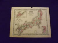
Johnson's Map of Japan.
by Johnson, A.J.
- Used
- Condition
- Used
- Quantity Available
- 1
- Seller
-
Florham Park, New Jersey, United States
- Item Price
-
NZ$145.52NZ$13.70 shipping to USA
Show Details
Description:
Unbound, colored engraved map, decorative boarder, double page, 17" x14". Slight toning and aging, a couple of chips and tears along the top edge, but margins are fairly wide; otherwise bright and clean and in very nice condition. Alvin Jewett Johnson (1827-1884) appears to have entered the map publishing business in 1860. It appears that he obtained J.H. Colton's map copyrights, and published the first installment of the Johnson's New Illustrated (Steel Plate) Family Atlas In that year. Many of the maps Johnson would use would bear the J.H. Colton copyright for many years. Johnson's Atlas would run from 1860 to 1885. While Johnson would use somewhat similar boarder designs, map coloring would appear a little heavier than the earlier Colton maps. This double page map of Japan is from the 1867 edition of Johnson's Illustrated Family Atlas. The color is nice, and there is substantial detail, and includes a small inset of Nagasaki. The map retains the 1855 J.H, Colton copyright. May require extra…
Read More Item Price
NZ$145.52
NZ$13.70
shipping to USA
Johnson's Map of Australia
by Johnson, A.J
- Used
- Condition
- Used
- Quantity Available
- 1
- Seller
-
Florham Park, New Jersey, United States
- Item Price
-
NZ$145.52NZ$13.70 shipping to USA
Show Details
Description:
New York: A.J. Johnson, 1867. Unbound, colored engraved map, decorative boarder, 16" x13". Some toning, browning, and aging; otherwise fairly bright and clean and in very good condition. Alvin Jewett Johnson (1827-1884) appears to have entered the map publishing business in 1860. It appears that he obtained J.H. Colton's map copyrights, and published the first installment of the Johnson's New Illustrated (Steel Plate) Family Atlas In that year. Many of the maps Johnson would use would bear the J.H. Colton copyright for many years. Johnson's Atlas would run from 1860 to 1885. While Johnson would use somewhat similar boarder designs, map coloring would sometimes appear a little heavier than the earlier Colton maps. This map of Australia is from the 1867 edition of Johnson's Illustrated Family Atlas, and has nice coloring. While the map doesn't provide great detail, Australia is kind of the wide open spaces at that time. However, the map does provide a list of counties for the different parts of the…
Read More Item Price
NZ$145.52
NZ$13.70
shipping to USA

Didn’t find what you’re looking for?
Try adding this search to your want list. Millions of books are added to our site everyday and when we find one that matches your search, we’ll send you an email. Best of all, it’s free.
Add to Want List

Are you a frequent reader or book collector?
Join the Bibliophile's Club and save 10% on every purchase, every day — up to $20 savings per order!

Social Responsibility
Did you know that since 2004, Biblio has used its profits to build 16 public libraries in rural villages of South America?
