Description:
Islington,: Near the Thatch'd House, Lower Street,, [c1798-1800].. 115 by 75mm (4.5 by 3 inches).. Maps,""Benj. Baker Engraver... Trade card with a miniature map of Georgian Islington Engraved trade card. Benjamin Baker's (1766-1841) trade card includes a detailed miniature map of Islington, where he had premises from at least 1791-1800. A key to the upper right lists schools, religious houses, alms houses, and a turnpike road. Baker became a prolific producer of engraved maps from the late eighteenth century onwards, including for William Faden. As a map engraver and publisher, he resided first at 32 High Street, Islington from 1791-1793 and then in Lower Street, Islington from 1798-1800. In 1804, he became principal engraver to the Ordnance Survey and he and his firm were regarded as """"the best topographical engravers in Europe"""" (Seymour). There he worked with his three sons: Benjamin Richard (1792-1876), one of the initial surveyors who did the Survey of Ireland from 18241845; Alfred…
Read More Search Results: Titles starting with N from Daniel Crouch Rare Books Ltd
You searched for:
- Bookseller inventory: Daniel Crouch Rare Books Ltd (titles starting with N)
- Bookseller: Daniel Crouch Rare Books Ltd
Results 1 - 20 of 59

N.B. Maps, Charts, & c. Accurately Engrav'd.
by BAKER, Benjamin
- Used
- Condition
- Used
- Quantity Available
- 1
- Seller
-
London, United Kingdom
- Item Price
-
NZ$4,282.60NZ$32.12 shipping to USA
Show Details
Item Price
NZ$4,282.60
NZ$32.12
shipping to USA

NB. All sorts of Instruments carefully Ground and Set.
by PEPYS, Richard; and James LARKEN
- Used
- Signed
- Condition
- Used
- Quantity Available
- 1
- Seller
-
London, United Kingdom
- Item Price
-
NZ$2,034.24NZ$32.12 shipping to USA
Show Details
Description:
London,: at the Crown and Scepter, in Bishopsgate Street, near the South Sea House,, [c1761].. 135 by 205mm. (5.25 by 8 inches).. Prints,""Bought of Richard Pepys Surgeons Instrument Maker and Cutler... Cook's first cartographer Engraved letterhead. Signed receipt for """"12 Best Rasors"""" to Mr. Hollis, and dated March 10th 176[?]. The letterhead was engraved for Pepys by James Larken (1732-1774), who was responsible for a number of trade cards and letterheads of the period (see BM Heal collection) but is now best remembered as the engraver of two of the earliest charts by Captain James Cook, accompanied by his sailing directions, and has his expense: 'A Chart of the Straights of Bellisle with part of the coast of Newfoundland and Labradore from actual surveys Taken by Order of Commodore Palliser Governor of Newfoundland, Labradore, &c by James Cook Surveyor 1766'; and 'A Chart, of Part of the South Coast, of Newfoundland, including the Islands of St. Peters and Miquelon, from an actual survery…
Read More Item Price
NZ$2,034.24
NZ$32.12
shipping to USA

NB. Blinds Painted and Repaired.
by BARRON, [James] & MILLS
- Used
- Condition
- Used
- Quantity Available
- 1
- Seller
-
London, United Kingdom
- Item Price
-
NZ$428.26NZ$32.12 shipping to USA
Show Details
Description:
London,: 72 Wells Street, Oxford Street,, [c1834-1839].. 60 by 90mm. (2.25 by 3.5 inches).. Prints,""Barron & Mills, Patent Blind Manufacturers... V is for Venetian Blind Maker Engraved trade card. James Barron first appears in the records in Holden's 'Triennial Directory' for the years 1805 to 1807, where he is listed as a Venetian blind maker active at Edgbaston Street, Birmingham. In 1820, Barron, who then occupied 73 Wells Street, London and 11 Lower Temple Street, Birmingham published a pamphlet addressed """"to cabinet-makers and upholsterers in general"""" and entitled """"Modern and Elegant Designs of Cabinet & Upholstery Furniture"""". The bulk of the work was taken up with charming illustrations of various pieces of furniture, and also included a explanation of """"Barron's Patent Roller Blinds"""", a list of materials used and stocked by Barron at his shops, as well as a price list. 'The London Upholsterer's Companion' of 1834 lists Barron and Mills of both 72 and 73 Wells Street as…
Read More Item Price
NZ$428.26
NZ$32.12
shipping to USA

NB Who has the Honour to Serve te Royal Family
by HOGARTH, William; and Richard HAND
- Used
- Condition
- Used
- Quantity Available
- 1
- Seller
-
London, United Kingdom
- Item Price
-
NZ$5,353.25NZ$32.12 shipping to USA
Show Details
Description:
[London],: at the Kings Arms, at Chelsey Remov'd from ye Old Original Celsey Bunn-house, 1718.. (sheet) 220 by 160mm. (8.75 by 6.25 inches); (plate) 175 by 130mm (7 by 5 inches).. Prints,""Richard Hand The Oldest Original Chelsey Bunn Baker... I is for Inventor (of the Chelsea Bun!) Engraved trade card. Trade card for the Old Chelsea Bun House, where the famous Chelsea Bun was first baked and sold in its thousands. At the turn of the eighteenth century, Richard Hand, the proprietor of the House, began to sell a bun made of rich, flavoured dough, rolled into a spiral, scattered with currants, brown sugar and butter, and finally glazed with syrup. This creation earned Hand the nickname 'Captain Bun', and would soon take on the name of the shop, becoming widely known as the Chelsea Bun within a matter of years. Indeed, in 1711, Jonathan Swift mentions the """"Rrrrrrrrrare Chelsea buns"""" in his journal. For the next century, the Chelsea Bun retained its extraordinary popularity, receiving the…
Read More Item Price
NZ$5,353.25
NZ$32.12
shipping to USA

Nantucket Town: There was once a young man from Nantucket
by ROYSTER, Henry W.
- Used
- Condition
- Used
- Quantity Available
- 1
- Seller
-
London, United Kingdom
- Item Price
-
NZ$6,423.90NZ$32.12 shipping to USA
Show Details
Description:
Nantucket,: Mickey Shemin and Henry W. Royster,, 1973.. 580 by 760mm. (22.75 by 30 inches).. Lithograph map printed in black and brown. A bird's-eye view of the village of Nantucket, Massachusetts, filled with detailed depictions of the local area centred on Main Street, oriented with east at the bottom. The buildings and shops are labelled throughout, including the Post Office, Atheneum and Information Bureau. On Federal Street, one building has a prominent sign announcing 'Something Natural, The Earth Works, Our Store', which may suggest that the map was produced to promote that business. The map is surrounded by a series of vignettes of historic buildings, ships and lighthouses along with an inset map of Nantucket Island. One image shows the Jethro Coffin House, the oldest house built in Nantucket in 1686 and the only surviving structure on the island from the seventeenth century English settlement. The whole map is framed within an elaborate pattern of roses printed in brown. The title,…
Read More Item Price
NZ$6,423.90
NZ$32.12
shipping to USA

Ne a Knud-Strup....
by [GHEYN, Jacque de; after]
- Used
- Condition
- Used
- Quantity Available
- 1
- Seller
-
London, United Kingdom
- Item Price
-
NZ$428.26NZ$32.12 shipping to USA
Show Details
Description:
[Paris,, 1777].. 155 by 113mm (6 by 4.5 inches).. Prints,""Tycho Brahe Astronomie Tycho Brahe Stipple-engraved portrait. From volume V of """"L'Europe illustre"""" by Dreux du Radier published in Paris in 1777, the present portrait of Danish astronomer was made by an anonymous engraver from the Odieuvre workshop from the engraving made between 1595 and 1596 by Jacques de Gheyn II (1565-1629).
Item Price
NZ$428.26
NZ$32.12
shipping to USA

A New Chart of the China Sea, and East India Archipelago,: Comprehending the Sunda Molucca & Phillippine Islands in which are Exhibited The Various Straits and Passages to Canton, and between the Indian and Pacific Oceans; carefully drawn and regulated according to the most Approved and Modern Surveys and Astrono
by NORIE, John William
- Used
- Condition
- Used
- Quantity Available
- 1
- Seller
-
London, United Kingdom
- Item Price
-
NZ$12,312.48NZ$32.12 shipping to USA
Show Details
Description:
London,: J.W. Norie & Co., at the Navigation Warehouse & Naval Academy, , Jan.y 1st, 1821, additions to 1832. . Maps. 1620 by 660mm. (63.75 by 26 inches).. "...being the best for LEAKY VESSELS, during the strength of the S.W. Monsoon"" Folding engraved chart on two joined sheets. The Western sheet of Norie's very large and very detailed three-sheet map of Southeast Asia. Including the southeastern coast of China to Canton and Hong Kong (as Lantoa), the Malay Peninsula, the Malacca Strait, western Java and Borneo. The chart includes much of the same information as Horsburgh's of the same area, declaring the ""best"" sea-routes to and from China, including to New South Wales, depending on the season, and the condition of the vessel. The ""Inner Passage being the best for LEAKY VESSELS, during the strength of the S.W. Monsoon"" plots a course that hugs the shores of the Malay Peninsula and Cambodia. The islands of the ""Sincapour Strait"", including ""Sincapour"", in shown in great detail, with…
Read More Item Price
NZ$12,312.48
NZ$32.12
shipping to USA
A New Description of Carolina: Speed's Map of Carolina
by SPEED, John
- Used
- Condition
- Used
- Quantity Available
- 1
- Seller
-
London, United Kingdom
- Item Price
-
NZ$8,565.20NZ$32.12 shipping to USA
Show Details
Description:
[London],: Thomas Bassett and Richard Chiswell,, [1676].. 380 by 505mm. (15 by 20 inches). Sheet size 408 by 530mm (19 x 21 inches).. Engraved map with text on verso. A fine and attractive map of the Carolina colony. Publishers Thomas Bassett and Richard Chiswell republished English cartographer John Speed's (1552-1629) popular 1611 atlas, "The Theatre of the Empire of Great Britain," in 1676. As a supplement, they included new section, "A Prospect of the most Famous parts of the World," which contained maps engraved by Francis Lamb of the English colonies of New England and New York, Virginia and Maryland, Carolina and Florida, and Jamaica and Barbados. This map depicts the Carolina colony in 1676 drawing from the Lord Proprietor's Map by royal geographer John Ogilby and the explorations of John Lederer (fl. 1670-1675). The map orients the West to the top and depicts the coastline from Cape Charles at the mouth of the Chesapeake Bay to the north and St Augustine, Florida to the south. Looking…
Read More Item Price
NZ$8,565.20
NZ$32.12
shipping to USA

A New Geological Map of England and Wales,: Rare reduction of William Smith's seminal geological map with the inland navigations; exhibiting the districts of Coal and other Sites of Mineral Tonnage by W. Smith, Engineer: 1820.
by SMITH, William
- Used
- Condition
- Used
- Quantity Available
- 1
- Seller
-
London, United Kingdom
- Item Price
-
NZ$32,119.50NZ$32.12 shipping to USA
Show Details
Description:
London,: Published by J. Cary, 86 St James's Str., March 18th, 1820.. 780 by 645mm. (30.75 by 25.5 inches).. Engraved map, fine original hand colour, dissected and mounted on linen, two small stains near the Thames Estuary, folding into original green marbled paper slipcase, publisher's label pasted to upper board, rubbed. Rare reduction of William Smith's seminal geological map; the first large scale, detailed scientific geological map of any country. The map, described on the slipcase label as "reduced from Smith's large map:' incorporates all of Smith's many revisions to his original geological map of 1815, including changes made subsequent to the latest issue (post-1817) of the wall-map. "Copies have been recorded dated 1824, 1827, and 1828, but no change in the geological lines has been observed, although the shades of colour may vary" (Eyles). The present single-sheet map was published during the same period as Smith's "Geological Survey Atlas of England:' a series of 24 slightly smaller…
Read More Item Price
NZ$32,119.50
NZ$32.12
shipping to USA

A New Globe of the Earth by James Ferguson.: The coast (of Australia) is clear
by FERGUSON, James
- Used
- Condition
- Used
- Quantity Available
- 1
- Seller
-
London, United Kingdom
- Item Price
-
NZ$29,978.20NZ$32.12 shipping to USA
Show Details
Description:
[London],: James Ferguson, J. Mynde Sc. [engraver], , [c1775].. Diameter: 76mm (3 inches).. Globe, 12 hand-coloured engraved paper gores, over papier mâché and plaster sphere, varnished, housed in original shagreen case with rims painted red and two original brass hooks and eyes. Biography James Ferguson (1710-1776) was a Scottish autodidact who settled in London after a peripatetic life involving spells as a shepherd, miller, engineer, astronomer and lecturer. In his autobiography, he claims that, at the age of 20, he "made a globe in three weeks at my father's, having turned the ball thereof out of a piece of wood, which ball I covered with paper, and delineated a map of the world upon itmade the meridian ring and horizon of woodcovered them with paper, and graduated them" (Ferguson, p.21). In 1755, he purchased the vast majority of the plates and instruments previously owned by John Senex, a leading producer of pocket globe. Ferguson subsequently designed his own pocket globe and produced…
Read More Item Price
NZ$29,978.20
NZ$32.12
shipping to USA
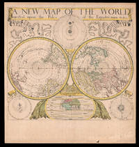
A New Map of the World Projected upon the Poles of the Equator: By Will. Berry.
by BERRY, William
- Used
- Condition
- Used
- Quantity Available
- 1
- Seller
-
London, United Kingdom
- Item Price
-
NZ$64,239.00NZ$32.12 shipping to USA
Show Details
Description:
London,: Sold by Will Berry at the Signe of the Globe between Chearing-Cross and White-Hall,, [c1680].. 425 by 480mm (16.75 by 19 inches).. The first polar projection world map published by an Englishman Engraved map, fine original hand-colour, Ptolemaic, Tychonic, and Copernican diagrams of the solar system around map, map of the ancient world below. The first world map on polar projection to be published by an Englishman. Polar Projection Polar projection is a type of azimuthal projection based on a plane perpendicular to the Earth's axis through the poles. On polar-centered azimuthal projections, longitude is represented by radial straight lines, and latitude by concentric circles, or parallels. One of the earliest examples of a polar map of this kind is Mercator's 1569 world map, on which the Arctic is shown in an inset map on a polar projection, rather than included as part of the main image on the eponymous cartographer's projection. Other early double hemisphere world maps on north and…
Read More Item Price
NZ$64,239.00
NZ$32.12
shipping to USA

A New Map of the Island of Minorca, Port Mahone &c.: A twin map of Minorca and Gibraltar Taken by General Stanhope the 18 of September 1708, and by the Treaty of Utrecht in 1713 was together with Gibraltar yielded for ever to the Crown of Great Britain. Sold by H. Moll; A New and Exact Map of the City and B
by MOLL, Herman
- Used
- Condition
- Used
- Quantity Available
- 1
- Seller
-
London, United Kingdom
- Item Price
-
NZ$1,927.17NZ$32.12 shipping to USA
Show Details
Description:
London,: Herman Moll,, 1727.. Two engraved maps on the same sheet with hand colouring. Very scarce composite plate with separate maps of Minorca (157 x 173 mm) and Gibraltar (110 x 106 mm), the principal acquisitions of the British in the Mediterranean from the Treaty of Utrecht (1713). It is assumed that the plate was first engraved in 1713 or 1714; the only example of this first state encountered came from the Macclesfield's collection. The joint imprint of Moll and John King sr. places this printing in the mid-1720s, no doubt during the siege of 1727. The title-page of the second edition of Jacques Ozanam's A Treatise of Fortification notes 'To which is prefix'd a PLAN of Gibraltar, &c. with all its Fortifications as they are at present, shewing the great Strength and Use of it, &c. Humbly Inscribed to the Right Honourable the E. of Portmore' (London: J. Jackson and John Worrall, 1727), which would imply map 34 above, but the only recorded copy (Sotheby's, Library of the Earls of Macclesfield,…
Read More Item Price
NZ$1,927.17
NZ$32.12
shipping to USA

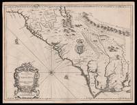
A New Map of the Island of Barbadoes: First systematic map of the island wherein every Parish, Plantation, Watermill, Windmill and Cattlemill is described with the name of the Present Possessor.
by LEA, Philip; FORD, Richard
- Used
- Condition
- Used
- Quantity Available
- 1
- Seller
-
London, United Kingdom
- Item Price
-
NZ$8,565.20NZ$32.12 shipping to USA
Show Details
Description:
London,: By Phillip Lea at ye Atlas & Hercules in ye Poltry over against ye ould Jury and by John Sellers at his shop on the West side of the Royal Exchange,, [c.1682].. 530 by 610mm. (20.75 by 24 inches).. Hand-coloured engraved map. This very rare map is the earliest systematic survey of Barbados. Produced from the surveys of Richard Ford during the 1670s it shows the already extensive nature of sugar cultivation throughout the island. The map is oriented with north to the right by a large compass rose. Each of the island's eleven parishes, as established in 1645, are located and named. Each land plot and plantation (844) is identified with the proprietor's name and only six small patches of native forest remain uncultivated. The celebrated sugar mills throughout the island are located and shown with icons identified in a key as either windmill, watermill, or cattlemill - all which are employed in the grinding of sugar canes. The map is embellished with small vignettes of local plants such as the…
Read More Item Price
NZ$8,565.20
NZ$32.12
shipping to USA

A New Map of Ireland: Moll's large map of Ireland Divided into its Provinces, Counties, and Baronies, wherein are Distinguished the Bishopricks, Borroughs, Barracks, Bogs, Passes, Bridges, &c., with the Principal Roads, and Common Reputed Miles.
by MOLL, Herman
- Used
- Condition
- Used
- Quantity Available
- 1
- Seller
-
London, United Kingdom
- Item Price
-
NZ$4,282.60NZ$32.12 shipping to USA
Show Details
Description:
London,: Printed for H. Moll over against Devereux Court in ye Strand. I. Bowles at the Black Horse in Cornhill. P. Overton Map and Printseller next to the Chapter House in St. Pauls Church Yard. And by I. King Map and Printseller at the Globe in the Poultry,, 1714.. 1025 by 620mm. (40.25 by 24.5 inches).. Engraved map with original outline colour. An elegant and detailed map of Ireland, showing its division into four provinces and thereafter into countries. It is supplemented by five plans of important cities: Dublin, Cork, Limerick, Waterford and Galway. Moll also includes views of notable places in Ireland: Kinsale Harbour, where Charles II was declared king after his father's execution, and where James II fled England after the Glorious Revolution; the Giant's Causeway, basalt columns supposedly built by warring giants; and the Isle of Saint Patrick's Purgatory, a pilgrimage site in County Donegal where Jesus supposedly showed Patrick an entrance to Purgatory. Finally, there is a table at the…
Read More Item Price
NZ$4,282.60
NZ$32.12
shipping to USA

A New Map of New England.: The first plan of New York harbour New York. New Iersey. Pensilvania. Maryland. and Virginia.
by THORNTON, John, MORDEN, Robert & LEA, Philip
- Used
- first
- Condition
- Used
- Quantity Available
- 1
- Seller
-
London, United Kingdom
- Item Price
-
NZ$47,108.60NZ$32.12 shipping to USA
Show Details
Description:
London,, [c1685].. 450 by 550mm. (17.75 by 21.75 inches).. First state. Double-page engraved map (450 by 550mm to the neatline, full margins showing the plate mark), with early hand-colour in outline (one or two pale stains). "In May 1685 John Thornton, Robert Morden and Philip Lea advertised for sale a multi-sheet map entitled 'A New Map of the English Empire in the Continent of America'. Although earlier multi-sheet maps of the Americas existed, namely the Augustine Herrman 1673[74], none survive that were of the entire English colonies in North America" (Burden). The only known example of their advertised map is held in the Bibliothéque Nationale, Paris. The multi-sheet map was designed in such a manner that allowed for some of the sheets to be issued separately, as in the present example: "This can be shown by the fact that the title runs in a narrow border along the top, so that when made up as a wall map it may be pasted or cut out. A main area of the debate is whether the map appears in an…
Read More Item Price
NZ$47,108.60
NZ$32.12
shipping to USA

A New Map of Scotland, for Ladies Needlework.: Needlework map of Scotland
by LAURIE, Robert & WHITTLE, James
- Used
- Condition
- Used
- Quantity Available
- 1
- Seller
-
London, United Kingdom
- Item Price
-
NZ$1,605.98NZ$32.12 shipping to USA
Show Details
Description:
London,: Published by Laurie & Whittle, No. 53 Fleet Street,, 1797.. 470 by 410mm. (18.5 by 16.25 inches).. Engraved map on silk with hand sewn embroidery. Rare silk map sampler. From the 1770s to the 1840s embroidered maps or map samplers were part of a young ladies education in England and the United States, demonstrating both her grasp of geography and her skill at needlework. "By the end of the eighteenth century it became possible to print from an engraved copper plate onto silk, and several British map publishers, especially those which were producing other educational products such as dissected maps, began to print not only paper map patterns, but also engraved maps on silk or satin "for young ladies' needlework".... the Dartons, Bowles & Carver, John Spilsbury and Laurie & Whittle were the major names. All were map publishers, and they were also involved in the popularity of games and dissected maps. Laurie & Whittle, located in Fleet Street in London, produced a number of silk printed…
Read More Item Price
NZ$1,605.98
NZ$32.12
shipping to USA

A New Mapp of the Whole World.: The Chinesian Ocean"
by OVERTON, Henry
- Used
- Condition
- Used
- Quantity Available
- 1
- Seller
-
London, United Kingdom
- Item Price
-
NZ$248,390.80NZ$32.12 shipping to USA
Show Details
Description:
London,: Henry Overton,, 1738.. 1498 by 1600mm. (59 by 63 inches).. Engraved map on four sheets, with fine original hand-colour. Henry Overton (1676-1751) was a publisher and mapseller who followed in the footsteps of his father, John Overton, when he took over his shop and stock in 1707. Over the course of his career he published a large number of maps, as well as numerous views, portraits and sporting prints. Overton's maps were largely focused on the British Isles, and he also produced revised and updated editions of John Speed's country atlas. One of his most visually striking and rarest works, however, is 'A New Mapp of the World by Henry Overton'. The map describes the world in two hemispheres, with two smaller pairs of hemispheres above and below, showing the heavens and the polar regions respectively. This design reflects the world maps published by Gerard Valk at the end of the seventeenth century, but Overton's geographical configuration is notably less sophisticated, corresponding more…
Read More Item Price
NZ$248,390.80
NZ$32.12
shipping to USA

A New Mapp of the North part of America: Thornton's first published chart from Hudson Straights commanly call'd the Nor West Passage. Including Newfoundland New Scotland New England Virginia Maryland & Carolena.
by THORNTON, John
- Used
- first
- Condition
- Used
- Quantity Available
- 1
- Seller
-
London, United Kingdom
- Item Price
-
NZ$128,478.00NZ$32.12 shipping to USA
Show Details
Description:
London,: Made and sold by John Thornton at the signe of England, Scotland & Ireland in the Minories,, 1673.. 435 by 540mm (17.25 by 21.25 inches).. Double-page engraved map (432 by 554mm to the neatline, full margins showing the platemark). Separately issued, and exceptionally rare, this is Thornton's first published chart; the first printed map to show the activities of the Hudson's Bay Company; and the second printed map to show features of Lederer's discoveries. "This map, formerly dated tentatively 'ca. 1680,' was advertised for sale in the London Gazette for 20-24 February 1673." (Cumming, The Southeast in Early Maps, 89). A superb map of New England, Hudson Bay, eastern Canada, with an inset of the American southeast and mid-Atlantic coastline within a fine asymmetrical rococo cartouche lower left, and the title within another upper right, decorated with native animals, a galleon and three compass roses. The inset of the southern colonies is not some "casual insertion, some effort has been put…
Read More Item Price
NZ$128,478.00
NZ$32.12
shipping to USA

A New Mapp of the Kingdom of England,: The definitive edition of Christopher Browne's monumental wall map of England and Wales shewing Its Antient and Present Government being Divided as in the Saxon-Heptarchy also in the Diocesis, Judges-Circiutts and Countyes Describing all the Citys, Market
by BROWNE, Christopher
- Used
- Condition
- Used
- Quantity Available
- 1
- Seller
-
London, United Kingdom
- Item Price
-
NZ$21,413.00NZ$32.12 shipping to USA
Show Details
Description:
London,: Printed and Sold by Robert Sayer Map and Print Seller over against St. Dunstans Church in Fleet Street, & Tho. Bowles Map & Print Seller, next to the Chapter house in St. Paul's, Church Yard,, 1735 [but c.1760].. 1660 by 1660mm. (65.25 by 65.25 inches).. Large engraved wall map, dissected and mounted on linen, elaborate title cartouche upper right, the explanation to map lower right, slightly age-toned. Christopher Browne's monumental wall map of England and Wales. Christopher Browne (fl.1688-1712) was apprenticed to Robert Walton and after his death in 1688 took over his stock. He was not prolific with his production and all material associated with him is scarce. The largest item we know of is this wall map on 15 sheets. The map was first issued by Browne in 1700. The work is hugely detailed depicting cities, town, villages, gentlemen's seats; roads (according to Ogilby) are marked with distances; as are the boundaries of the Anglo-Saxon Heptarchy, counties, dioceses, and judges'…
Read More Item Price
NZ$21,413.00
NZ$32.12
shipping to USA

A New Plan of London, XXIX Miles in Circumference.: London docks and the Croydon Canal
by STOCKDALE, John
- Used
- Condition
- Used
- Quantity Available
- 1
- Seller
-
London, United Kingdom
- Item Price
-
NZ$17,130.40NZ$32.12 shipping to USA
Show Details
Description:
London,: Printed by J. Stockdale, Piccadilly,, Jany. 2nd 1797 [but c1809].. 1050 by 1500mm (41.25 by 59 inches).. Engraved map on four sheets, a few tears to old folds skilfully repaired. This large and detailed plan of London is very similar stylistically to much of the output of John Rocque, although Stockdale is somewhat sparser, with few baroque flourishes. The plan is dated 1797, yet it was clearly issued some twelve years late as it not only shows the West India Docks (opened in 1802), the London Docks (opened in 1805), and the East India Docks (opened in 1806), but also the Croydon Canal, which was not in use until 1809. Also shown are the intended routes, marked by dotted lines, of Regent's Bridge (later renamed Vauxhall Bridge), and Waterloo Bridge. Scale: 6 1/2 inches to one statute mile. Howgego 21Green Room3 (2).
Item Price
NZ$17,130.40
NZ$32.12
shipping to USA

Didn’t find what you’re looking for?
Try adding this search to your want list. Millions of books are added to our site everyday and when we find one that matches your search, we’ll send you an email. Best of all, it’s free.
Add to Want List

Are you a frequent reader or book collector?
Join the Bibliophile's Club and save 10% on every purchase, every day — up to $20 savings per order!

Social Responsibility
Did you know that since 2004, Biblio has used its profits to build 16 public libraries in rural villages of South America?
