Description:
Chicago,, 1948.. 364 by 482mm. (14.25 by 19 inches).. Chromolithograph map. A lively pictorial map of Chicago Zoo, chartered as the Chicago Zoological Society in 1921 and opened as Brookfield Zoo in 1934, on land donated by Edith Rockefeller McCormick in 1919. The map's artist, Ralph Graham (1901-1980), was born in Cheyenne. He graduated from Chicago Institute of Art in 1930, and exhibited at Chicago's Century of Progress World's Fair in 1933. Given the Zoo map's similarity in style to the famous, but anonymous, 'Map of Chicago's Gangland', 1931, it seems very likely that Graham may have been responsible for that map too. Between 1935 and 1936, he was acting as supervisor of applied arts under the Works Progress Administration, when he visited the Zoo, and oversaw the creation of tabletops for the refectory, featuring animal figures, set in the new medium of inlaid Formica. He volunteered for service during WWII, and on his return, in 1948, Director Robert Bean appointed Graham as assistant…
Read More Search Results: Titles starting with O from Daniel Crouch Rare Books Ltd
You searched for:
- Bookseller inventory: Daniel Crouch Rare Books Ltd (titles starting with O)
- Bookseller: Daniel Crouch Rare Books Ltd
Results 1 - 13 of 13

Official Map: Chicago Zoological Park: Chicago Zoo Brookfield near Riverside. John T. McCutcheon, President. Director, Robert Bean.
by GRAHAM, Ralph Wadsworth
- Used
- Condition
- Used
- Quantity Available
- 1
- Seller
-
London, United Kingdom
- Item Price
-
NZ$849.44NZ$31.85 shipping to USA
Show Details
Item Price
NZ$849.44
NZ$31.85
shipping to USA
![[Offset staff].](https://d3525k1ryd2155.cloudfront.net/h/373/506/1391506373.1.m.jpg)
More Photos
[Offset staff].: Surveyor's offset staff
- Used
- Condition
- Used
- Quantity Available
- 1
- Seller
-
London, United Kingdom
- Item Price
-
NZ$15,927.00NZ$31.85 shipping to USA
Show Details
Description:
c1850.. Mahogany staff (4 feet 9 inches) with steel shod pointed foot, the pole 1 inch dia., 4 inch dia. hard ball. A finely made example of an offset staff. The instrument consists of a turned wooden pole. At one end is a metal spike so that the pole can be easily driven into the ground. On the other end is a wooden ball with a cross-slight. The instrument was designed to measure off sets, that is, to locate objects that are at a 90 degree angle to the surveying centreline.
Item Price
NZ$15,927.00
NZ$31.85
shipping to USA
More Photos
Onderwys in 't Regte Gebruyk van het Hemels-Plyn: Telling the time with stars strekkende tot nut en vermaak der liefhebbers.
by STAMPIOEN, Jan Jansz the Younger, [and] Marten CALMAM
- Used
- Hardcover
- Condition
- Used
- Binding
- Hardcover
- Quantity Available
- 1
- Seller
-
London, United Kingdom
- Item Price
-
NZ$84,944.00NZ$31.85 shipping to USA
Show Details
Description:
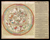
Amsterdam,: Jochem Hasebroek,, [c1722].. 500 by 630mm. (19.75 by 24.75 inches).. Large engraved celestial chart by Stampioen with a rotating printed paper ring (volvelle or rete) on an off-centre axis to indicate the part of the sky visible at any date and time and to make a variety of celestial calculations, all for the Netherlands' latitude of 52 degrees. With letterpress instructions by Calman on a separate slip at the right. The sky image 33 cm in diameter; the whole chart with the letterpress slip as mounted 49 x 61.5 cm. A string with a bead serves as a pointer for aligning the scales in the stationary and rotating parts. Coloured by a contemporary hand and mounted on contemporary boards covered with marbled paper, apparently by the publisher, so that it can be folded in half for carrying. The chart is here in its third state, but we have located no complete example of any earlier version. The Boerhaave Museum in Leiden has the chart without volvelle or instructional text, published by Doncker,…
Read More Item Price
NZ$84,944.00
NZ$31.85
shipping to USA

Onderwysing van't Gebruyk des Hemels Pleyn: Vooght's rare star chart and astronomical calculator Waar op de starren des hemels na 't oogh in 't plat gestelt zyn[.] Tot nut en vermaak van alle liefhebbers der wiskonsten.
by VOOGHT, Claes Jansz. [after] Jan Jansz STAMPIOEN
- Used
- Hardcover
- Condition
- Used
- Binding
- Hardcover
- Quantity Available
- 1
- Seller
-
London, United Kingdom
- Item Price
-
NZ$84,944.00NZ$31.85 shipping to USA
Show Details
Description:
Amsterdam,: Johannis van Keulen,, [c1680-1696].. 560 by 660mm. (22 by 26 inches).. Large engraved celestial chart with a rotating printed paper ring (volvelle or rete) on an off-centre axis to indicate the part of the sky visible at any date and time and to make a variety of celestial calculations, all for the Netherlands' latitude of 52 degrees. A string with two beads serves as a pointer for aligning the scales in the stationary and rotating parts. With engraved instructions also by Vooght. Coloured by a contemporary hand and mounted on contemporary boards covered with marbled paper, apparently by the publisher, so that it can be folded in half for carrying. The string may be a modern replacement. Vooght's rare star chart and astronomical calculator, here separately issued in portfolio form and in its first state. The chart shows the stars visible from 52 degrees latitude in a polar equidistant projection, with a rotating volvelle or rete to indicate the part of the sky visible at a particular…
Read More Item Price
NZ$84,944.00
NZ$31.85
shipping to USA

Orbi Spectandum Galleus Ortelium.
by [GALLE, Philips; after Adriaen Thomaszoon KEY]
- Used
- first
- Condition
- Used
- Quantity Available
- 1
- Seller
-
London, United Kingdom
- Item Price
-
NZ$2,123.60NZ$31.85 shipping to USA
Show Details
Description:
[Antwerp,: Plantin,, 1579].. 387 by 280mm (15.25 by 11 inches).. Prints,""Spectandum dedit Ortelius mortalib. orbem, Abraham Ortelius Engraved portrait, with letterpress text to verso. Galle's iconic image of Ortelius, based on an original portrait by Adriaen Key, was included in every edition of Ortelius's atlas of the world from 1579, the 'Theatrum orbis terrarum'. It is captioned in Latin, """"Spectandum dedit Ortelius mortalib. orbem, Orbi Spectandum Galleus Ortelium"""" ('Ortelius allowed mortals to see the world, Galle allows world to see Ortelius'). Indeed, the engraver of the portrait was Philips Galle, who published the first miniature version of Ortelius's 'Theatrum...' in 1577, under the title 'Epitome Theatri Orteliani'. Adriaen Key's (c1544-1589) is the only known portrait of Abraham Ortelius to have been painted during his lifetime. Like Ortelius, he was a native of Antwerp, and became one of the leading portraitists in that city. He became a master in Antwerp's Guild of St. Luke (the…
Read More Item Price
NZ$2,123.60
NZ$31.85
shipping to USA

Orbis Typus Universalis Iuxta Hydrographorum Traditionem.: The Admiral's map
by PTOLEMAEUS, Claudius; Martin WALDESEEMULLER
- Used
- first
- Condition
- Used
- Quantity Available
- 1
- Seller
-
London, United Kingdom
- Item Price
-
NZ$169,888.00NZ$31.85 shipping to USA
Show Details
Description:
Strassburg,: Johannes Schott,, 12th March, 1513. 465 by 608mm. (18.25 by 24 inches).. Double-page woodcut map of the world, lower margin extended. The so-called Admiral's Map; the first of two maps in Waldseemuller's atlas that relate New World discoveries, and is referred to in the index as the 'Hydrographia sive Charta marina', and in the 'Ad Lectorem' as the 'Charta Marina', where it is clearly stated that the geographical facts have been made known "through the most authentic voyages of a former Admiral of the most serene King of Portugal, Ferdinand, and those of other explorers" (The Admiral's Map What Was It? And Who the Admiral? Samuel Mc Coskry Stanton, Isis, Vol. 22, No. 2. (Feb., 1935), pp. 511-515). The map was created for inclusion in the Strassburg edition of Ptolemy's 'Geographia', signaling the beginning of the section of twenty modern maps which were added to the twenty-seven Ptolemaic originals. This world map gives a more accurate outline of eastern Asia than Ptolemy. It contains…
Read More Item Price
NZ$169,888.00
NZ$31.85
shipping to USA

Ordnance Survey of England and Wales, and Part of Scotland.: Complete set of the Ordnance Survey of England and Wales in a fine presentation box
by MUDGE, Lieutenant Colonel (later Major General) William; COLBY, Major Thomas; BAKER, Benjamin and others
- Used
- Hardcover
- Condition
- Used
- Binding
- Hardcover
- Quantity Available
- 1
- Seller
-
London, United Kingdom
- Item Price
-
NZ$25,483.20NZ$31.85 shipping to USA
Show Details
Description:
[London,: Henry James,, c1870].. each sheet approximately 680 by 980mm (26.75 by 38.5 inches).. 111 hand-coloured engraved maps (including index map) printed in electrotype at the Ordnance Survey Office, each dissected and mounted on linen, with numbered vellum tabs, preserved in purpose-made wooden map chest, lettered on front 'Ordnance Maps of England'. Dimensions: chest: 1100L x 410H x 340D mm (43 x 16 x 13 in); each map (approximately): 680 x 980mm (26.75 by 38.5 in). The traditional foundation date for the Ordnance Survey has often been taken as the 21st of June 1791, when the Third Duke of Richmond, then Master-General of the Ordnance, authorised the purchase, with state funds, of a giant theodolite for £373.70. However, many writers have looked further back to such projects as the military survey of Scotland, which was executed between 1747-1755, and was the first major land survey carried out by the state. One of its surveyors, William Roy (1726-1790), would go on to make proposals in…
Read More Item Price
NZ$25,483.20
NZ$31.85
shipping to USA
![[Ottoman atlas]](https://d3525k1ryd2155.cloudfront.net/h/005/505/1391505005.0.m.jpg)
More Photos
[Ottoman atlas]: Australia, Oceania, World
- Used
- Condition
- Used
- Quantity Available
- 1
- Seller
-
London, United Kingdom
- Item Price
-
NZ$1,805.06NZ$31.85 shipping to USA
Show Details
Description:
[Istanbul, , c1914].. 245 by 188mm. (9.75 by 7.5 inches).. A separately published blank Ottoman atlas with maps of Australia, Oceania and the World. 8°, 36-42 pp., facing pages marked with the same number, with colour lithographed plates, printed covers, stapled. Small tears in margins, some sheets including the wrappers loose, staple rusty and broken, soft folds, slightly age-toned and stained, some ink staining on the wrappers, otherwise in a good used condition. An unusual Ottoman geography exercise book, focusing on Oceania, Australia and the World, was published for students. Each map is accompanied on the opposite page by a blank grid of equal size, upon which students were meant to duplicate the map in their own hand. The maps are not marked with any names nor locations. The maps showcase Oceania, South East Asia, Australia, Map of the World with marked, what we surmise is the historical trading area of the Ottoman Empire, Western hemisphere, Eastern Hemisphere, and the two pole…
Read More Item Price
NZ$1,805.06
NZ$31.85
shipping to USA

More Photos
Oxonia Illustrata: Oxford from above extra-illustrated with Richard Rallingson's 'Ichnographia Oxoniae', 1648 plan of the defences of Oxford during the civil war sive Omnium Celeberrimae istius Universitatis Collegiorum Aularum, Bibiliothecae Bodleiane, Scholarum Publicarum
by LOGGAN, David
- Used
- Hardcover
- first
- Condition
- Used
- Binding
- Hardcover
- Quantity Available
- 1
- Seller
-
London, United Kingdom
- Item Price
-
NZ$31,854.00NZ$31.85 shipping to USA
Show Details
Description:
Oxoniae,: E Theatro Sheldoniano,, 1675.. First edition. Folio (435 by 300mm). Engraved title-page, dedication to Charles II, preface leaf, privilege leaf dated 17 March 1672/3, double-page plan of Oxford and 39 copper-plate views, 1 folding, 38 double-page, extra-illustrated with Richard Rallingson's 'Ichnographia Oxoniae', 1648 plan of the defences of Oxford during the civil war from Anthony Wood's 'Historia et antiquitates universitatis oxoniensis', 1675, engraved index. Finely bound in contemporary and polished red morocco. Backstrip with raised bands and gilt decoration, compartments gilt panelled, upper and lower covers with double fillet outer and inner borders, centre panel with gilt lunette border, fleuron corners, a.e.g. First edition of Loggan's work with views of Oxford and the University. The first illustrated book on Oxford and one of the major works of the seventeenth century, the product of several years devoted and conscientious effort in which Loggan was assisted by his pupil…
Read More Item Price
NZ$31,854.00
NZ$31.85
shipping to USA

of Single Wicket will be played at Garratt's Ground, Copenhagen House, Tuesday October 6, 1846, between four gentlemen of the Copenhagen Ground, against four gentlemen of the City Club, Held at The Northapton Arms, Islington, for £30. A side.
by WRIGHT, [William]
- Used
- Condition
- Used
- Quantity Available
- 1
- Seller
-
London, United Kingdom
- Item Price
-
NZ$1,592.70NZ$31.85 shipping to USA
Show Details
Description:
[London],: Wright, Printer, 12, Fulwood's Rents, Holborn., 1846.. 406 by 271mm. (16 by 10.75 inches).. Prints,""[Cricket] A Grand Match!! Howzat! Broadside advertisement with woodcut image of a single wicket cricket match above letterpress text advertisement. Copenhagen House Grounds in Islington was the leading venue for professional athletics until it closed in December 1853 after severe storm damage. Initially consisting of a 200-yard straight, an oval gravel track was added, opening on 17 March 1851, thought to be one third of a mile in length, enclosing a cricket pitch. Single wicket cricket is a form of the game played between two individuals, who take turns to bat and bowl against each other. The one bowling is assisted by a team of fielders, who remain as fielders at the change of innings. The winner is the one who scores more runs. Below the main text is: """"The following is a list of the players. Copenhagen: Messrs. Dewdney, Golding Messrs. Rogers, Paul - City: Messrs. Figg, Hodson…
Read More Item Price
NZ$1,592.70
NZ$31.85
shipping to USA
![[on sheet with] Plan du Port Palliser, dans la Terre de Kerguelen [and] Plan du Havre de Noel,...](https://d3525k1ryd2155.cloudfront.net/h/184/598/1456598184.0.m.jpg)
[on sheet with] Plan du Port Palliser, dans la Terre de Kerguelen [and] Plan du Havre de Noel, dans la Terre de Kerguelen.
by BONNE, Rigobert; and COOK, Captain James
- Used
- Condition
- Used
- Quantity Available
- 1
- Seller
-
London, United Kingdom
- Item Price
-
NZ$318.54NZ$31.85 shipping to USA
Show Details
Description:
[Pardoue,: Rigobert Bonne and Nicolas Desmarest, , 1789-1790].. 290 by 410mm. (11.5 by 16.25 inches).. Maps,""Terre de Kerguelen, Appellee par M. Cook, Isle de la Desolation Cook's Christmas Four charts on a single mapsheet, with contemporary hand-colour in outline. Published in the 'Atlas encylopédique', a French compilation of voyages including a French translation of the journals of his third voyage. The main chart depicts Kerguelen Island, or Desolation Island, in the southern Indian Ocean, which Captain James Cook visited on his third voyage in December 1776, finding shelter from a storm there on Christmas Day. The central map shows Cook's track around the south of the island, with the incorrect date of 1772. The sheet also includes two detailed charts of harbours on the island: 'Plan du Port Palliser, dans la Terre de Kerguelen'; and 'Plan du Havre de Noel, dans la Terre de Kerguelen', as well as an inset bottom left showing two islands discovered by Cook and Marion du Fresne.
Item Price
NZ$318.54
NZ$31.85
shipping to USA

More Photos
or Views of the Bodleian Library, the Theatre, Publick Schools, Colleges, Halls, and other Publick Buildings of the University of Oxford, with an account of their Foundations and Endowments and a succinct description of the Buildings
by OVERTON, Henry; and HOOLE, John; after LOGGAN, David
- Used
- Condition
- Used
- Quantity Available
- 1
- Seller
-
London, United Kingdom
- Item Price
-
NZ$10,618.00NZ$31.85 shipping to USA
Show Details
Description:
London,: Printed and Sold by H. Overton and J. Hool at the White Horse without Newgate, London, where may be had any of the Colleges of Oxford or Cambridge, each of them printed on a Sheet of Royal Paper & neatly graved by D. Loggan, [c1710].. 590 by 975mm. (23.25 by 38.5 inches).. Prints,""Oxonia Illustrata, An extravagant broadsheet advertisement for Overton's edition of Loggan Engraving, printed on two joined sheets. A very large, rare, and separately published advertisement for Overton's issues of David Loggan's celebrated 'Oxonia Illustrata', the plates for which were acquired by Overton, or his father John, at some point during the decade following Loggan's death in 1692. A partner, showing Loggan's Cambridge views, was likely printed at the same time, though the exact date of publication for both is unknown, and it is unclear whether the pair were intended to advertise Overton's reprints of 'Oxonia Illustrata' and 'Cantabrigia Illustrata' in 1705 and 1715 respectively, or simply that he was…
Read More Item Price
NZ$10,618.00
NZ$31.85
shipping to USA

or the Straits to the East of Java, with a part of the Banda Sea. Corrected and Improved, chiefly from the Observations of Captin. R. Williams.
by LAURIE, Robert; and James WHITTLE
- Used
- Condition
- Used
- Quantity Available
- 1
- Seller
-
London, United Kingdom
- Item Price
-
NZ$1,592.70NZ$31.85 shipping to USA
Show Details
Description:
London,: Laurie & Whittle, , 12th Oct.r 1798.. 470 by 640mm. (18.5 by 25.25 inches).. Maps,""A New Chart of the Eastern Straits, A dramatic vignette of the Gut of Larantooca Engraved chart on two sheets, joined. An elegant and large-scale chart of the straits surrounding part of the Indonesian archipelago from Bali to Timor. With an inset vignette of the 'Entrance of the Straits or Gut of Larantooca from the Northward ... by Capt.n Rob.t Williams 1797...', and numerous other equally fine coastal profiles. Laurie & Whittle's 'East India Pilot' was published as a practical guide to navigators aboard ships of the Royal Navy and East Indiamen, and often taken to sea, and this chart appears to be no exception. All variants of Laurie and Whittle's 'Oriental' pilots of eastern waters are scarce, and were published under several titles, each with a different complement of charts. Variants include: 'The Country Trade East-India Pilot, for the Navigation of the East-Indies and Oriental Seas, within the limits…
Read More Item Price
NZ$1,592.70
NZ$31.85
shipping to USA

Didn’t find what you’re looking for?
Try adding this search to your want list. Millions of books are added to our site everyday and when we find one that matches your search, we’ll send you an email. Best of all, it’s free.
Add to Want List

Are you a frequent reader or book collector?
Join the Bibliophile's Club and save 10% on every purchase, every day — up to $20 savings per order!

Social Responsibility
Did you know that since 2004, Biblio has used its profits to build 16 public libraries in rural villages of South America?
