Description:
[Leiden,, 1588].. (plate) 200 by 280mm (7.75 by 11 inches); (sheet) 250 by 330mm (9.75 by 13 inches).. Engraved map. The present view of St Augustine, Florida (together with views of Santo Domingo in the Dominican Republic; Santiago in the Cape Verde Islands; and Cartagena in Columbia) were drawn, and probably engraved, by the Italian artist Baptista Boazio. The Boazio views are "probably the most interesting and important published graphic work pertaining to Drake and his career" (Kraus). They are also the first representations of those four cities. Indeed, the view of St Augustine is the first known engraving of any locality in the present-day United States. Their history is uncertain. Having famously circumnavigated the globe between 1577 and 1580, Sir Francis Drake voyaged to North and Central America in 1585, where he ransacked many of the towns shown in Boazio's engravings. There is no indication that Boazio participated to the voyage but he must have obtained a version of these views from…
Read More Search Results: Titles starting with S from Daniel Crouch Rare Books Ltd
You searched for:
- Bookseller inventory: Daniel Crouch Rare Books Ltd (titles starting with S)
- Bookseller: Daniel Crouch Rare Books Ltd
Results 1 - 20 of 74

S. Augustin.: The first known engraving of any locality in the present-day United States
by [?BOAZIO, Giovanni Battista]
- Used
- first
- Condition
- Used
- Quantity Available
- 1
- Seller
-
London, United Kingdom
- Item Price
-
NZ$214,200.00NZ$32.13 shipping to USA
Show Details
Item Price
NZ$214,200.00
NZ$32.13
shipping to USA

S. Dominico: The first printed view of Santo Domingo Civitas S. Dominici sita in Hispaniola Indica Angliae magnitudine fere aequalis, ipsa urbs eleganter ab Hispanis extructa, et omnibus circum Vicinis Ins: jura dat.
by [?BOAZIO, Giovanni Battista]
- Used
- first
- Condition
- Used
- Quantity Available
- 1
- Seller
-
London, United Kingdom
- Item Price
-
NZ$42,840.00NZ$32.13 shipping to USA
Show Details
Description:
[Leiden,, 1588].. 245 by 329mm. (9.75 by 13 inches).. Engraved map with contemporary manuscript number. The present view of Santo Domingo in the Dominican Republic (together with views of San Augustine, Florida, Santiago in the Cape Verde Islands and Cartagena in Columbia) were drawn, and probably engraved, by the Italian artist Baptista Boazio. The Boazio views are "probably the most interesting and important published graphic work pertaining to Drake and his career" (Kraus). They are also the first representations of those four cities. Indeed, the view of San Augustine is the first known engraving of any locality in the present-day United States. Having famously circumnavigated the globe between 1577 and 1580, Sir Francis Drake voyaged to North and Central America in 1585, where he ransacked many of the towns shown in Boazio's engravings. There is no evidence of Boazio's participation in any voyage to the New World, but he must have obtained a version of these views from someone who had travelled…
Read More Item Price
NZ$42,840.00
NZ$32.13
shipping to USA

S. Iacob.: The first printed view of Santiago, Cape Verde Civitas S. Iacobi eo nomine quo insula vocatur, et commercium habet cum Guyneo et adiuctis regionibus Africae, unde merces in Lusitaniam devehunt. La citte de Sainct Jacques ditte du nom de lisle traficque av
by [?BOAZIO, Giovanni Battista]
- Used
- first
- Condition
- Used
- Quantity Available
- 1
- Seller
-
London, United Kingdom
- Item Price
-
NZ$25,704.00NZ$32.13 shipping to USA
Show Details
Description:
[Leiden,, 1588].. 246 by 329mm. (9.75 by 13 inches).. Engraved map with contemporary manuscript number, guard affixed to left margin. The present view of Santiago in the Cape Verde Islands (together with views of San Augustine, Florida, Santo Domingo in the Dominican Republic and Cartagena in Columbia) were drawn, and probably engraved, by the Italian artist Baptista Boazio. The Boazio views are "probably the most interesting and important published graphic work pertaining to Drake and his career" (Kraus). They are also the first representations of those four cities. Indeed, the view of San Augustine is the first known engraving of any locality in the present-day United States. Having famously circumnavigated the globe between 1577 and 1580, Sir Francis Drake voyaged to North and Central America in 1585, where he ransacked many of the towns shown in Boazio's engravings. There is no evidence of Boazio's participation in any voyage to the New World, but he must have obtained a version of these views…
Read More Item Price
NZ$25,704.00
NZ$32.13
shipping to USA

SAC. CAES. REGq CATH. MAJ. Geographus, nec non Regiae Scientiarum. Societatis Berolinensis Membrum.
by WINTER, Jo[hann] Wilhelm; [after] Joannes KEENCKEL
- Used
- Condition
- Used
- Quantity Available
- 1
- Seller
-
London, United Kingdom
- Item Price
-
NZ$1,713.60NZ$32.13 shipping to USA
Show Details
Description:
[Nuremberg,: Jo[hann] Wilhelm Winter,, c1716-1724].. 270 by 370mm. (10.75 by 14.5 inches).. Prints,""Ionnes Baptista Homann. Johann Baptiste Homann Engraved portrait. Johann Baptiste Homann (1664-1724) was a German map publisher who founded a firm in Nuremberg in 1702, after studying in Vienna. In 1715, he was appointed to the prestigious position of imperial cartographer to the Holy Roman Emperor, Charles VI, and in the same year also became a member of the Royal Academy of Sciences in Berlin. Having published hundreds of individual maps, Homann's first atlas appeared in 1707, and in 1716 he published the 'Grosser Atlas uber die ganze Welt', which would come to be known as his masterpiece. After his death, the firm was taken over by his sons, who continued to produce cartographical materials. This portrait shows Homann seated at a desk in front of a large bookcase, wearing elaborate robes and a great powdered wig. He is using a pair of compasses to plot a chart unfurled on the surface in front…
Read More Item Price
NZ$1,713.60
NZ$32.13
shipping to USA

SCAM DELUXE: The Game of International Drug Smuggling.: Occasionally, everyone gets too far out"
- Used
- Condition
- Used
- Quantity Available
- 1
- Seller
-
London, United Kingdom
- Item Price
-
NZ$10,710.00NZ$32.13 shipping to USA
Show Details
Description:
Berkeley,: Brown Bag Enterprises,, 1971.. Everything needed to play Scam, including: a folding game board printed in colours on coated stock; the "Scam" rules sheet; a colour printed paper over pasteboard spinner metal smugglers' spinner; "Connection" cards printed on blue card stock; "Paranoia" cards on red stock; sheets of ersatz money; 4 plastic playing pieces and two tiny die. With original cardboard printed box illustrated with joints, a marijuana leaf and inset maps that appear in the game. This is the second "Deluxe" edition of the Scam board game, offered in a box rather than the "joint" tube, though illustrated joints feature prominently on the box's cover, serving as a backdrop for the title. Like the original, the board game offers a high stakes adventure through a colourful depiction of the world - at least parts of it. The original rules sheet states: "Generally Scam goes like this: you begin on the drop out of college square and keep moving around the Ave until you have collected…
Read More Item Price
NZ$10,710.00
NZ$32.13
shipping to USA

SCAM: The Game of International Dope Smuggling.: An amazing artefact from the year Nixon declared war on drugs
- Used
- Condition
- Used
- Quantity Available
- 1
- Seller
-
London, United Kingdom
- Item Price
-
NZ$10,710.00NZ$32.13 shipping to USA
Show Details
Description:
Berkeley,: Brown Bag Enterprises,, 1971.. 882 by 584mm (34.75 by 23 inches).. Everything needed to play Scam, including: 882 x 584mm game board printed in colours on coated stock with metal smugglers' spinner mounted at centre; colour printed paper over pasteboard spinner with metal pointer mounted at centre; 27 "Connection" cards printed on blue card stock; 24 "Paranoia" cards on red stock; 100s of square "tokens" printed in colours representing varying quantities of pot (green), hashish (brown) and cocaine (blue); 100s of sheets of ersatz money in denominations of 50-100, 1000; 4 plastic playing pieces and two tiny die. With original cardboard shipping tube and original printed paper-wrapper bearing the image of a giant joint. The rules state: "Generally Scam goes like this: you begin on the drop out of college square and keep moving around the Ave until you have collected enough money and Connections to get off the Ave. You then work The County and New York until you get enough money to put…
Read More Item Price
NZ$10,710.00
NZ$32.13
shipping to USA

Sacerdos, Canonicus Regularis, Astronomorum Koryphaeus. Ex Authentico Prototypo Ersasmi Reinholdi, Copernic Trutinat Terrae, Lunae que Labores, Sidereas Monstrat Pausas, Abstrusaque Pandit. Faciebat. I,. Mittannour. Chamahista Moncornet Excudit.
by MONCORNET, [Balthasar]
- Used
- Condition
- Used
- Quantity Available
- 1
- Seller
-
London, United Kingdom
- Item Price
-
NZ$428.40NZ$32.13 shipping to USA
Show Details
Description:
[Paris],: Moncornet,, 1699 [but before 1668].. 150 by 115mm (6 by 4.5 inches).. Prints,""Domnus Nicolas Copernicus, Nicolaus Copernicus Nicolaus Copernicus (1473-1543) was a true Renaissance polymath, who studied at some of Europe's great unversities and contributed lasting theories and laws to various fields, most notably astronomy. 'De revolutionibus orbium coelestium', which was published shortly before his death, constitutes a landmark in the history of science with his argument for a heliocentric model of the solar system. As a mathematician, astronomer, physician, Classicist, translator, diplomat and economist, Copernicus was naturally a celebrated figure among his contemporaries and in posterity, and his image therefore appears often in engraved form. The present portrait claims to be based on an image made of him while he was alive and owned by his friend, the German astronomer Erasmus Reinhold. If so, Reinhold and Copernicus cannot have been very close since he image actually shows the…
Read More Item Price
NZ$428.40
NZ$32.13
shipping to USA

More Photos
A Safety Guide for those contemplating a trip on the sea of Matrimony: Honeymoon Island
by AUSTIN & CO
- Used
- Condition
- Used
- Quantity Available
- 1
- Seller
-
London, United Kingdom
- Item Price
-
NZ$1,820.70NZ$32.13 shipping to USA
Show Details
Description:
Chicago,: Austin & Co.,, 1906.. 70 by 113mm. (2.75 by 4.5 inches).. Chromolithograph map, folding into cardboard covers, with title. A humorous guide to matrimony. The traveller's itinerary is printed to the inside covers: "Starting at Hallaballo Bay, in clear water, the sailing is fine, and bright passing through Wedding Joke Straits and to your first stopping off point, Honeymoon Island. Leaving that place and touching First Quarrel Reef' you still are in shallow waters and as the telephone connections can be had with Charivari Pont its is advised to keep in cabin until Boohoo Bay has been passed. By this time you will be on your "Sea Legs" but are cautioned against Cape Henpeck, Club Island and Footlightia near Chip-in-Bay, where many a good sailor has been wrecked. Passing these points on your journey, danger again scented along Cooking School Point and Sinking Islands near the tenth Meridian. If surviving these danger lines, great care must be exercised in navigating along the Servant…
Read More Item Price
NZ$1,820.70
NZ$32.13
shipping to USA

More Photos
The Sailing and Fighting Instructions or Signals as they are Observed in the Royal Navy of Great Britain.: The first printed English signals book
by GREENWOOD, Jonathan
- Used
- Hardcover
- Condition
- Used
- Binding
- Hardcover
- Quantity Available
- 1
- Seller
-
London, United Kingdom
- Item Price
-
NZ$17,136.00NZ$32.13 shipping to USA
Show Details
Description:
[?London,, 1714-1715].. Duodecimo (149 by 77 mm), unpaginated, engraved title, 2pp. dedication, 70 engraved plates, 65 with original hand colour, manuscript calculation in ink to front free endpaper, dated in a contemporary hand March 4 to title page, contemporary sheep, blind stamped and tooled, spine in six compartments separated by raised bands, title piece to spine, title in ink. A scarce naval signals book, the first to be printed in the English language. The book was the enterprising production of Jonathan Greenwood. Greenwood was born about 1656 and apprenticed in June 1670 in the Stationers' Company, where he was made free in 1679. He presumably had naval connections, but no other works of his are known and no other record of him as a publisher survives (Mead). The growth of the British navy led to a demand for a record of the signals used at sea. Commanders might have to manage "as many as a hundred ships in battle, many of which were still privateers": the vessels might not be trained in…
Read More Item Price
NZ$17,136.00
NZ$32.13
shipping to USA
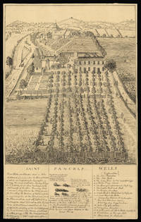
Saint Pancras Wells.: St Pancras
by [Anonymous]
- Used
- Condition
- Used
- Quantity Available
- 1
- Seller
-
London, United Kingdom
- Item Price
-
NZ$2,034.90NZ$32.13 shipping to USA
Show Details
Description:
[c.1750-1800].. 494 by 310mm (19.5 by 12.25 inches).. Drawing in ink with visible pencil guide lines. A drawing of Saint Pancras Wells. The area around what is now King's Cross was famous for its medicinal springs, and there were several wells in the area where Londoners could go to take the waters. The stones illustrated in the caption below the image were supposedly voided by people who had drunk the waters at St Pancras: they were also claimed as a cure for scrofula, leprosy and scurvy. The wells were named after the church, thought to be one of the oldest in England, which is visible in the background. The Wells grew into a destination for daytrippers as well as invalids: there were two pump rooms, tree-lined avenues for walking and a dining hall that could seat 200 people. A public house, the Adam and Eve, was built next to the church itself, visible in the print. This drawing, or one similar, was amongst those reproduced by the forger Peter Thompson. The British Museum holds two variants, but…
Read More Item Price
NZ$2,034.90
NZ$32.13
shipping to USA

More Photos
San Diego Zoo.: If you go down to the zoo today
by SCHULTHEIS, R.W
- Used
- Condition
- Used
- Quantity Available
- 1
- Seller
-
London, United Kingdom
- Item Price
-
NZ$535.50NZ$32.13 shipping to USA
Show Details
Description:
[Los Angeles],: Lowell Jones,, [c1940].. 420 by 560mm. (16.5 by 22 inches).. Large colour printed pictorial map on recto, and two smaller maps on verso, folding into self-wrappers: 'Recreational Map San Diego Zoo 25c', and address label. The main bird's-eye view map of the park shows it pioneering a cageless zoo design: divided into four mesas, housing reptiles, primates, 'Heavy Mammals', and hoofed animals. Between the mesas are canyons where the wild birds, 'bears, lions, and tigers', sea mammals, and cats, can be seen. The park is well served by no fewer than six restaurants and canteens, and an Animal Hospital. The two smaller additional maps are: a 'Pictorial Map of Balboa Park', with a key and "showing the location of San Diego Zoo in relation to the Exposition Area. Most of the building were originally constructed for the Panama-California Exposition held in 1915, and restored for the California Pacific International Exposition held in 1935-36"; and 'Downtown San Diego: Showing principal…
Read More Item Price
NZ$535.50
NZ$32.13
shipping to USA

San Francisco: A Frenchman's view of San Francisco
by MERYON, Charles
- Used
- Condition
- Used
- Quantity Available
- 1
- Seller
-
London, United Kingdom
- Item Price
-
NZ$12,852.00NZ$32.13 shipping to USA
Show Details
Description:
[Paris],: A. Delatre Imp. Rue Poissoniere 149,, 1856.. 335 by 1150mm. (13.25 by 45.25 inches).. Engraving, sheet 335 by 1150 mm, image 182 by 950 mm. A fine and exceptionally detailed view of San Francisco. The city was a point of interest in Europe after the gold rush of 1848, as people from within America and abroad rushed to California to seek their fortune. The population grew rapidly, forcing the city to expand haphazardly with narrow streets that survive to this day. The large title cartouche is supported by river gods who appear to be holding sieves, a reference to the activity that was making the city rich. Meryon, 1821-1868, was a French printmaker best known for etchings that romantically depict the life and mood of mid-19th-century Paris. He was commissioned by the prominent French banker François Louis Alfred Pioche to create this large-scale panoramic view of San Francisco. Pioche had made his fortune in San Francisco, but was back in Paris seeking investors for his rapidly growing…
Read More Item Price
NZ$12,852.00
NZ$32.13
shipping to USA

San Francisco: Oz by the Bay.: Helloooo Frisco: A Map for Friends of Dorothy
by ZELL-BREIER, Rob
- Used
- Condition
- Used
- Quantity Available
- 1
- Seller
-
London, United Kingdom
- Item Price
-
NZ$5,355.00NZ$32.13 shipping to USA
Show Details
Description:
[San Francisco],: City Graphics,, 1989.. 630 by 960mm. (24.75 by 37.75 inches).. Colour printed pictorial map. A fanciful pictorial map of San Francisco, here dubbed 'Oz by the Bay', featuring famous and prominent landmarks and private businesses. Each of the four corners of the map house a vignette of a principal character from the novel 'The Wonderful Wizard of Oz' (1900); clockwise, The Scarecrow, The Lion, The Tinman and The Good Witch. The protagonist, Dorothy, can be seen carrying her dog Toto in a basket while standing on the 'Yellow Brick Road', just below the title in the upper left hand corner of the map. The title is a reference to "Baghdad by the Bay," a nickname for the city coined in the 1940's by newspaper columnist Herb Caen, likely referencing the city's multicultural exoticism, though perhaps also an implication that the city's moral character resembled that of Babylon. The map spans the city's peninsula, with the Pacific Ocean to the west, the Golden Gate Bridge to the north and…
Read More Item Price
NZ$5,355.00
NZ$32.13
shipping to USA
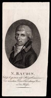
Schifs-Capitain Haupt Commandeur der neuesten Franz Ento-eckungs Reise in die Südsee.
by WESTERMAYER, C[onrad]; [after] [?Joseph] JAUFFRET
- Used
- Condition
- Used
- Quantity Available
- 1
- Seller
-
London, United Kingdom
- Item Price
-
NZ$642.60NZ$32.13 shipping to USA
Show Details
Description:
[Weimar,: Friedrich Justin Bertuch],, 1801.. 140 by 90mm. (5.5 by 3.5 inches).. Prints,""N. Baudin Nicolas-Thomas Baudin Stipple-engraved portrait. Nicolas-Thomas Baudin (1754-1803) was a French explorer, cartographer, naturalist and hydrographer, best known for his expedition to map the coast of Australia, then New Holland, which he undertook from 1800 to 1803. While moored at the British base in Sydney for supplies, he prepared a report for Napoleon on a potential French attack on the colony, and later named the coastline from Wilson's Promontory to Cape Leevwin, 'Terre Napoleon'. Baudin died of tuberculosis at Mauritius in 1803, aged only 49. Baudin's portrait featured in Volume Seven of 'Allgemeine Geographische Ephemeriden' published in 1801. The magazine's engraver, Conrad Westermayer, based the portrait on an earlier image of Baudin made the previous year by painter Joseph Jauffret. The portrait, which shows Baudin in a formal coat with embroidered collar, is accompanied by a caption in…
Read More Item Price
NZ$642.60
NZ$32.13
shipping to USA
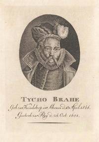
Schonen d.13 Aprl. 1546. Gestorb. zu Prag d.24.Oct.1601.
by [ANONYMOUS]
- Used
- Condition
- Used
- Quantity Available
- 1
- Seller
-
London, United Kingdom
- Item Price
-
NZ$342.72NZ$32.13 shipping to USA
Show Details
Description:
[Weimar,: Friedrich Justin Bertuch,, c1810].. 120 by 84mm. (4.75 by 3.25 inches).. Prints,""Tycho Brahe Geb. zu Kundstorp in Tycho Brahe Stipple-engraved portrait. Published in one issue of the German geographical journal, 'Allgemeine geographische Ephemeriden', was the present portrait of renowned Danish astronomer, Tycho Brahe (1546-1601), who laid the foundation for the later invention of the telescope. The portrait is based on an engraving by Jacques de Gheyn II, who had drawn Brahe at the end of the sixteenth century. Most of Gheyn's details are retained, including the high collar and the chain of the Order of the Elephant, but an elaborate feathered beret has also been added. Brahe's famous false nose, which was rumoured to be made of gold, is also prominent. The portrait, which originally showed Brahe's whole upper body, is cut to just a bust, beneath which his name and dates of birth and death are given, in German. Interestingly, a larger version of the present portrait was published by…
Read More Item Price
NZ$342.72
NZ$32.13
shipping to USA

Scotland: John Ainslie's Landmark Map of Scotland Drawn and Engrav'd from a Series of Angles and Astronomical Observations By John Ainslie Land Surveyor.
by AINSLIE, John
- Used
- Condition
- Used
- Quantity Available
- 1
- Seller
-
London, United Kingdom
- Item Price
-
NZ$10,710.00NZ$32.13 shipping to USA
Show Details
Description:
Edinburgh & London,: Printed & Sold by Thomas Brown; William Faden, Geographer to the King, Charing Cross, , Jan[uar]y 1st 1800.. 1770 by 1590mm. (69.75 by 62.5 inches).. Large engraved map on nine sheets, fine original full-wash hand-colour, dissected and mounted on linen, in four sections, insets of the Shetland and Orkney Isles, table of distances between towns, and heights of the 'Most Remarkable Hills', lower left. Ainslie's large and detailed map of Scotland. First published in 1789, this large and rare map would become the benchmark map of Scotland, until Aaron Arrowsmith's map of Scotland some 20 years later. The map is on the same scale (approx. 4 inches to 1 mile) as Dorret's map of 1750, however, it surpasses it in terms of clarity and accuracy; and for the first time the Great Glen from Inverness to Fort William is accurately depicted, as are many of the islands that make up the Western Isles. John Ainslie (1745-1828) was, without doubt, the outstanding Scottish cartographer of his…
Read More Item Price
NZ$10,710.00
NZ$32.13
shipping to USA

Scotland-Yard with part of the Banqueting-House: Scotland Yard
by ROOKER, Edward after SANDBY, Paul
- Used
- Condition
- Used
- Quantity Available
- 1
- Seller
-
London, United Kingdom
- Item Price
-
NZ$1,285.20NZ$32.13 shipping to USA
Show Details
Description:
London,: Publish'd According to Act of Parliament by Edwd. Rooker,, 1766.. 420 by 565mm. (16.5 by 22.25 inches).. Engraved print. A view of Banqueting House from Great Scotland Yard. From the series 'Six Views of London', by Edward Rooker. Rooker made the series of prints after drawings by the brothers Paul and Thomas Sandby. Adams 1983 58.4; BL 1881,0611.310.
Item Price
NZ$1,285.20
NZ$32.13
shipping to USA

Scotland: First edition of John Ainslie's Landmark Map of Scotland Drawn and Engrav'd from a Series of Angles and Astronomical Observations By John Ainslie Land Surveyor.
by AINSLIE, John
- Used
- Condition
- Used
- Quantity Available
- 1
- Seller
-
London, United Kingdom
- Item Price
-
NZ$12,852.00NZ$32.13 shipping to USA
Show Details
Description:
Edinburgh & London,: Printed & Sold by John & James Ainslie Booksellers & Stationers, St. Andrew's Street Newtown; William Faden, Geographer to the King, Charing Cross,, Jan 1st 1789.. 1770 by 1590mm. (69.75 by 62.5 inches).. Large engraved map on nine sheets, fine original full-wash hand-colour, dissected and mounted on linen, insets of the Shetland and Orkney Isles, table of distances between towns, and heights of the 'Most Remarkable Hills', lower left. Ainslie's large and detailed map of Scotland. First published in 1789, this large and rare map would become the benchmark map of Scotland, until Aaron Arrowsmith's map of Scotland some 20 years later. The map is on the same scale (approx. 4 inches to 1 mile) as Dorret's map of 1750, however, it surpasses it in terms of clarity and accuracy; and for the first time the Great Glen from Inverness to Fort William is accurately depicted, as are many of the islands that make up the Western Isles. John Ainslie (1745-1828) was, without doubt, the…
Read More Item Price
NZ$12,852.00
NZ$32.13
shipping to USA

The Sea of Marmara: The Sea of Marmara with Istanbul and the Bosphorus from surveys by Captn Manganari Russian Navy 1845, 48 and Captain Spratt and other Officers of the R.N.
by MANGANARI, Captain and SPRATT, Captain Thomas Abel Brimage
- Used
- Condition
- Used
- Quantity Available
- 1
- Seller
-
London, United Kingdom
- Item Price
-
NZ$3,213.00NZ$32.13 shipping to USA
Show Details
Description:
London,: The Admiralty,, 1859. Corrections to 1873. Minor corrections to 1877.. 650 by 1005mm (25.5 by 39.5 inches).. Engraved chart, 14 inset views, a few tears to lower margin and image skilfully repaired, some loss to imprint, reapired, old gule marks to verso. This rare chart of the Sea of Marmara was made at a critical time in the region's history. The Sea of Marmara, the Black Sea, and the Bosporus and Dardanelles straits are of central importance for the governance of Istanbul, and so the conflicts of the Ottoman Empire often rested on a detailed understanding of the waters. In the 1840s, joint Ottoman and Russian forces launched an expedition under Captain Manganari to complete the first systematical survey of the Black Sea using triangulation, which "deserves to be counted among the greatest contributions to the cartography of the sea" (King); the results of their work were published as an atlas, which "deserves to be counted among the greatest contributions to the cartography of the sea"…
Read More Item Price
NZ$3,213.00
NZ$32.13
shipping to USA

More Photos
The Seafarer's "Chart" of Hong Kong: A tourist map of Hong Kong This "chart" greets you with best wishes for a happy stay in this British Crown Colony.
by PORT WELFARE COMMITTEE
- Used
- Condition
- Used
- Quantity Available
- 1
- Seller
-
London, United Kingdom
- Item Price
-
NZ$535.50NZ$32.13 shipping to USA
Show Details
Description:
Hong Kong,: Port Welfare Committee,, [1950s].. 1010 by 680mm (39.75 by 26.75 inches).. Lithographed folding map, printed in blue and black, guide to the city on verso. A tourist map of Hong Kong produced by the Port Welfare Committee, an organisation set up to support seafarers in the city. On the back is a guide containing information on places of worship, public services and entertainment, with photographs of important buildings. On the map itself, dotted blue lines mark the paths of the ferries between the Kowloon and Hong Kong sides of the city, and the map key numbers and letters and place names are printed in blue as well. A blue square on the Hong Kong side outlines the area covered by the inset map at the top left hand corner. There is a photograph of the port on the upper cover.
Item Price
NZ$535.50
NZ$32.13
shipping to USA

Didn’t find what you’re looking for?
Try adding this search to your want list. Millions of books are added to our site everyday and when we find one that matches your search, we’ll send you an email. Best of all, it’s free.
Add to Want List

Are you a frequent reader or book collector?
Join the Bibliophile's Club and save 10% on every purchase, every day — up to $20 savings per order!

Social Responsibility
Did you know that since 2004, Biblio has used its profits to build 16 public libraries in rural villages of South America?
