Description:
[Strassburg,: Johann Schott,, 1513].. 425 by 600mm. (16.75 by 23.5 inches).. Double-page woodcut map. Waldeseemuller's strking map of Scandinavia. This work was based on the manuscript maps of Sanuto and Vesconte of c.1320, which were updated by Nicholaus Germanus in 1482 to include more cities and textual information. As noted by Ginsberg: "Waldseemuller's map . . .appeared in the supplmental section of modern maps. A faithful coy of the Ulm map published thirty-one years earlier, it too, is a woodcut. The title, however, differs from the Ulm 1486 edition by no longer referring to Prussia and Livonia. As on the 1482 map, Norway is shown as "norbegia." Most of the same cities are also included-- "asto" (oslo, 'begensis" (Bergen), Nodrosia (Niadros or Trondheim), and "Stauargnsis.". The lines to text in letterpress on the right-hand side that specify lines of parallel and lengths of days have been retained". Ginsberg, Scandinavia 5.
Search Results: Titles starting with T from Daniel Crouch Rare Books Ltd
You searched for:
- Bookseller inventory: Daniel Crouch Rare Books Ltd (titles starting with T)
- Bookseller: Daniel Crouch Rare Books Ltd
Results 1 - 20 of 38

Tabula Moderna Norbegie et Gottie.: Waldeseemuller's map of Scandinavia
by WALDESEEMULLER
- Used
- Condition
- Used
- Quantity Available
- 1
- Seller
-
London, United Kingdom
- Item Price
-
NZ$17,130.40NZ$32.12 shipping to USA
Show Details
Item Price
NZ$17,130.40
NZ$32.12
shipping to USA

Tabula Terre Nove.: The first map devoted to America to appear in an atlas
by PTOLEMAEUS, Claudius and Martin WALDSEEMULLER
- Used
- first
- Condition
- Used
- Quantity Available
- 1
- Seller
-
London, United Kingdom
- Item Price
-
NZ$107,065.00NZ$32.12 shipping to USA
Show Details
Description:
[Strassburg,: Johann Schott,, 1513].. 400 by 460mm (15.75 by 18 inches).. Double-page woodcut map of the world. Waldseemuller's map of the New World shows the Atlantic coast of the Americas from latitudes 35 degrees south to 55 degrees north, including 20 place-names on the North American coastline. An apparent Gulf of Mexico, the Florida peninsula, Cuba as Isabella and Hispaniola, and across the Atlantic portions of the British Isles, Spain and Portugal and Africa are visible. First edition, published in Schott's edition of Ptolemy's 'Geographia', Strassburg, 1513, the first modern atlas, prepared by Martin Waldseemuller using the translation of Mathias Ringmann, and one of the most important editions of Ptolemy, containing many new regional maps: twenty new maps based on contemporary knowledge, "unlike many of the alleged 'new' maps produced by earlier editors, [they] contained a great deal of new information, and in nearly every case they were decided improvements over anything that had been…
Read More Item Price
NZ$107,065.00
NZ$32.12
shipping to USA
![Taken from Mr. de Fer's Map of Asia, Shewing their Cheif [sic] Divisions, Cities, Towns, Ports,...](https://d3525k1ryd2155.cloudfront.net/h/129/598/1456598129.0.m.jpg)
Taken from Mr. de Fer's Map of Asia, Shewing their Cheif [sic] Divisions, Cities, Towns, Ports, rivers, Mountains, &c. Dedicated to His Highness William Duke of Gloucester.
by WELLS, Edward
- Used
- Condition
- Used
- Quantity Available
- 1
- Seller
-
London, United Kingdom
- Item Price
-
NZ$792.28NZ$32.12 shipping to USA
Show Details
Description:
[London,: T.W. for J. Walthoe, R. Wilkin, J. and J. Bonwicke, S. Birt, T. Ward and E. Wicksteed, , from 1700].. 420 by 580mm. (16.5 by 22.75 inches).. Maps,""A New Map of the East Indies, Dedicated to the young and sickly Duke of Gloucester Engraved map with contemporary hand-colour in outline. Published in Wells's 'A New Sett of Maps of Antient and Present Geography', over time by subscription. All the maps in the series were dedicated to the young and sickly Duke of Gloucester, son of Queen Anne, who died at the end of July in 1700, just after Williamsburg in Virginia had been named for him. The plates were prepared by some of the most accomplished engravers in Oxford including Michael Burghers, who worked for Moses Pitt on his atlas; R. Spofforth, Sutton Nicholls, Edward Smith, Benjamin Cole, and John Moxon. Based on the lower right-hand portion of Nicolas de Fer's 'L'Asie Dresse selon les dernieres Relations et Suivant les Nouvelles Decouvertes', first published in 1700, but reissued for…
Read More Item Price
NZ$792.28
NZ$32.12
shipping to USA

Taprobana.: The only map of Sri Lanka published by the Lafreri school
by [?LAFRERI, Antonio]
- Used
- Condition
- Used
- Quantity Available
- 1
- Seller
-
London, United Kingdom
- Item Price
-
NZ$6,423.90NZ$32.12 shipping to USA
Show Details
Description:
[Rome,: A. Lafreri,, c1570].. 264 by 200mm (10.5 by 7.75 inches).. Engraved map, watermark of a letter 'M' under star in shield. A striking map of Sri Lanka attributed to Antonio Lafreri. The map is typical of the Lafreri School with Venetian galleys on the stippled sea, cities and towns represented as bird's-eye views, and hills and trees populating the interior. Although the map is anonymous, the work has been attributed, by Destombes, to the Rome publisher Antonio Lafreri, who lists a map of Sri Lanka in his catalogue - item no. 75. La Barroni suggests that the map is a copy of an earlier map, published in Venice, however, there is no substantive evidence for this. The map would later be acquired by Claudio Duchetti, and then by Giacomo Gherardi, who advises it in his catalogue in 1598 (No.175 "isola tapproban"). The plate would then be purchased by Giovanni Orlandi, and finally by Hendrik van Schoel. Bifolco TAV. 86; cf. Woodward 316-318.
Item Price
NZ$6,423.90
NZ$32.12
shipping to USA

[The Cock Pit]; Rules of cocking; [and] Admission ticket for a cock pit.
by HOGARTH, William, """"Mr Ardesoy""""
- Used
- Hardcover
- Condition
- Used
- Binding
- Hardcover
- Quantity Available
- 1
- Seller
-
London, United Kingdom
- Item Price
-
NZ$34,260.80NZ$32.12 shipping to USA
Show Details
Description:
The City of London,: The Pit. St James' Park,, May 4 1756.. 410 by 575mm (16.25 by 22.75 inches).. Prints,""[A trio of items relating to The Royal Cock Pit]: Cocking 1. [The Cock Pit] Etching with engraved lettering. Dimensions: Sheet: 410 by 575mm; Image: 308 by 370mm. 2. Rules and Order of Cocking Manuscript on vellum, red ink, triptych illumination depicting three pairs of cocks in fighting garb above manuscript rules, set within red ink border. Dimensions: 275 by 300mm. 3. Admission ticket for a cock pit, c1795. Silver, Dimensions: Height: 37mm. The Royal Cockpit was built in the late seventeenth century on the south side of St James's Park, off Birdcage Walk. It was demolished in 1816. Cockfighting was enjoyed by all levels of society. Hogarth shows the blind Lord Albemarle Bertie (c1720-1765), brother of the Duke of Ancaster, in a crowd that includes a butcher, a chimney-sweep, a sow gelder, a black footman, a coachman and a jockey; women were not admitted. James Boswell, a young Scot in…
Read More Item Price
NZ$34,260.80
NZ$32.12
shipping to USA
![[The Hereford Mappa Mundi] Hanc quam videtis terrarum orbis tabulam](https://d3525k1ryd2155.cloudfront.net/h/106/507/1391507106.0.m.jpg)
[The Hereford Mappa Mundi] Hanc quam videtis terrarum orbis tabulam: The Hereford Mappa Mundi descripsit delineavitque Ricardus de Haldingham sive de Bello dictus. A.S. circa MCCC
- Used
- Hardcover
- Condition
- Used
- Binding
- Hardcover
- Quantity Available
- 1
- Seller
-
London, United Kingdom
- Item Price
-
NZ$42,826.00NZ$32.12 shipping to USA
Show Details
Description:
London,: Edward Stanford, Charing Cross,, 1872.. 1700 by 1430mm. (67 by 56.25 inches).. Chromolithograph map, dissected and mounted on linen, some minor loss at folds. Rare one to one facsimile of the largest extant medieval mappa mundi. Mappa Mundi Medieval world maps (or mappae mundi) were not designed with geographical accuracy in mind, but to illustrate Judeo-Christian beliefs and Classical geographical concepts. They ranged from the purely diagrammatic climate zone maps based on the work of Macrobius; and the "T-O" maps designed to illustrate the three land masses (Europe, Asia, and Afica) of the world as it was known from classical texts; to the often monumental maps, such as Hereford's 'Mappa Mundi' (the present facsimile), which although employing the general layout of a "T-O", provided considerably more geographical content, together with illustrations of biblical events, fabled beasts, and peoples. What such maps have in common is their circular form. This not only reinforced in the…
Read More Item Price
NZ$42,826.00
NZ$32.12
shipping to USA

[The latest edition of the map of Hong Kong in full detail;: Large plan of 1930s Hong Kong showing the cyclone scale with a map of Kowloon; for the use of all purposes].
by [SANXING PRESS]
- Used
- Condition
- Used
- Quantity Available
- 1
- Seller
-
London, United Kingdom
- Item Price
-
NZ$10,706.50NZ$32.12 shipping to USA
Show Details
Description:
[Guangzhou,: Sanxing Press,, c1931].. 355 by 780mm (14 by 30.75 inches).. Chromolithograph plan, inset maps of Kowloon, Guangzhou, Hong Kong and the New Territories, some strengthening to folds, a few old repairs. Fine and detailed plan of Victoria, Hong Kong. The plan stretches west to east from Belcher's Bay to North Point. All prominent public and private buildings are named and marked, as are tramways, streets, rivers, public telephone boxes, tracks, and the Mount Parker cable car. The Mount Parker Cable Car connected Quarry Gap (between Mount Parker and Mount Butler) and Quarry Bay near present day Yau Man Street. It was built to provide a means of transport for employees of the Swire Group between the staff quarters uphill, and Taikoo Dockyard and Taikoo Sugar Refinery downhill. It operated between 1892 and 1932. To the lower right is a plan of Guangzhou. To the left is an inset plan of the New Territories marking lighthouses, towns, villages, railways, mountains, and borders. Next to this…
Read More Item Price
NZ$10,706.50
NZ$32.12
shipping to USA
More Photos
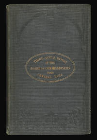
Third Annual Report of the Board of Commissioners of the Central Park.: Central Park New York
- Used
- Hardcover
- first
- Condition
- Used
- Binding
- Hardcover
- Quantity Available
- 1
- Seller
-
London, United Kingdom
- Item Price
-
NZ$4,282.60NZ$32.12 shipping to USA
Show Details
Description:
New York,: WM. C. Bryant & Co., Printers, 41 Nassau Street, Corner Liberty,, 1860.. First edition, octavo (230 by 145mm), publisher's gilt-lettered and blindstamped cloth, 72 pages, illustrated with a frontispiece, 8 full-page plates, 3 folding plates, and a large coloured folding map of Central Park, showing the progress of the work up to January 1st 1860, as laid out by Frederick Law Olmsted and Calvert Vaux, small tear to map, title page detached. The purpose of the report is to describe the progress of Central Park, combined with additional information including a list of board members, notes from the treasury, descriptions of continuing construction, comparisons to other New York City parks and explanations on the park's drainage system. Highlighted should be the variety of style in several plates. The non-coloured, and sepia lithographs of distinctive bridges in the Central Park are depicted from several angles, offering a romanticised, peaceful view with well-dressed couples strolling or…
Read More Item Price
NZ$4,282.60
NZ$32.12
shipping to USA

This Orient Isle: This Orient Isle Elizabethan England and the Islamic World.
by BROTTON, Jerry
- Used
- Hardcover
- Signed
- first
- Condition
- Used
- Binding
- Hardcover
- Quantity Available
- 1
- Seller
-
London, United Kingdom
- Item Price
-
NZ$42.83NZ$32.12 shipping to USA
Show Details
Description:
London, : Allen Lane,, 2016.. Hardback, 384 pages, iscribed by the author. In 1570, when it became clear she would never be gathered into the Catholic fold, Elizabeth I was excommunicated by the Pope. On the principle that 'my enemy's enemy is my friend', this marked the beginning of an extraordinary English alignment with the Muslim powers who were fighting Catholic Spain in the Mediterranean, and of cultural, economic and political exchanges with the Islamic world of a depth not again experienced until the modern age. England signed treaties with the Ottoman Porte, received ambassadors from the kings of Morocco and shipped munitions to Marrakesh. By the late 1580s hundreds, perhaps thousands, of Elizabethan merchants, diplomats, sailors, artisans and privateers were plying their trade from Morocco to Persia. These included the resourceful mercer Anthony Jenkinson who met both Süleyman the Magnificent and the Persian Shah Tahmasp in the 1560s, William Harborne, the Norfolk merchant who became the…
Read More Item Price
NZ$42.83
NZ$32.12
shipping to USA

This Plan of the Harbour, Town and Forts of Porto Bello...: The greatest British success in the War of Jenkin's Ear
by DURELL, Philip
- Used
- Condition
- Used
- Quantity Available
- 1
- Seller
-
London, United Kingdom
- Item Price
-
NZ$7,494.55NZ$32.12 shipping to USA
Show Details
Description:
London,: S. Harding,, 1740.. 420 by 585mm. (16.5 by 23 inches).. Engraved map with contemporary full-wash colour. Philip Durrell (1707-1766) was a British naval officer. He rose to the rank of Vice Admiral over a stellar career, participating in important naval victories including the Siege of Louisbourg in 1745, when a British fleet captured the city in the War of the Austrian Succession. This map was drawn when he was still a Lieutenant, serving under Admiral Vernon during his command of Jamaica during the War. The capture of Porto Bello occurred in the early stages of the War of Jenkin's Ear, which turned into the War of the Austrian Succession. The War of Jenkin's Ear began as the British fought the Spanish for the right to continue with slave contracts in Spanish America, developing into the War of the Austrian Succession as European powers ostensibly challenged Maria Theresa's claim to the Hapsburg throne, but in reality attempted to subsume Austrian possessions in Europe. Porto…
Read More Item Price
NZ$7,494.55
NZ$32.12
shipping to USA

This Plate of St. Georges Parish, Hanover Square.: Rare plan of St. Georges Parish, Hanover Square With the Views of the Church and Chapels of Ease from the Original Survey of the late Mr Morris is most humbly Dedicated to the Right Hon.ble the Earl Lichfield & Sr Charles Tynte the Church Wardens and the
by BICKHAM, G[eorge]
- Used
- Condition
- Used
- Quantity Available
- 1
- Seller
-
London, United Kingdom
- Item Price
-
NZ$10,706.50NZ$32.12 shipping to USA
Show Details
Description:
[London],: Published according to Act of Parliament, & Sold in May's Buildings by G. Bickham Engraver,, March the 24th, 1761.. 545 by 470mm (21.5 by 18.5 inches).. Broadsheet engraved plan, elaborate border with seven views of the parish's churches and chapels. The plan bears a great deal of rococo decoration which not only encloses much of the map, but also the seven views of the parish churches and chapels of ease. Above the plan is a view of St. George's Hanover Square; to the left views of Berkeley Chapel, Audley Street Chapel, and Chelsea Chapel, and to the right Knightsbridge Chapel, Conduit Street Chapel, and Mayfair Chapel. Below is a key together with a scale-bar, the imprint, and a dedication. St. George's Church was built in 1721-4 to the designs of John James and at a cost of £10,000, as one of fifty churches projected by Queen Anne's Act of 1711. The parish for the new church was carved out of St. Martin-in-the-Fields and covered what are now the areas of Mayfair, Belgravia and…
Read More Item Price
NZ$10,706.50
NZ$32.12
shipping to USA

This Porcineograph.: America Hams it Up This Good Cheer Souvenir.
by BAKER, W[illiam] E[merson].
- Used
- Condition
- Used
- Quantity Available
- 1
- Seller
-
London, United Kingdom
- Item Price
-
NZ$25,695.60NZ$32.12 shipping to USA
Show Details
Description:
Boston,: W. E. B[aker], 13 West Street, Boston, Mass.,, 1876.. Multi-stone lithograph. This map depicts the United States as a pig, with the snout at Maine and two legs represented by the peninsulas of Florida and Baja. A third leg rests on Cuba, drawn in the shape of a sausage, and the fourth on the Sandwich Islands, drawn-naturally-as a cluster of sandwiches. The "GEHOGRAPHY," as the author refers to it, is surrounded by the seals of the states and the names of their favoured pork-based dishes. Two vignettes at lower left and right illustrate events-both involving pigsthat resulting in litigation or legislation that changed the course of American history. The map was designed by one William Emerson Baker (1828-1888), who intended it to serve simultaneously as a keepsake, promotional piece and symbol of national unity: "whose successful Grover & Baker Sewing Machine Company produced accessibly-priced units for home use, retired in 1868 at the age of forty. He moved to a large farm in Needham,…
Read More Item Price
NZ$25,695.60
NZ$32.12
shipping to USA
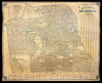
Thomas Bros' Map of the City & County of San Francisco.: San Francisco - risen from the ashes
by THOMAS, George Coupland, O'SHAUGHNESSY, Michael Maurice.
- Used
- Condition
- Used
- Quantity Available
- 1
- Seller
-
London, United Kingdom
- Item Price
-
NZ$32,119.50NZ$32.12 shipping to USA
Show Details
Description:
San Francisco, Oakland and Los Angeles,: Compiled & Published by Thomas Bros. Map Publishers & General Draftsmen,, 1926. 1676 by 2083mm. (66 by 82 inches; 5.5 by 7 feet).. Lithographed wall map, printed in blue, over-printed in red, blue and green wash in outline to coastline and the park areas respectively, laid down on linen as issued A monumental map of San Francisco, at the height of its post-fire pre-depression era development, the vision of the chief engineer Michael Maurice O'Shaughnessy (1864-1934), who modernised the infrastructure of San Francisco and who is revered as one of the most important civil engineers in American history. After the devastating earthquake and fire of 1906, San Francisco underwent an intense period of reconstruction and development, which culminated in the city as the Thomas Brothers' map shows it. A year later, in 1927, construction began on San Francisco airport, on Mills Fields, 13 miles south in San Mateo County, making it a truly international city. The city is…
Read More Item Price
NZ$32,119.50
NZ$32.12
shipping to USA

A Tigress.: George Stubbs's Tigress Painted by Geo Stubbs, Engraved by Rob Laurie, From a Capital Picture by Geo Stubbs in the possession of his grace the Duke of Marlborough.
by STUBBS, G[eorge], [Engraved by] Robert LAURIE
- Used
- Hardcover
- Condition
- Used
- Binding
- Hardcover
- Quantity Available
- 1
- Seller
-
London, United Kingdom
- Item Price
-
NZ$32,119.50NZ$32.12 shipping to USA
Show Details
Description:
London,: Republished by Robt. Laurie & Jas Whittle No 53 Fleet St, London, (Successors to the late Mr Robert Sayer)., 12 Nov 1800.. Mezzotint. Stubbs's striking Tigress. The present example is a copy of Dixon's celebrated print first published in 1772, taken from a life size painting at Blenheim Palace, and was "the most highly praised print after Stubbs in its day". The plate was reviewed in 'The Monthly Magazine' in February 1802: "... a print of a tiger, from Stubbs, which, after being many years out of print, is re-engraved and re-published by Laurie and Whittle. The first copy engraven from this picture was by the celebrated artist, Mr. John Dixon, and the writer of this article is inclined to think, that, without any exception, it was the finest mezzotinto that ever was engraved. The plate was destroyed by fire. The present copy... [is] engraved in a very respectable style". George Stubbs (1724-1806) was one of the greatest of all British animal painters. Little is known about his formative…
Read More Item Price
NZ$32,119.50
NZ$32.12
shipping to USA

To Captain H.E.R. Baker of H.M.S. Jupiter and Commodore of the E.I. Fleet. This Chart of a new Passage tho' which he conducted the Fleet in August 1807: Manuscript chart of the track of H.M.S. Jupiter for the year 1807 is a Proof of his Anxiety for its quick arrival in India and is a mark of his esteem of his most obedt. and faithful, humble Servt. J.A. Camberledge.
by CAMBERLEDGE, J.A.
- Used
- Hardcover
- Condition
- Used
- Binding
- Hardcover
- Quantity Available
- 1
- Seller
-
London, United Kingdom
- Item Price
-
NZ$2,569.56NZ$32.12 shipping to USA
Show Details
Description:
1807. 450 by 590mm. (17.75 by 23.25 inches).. Manuscript chart, with the tracks of HC Surrey, and HMS Jupiters convoy of 11 East Indiamen, naval ledger to verso, minor worming. The chart depicts the track of H.M.S. Jupiter passing Madagascar in the year 1807. As the chart states: 'The track of His Majesty's Ship Jupiter Commodore Baker in 1807 having under his Convoy eleven Indiamen who being prevented going to the north by constant Northerly Winds on getting the SE Trade carried the Fleet thro' this passage without meeting any Island or Shaol' As is stated above she was acting as escort for eleven East Indiamen. The continuing war with France had left many of the convoys to India, the East Indies, and China vulnerable to attack by French ships. As a reaction to this threat the British began to sail in convoy and, as here, with a military escort. H.M.S. Jupiter was a 50 gun fourth rate ship-of-the-line launched in 1778. She was wrecked on the 10th December 1808 - just three months after her…
Read More Item Price
NZ$2,569.56
NZ$32.12
shipping to USA

To George Washington President of the United States of America this Magnetic Atlas or Variation Chart is humbly inscribed by John Churchman.: A presentation copy of the last gasp for Edmund Halley's theory for the determination of longitude by magnetic declination [together with:] An Explanation of the Magnetic Atlas, or Variation Chart, hereunto annexed; projected on a plan entirely new.
by CHURCHMAN, John
- Used
- Condition
- Used
- Quantity Available
- 1
- Seller
-
London, United Kingdom
- Item Price
-
NZ$107,065.00NZ$32.12 shipping to USA
Show Details
Description:
Philadelphia, , 1790.. 609 by 609mm. (24 by 24 inches).. Engraving, with original wash colour, a few creases flattened, some areas of restoration to upper and lower sheet edges not affecting printed image, [together with:] 8vo. x, [3], 14-46, 5, [1]pp., 2 folding charts, minor foxing to text, faint damp stain affecting portion of first four leaves, and minor chips to edges. The Mapmaker John Churchman (1753-1805) was an American mathematician, surveyor, mapmaker, and self-propagandist who held the official post of surveyor for Chester, Delaware and parts of Berks and Lancaster Counties, Pennsylvania. He first came to prominence for his 'Map of the Peninsula between Delaware & Chesapeak Bays' (1778). Some time in the mid-1780s Churchman became consumed by the problem of finding longitude at sea, which had challenged navigators for centuries. The search was given impetus in 1714 by the creation in London of the Board of Longitude, charged with assessing proposals and empowered to award a staggering…
Read More Item Price
NZ$107,065.00
NZ$32.12
shipping to USA
![To Martin Folkes Esq[ui]r[e] President of the Royal Society: This Plan of the Cities of London](https://d3525k1ryd2155.cloudfront.net/h/273/910/1162910273.0.m.jpg)
To Martin Folkes Esq[ui]r[e] President of the Royal Society: This Plan of the Cities of London: An unrecorded state with erasures on the plate with the Contiguous Buildings; is humbly Inscribed by his most Humble Servants John Pine and John Tinney.
by ROCQUE, John
- Used
- Condition
- Used
- Quantity Available
- 1
- Seller
-
London, United Kingdom
- Item Price
-
NZ$9,635.85NZ$32.12 shipping to USA
Show Details
Description:
London,: Published according to Act of Parliament, Sold by the Proprietors John Bowles in Cornhill, Carington Bowles in St. Pauls Church Yard, Robert Sayer in Fleet Street, and Thomas Jefferys at the Corner of St. Martins Lane in the Strand,, 20th May, 1763.. 512 by 953mm (20.25 by 37.5 inches).. Engraved plan. The text below the plan states that the map was taken from Rocque's great survey of the city, the surveying of which was begun in March of 1737, and took nine years for Rocque to complete. The map is dedicated by John Pine and John Tinney to the president of the Royal Society, Martin Folkes. John Pine, who described himself as Bluemantel Pursuivant at Arms & Engraver of Seals, etc. to His Majesty, engraved the original 24-sheet map and the reduction. John Tinney was responsible along with Pine for the map's publication. The text below, which is dated 1742, states how accurate the 24-sheet map was and what lengths they went to: "they have not thought much of the trouble of drawing the main Plan…
Read More Item Price
NZ$9,635.85
NZ$32.12
shipping to USA
![To The Hon[oura]ble the Court Directors of the East India Company This Improved Map of India](https://d3525k1ryd2155.cloudfront.net/h/913/468/1286468913.0.m.jpg)
To The Hon[oura]ble the Court Directors of the East India Company This Improved Map of India: The largest map of India produced before the trigonometrical survey Compiled from all the Latest & most Authentic Materials Is Respectfully Dedicated by their most Obedient & most Humble Servant A. Arrowsmith.
by ARROWSMITH, Aaron
- Used
- Condition
- Used
- Quantity Available
- 1
- Seller
-
London, United Kingdom
- Item Price
-
NZ$21,413.00NZ$32.12 shipping to USA
Show Details
Description:
London,: Published by A. Arrowsmith, Hydrographer to his Majesty, No. 10 Soho Square,, 2nd January, 1816.. 2400 by 2670mm (94.5 by 105 inches).. Large engraved map, on nine sheets, original outline hand-colour, some off-setting. Arrowsmith's monumental wall map of India on nine sheets. With the growing influence of the British in India at the end of the eighteenth century, the need for an up-to-date general map of the sub-continent grew. The first Governor-General, Warren Hastings, employed Major Rennell who, in 1779, published his famous Bengal Atlas, followed up in 1788 by his map of India. The map itself was based upon D'Anville's map of 1752, though enriched by much new material, supplied by the numerous "route surveys" carried out by the army. As these "route surveys" began to become more numerous and accurate the need for a new general map of India soon became apparent. In 1816 Aaron Arrowsmith published his Map of India in nine sheets, on a scale of sixteen miles to an inch, which was the…
Read More Item Price
NZ$21,413.00
NZ$32.12
shipping to USA

To the Chancellor, Master and Scholars of the University and the Mayor, Aldermen, & Citizens of the city of Oxford, This Plan from Actual Survey is most respectfully inscribed by Robert Syer Hoggar, Assoc. Inst. C.E. 1850: The most important nineteenth century plan of the city of Oxford
by HOGGAR, Robert Syer
- Used
- Condition
- Used
- Quantity Available
- 1
- Seller
-
London, United Kingdom
- Item Price
-
NZ$7,494.55NZ$32.12 shipping to USA
Show Details
Description:
Oxford,, 1850.. 1565 by 1220mm. (61.5 by 48 inches).. Engraved map on four sheets, dissected and mounted on linen, on rollers. The most important nineteenth-century plan of the city of Oxford, forming a link between the earlier surveys carried out by Isaac Taylor in 1751, (with the later revision by William Faden in 1789), and Richard Davis in 1797 (engraved by John Cary and forming part of Davis's survey of Oxfordshire) and the large-scale maps and plans of the Ordnance Survey which surveyed Oxfordshire in 1876. Such plans, together with their smaller-scale successors that appeared in countless 'Oxford Guide-Books', have provided the definitive basis for most of the plans, street maps and tourist guides that proliferated throughout the nineteenth century. It includes the new working-class suburbs of St. Ebbs, St. Thomas's and Jericho, of which the first two were blighted by the building of the gasworks in 1818 following the passing of an Act in that year which allowed for the manufacture of…
Read More Item Price
NZ$7,494.55
NZ$32.12
shipping to USA

To the Right Honourable and Right Reverend William Howley, D.D. Lord Bishop of London and the Right Reverend the Dean and Chapter;: St Paul's Cathedral This North West View of the Cathedral Church of Saint Paul, is by Permission most humbly dedicated, by their Lordship's much obliged and devoted servant, John Buckler.
by LEWIS, G[eorge Robert] [after] BUCKLER, J[ohn]
- Used
- Condition
- Used
- Quantity Available
- 1
- Seller
-
London, United Kingdom
- Item Price
-
NZ$3,211.95NZ$32.12 shipping to USA
Show Details
Description:
Surrey,: Published by J. Buckler, Bermondsey,, 1814.. Image: 450 by 625mm (17.75 by 24.5 inches). Sheet: 540 by 710mm (21.25 by 28 inches).. Etching with aquatint. A view of the west front of St Paul's Cathedral. John Buckler (1770-1851) was an estate manager and bailiff for Magdalene College, Oxford. He occasionally practised as an architect, designing Halkyn Castle, but was a much more prolific producer of architectural engravings. Around 1800 he began a series which was intended to encompass all the cathedrals in the country: this print of St Paul's was produced near the completion of the series, which also included many college and parish churches. He was helped by his son John Chessel Buckler (1793-1894), who later published the 'Views of the Cathedral Churches of England and Wales', using his own text and his father's engravings. BL Maps K.Top.23.35.t; BM 1890,1013.106.
Item Price
NZ$3,211.95
NZ$32.12
shipping to USA

Didn’t find what you’re looking for?
Try adding this search to your want list. Millions of books are added to our site everyday and when we find one that matches your search, we’ll send you an email. Best of all, it’s free.
Add to Want List

Are you a frequent reader or book collector?
Join the Bibliophile's Club and save 10% on every purchase, every day — up to $20 savings per order!

Social Responsibility
Did you know that since 2004, Biblio has used its profits to build 16 public libraries in rural villages of South America?
