
Click for full-size.
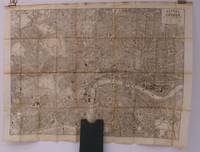
Bacon's New Map of Central London. Divided into Half Mile Squares and Circles. Scale: Four Inches to the Mile. A RARE SURVIVAL
by BACON G.W
- Used
- Hardcover
- Condition
- See description
- Seller
-
Thakeham, West Sussex, United Kingdom
Payment Methods Accepted
About This Item
Bacon,, [c.1890]. Folding engraved map printed on fine ivory linen, size: 21 x 28 ins (approx. 53.0 x 71.0 cms) folding in 36 panels to 6 x 3 ins (approx. 15.o x 7.5 cms), printed surface very lightly browned (rather more heavily so along central fold), a few locations marked with red ink ; original green cloth slip-case framed in blind and lettered in black 'Flexible Map of London' with deckled thumb-hole, a very good, bright copy. Covers the area from Islington (north) to Oval (south); Notting Hill (west) to Stepney (east). IN THIS CONDITION A RARE SURVIVAL. Hyde, 'Printed Maps of Victorian London', no. 201.
Reviews
(Log in or Create an Account first!)
Details
- Bookseller
- Island Books
 (GB)
(GB)
- Bookseller's Inventory #
- 28097
- Title
- Bacon's New Map of Central London. Divided into Half Mile Squares and Circles. Scale: Four Inches to the Mile. A RARE SURVIVAL
- Author
- BACON G.W
- Book Condition
- Used
- Binding
- Hardcover
- Publisher
- Bacon,
- Date Published
- [c.1890]
- Keywords
- topography, london, maps, g.w. bacon, g.w. bacon, topography, maps, bacon's, new, map, central, london
Terms of Sale
Island Books
Returns within 10 days (please advise first)
About the Seller
Island Books
Biblio member since 2004
Thakeham, West Sussex
About Island Books
Fine and Rare Books at the foot of the South Downs
Glossary
Some terminology that may be used in this description includes:

How to tell if a signature is genuine
Author's signatures can undoubtedly increase the value of a rare book or first edition. The more scarce the book is, the more an autograph adds to its value. But how to tell if the signature is real? Find out how you can avoid common pitfalls in identifying an author's signature.

Collecting BiblioMysteries
Want to get meta? Bibliomysteries are mystery stories which deal in some significant way with books and the world associated with books. Browse this fascinating subgenre of mystery novels.
