Click for full-size.

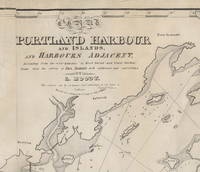
Chart of Portland Harbour and Islands, and Harbours Adjacent, Extending from the River Kennebec to Wood Island and Winter Harbour, Drawn from the Survey of Des Barres with Additions and Corrections by L. Moody.
by [Casco Bay, Maine] [Nautical Chart.] Moody, Lemuel
- Used
- Condition
- See description
- Seller
-
Scarborough, Maine, United States
Payment Methods Accepted
About This Item
Important Early Chart of Portland (Maine) Harbor
Lemuel Moody (1767-1846) was an enterprising sea captain and nautical entrepreneur in Portland, Maine. Realizing "the great necessity of a correct Chart of Portland Harbour and the dangerous Rocks near Cape Elizabeth, also of Winter Harbour and the numerous islands in Casco Bay," Moody decided to produce such a chart. By 1825, the Atlantic Neptune charts that included this area were more than 50 years old and in need of updating. Moody took advantage of the opportunity and produced this chart, using the Atlantic Neptune charts as the foundation. In a notation on the original agreement for producing the chart, Moody states that "I did the whole of the survey." This impressive chart of Casco Bay was his sole cartographic undertaking.
The chart covers the area from Saco Bay to Seguin Island. A large inset at the upper left focuses on the immediate area around Portland harbor, including a detailed layout of streets and wharves. Small drawings of several sailing ships decorate the chart. Of particular interest is one sailing vessel being towed by a steam-belching vessel southeast of Small Point, an early record of steam-powered ships in Maine waters.
One of the prominent landmarks that Moody included on the chart is the Portland Observatory, an 86' high tower that still stands atop Portland's Munjoy Hill. The Observatory, one of Moody's entrepreneurial undertakings, was built in 1807 and served as a marine signaling tower. Using a telescope from the tower and a flag-based signaling system, Moody would – for an annual fee – alert ship owners of the arrival of their vessels well in advance of their arrival in the harbor.
The chart went through at least five states, of which this is the second. The fortuitous survival of Moody's business records and the known construction dates of certain marine landmarks make it possible to identify the dates and production run of the various states of the chart with a fair degree of specificity. While all the charts produced include the initial publication date of 1825 in the title, later states were known to have been printed in 1828, 1832, 1838 and 1857. The initial 1825/6 printing was 191 charts. For this second state, only 49 charts were struck from the plates.
The second state is distinguished by the addition of two light towers that were constructed in Cape Elizabeth in 1828. (Known now, appropriately enough, as "Two Lights," the two structures still stand, though one has been decommissioned as a navigation aid.) The updates to the copperplate and printing of this state were by Andrew Allen of Boston.
Moody's chart is very uncommon in any of its states. OCLC identifies three institutional holders as of September, 2021: State Library of Massachusetts, Osher Map Library and Boston Public Library. Additional examples are held at the Maine Historical Society, Library of Congress, Yale and at least one private collector. No examples of the chart were identified in the Antique Map Price Record during its run from 1983 to 2011.
A very attractive example of an important and scarce early Maine chart.
Reference: Phillips, A List of Maps of the United States: p. 717 (Mistakenly titled as Map of Portland Harbour and Islands…)
Acknowledgment: I am indebted to Ms. Frances Pollitt, formerly of the Maine Historical Society, for sharing her research on the dating and production of Moody's chart.
Condition: Lined on reverse, mending several tears. Very minor recreation of image loss and restoration of blank margin areas.[ICN 7690.3.]
Reviews
(Log in or Create an Account first!)
Details
- Seller
- BICKERSTAFF'S BOOKS, MAPS &C.
 (US)
(US)
- Seller's Inventory #
- 3754
- Title
- Chart of Portland Harbour and Islands, and Harbours Adjacent, Extending from the River Kennebec to Wood Island and Winter Harbour, Drawn from the Survey of Des Barres with Additions and Corrections by L. Moody.
- Author
- [Casco Bay, Maine] [Nautical Chart.] Moody, Lemuel
- Book Condition
- Used
- Quantity Available
- 1
- Publisher
- [Lemuel Moody.] .] Engd by D. G. Johnson. Entered According to Act of Congress July 13th, 1825. [but 1828.]
- Place of Publication
- [Portland, Maine]
- Date Published
- [1828.]
- Size
- About 26 x 48.”
- Weight
- 0.00 lbs
Terms of Sale
BICKERSTAFF'S BOOKS, MAPS &C.
30 day return guarantee, with full refund including original shipping costs for up to 30 days after delivery if an item arrives misdescribed or damaged.
About the Seller
BICKERSTAFF'S BOOKS, MAPS &C.
Biblio member since 2020
Scarborough, Maine
About BICKERSTAFF'S BOOKS, MAPS &C.
Since 1980 we have had the pleasure of offering interesting American books, maps and ephemera to discerning collectors and institutional clients. We would be happy to assist in fulfilling your collecting or acquisition needs. Please let us know how we can help.
Glossary
Some terminology that may be used in this description includes:
- Fair
- is a worn book that has complete text pages (including those with maps or plates) but may lack endpapers, half-title, etc....
- Second State
- used in book collecting to refer to a first edition, but after some change has been made in the printing, such as a correction,...

Collecting Nebula Award Winners of the 1970s
The Nebula Award has been awarded to stories in the Science Fiction and Fantasy genre every year since 1966. Learn about the winners of the 1970s!

Collecting BiblioMysteries
Want to get meta? Bibliomysteries are mystery stories which deal in some significant way with books and the world associated with books. Browse this fascinating subgenre of mystery novels.