Description:
Chicago: John W. Iliff & Co. , 1893. Spinecover is in tatters, boards detatched, dark green cloth mottled and rubbed. Prior owner name on ffep and title page. Text pages are faintly tanning with no markings. Last page of text and bep are detatched, but present. . Hard Cover. Poor/No Jacket. 8vo - over 7¾" - 9¾" tall. Ex-Libris.
COLUMBUS MEMORIAL PROGRESS ACHIEVEMENT 1492-1892-DISCOVERY, SETTLEMENT,WARS,INDEPENDENCE,CONSTITUTION,DISSENSION,SECESSION,PEACE Illustrations and Descriptions of the World's Fair Buildings, with Official Plat of the Grounds and Valuable Information in Keeping with the Times for the People by Iliff, John W. (Copyrighted by) - 1892
by Iliff, John W. (Copyrighted by)
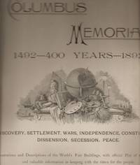
COLUMBUS MEMORIAL PROGRESS ACHIEVEMENT 1492-1892-DISCOVERY, SETTLEMENT,WARS,INDEPENDENCE,CONSTITUTION,DISSENSION,SECESSION,PEACE Illustrations and Descriptions of the World's Fair Buildings, with Official Plat of the Grounds and Valuable Information in Keeping with the Times for the People
by Iliff, John W. (Copyrighted by)
- Used
- Paperback
Monarch Book Company. VG. 1892. no edition/printing given. Softcover. Very good condition with light usage showing. Photo shows title page which is actually much lighter than shown. Covers are tan/dark blue lettering. Front cover and a few pages have a matching 1 1/2 inch tear at lower outer edge. Covers have some other minor edge tears. Covers also have some natural darkening with more around edges. Large handwritten compliments of Mrs. Cecli Abbot on opening front endpaper. Frontispiece is b/w illustration with Columbus in center surrounded by incidents in his llife such as Columbus in Ghana, on the road to Vallodolid, etc. All pages are quite clean and still stapled tight. Quite a few maps showing different discoveries of the Western Hemisphere, settlements and wars of North America, American Independence, etc. Also lots of b/w illustrations of the World's Fair buildings and their description such as the Horicultural and agricultural buildings, the women's buildings, the mines and mining building, etc. In giftable condition. Free gift wrapping, card and drop shipping. Let us know the occasion and message. ; 111/2x143/4; Unpaginated pages .
-
Bookseller
Seneca Valley Used Books & Paper Collectibles
 (US)
(US)
- Format/Binding Softcover
- Book Condition Used - VG
- Edition no edition/printing given
- Binding Paperback
- Publisher Monarch Book Company
- Date Published 1892
- Keywords American History Non-fiction, World's Fair American Columbus

Iliff's Select Readings For Public and Private Entertainment
by Iliff, John W
- Used
- poor
- Hardcover
- Condition
- Used - Poor
- Jacket Condition
- No Jacket
- Binding
- Hardcover
- Quantity Available
- 1
- Seller
-
Tolar, Texas, United States
- Item Price
-
NZ$8.51
Show Details
Item Price
NZ$8.51
Jack Ryan 3 Pack (The Hunt for Red October / Patriot Games / Clear and Present Danger)
by Donald Stewart [Writer]; John Milius [Writer]; Larry Ferguson [Writer]; Steven Zaillian [Writer]; Tom Clancy [Writer]; W. Peter Iliff [Writer];
- Used
- very good
- Condition
- Used - Very Good
- Quantity Available
- 1
- Seller
-
Ormond Beach, Florida, United States
- Item Price
-
NZ$11.52
Show Details
Description:
Paramount, 2007-01-01. DVD. Very Good. SHIPS FAST WITH TRACKING
Item Price
NZ$11.52
Iliffi's Imperial Atlas of the World: Title Page
by John W. Iliff & Co
- Used
- very good
- Condition
- Used - Very Good
- Quantity Available
- 1
- Seller
-
Boonsboro, Maryland, United States
- Item Price
-
NZ$25.02
Show Details
Description:
John W. Iliff & Company, 1893. Loose Leaf. Very Good. 14 x 10 3/4 inches. Title page only, extracted from Iliff's Imperial Atlas of the World. Vintage atlas title page. Title page text with steel plate decorative engraving. Verso has copyright information. Page in very good, near fine condition.
Item Price
NZ$25.02
Iliff's Imperial Atlas of the World Map of South Africa with Incomplete Chart of South Africa
by John W. Iliff and Co
- Used
- very good
- Condition
- Used - Very Good
- Quantity Available
- 1
- Seller
-
Boonsboro, Maryland, United States
- Item Price
-
NZ$50.04
Show Details
Description:
J.A. Stewart and Company, 1893. Map. Very Good. 11-1/4 x 14-1/2 inches. Full color, photo-printed map extracted from Iliffs renowned Imperial Atlas of 1893. Detailed and descriptive map of South Africa, separating by political borders and listing in lower left a reference guide to Fiscal Districts not shown on map. Map on reverse is a more detailed, yet incomplete map. Minimal discoloration to borders. Colors are bright and vivid. Crisp, clean lines. Text is easily legible, and impeccably detailed. A superior map in very good condition.
Item Price
NZ$50.04
Iliff's Imperial Atlas of the World Street Map of Cleveland, OH
by John W. Iliff and Co
- Used
- very good
- Condition
- Used - Very Good
- Quantity Available
- 1
- Seller
-
Boonsboro, Maryland, United States
- Item Price
-
NZ$50.04
Show Details
Description:
J.A. Stewart and Company, 1893. Map. Very Good. 11 x 14-1/2 inches. Full color steel plate engraved street map of Cleveland, OH, extracted from Iliffs Imperial Atlas of the World. Partial map of Pittsburgh and Allegheny City on opposite page. Includes an explanation key detailing roads and railroads. Slight tear to upper margin from extraction. Minor discoloration to borders. Lines remain crisp and clean. A superior map in very good condition.
Item Price
NZ$50.04
Arms of Various Nations (Extracted From Iliff's Imperial Atlas of the World)
by John W. Iliff and Co
- Used
- very good
- Condition
- Used - Very Good
- Quantity Available
- 1
- Seller
-
Boonsboro, Maryland, United States
- Item Price
-
NZ$50.04
Show Details
Description:
J.A. Stewart and Company, 1893. Map. Very Good. 11-1/4 x 14-1/2 inches. Full color steel plate illustration depicting coats of arms from various nations around the world, including the United States, Great Britain, Germany, France and many others. Extracted from John W. Iliff's Imperial Atlas of the World. Reverse page includes two charts: One detailing the level of debt on a yearly basis accrued by various nations, and the second detailing Americas debt between 1880 and 1890. Slight chipping to page edge from extraction. Mild discoloration to bottom of page. Bright and vivid colors. Sharp, clean lines and text. A superior print in very good condition.
Item Price
NZ$50.04
Iliff's Imperial Atlas of the World Map Showing the Territorial Growth of the United States
by John W. Iliff and Co
- Used
- very good
- Condition
- Used - Very Good
- Quantity Available
- 1
- Seller
-
Boonsboro, Maryland, United States
- Item Price
-
NZ$50.04
Show Details
Description:
J.A. Stewart and Company, 1893. Map. Very Good. 11 x 15 inches. Full color steel plate engraved map of The United States, depicting territorial growth from East to West, extracted from Ilifs Imperial Atlas of the World. Reverse side contains a chart depicting comparative lengths of principle world river, and comparative heights of principle mountains. Slight discoloration to borders. Bright, vivid colors. Lines are crisp and clean. Text is neat and legible. A superior map in very good condition.
Item Price
NZ$50.04
Iliff's Imperial Atlas Map of New Zealand with Half-page of North Africa
by John W. Iliff and Co
- Used
- very good
- Condition
- Used - Very Good
- Quantity Available
- 1
- Seller
-
Boonsboro, Maryland, United States
- Item Price
-
NZ$50.04
Show Details
Description:
J.A. Stewart and Company, 1893. Map. Very Good. 11-1/4 x 14-1/2 inches. Full color, photo-printed map extracted from Iliffs renowned Imperial Atlas of 1893. New Zealand map contains reference guide to counties, and an embedded chart of Tasmania and the Bass Straight. Reverse side contains half of a map of North Africa and the Mediterranean Sea. Minimal discoloration to borders. Colors are bright and vivid. Crisp, clean lines. Text is easily legible, and impeccably detailed. A superior map in very good condition.
Item Price
NZ$50.04
Iliff's Imperial Atlas of the World Map of British Columbia
by John W. Iliff and Co
- Used
- very good
- Condition
- Used - Very Good
- Quantity Available
- 1
- Seller
-
Boonsboro, Maryland, United States
- Item Price
-
NZ$58.39
Show Details
Description:
J.A. Stewart and Company, 1893. Map. Very Good. 11 x 15 inches. Full color steel plate engraved map of British Columbia, extracted from Iliffs Imperial Atlas of the World. Reverse side contains a partial chart. Slight discoloration to borders. Bright, vivid colors. Lines are crisp and clean. Text is neat and legible. A superior map in very good condition.
Item Price
NZ$58.39
Iliff's Imperial Atlas of the World Maps of England and Wales, and Scotland
by John W. Iliff and Co
- Used
- very good
- Condition
- Used - Very Good
- Quantity Available
- 1
- Seller
-
Boonsboro, Maryland, United States
- Item Price
-
NZ$58.39
Show Details
Description:
J.A. Stewart and Company, 1893. Map. Very Good. 11-1/2 x 15 inches. Full color double sided steel plated engraved map, extracted from John W. Iliffs renowned Imperial Atlas of the World. Maps are color coded according to regions, and both include title plates and scales. Slight chipping to left border of England and Wales chart. Small pinholes as well. Minimal discoloration to borders. Lines are crisp and clear. Text is easily legible. A superior map in very good condition.
Item Price
NZ$58.39