Click for full-size.

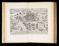
Description des Indes Occidentales, qu'on appelle aujourdhuy le Nouveau Monde: The first town plan of anywhere in the present-day United States" Par Antoine de Herrera, avec la Navigation du Vaillant Capitaine de Mer Jacques le Maire, & de plusieurs autres...
by HERRERA [Y TORDESILLAS], A de, [JACOB Le Maire, Willem CORNELIS SCHOUTEN, Giovanni Battista BOAZIO], et al
- Used
- Hardcover
- first
- Condition
- See description
- Seller
-
London, United Kingdom
Payment Methods Accepted
About This Item
Amsterdam,: Chez Emanuel Colin de Thovoyon,, 1622.. Folio (310 by 200mm), first French edition second issue (title page canncelled, with Paris imprint added to that of Amsterdam) engraved title with vignettes and map, [8], 103, [1, blank], [6], 107-254 pp., head- and tail-pieces, with decorated initials; 27 engraved plates, pictorial title page, 17 maps and charts (16 double-page, 1 folded), 4 city views, 5 text engravings (scenes from Le Maire voyage), portrait of Le Maire not present as usual for the French edition, seventeenth century vellum. The first French edition of Herrera'a rare work here extra-illustrated with Boazio's exceedingly rare views of Santo Domingo (Dominican Republic); Santiago (Cape Verde Islands); Cartagena (Columbia); and San Augustine (Florida) - first known engraving of any locality in the present-day United States. The importance of this French edition of Herrera's 'Description des Indes Occidentales', and the other 1622 editions in Latin and Dutch, lies in its engraved pictorial title page with the first map to delineate California as an Island and in the inclusion of the first comprehensive account of Jacob Le Maire's voyage. The 14 maps in the Herrera's section are almost identical to those in the original 1601 'Descripcion', save for some resizing and changes in a few details. The most interesting are probably the 'Description de las Yndias Occidentalis', which depicts the Papal line of demarcation dividing the world between Spain and Portugal, and the 'Description de las Indias del Poniente', which depicts a large part of the Pacific with the Moluccas, the Philippines and the Ladrones accurately positioned. Le Maire and Cornelis Schouten, his second in command, left Texel in June 1615 on a mission to find a new route to reach the Spices Islands which would break the trade monopoly of the Dutch East India Company (which had been grant a monopoly trade through the Strait of Magellan). The pair succeeded to break the monopoly by rounding south America south of the Straits of Magellan. The new cape was name Horn (or Hoorn) after Shouten's ship which had been lost due to fire at the Patagonian port Desire. In doing so they also dispelled the myth of a great southern continent joined to South America. They would continue to sail across the Pacific, discovering numerous islands along the way, and sailing up the northern coast of New Guinea. By September 1616 Le Maire reached Ternate in the Moluccas, the headquarters of the Dutch East India Company. Initially well received, they were soon accused of having encroached on the rights of the Company and were tried, found guilty and shipped home on Spilbergen's ship which was completing its own trip around the world. Le Maire died on the return voyage and his journals were taken by the Company. Schouten and Spibergen published an abreviated version of these journal; and it was not until 1622, after a long trial, that Isaac Le Maire was able to regain custody of his son's journals and to publish them in full. The four additional city views (Santo Domingo in the Dominican Republic; Santiago in the Cape Verde Islands; Cartagena in Columbia; and San Augustine, Florida) were drawn, and possibly engraved, by the Italian artist Baptista Boazio. The Boazio views are "probably the most interesting and important published graphic work pertaining to Drake and his career" Kraus. They are also the first representations of those four cities. Indeed, the view of St Augustine is the first known engraving of any locality in the present-day United States. Their history is uncertain. There is no indication that Boazio participated to the voyage but he must have obtained a version of these views from someone who did: "It was undoubtedly in the course of the return voyage that the author of this view-plan [of St. Augustine] was able to copy the figure of the Dorado fish [and of the other creatures decorating the plans] from John White's original drawings" Kraus. John White was the Governor of the first English settlement in America, who along with the other surviving settlers returned to England from Roanoke Island with Drake's expedition. Two issues of these views were printed in Leiden in 1588, both extremely rare: a large paper issue (16.5 by 22 inches) was printed to illustrate Walter Bigges and Master Croftes, 'A Summarie and true discourse of Sir Francis Drake's West Indian Voyage' published in London in 1589; the present smaller size (7.5 by 11.25 inches) has captions in Latin and French and a numerical instead of alphabetical key, and was probably printed to illustrate the Latin and French translations of 'A Summarie and true discourse', published in Leiden in 1588. While the pictures are broadly similar, the present examples show greater detail, whilst the larger ones include more sea monsters and other embellishments. Priority regarding date of publication between those two issues has not been established with certainty but there are indications that the smaller issue came first:
"A close comparison of details, however, suggests that the smaller engravings come from an earlier set of drawings and that the larger maps represent revisions as well as embellishments, probably done by the same artist" (Mary Frear Keeler).
There were two subsequent issues of the smaller Boazio plates: the first in 1589, published in Cologne, used the same plates but with only the Latin text below; the plates themselves are set within the text, with printed text to the verso; the second, 1590, Nuremberg printing was neither printed from new plates or the plates have been heavily revised. Only two complete sets of the four large views have appeared at auction in the last fifty years, each accompanied by an example of a map of Drake's Atlantic voyage: the DuPont sale at Christie s in 1991 for $231,000; and bound into the Macclesfield example of Saxton's atlas, Sotheby's, 2007, for £669,600. A large coloured view of Cartagena was sold at Christies in 1996 for $16,100.
There is no record of any copy of the 1588 smaller size issue having gone through auction. In 1970, Kraus, p.156, estimated that they were eight recorded complete sets of the large Boazio plates and seven complete sets of the smaller plates (1588 and 1589).
OCLC records eight complete sets of the large plates, but only two complete sets of the small 1588 plates: New York Public Library, and the Huntington Library. There is an incomplete set (lacking San Augustine) of the smaller 1588 plates in the Kraus' Sir Francis Drake Collection housed in the Library of Congress. Of the 1589 small plates we were able to trace nine complete examples.
A comparison of the Boazio maps in the present book with the plates in the Huntington Library, New York Public Library, and the Library of Congress confirm that the 4 sets are identical. For the 'Description des Indes Occidentales': Brunet III, cols 132-133; Burden 195-198; Cox I: 41n. 'European Americana' 1622/68; Medina, 'Biblioteca Hispano-Americana' 455n.; Tooley, 'California as an Island' 107; Wagner, 'Cartography of the Northwest Coast', pp. 145-146 & No. 291. For the Boazio plates: Burden 65 & 70; in the February 2016 'Addenda for The Mapping of North America', note 71, Burdern refers to this set and the number of known copies; Church 134A, 136, 138; H.P. Kraus, 'Sir Francis Drake, A Pictorial Biography', Amsterdam 1970, pp. 121-127 and nos. 20 & 49a; Mary Frear Keeler, 'Sir Francis Drake's West Indian Voyage' 1585 86. Hakluyt Society, London, 1981.
Reviews
(Log in or Create an Account first!)
Details
- Bookseller
- Daniel Crouch Rare Books Ltd
 (GB)
(GB)
- Bookseller's Inventory #
- 15084
- Title
- Description des Indes Occidentales, qu'on appelle aujourdhuy le Nouveau Monde:
- Author
- HERRERA [Y TORDESILLAS], A de, [JACOB Le Maire, Willem CORNELIS SCHOUTEN, Giovanni Battista BOAZIO], et al
- Book Condition
- Used
- Quantity Available
- 1
- Binding
- Hardcover
- Publisher
- Chez Emanuel Colin de Thovoyon,
- Place of Publication
- Amsterdam,
- Date Published
- 1622.
- Weight
- 0.00 lbs
- Product_type
- Books
Terms of Sale
Daniel Crouch Rare Books Ltd
Any item may be returned if you are not happy with it providing we are notified within 7 days of your receiving it. This does not affect any statutory rights you may have under UK or EU law for returning the item outside this period. All we ask is that you return the item(s) by the same or similar method to that in which they were sent to you. Your postage costs and any payment already received will be refunded immediately on our receipt of the items in the same condition as you received them.
About the Seller
Daniel Crouch Rare Books Ltd
Biblio member since 2018
London
About Daniel Crouch Rare Books Ltd
Daniel Crouch Rare Books is specialist dealer in antique atlases, maps, plans, sea charts and voyages dating from the fifteenth to the nineteenth centuries. Our carefully selected stock also includes a number of fine prints and globes, and a selection of cartographic reference books.Our particular passions include rare atlases, wall maps, and separately published maps and charts. We strive to acquire unusual and quirky maps that are in fine condition. We are members of the following trade associations: The Antiquarian Bookseller's Association (ABA); The British Antique Dealers' Association (BADA); Confédération Internationale des Négociantes en Oeuvres d'Art (CINOA); The International League of Antiquarian Booksellers (ILAB); The Society of London Art Dealers (SLAD); and The European Fine Art Foundation (TEFAF). Daniel and Nick are also both members of The Company of Art Scholars, Dealers, and Collectors.
Glossary
Some terminology that may be used in this description includes:
- Title Page
- A page at the front of a book which may contain the title of the book, any subtitles, the authors, contributors, editors, the...
- Vellum
- Vellum is a sheet of specialty prepared skin of lamb, calf, or goat kid used for binding a book or for printing and writing. ...
- New
- A new book is a book previously not circulated to a buyer. Although a new book is typically free of any faults or defects, "new"...
- Folio
- A folio usually indicates a large book size of 15" in height or larger when used in the context of a book description. Further,...
Frequently asked questions

The Importance of Dust Jackets
Is the dust jacket of a book worth holding on to? Consider its form, its function, and its beauty. Learn more about dust jackets and their importance to your collection.

Is your family bible valuable?
While they may have sentimental value, bibles passed down through the family are not often worth a lot of money. Learn more...
