Description:
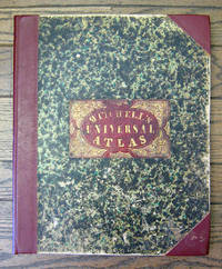
Philadelphia: S. Augustus Mitchell, 1849 Folio. (17 3/8 x 14 inches). Lithographed title with large vignette, letterpress "Table of Contents," and 73 hand-colored lithographed maps, charts and city plans. Three-quarter red morocco over marbled boards, large red morocco title label on front cover, elaborately tooled and lettered in gilt. Spine and corners renewed in red leather. Boards rubbed and scuffed at edges. Maps in fine condition. Overall, a fine copy. A very nice copy of this very scarce atlas, with hand-colored maps of all the individual States and Territories, and including the rare and famous map of "Oregon, Upper California & New Mexico" showing the large yellow-colored area in California labeled "Gold Region." The Atlas concentrates on the American continent with 43 maps of the area, including a fine double-page coast-to-coast map of the United States. Samuel Augustus Mitchell and his sons were the leading publishers of maps in the United States during…
Read More GEOLOGICAL MAP OF GLOUCESTERSHIRE, divided into hundreds, exhibiting its roads, rivers, parks, etc by John Cary Engraver Sept 1st 1819. by SMITH, William. MINERAL SURVEYOR.:
by SMITH, William. MINERAL SURVEYOR.:

GEOLOGICAL MAP OF GLOUCESTERSHIRE, divided into hundreds, exhibiting its roads, rivers, parks, etc by John Cary Engraver Sept 1st 1819.
by SMITH, William. MINERAL SURVEYOR.:
- Used
- first
London, J. Cary, 1819.. FIRST EDITION 1819. Handcoloured folding engraved map, dissected and laid on linen,15 sections, approximately 590 x 515 mm, 23¼ x 20¼ inches, housed in a plain marbled paper covered slipcase with printed paper title to spine. Map in very good condition, slipcase slightly rubbed. See: Memoirs of William Smith by John Phillips, Cambridge University Press, 2011, page 149; Dictionary of Scientific Biography, pages 486-492, the last sentence states "Certainly no one could deny Smith's right to the title Founder of Stratigraphical Geology"; John Challinor, The History of British Geology, page 97. MORE IMAGES ATTACHED TO THIS LISTING, ALL ZOOMABLE, FURTHER IMAGES ON REQUEST. POSTAGE AT COST.
-
Bookseller
Roger Middleton
 (GB)
(GB)
- Book Condition Used
- Place of Publication London, J. Cary, 1819.
- Keywords GEOLOGICAL MAP GLOUCESTERSHIRE cartography geology minerals geological strata paleography mining folding maps
More Photos
A New Universal Atlas Containing Maps of the various Empires, Kingdoms, State and Republics of the World. With a Special Map of each of the United States, Plans of Cities, &c.
by Mitchell, Samuel Augustus
- Used
- Hardcover
- first
- Condition
- Used
- Binding
- Hardcover
- Quantity Available
- 1
- Seller
-
San Francisco, California, United States
- Item Price
-
NZ$12,766.50
Show Details
Item Price
NZ$12,766.50

More Photos
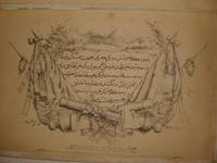
Avrupa-i Osmani Haritasi (Wall map of the Ottoman Europe), extra ordinary copy of an Ottoman lieutenant
- Used
- very good
- Condition
- Used - Very Good
- Quantity Available
- 1
- Seller
-
Riyadh, Saudi Arabia
- Item Price
-
NZ$11,915.40
Show Details
Description:
205 x 137 cm. extra ordinary Ottoman wall map of the Ottoman Europe prınted ın colors, folding paper on cloth. Signatures by the first lieutenant M. İhsan.
Item Price
NZ$11,915.40

More Photos
The Edinburgh Geographical and Historical Atlas
by John Hamilton
- Used
- Hardcover
- Condition
- Used - Very good +
- Binding
- Hardcover
- Quantity Available
- 1
- Seller
-
London, Ontario, Canada
- Item Price
-
NZ$12,766.50
Show Details
Description:
Edinburgh: John Hamilton, ca. 1831. Leatherbound. Very good +. 16, 288, 4 p. 49 cm. 68 hand-coloured maps, many fold-out, and one fold-out of Mountain Chains with b&w engraving. Plate 32 missing as stipulated in Contents. Scales differ. Rebound in half leather by Keith Felton. Gilt trim. Original boards. Occasional dampstains and thumbing. Tear in fold of plate 61. Repairs to edges and corners of Contents page. Earlier repairs to edges of Table of Mountain Chains, Chart of the World, fold-out map of the Russian Empire. Title continues: "Comprehending A Sketch of the History of Geography; A View of the Principles of Mathematical, Physical, Civil, and Political Geography; An Account of the Geography, Statistics, and History of Each Continent, State, and Kingdom, Delineated. And a Tabular View of the Principal Mountain Chains in the World. Engraved on Sixty-nine Copperplates, and Compiled from Materials Drawn from the Newest and most Authentic Sources." This magnificent atlas was published about 1831…
Read More Item Price
NZ$12,766.50

More Photos
抗美援朝時事學習地圖. [Kang Mei yuan Chao shi shi xue xi di tu]. [Current Affairs Study Map - Resisting US Aggression and Aiding Korea].
by [YA XIN CARTOGRAPHIC STUDY SOCIETY].[亞新地學社].
- Used
- first
- Condition
- Used
- Edition
- 1st Edition.
- Binding
- Unknown
- Quantity Available
- 1
- Seller
-
Canberra, Australian Capital Territory, Australia
- Item Price
-
NZ$3,059.65
Show Details
Description:
武昌.[Wuchang].: 亞新地學社.[Ya xin di xue she].. 1st Edition.. August1951.. Large detailed colour Chinese map of Korean War, folded, scale 1:15,000,000, three inset maps on corners, illustrated legend showing agricultural and mining resources lower margin, in original envelope. Some light wear along edges, small holes and wear at folds mended with archival tape, envelope torn with loss mended with archival tape. Inset map 兩個陣營力量對比 "Strength Comparison Between The Two Camps" upper left corner, scale 1: 170,000,000. The Peaceful Camp in red covering the majority of Asia and Europe, a list of 6 countries (Germany, Czech, Hungary, Romania, Bulgaria, Albania) are numbered and are also part of the Peaceful Camp. The Invader Camp in grey covering North America and small parts of Europe, a list of 3 nations (Netherlands, Belgium, Luxembourg) are numbered and are also part of the Invader Camp. Block of text in…
Read More Item Price
NZ$3,059.65
More Photos
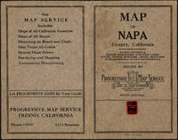
Napa County California. 1914
by Copyright 1914 by Punnett Brothers
- Used
- Condition
- Used
- Quantity Available
- 1
- Seller
-
FRAMINGHAM, Massachusetts, United States
- Item Price
-
NZ$1,617.09
Show Details
Description:
Map Details and Condition:color lithograph
dimensions: 26 3/4" x 19"
Brown Paper pocket covers with red bookstore label of Neal Stratford & Kerr, San Francisco
condition: professionally flattened and otherwise in as found, very good conditionDescription:
This 1914 map of now popular wine country Napa County, California shows the county in 1914, with early roads, largely undeveloped, vast open land areas, and natural features. The numbered grid system on this map reflects the Public Land Survey System. Large open tracts of land are identified as ranches, such as Rancho Catacoula, or Rancho Las Putas, Rancho LaJota all of which are large swaths of undivided land. Urban grids are shown in the southernmost part of Napa County, and sections of the southernmost sections of Sonoma County and Solano County. The cities of Petaluma, Sonoma, Vallejo and Napa and Benicia show populated urban areas. A corner of Marin County is shown.
C.F. Weber & Co. and the Punnett Brothers published… Read More
Item Price
NZ$1,617.09
More Photos
A New Universal Atlas Containing Maps of the various Empires, Kingdoms, State and Republics of the World. With a Special Map of each of the United States, Plans of Cities, &c.
by Mitchell, Samuel Augustus
- Used
- Hardcover
- first
- Condition
- Used
- Binding
- Hardcover
- Quantity Available
- 1
- Seller
-
San Francisco, California, United States
- Item Price
-
NZ$12,766.50
Show Details
Description:
Philadelphia: S. Augustus Mitchell, 1849 Folio. (17 3/8 x 14 inches). Lithographed title with large vignette, letterpress "Table of Contents," and 73 hand-colored lithographed maps, charts and city plans. Three-quarter red morocco over marbled boards, large red morocco title label on front cover, elaborately tooled and lettered in gilt. Spine and corners renewed in red leather. Boards rubbed and scuffed at edges. Maps in fine condition. Overall, a fine copy. A very nice copy of this very scarce atlas, with hand-colored maps of all the individual States and Territories, and including the rare and famous map of "Oregon, Upper California & New Mexico" showing the large yellow-colored area in California labeled "Gold Region." The Atlas concentrates on the American continent with 43 maps of the area, including a fine double-page coast-to-coast map of the United States. Samuel Augustus Mitchell and his sons were the leading publishers of maps in the United States during…
Read More Item Price
NZ$12,766.50
More Photos
RARE OTTOMAN MILITARY MAP OF KARA DAG (MONT NEGRO)
by Ottoman General Staff Section
- Used
- very good
- Condition
- Used - Very Good
- Quantity Available
- 1
- Seller
-
Riyadh, Saudi Arabia
- Item Price
-
NZ$8,511.00
Show Details
Description:
Istanbul: The general staff section, 1875 Map. Very Good. No Binding. Military map of Kara Dag (Mont Negro), Ottoman General staff section in 1291 (1875) after the map which made by the Austrian military geographical section in 1869 about Kara Dag and environs after the war and military movements of 1861-1862. Officially linen in colors by contemporary hands, 105 x 105 cm. Very rare..
Item Price
NZ$8,511.00
More Photos
Avrupa-i Osmani Haritasi (Wall map of the Ottoman Europe), extra ordinary copy of an Ottoman lieutenant
- Used
- very good
- Condition
- Used - Very Good
- Quantity Available
- 1
- Seller
-
Riyadh, Saudi Arabia
- Item Price
-
NZ$11,915.40
Show Details
Description:
205 x 137 cm. extra ordinary Ottoman wall map of the Ottoman Europe prınted ın colors, folding paper on cloth. Signatures by the first lieutenant M. İhsan.
Item Price
NZ$11,915.40
More Photos
The Edinburgh Geographical and Historical Atlas
by John Hamilton
- Used
- Hardcover
- Condition
- Used - Very good +
- Binding
- Hardcover
- Quantity Available
- 1
- Seller
-
London, Ontario, Canada
- Item Price
-
NZ$12,766.50
Show Details
Description:
Edinburgh: John Hamilton, ca. 1831. Leatherbound. Very good +. 16, 288, 4 p. 49 cm. 68 hand-coloured maps, many fold-out, and one fold-out of Mountain Chains with b&w engraving. Plate 32 missing as stipulated in Contents. Scales differ. Rebound in half leather by Keith Felton. Gilt trim. Original boards. Occasional dampstains and thumbing. Tear in fold of plate 61. Repairs to edges and corners of Contents page. Earlier repairs to edges of Table of Mountain Chains, Chart of the World, fold-out map of the Russian Empire. Title continues: "Comprehending A Sketch of the History of Geography; A View of the Principles of Mathematical, Physical, Civil, and Political Geography; An Account of the Geography, Statistics, and History of Each Continent, State, and Kingdom, Delineated. And a Tabular View of the Principal Mountain Chains in the World. Engraved on Sixty-nine Copperplates, and Compiled from Materials Drawn from the Newest and most Authentic Sources." This magnificent atlas was published about 1831…
Read More Item Price
NZ$12,766.50
![Map of Peking. 京城內外全圖 .[Jing cheng nei wai quan tu].](https://d3525k1ryd2155.cloudfront.net/h/215/732/1340732215.0.m.jpg)
Map of Peking. 京城內外全圖 .[Jing cheng nei wai quan tu].
by [BOXER REBELLION MAP OF BEIJING].
- Used
- Condition
- Used
- Binding
- Unknown
- Quantity Available
- 1
- Seller
-
Canberra, Australian Capital Territory, Australia
- Item Price
-
NZ$8,622.65
Show Details
Description:
(Circa1900).. Large illustrated map of Beijing showing the city in the period following the invasion of the military forces of the Eight National Alliance, old folds, scale not given. Some scattered light foxing particularly at edges, short closed tear at fold lower edge, neat non acidic tape repair short section upper edge wear along folds, and a couple of small, unobtrusive holes with minor image loss. Blocks of text in traditional Chinese right and left upper sections stating each nation's occupied zone, Japanese text title accompanies the English title along the upper section of the map. 63.7 x 56.9cm. Very good overall. A rare and significant large Japanese woodblock map of Peking (Beijing), issued just after the suppression of the Boxer Rebellion. Centred on the Forbidden City, the map depicts Peking following the multinational suppression of the Boxer Rebellion or Yihetuan Movement of 1900. The map was issued to illustrate the areas of occupation associated with each of the powers in the Eight…
Read More Item Price
NZ$8,622.65

More Photos
The Sky and the Forest
by Forester, C.S
- Used
- very good
- Hardcover
- first
- Condition
- Used - Very Good
- Jacket Condition
- Very Good
- Edition
- First Edition
- Binding
- Hardcover
- Quantity Available
- 1
- Seller
-
Salem, Oregon, United States
- Item Price
-
NZ$59.39NZ$35.63Save NZ$13.96!
Show Details
Description:
C.S. Forester: The Sky and the Forest. Little, Brown and Company, Boston. Stated First Edition First Printing Thus August, 1948. Cover price $2.75. Used. VG BOOK/VG UNCLIPPED DUST JACKET. A story of a central Africa. By C.S. Forester, author of the Admiral Hornblower series.
Item Price
NZ$59.39NZ$35.63
Save NZ$13.96
!
![Alaska and Klondike Region; [With inset of Klondike Region on the Upper Yukon detail] [From an...](https://d3525k1ryd2155.cloudfront.net/h/062/537/1339537062.0.m.jpg)
Alaska and Klondike Region; [With inset of Klondike Region on the Upper Yukon detail] [From an atlas, "Gazetteer of Alaska and Yukon Region " pp. 105 and 106]
by Miller, J. Martin
- Used
- very good
- Condition
- Used - Very Good
- Edition
- Unknown
- Quantity Available
- 1
- Seller
-
Sebastopol, California, United States
- Item Price
-
NZ$66.39
Show Details
Description:
Chicago: J. Martin Miller, 1899. Unknown. Map. Very Good. [Map copyright 1899, printing date of Atlas later] [19.875x15.125in]; Colored map of Alaska with steamer routes from Portland and Seattle, insets of the Klondike Region on the Upper Yukon and Western portion of Aleutian Islands; On verso index of places and names with two large black and white images; Age toning to all edges, water stain marks on bottom, slight printing offset of colors, small chips and closed tears to lower edge;.
Item Price
NZ$66.39

Zemepis Sveta - Monsunova Asie
by De La Blache, P. Vidal; Gallois, L
- Used
- Hardcover
- Condition
- Used - Very Good Condition
- Jacket Condition
- No Dust Jacket
- Binding
- Hardcover
- Quantity Available
- 1
- Seller
-
Oak Point, Texas, United States
- Item Price
-
NZ$102.13
Show Details
Description:
Aventinum, Prague, Czechoslovakia, 1931. Hardcover. Very Good Condition/No Dust Jacket. Text entirely in Czech. Geography book on Asia with numerous photographs and maps. 1930 edition also available. Size: 4mo - over 9 3/4" - 12" tall. 400 pp. Pages are yellowed, but are tight and clean. Moderate shelfwear along the spine. Corners are lightly bumped. Quantity Available: 1. Shipped Weight: 3-5 pounds. Category: Travel & Places; Non-English Language::Czech; Pictures of this item not already displayed here available upon request. Inventory No: 001228. . Additional shipping charges may apply.
Item Price
NZ$102.13

Zemepis Sveta - Monsunova Asie
by De La Blache, P. Vidal; Gallois, L
- Used
- Hardcover
- Condition
- Used - Very Good Condition
- Jacket Condition
- No Dust Jacket
- Binding
- Hardcover
- Quantity Available
- 1
- Seller
-
Oak Point, Texas, United States
- Item Price
-
NZ$102.13
Show Details
Description:
Aventinum, Prague, Czechoslovakia, 1930. Hardcover. Very Good Condition/No Dust Jacket. Text entirely in Czech. Geography book on Asia with numerous photographs and maps. 1931 edition also available. Size: 4mo - over 9 3/4" - 12" tall. 400 pp. Pages are yellowed, but are tight and clean. Moderate shelfwear along the spine. Corners are lightly bumped. Quantity Available: 1. Shipped Weight: 3-5 pounds. Category: Travel & Places; Non-English Language::Czech; Pictures of this item not already displayed here available upon request. Inventory No: 001227. . Additional shipping charges may apply.
Item Price
NZ$102.13

North America from the Best Authorities, Russell, ca.1800
by Russell
- Used
- Condition
- Used
- Quantity Available
- 1
- Seller
-
Plymouth, Devon, United Kingdom
- Item Price
-
NZ$42.59
Show Details
Description:
Russell, J. : A General Map of North America from the Best Authorities. Nd but ca.1800. From "A New Geographical, Historical and Commercial Grammar and Present State of Several Kingdoms of the World." Copper engraving. Size approx 200 x 230mm. Two neat folds. Some age colouring to edges, otherwise very clean and bright.
Item Price
NZ$42.59

Asia from the Best Authorities, Russell, ca.1800
by Russell
- Used
- Condition
- Used
- Quantity Available
- 1
- Seller
-
Plymouth, Devon, United Kingdom
- Item Price
-
NZ$42.59
Show Details
Description:
Russell, J. : Asia from the Best Authorities. Nd but ca.1800. From "A New Geographical, Historical and Commercial Grammar and Present State of Several Kingdoms of the World". Copper engraving. Size approx 200 x 230mm. Two neat folds. Some age colouring to edges, otherwise clean and bright. Includes Arabia, India, Borneo, Japan, China and eastern Russia.
Item Price
NZ$42.59
![MAP OF UTAH [Territory]](https://d3525k1ryd2155.cloudfront.net/h/836/461/1485461836.0.m.jpg)
More Photos
MAP OF UTAH [Territory]
- Used
- Condition
- Used - Very Good-
- Edition
- Original
- Quantity Available
- 1
- Seller
-
Williamsburg, Virginia, United States
- Item Price
-
NZ$110.64
Show Details
Description:
New York, Richmond, Chicago, & Toledo: H. H. Hardesty, 1885. Original color lithographed map printed by Rand, McNally & Company, Engravers and published in HARDESTY'S HISTORICAL AND GEOGRAPHICAL ENCYCLOPEDIA: SPECIAL VIRGINIA EDITION. 19 3/8 inches by 13 1/4 inches on a 21" X 14 1/2" sheet. The map depicts the Territory of Utah in its final form--large areas had been removed and ceded to Nevada, Colorado, Wyoming, and Nebraska since Utah became a U. S. Territory in 1850. The issue of polygamy prevented statehood until it was finally granted in 1896. This map features railroads and topography and uses color to set off counties from each other. Unlike most atlas maps of the period, this map identifies most small towns. The map is guaranteed to be moe than 135 years old. The map is in about very good condition: generally clean and bright, with slight toning of paper and one faint water stain near the center-left edge of the map.. Original. Single Sheet. Very Good-. Elephant…
Read More Item Price
NZ$110.64

Philips Special Map of the Nile, The Advance on Khartum and the Environs of Omdurman. Cc1900
by George Philips and Son,
- Used
- Condition
- Used
- Quantity Available
- 1
- Seller
-
Plymouth, Devon, United Kingdom
- Item Price
-
NZ$55.37
Show Details
Description:
Philips Special map of the Nile illustrating the Advance on Khartum [Khartoum] with an enlargement of the environs of Omdurman [Omdur]. George Philips and Son, London and Liverpool Ca 1900. 580mm x 900mm folded map. Front title wrapper has come loose, not affecting map area. Three maps are displayed within the sheet. Map1. Map of the Nile Valley 520mm x 300mm showing the approaches of Khartum. Scale 1inch to 100 Geographical miles. Coloured indicating Possessions and Protectorates of European Powers. Map 2. Special map of the Nile from Dongola to Khartum. Scale 16 miles to the inch. Coloured. In set in this map is Map3. Environs of Omdurman, Scale 5 statute miles to the inch. Some small breaks at some folds, not affecting imagery or use of map. Title label is damaged, the map is clean and bright, probably unused. A very interesting record.
Item Price
NZ$55.37

Last Tales
by Dinesen, Isak
- Used
- very good
- Hardcover
- first
- Condition
- Used - Very Good
- Jacket Condition
- Good+
- Edition
- First Edition
- Binding
- Hardcover
- Quantity Available
- 1
- Seller
-
Salem, Oregon, United States
- Item Price
-
NZ$204.26NZ$122.56Save NZ$48.00!
Show Details
Description:
Dinesen, Isak: Last Tales, A Collection of Twelve New Tales of Compelling Beauty 1957, Random House. First Edition. Stated First Printing Thus. Used. Very Good/Good+ original red dust jacket, price-clipped. Jacket states 11/57 on front flap. 5 3/4 X
Item Price
NZ$204.26NZ$122.56
Save NZ$48.00
!

The Adventure of Wrangel Island
by Vilhjalmur Stefansson
- Used
- good
- Hardcover
- first
- Condition
- Used - Good
- Jacket Condition
- No DJ Included
- Edition
- First Edition
- Binding
- Hardcover
- Quantity Available
- 1
- Seller
-
Salem, Oregon, United States
- Item Price
-
NZ$212.59NZ$127.55Save NZ$49.96!
Show Details
Description:
The Adventure of Wrangel Island, Alaska (1925 Macmillan 1st Edition) HISTORY OF ALASKA. EXLIB. Good Condition/ No DJ included. Fold-out map affixed to binding at the back of the book has never been opened. The story of the (unsuccessful) attempted colonization of Wrangel Island Alaska. 413 pages plus appendix, Index. Titling is still bright. A clean, solid copy. Scarce.
Item Price
NZ$212.59NZ$127.55
Save NZ$49.96
!
