Description:
Paperback. Very Good.
Kingdom of the Netherlands, Including the Grand Duchy of Luxembourg, with the Post Roads and Stations, Likewise the Limits as Settled by the Treaty of Paris, Nov. 20th,1815 by William Faden - 1820
by William Faden
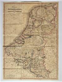
Kingdom of the Netherlands, Including the Grand Duchy of Luxembourg, with the Post Roads and Stations, Likewise the Limits as Settled by the Treaty of Paris, Nov. 20th,1815
by William Faden
- Used
Charing Cross, London: William Faden, Royal Geographer to King George III, 1820. Single Sheet / Folded Map. Vg. Single, linen backed, dissected colour map of the Netherlands - 32 x 22.5 inches folding into 21 panels. Engraved by Neele and Son and published by William Faden (1749-1836) English cartographer and publisher. Excellent overall with light age toning. No tears or holes along the edges or seams. No slipcase available. Inquiries welcome.
-
Seller
Independent bookstores
 (CA)
(CA)
- Format/Binding Single Sheet / Folded Map
- Book Condition Used - Vg
- Quantity Available 1
- Publisher William Faden, Royal Geographer to King George III
- Place of Publication Charing Cross, London
- Date Published 1820
- Keywords Cartography Maps Holland Netherlands Antique Maps Post Roads and Postal Stations William Faded Geography Map Making Engravers English Cartographer

Faden's Map of Norfolk
by Faden, William
- Used
- very good
- Paperback
- Condition
- Used - Very Good
- Binding
- Paperback
- ISBN 10 / ISBN 13
- 9780948400094 / 0948400099
- Quantity Available
- 3
- Seller
-
GORING BY SEA, West Sussex, United Kingdom
- Item Price
-
NZ$19.66
Show Details
Item Price
NZ$19.66

Stock Photo: Cover May Be Different
The Maritime Campaign Of 1778: A Collection Of All The Papers Relative To The Operations Of The English And French Fleets : To Which Are Added, ... The Ministry, Concerning The Engagement On..
by John Matthews (R.N.), William Faden
- Used
- good
- Paperback
- Condition
- Used - Good
- Binding
- Paperback
- ISBN 10 / ISBN 13
- 9781279844533 / 1279844531
- Quantity Available
- 1
- Seller
-
HOUSTON, Texas, United States
- Item Price
-
NZ$39.27
Show Details
Description:
Nabu Press, 2012-04-09. Paperback. Good.
Item Price
NZ$39.27

Faden's Map of Norfolk
by William Faden
- Used
- good
- Paperback
- Condition
- Used - Good
- Binding
- Paperback
- ISBN 10 / ISBN 13
- 9780948400094 / 0948400099
- Quantity Available
- 1
- Seller
-
Wellington, New Zealand
- Item Price
-
NZ$15.00
Show Details
Description:
UK: Lark's Press. Good. Paperback. 1989. 54 pages. .
Item Price
NZ$15.00

Stock Photo: Cover May Be Different
Atlas Minimus Universalis, or, A Geographical Abridgement Ancient and Modern of the Several Parts of the Earth: in Fifty-five Maps Composed Principally for the Use of Schools, &c
by William 1749-1836 Faden
- New
- Paperback
- Condition
- New
- Binding
- Paperback
- ISBN 10 / ISBN 13
- 9781014675781 / 1014675782
- Quantity Available
- 10
- Seller
-
Southport, Merseyside, United Kingdom
- Item Price
-
NZ$31.92
Show Details
Description:
Paperback / softback. New.
Item Price
NZ$31.92
Stock Photo: Cover May Be Different
Atlas Minimus Universalis, or, A Geographical Abridgement Ancient and Modern of the Several Parts of the Earth: in Fifty-five Maps Composed Principally for the Use of Schools, &c
by William 1749-1836 Faden
- New
- Paperback
- Condition
- New
- Binding
- Paperback
- ISBN 10 / ISBN 13
- 9781014675781 / 1014675782
- Quantity Available
- 10
- Seller
-
Southport, Merseyside, United Kingdom
- Item Price
-
NZ$39.46
Show Details
Description:
Paperback / softback. New.
Item Price
NZ$39.46

Pennsylvania Review: Spring 1967, Volume 1, No. 2
by (BAUM, Philip S., Charles Steiner, William Coleman, Barbara Faden, Charles Steiner, Oreste D'Arconte, Richard Cooper, Dr. Emily Wallace) MANGIONE, Jerre, faculty advisor
- Used
- very good
- Signed
- first
- Condition
- Used - Very Good
- Quantity Available
- 1
- Seller
-
Gloucester City, New Jersey, United States
- Item Price
-
NZ$127.66
Show Details
Description:
Philadelphia: Pennsylvania Review, University of Pennsylvania, 1967. Softcover. Very Good. First edition. Illustrated. Stapled wrappers. 53pp. Bottom corner creased and flared, spine tanned, very good. Inscribed by Jerre Mangione to poet Daniel Hoffman on the front wrapper. "A Conversation with William Styron." "Ezra Pound and William Carlos Williams at Penn" by Emily Wallace. Contributions by Philip S. Baum, Charles Steiner, William Coleman, Barbara Faden, Charles Steiner, Oreste D'Arconte, Richard Cooper, Dr. Emily Wallace.
Item Price
NZ$127.66

More Photos
A Map Of The Austrian Possessions In The Netherlands Or Low Countries With The Principalities Of Liege And Stavelo, &C. Reduced From The Trigonomic Survey Made By The Order Of H.R.H. The Prince Charles Of Lorraine
by Faden, William
- Used
- Condition
- Used
- Quantity Available
- 1
- Seller
-
Port Hope, Ontario, Canada
- Item Price
-
NZ$246.82
Show Details
Description:
Published in Faden's New General Atlas, 1811, 1794. 28" x 21"- 71.1 x 53.3 cm. Copper engraved map with old hand colouring. Offsetting to the North Sea, two short tears to right margin extending just past neatline, dampstain to lower margin, on the whole very good. A very detailed double page map showing the Netherlands, Flanders, parts of France, Luxembourg and Germany. Cf Phillips 6010, 6013, 6047.
William Faden was a prominent Scottish mapmaker (he dropped the "Mac" from his name when he moved to London), Royal Geographer to King George III and publisher during the late 19th and early 19th Centuries. He produced one of the finest set of maps during the American Revolution, as well as producing detailed charts from around the world.
Item Price
NZ$246.82

Chorographical Map of the Kingdom of Portugal Divided into it's Grand Provinces
by FADEN, William
- Used
- very good
- Condition
- Used - very good
- Quantity Available
- 1
- Seller
-
New York, New York, United States
- Item Price
-
NZ$340.44
Show Details
Description:
London: William Faden, 1797. unbound. very good. Map. Engraving with original hand coloring. Image measures 29" x 20".<br/><br/> Beautiful topographical details. Minor aging around edges.<br/><br/>
Item Price
NZ$340.44

The Roads of Great Britain
by Faden, William
- Used
- Condition
- Used - VG : in very good condition with rubbed slipcase. Light offsetting around folds
- Edition
- Third Edition
- Quantity Available
- 1
- Seller
-
Alnwick, Northumberland, United Kingdom
- Item Price
-
NZ$340.72
Show Details
Description:
London: Wm Faden, Geographer to the King. VG : in very good condition with rubbed slipcase. Light offsetting around folds. 1800. Third Edition. Dissected and mounted onto Linen. 750mm x 610mm (30" x 24"). 20 panels. Hand-coloured [not Scotland]. The text at the head of this map, incongruously for 1800, reads 'Itineraire de la Grande Bretagne'. .
Item Price
NZ$340.72

More Photos
A Map of the Roads of Great Britain Shewing the Distance Between Each Town and Also from London
by Faden William [ Publisher ]
- Used
- Condition
- Used - Near Very Good
- Quantity Available
- 1
- Seller
-
CHESHUNT, Hertfordshire, United Kingdom
- Item Price
-
NZ$372.66
Show Details
Description:
London: W. Faden , 1833. Large folding coloured linen backed map. Map measures 59x75.cm, in 24 sections, without slipcase. Map has some light wear, very minor holes on a few folds, minor dust marking. Generally a nice clean map.F . Near Very Good.
Item Price
NZ$372.66
