
Click for full-size.
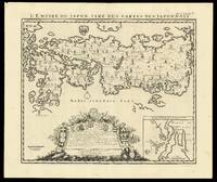
L'Empire du Japon Tiré des Cartes des Japponois: Henri Chatelain's edition of Adrien Reland's important map of Japan 1715
by CHÂTELAIN, Zacharie and CHÂTELAIN, Henri Abraham
- Used
- Condition
- See description
- Seller
-
London, United Kingdom
Payment Methods Accepted
About This Item
[Amsterdam,: François L'Honoré & Compagnie Libraries,, 1719].. 440 by 520mm. (17.25 by 20.5 inches).. Engraved map. Henri Chatelain's edition of Adrien Reland's important map of Japan 1715, including the place-names in phonetic Dutch. Reland's map of Japan represents a radical departure from prior European maps of Japan, and is the first map printed in Japan to use Sino-Japanese characters. Instead of using the existing European geographical sources of Japan, Reland utilized Japanese maps, most notably a map from the library of Benjamin Dutry (1668-1751), a former director of the Dutch VOC. This was a tremendous leap forward in the geographical depiction of Japan, such as in the treatment of Kyushu Island and in naming the 66 provinces. Large inset of the area around Nagasaki and an ornate dedication cartouche, with about twenty coats of arms. Published in the fifth volume of the Châtelain family's 'Atlas historique, ou Nouvelle introduction à l'Histoire, à la Chronologie & à la Géographie Ancienne et Moderne
', 1719, when eventually extended to 7 volumes. With an inset 'Vue de la Ville de Nangasacki & de l'ile'. Zacharie Châtelain (d. 1723) was the father of Henri Abraham (1684-1743) and Zacharie Junior (1690-1754). They worked as a partnership publishing the 'Atlas
' under several different Châtelain imprints, depending on the Châtelain family partnerships at the time of publication. The atlas was published in seven volumes between 1705 and 1720, with a second edition appearing in 1732. The maps were accompanied by information pertaining to cosmography, geography, history, chronology, genealogy, topography, heraldry, and costume of the world. The maps in the "Atlas Historique" were mainly based on those of the French cartographer, Guillaume De L'Isle, but were presented by the Châtelains in an encyclopaedia form. The accompanying text is in French and often is printed in two columns on the page with maps and other illustrations interspersed. Each map and table is numbered consecutively within its volume and all maps bear the privileges of the States of Holland and West-Friesland. Hubbard 73.
Reviews
(Log in or Create an Account first!)
Details
- Bookseller
- Daniel Crouch Rare Books Ltd
 (GB)
(GB)
- Bookseller's Inventory #
- 15847
- Title
- L'Empire du Japon Tiré des Cartes des Japponois
- Author
- CHÂTELAIN, Zacharie and CHÂTELAIN, Henri Abraham
- Book Condition
- Used
- Publisher
- François L'Honoré & Compagnie Libraries,
- Place of Publication
- [Amsterdam,
- Date Published
- 1719].
- Product_type
- Maps
- Size
- 440 by 520mm. (17.25 by 20.5 inches).
- Note
- May be a multi-volume set and require additional postage.
Terms of Sale
Daniel Crouch Rare Books Ltd
Any item may be returned if you are not happy with it providing we are notified within 7 days of your receiving it. This does not affect any statutory rights you may have under UK or EU law for returning the item outside this period. All we ask is that you return the item(s) by the same or similar method to that in which they were sent to you. Your postage costs and any payment already received will be refunded immediately on our receipt of the items in the same condition as you received them.
About the Seller
Daniel Crouch Rare Books Ltd
Biblio member since 2018
London
About Daniel Crouch Rare Books Ltd
Daniel Crouch Rare Books is specialist dealer in antique atlases, maps, plans, sea charts and voyages dating from the fifteenth to the nineteenth centuries. Our carefully selected stock also includes a number of fine prints and globes, and a selection of cartographic reference books.Our particular passions include rare atlases, wall maps, and separately published maps and charts. We strive to acquire unusual and quirky maps that are in fine condition. We are members of the following trade associations: The Antiquarian Bookseller's Association (ABA); The British Antique Dealers' Association (BADA); Confédération Internationale des Négociantes en Oeuvres d'Art (CINOA); The International League of Antiquarian Booksellers (ILAB); The Society of London Art Dealers (SLAD); and The European Fine Art Foundation (TEFAF). Daniel and Nick are also both members of The Company of Art Scholars, Dealers, and Collectors.
Glossary
Some terminology that may be used in this description includes:

Is your family bible valuable?
While they may have sentimental value, bibles passed down through the family are not often worth a lot of money. Learn more...

Using and Collecting Bookmarks
Bern Marcowitz warns against paperclips and other inappropriate page-savers, and offers a bit of advice on using and collecting bookmarks.
