Click for full-size.
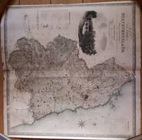
Map of the County of Northumberland from an actual survey made in the years 1827 & 1828
by Greenwood, C & I
- Used
- good
- Condition
- Good
- Seller
-
Hexham, Northumberland, United Kingdom
Payment Methods Accepted
About This Item
London: Greenwood, 1831. No Binding. Good. Flat, rolled; the map has been folded vertically in half at one point and has been reinforced at the fold. VERY RARE There will be a slight increase in postage required for this item.
Reviews
(Log in or Create an Account first!)
Details
- Seller
- Bennor Books
 (GB)
(GB)
- Seller's Inventory #
- 004094
- Title
- Map of the County of Northumberland from an actual survey made in the years 1827 & 1828
- Author
- Greenwood, C & I
- Format/Binding
- No Binding
- Book Condition
- Used - Good
- Quantity Available
- 1
- Publisher
- Greenwood
- Place of Publication
- London
- Date Published
- 1831
- Weight
- 0.00 lbs
- Keywords
- CARTOGRAPHY, MAPS
- Bookseller catalogs
- Northumberland & North East England;
- Product_type
- Map
Terms of Sale
Bennor Books
30 day return guarantee, with full refund including original shipping costs for up to 30 days after delivery if an item arrives misdescribed or damaged.
About the Seller
Bennor Books
Biblio member since 2016
Hexham, Northumberland
About Bennor Books
I specialise in used books covering all aspects of Northumberland, North East England and the Scottish Borders and the associated fields of railways and mining. I also hold books on prehistoric art and titles on field sports in the 19th and 20th centuries. As I sell on commission, I often have a wide range of uncommon titles on other subjects.
With regret, I can no longer accept orders from France or Germany.
With regret, I can no longer accept orders from France or Germany.

Collecting One Book
Instead of collecting by series, author, publisher...why not just one title? Learn more about collecting variations and editions of one book.

Collecting Vintage Valentine’s Day Cards
Exchanging Valentines can be an awkward process, especially when you consider “Vinegar Valentines” and other snarky sentiments - whatever your tastes, enjoy the sweet and sour cards alike in this gallery!
Also Recommended
-

-

-
-

-

Save 10% on every purchase!
Join the Bibliophiles’ Club and start saving 10% on every book.
$29.95 / Year
