
Click for full-size.
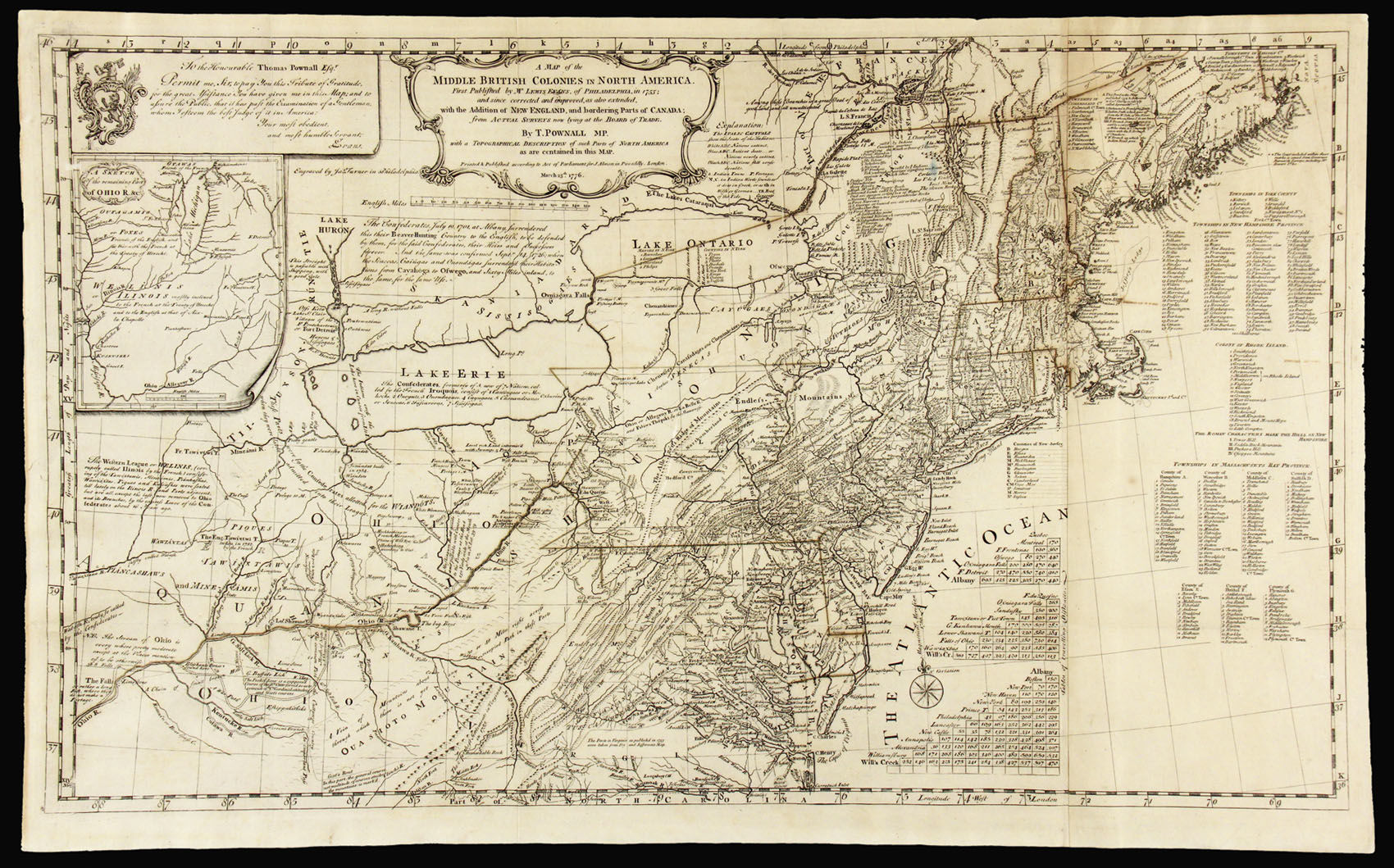
A Map of the Middle British Colonies in North America: British Colonies in America First Published by Mr. Lewis Evans, of and since corrected and improved, as also extended, with the addition of New England, and bordering parts of Canada; from actual surveys ... by T. Pownall ...March 25th, 1776
by POWNALL, Thomas & EVANS, Lewis
- Used
- Signed
- Condition
- See description
- Seller
-
London, United Kingdom
Payment Methods Accepted
About This Item
London,: J. Almon,, 1776.. 530 by 860mm. (20.75 by 33.75 inches).. Large engraved map, 2 sheets joined (490 by 840mm to the neatline, full margins showing the plate mark), (laid down on archival paper, old folds). A fine engraved and comprehensive map of the northeastern states of America from the borders with Nova Scotia and New France in the north to Chesapeake Bay in the south, west to Ohio and beyond, from Evans' original map, and extended to include the coastline by Pownall, with an inset of the "Remaining Part of the Ohio R. etc." Published in "A Topographical Description of Such Parts of North America as are Contained in the (Annexed) Map of the Middle British Colonies, &c in North America", 1776. This is by far the most important issue of Evans' map published after his original of 1755 which Schwartz calls "the most ambitious performance of its kind undertaken in America up to that time." Evans' was the first to map with general accuracy the trans-Appalachian region and parts of the midwest. Pownall's was the only subsequent issue of the Evans map to use the original plate. In an unusual piece of cartographic augmentation, Pownall produced a new plate of the northeast that was not on the original Evans plate and appended it. Pownall, who had been governor of Massachusetts, stated that the New England section of the map was based on new information, "later Draughts and Surveys deposited at the Board of Trade" (Pownall). As Stevens observed, Pownall also significantly updated the original plate: "the whole of the map east of the longitude of Philadelphia is greatly changed, and is filled in with new details". Unlike the pirated editions of the Evans map by Jefferys, Sayer, Kitchen and Bowles, Pownall's was authorized by Evans. In fact, a commendation of the map signed by Evans appears in the upper left-hand corner. Streeter, Lewis Evans His Map, pp.17-28; Schwartz/Ehrenberg, p.162, pl. 98.
Reviews
(Log in or Create an Account first!)
Details
- Seller
- Daniel Crouch Rare Books Ltd
 (GB)
(GB)
- Seller's Inventory #
- 12808
- Title
- A Map of the Middle British Colonies in North America
- Author
- POWNALL, Thomas & EVANS, Lewis
- Book Condition
- Used
- Publisher
- J. Almon,
- Place of Publication
- London,
- Date Published
- 1776.
- Keywords
- Pownall, Evans, North America, rare map, antique map
- Product_type
- Maps
- Size
- 530 by 860mm. (20.75 by 33.75 inches).
Terms of Sale
Daniel Crouch Rare Books Ltd
Any item may be returned if you are not happy with it providing we are notified within 7 days of your receiving it. This does not affect any statutory rights you may have under UK or EU law for returning the item outside this period. All we ask is that you return the item(s) by the same or similar method to that in which they were sent to you. Your postage costs and any payment already received will be refunded immediately on our receipt of the items in the same condition as you received them.
About the Seller
Daniel Crouch Rare Books Ltd
Biblio member since 2018
London
About Daniel Crouch Rare Books Ltd
Daniel Crouch Rare Books is specialist dealer in antique atlases, maps, plans, sea charts and voyages dating from the fifteenth to the nineteenth centuries. Our carefully selected stock also includes a number of fine prints and globes, and a selection of cartographic reference books.Our particular passions include rare atlases, wall maps, and separately published maps and charts. We strive to acquire unusual and quirky maps that are in fine condition. We are members of the following trade associations: The Antiquarian Bookseller's Association (ABA); The British Antique Dealers' Association (BADA); Confédération Internationale des Négociantes en Oeuvres d'Art (CINOA); The International League of Antiquarian Booksellers (ILAB); The Society of London Art Dealers (SLAD); and The European Fine Art Foundation (TEFAF). Daniel and Nick are also both members of The Company of Art Scholars, Dealers, and Collectors.
Glossary
Some terminology that may be used in this description includes:
- Plate
- Full page illustration or photograph. Plates are printed separately from the text of the book, and bound in at production. I.e.,...
- Fine
- A book in fine condition exhibits no flaws. A fine condition book closely approaches As New condition, but may lack the...
- New
- A new book is a book previously not circulated to a buyer. Although a new book is typically free of any faults or defects, "new"...
Frequently asked questions
This Book’s Categories

Is your family bible valuable?
While they may have sentimental value, bibles passed down through the family are not often worth a lot of money. Learn more...

Signed vs. Inscribed
Know what you are getting into when purchasing rare books, and learn the difference between signed books and inscribed books.
