
Click for full-size.

A Map of Worcester Shire Town of the County of Worcester
by STEBBINS, Heman S. (1791-1838)
- Used
- Condition
- See description
- Seller
-
New York, New York, United States
Payment Methods Accepted
About This Item
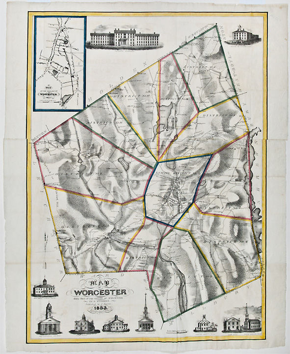
[Worcester]: Published by C. Harris, 1833. Lithographed folding map, printed on two sheets joined, period hand-colouring in outline. Inset map of the "Village of Worcester." Ten vignette views of buildings, including churches, schools, the "Antiquarian Hall" (i.e. American Antiquarian Society), town hall, the "Lunatic Hospital" and "House of Corrections." The scarcest and most decorative map of Worcester published in the 19th century.
"This 1833 map of the town of Worcester, Massachusetts, was printed by Pendleton's lithography. It is distinctive for its depiction of generalized relief and vegetation on the map and of churches and public buildings in the margins" (Ristow). The detail on the map is quite impressive, with hundreds of individual residences named and the locations of businesses identified. The hand coloured boundaries divide the county into twelve school districts. The printing of the map is exceptional, with the hachuring and views exquisitely rendered on stone by Pendleton's Lithography. Stebbins worked as a lawyer in South Brookfield, Massachusetts but was also a trained surveyor. Following work on this map, he was employed as a Civil Engineer by the Massachusetts Western Railroad. The map is rare, with no copies listed in the auction records. We can locate only the Harvard and University of Massachusetts copies.
Ristow, American Maps and Mapmakers, p. 289. Not in Rumsey or Phillips, A List of Maps of America.
Reviews
(Log in or Create an Account first!)
Details
- Seller
- Donald Heald Rare Books
 (US)
(US)
- Seller's Inventory #
- 25628
- Title
- A Map of Worcester Shire Town of the County of Worcester
- Author
- STEBBINS, Heman S. (1791-1838)
- Book Condition
- Used
- Quantity Available
- 1
- Publisher
- Published by C. Harris
- Place of Publication
- [Worcester]
- Date Published
- 1833
- Weight
- 0.00 lbs
- Bookseller catalogs
- North America; Pocket Maps;
Terms of Sale
Donald Heald Rare Books
All items are guaranteed as described. Any purchase may be returned for a full refund within 10 working days as long as it is returned in the same condition and is packed and shipped correctly.
About the Seller
Donald Heald Rare Books
Biblio member since 2006
New York, New York
About Donald Heald Rare Books
Donald Heald Rare Books, Prints, and Maps offers the finest examples of antiquarian books and prints in the areas of botany, ornithology, natural history, Americana and Canadiana, Native American, voyage and travel, maps and atlases, photography, and more. We are open by appointment only.
Glossary
Some terminology that may be used in this description includes:
- Vignette
- A decorative design or illustration placed at the beginning or end of a ...
This Book’s Categories

May the Fourth Be With You!
As the Star Wars franchise continues to grow, change, and churn out money-making film after film now under the control of Disney, we can bet that the desire to own Star Wars collectibles will also continue to grow. Check out our gallery of goodies from a galaxy far, far away...
Collecting and identifying signed letters and holographic documents
Many authors and other famous literary figures wrote and signed letters by hand, and you can find a great collection of them in the Biblio rare book room. See our great collection of handwritten letters and holographic documents