Description:
London: Printed for, & sold by Tho: Bowles print & map seller next ye. Chapter House in St. Pauls Church-Yard & Em. Bowen next ye King of Spain in S: Katherines, 1720. First Edition. Full Calf. Fine. First edition, first or second issue, of this fully and finely engraved road atlas of England and Wales, a smaller-format popular version of Ogilby's famous road atlas, originally published in two versions (both 1675), in folio editions. Small 4to (204 x 120mm): [6],273,[1]pp, comprising 54 county maps and associated suites of strip road maps in three or four columns over 273 plates engraved front and back by Emanuel Bowen. Contemporary Cambridge-style paneled calf, sympathetically rebacked, spine with five raised bands ruled in gilt, recent red morocco lettering piece gilt, all edges speckled red, plain period end papers. An all-together elaborate production, in Fine, clean, bright condition, each map fully and elaborately engraved by Emanuel Bowen and enhanced with little-known historical facts…
Read More Mapa De Los Ferro Carriles De La República Argentina Y De Los Paises Limítrofes. by Chavannes, José - 1892: Construido segun los datos é instrucciones suministrados por el Presidente de la Direccion Dor Don Luis Faraoz por el Ingeniero Geógrafo Don José Chavanne.
by Chavannes, José

Mapa De Los Ferro Carriles De La República Argentina Y De Los Paises Limítrofes.: Construido segun los datos é instrucciones suministrados por el Presidente de la Direccion Dor Don Luis Faraoz por el Ingeniero Geógrafo Don José Chavanne.
by Chavannes, José
- Used
- near fine
Buenos Aires, Dirección de Ferro Carriles Nacionales, 1892. Color topographical printed map in four parts of eighteen sections each, backed with linen. Scale: 1: 1,000,000. The map encompasses approximately 41° South latitude to approx. 20° S. latitude, and approx. 53° West longitude to a little beyond 73° W. latitude. This includes Chile along its entire western border, in some cases to the Pacific, and parts of Bolivia, Paraguay, and Uruguay. Railroad lines are shown as far south as Bahía Nueva in Chubut on the east coast and a bit inland from Valdivia (Chile) in the west; in the north Asunción is the farthest inland reach, and both completed and projected sections of the Transandine (Valparaiso to Buenos Aires) line are shown (the last tunnel was completed in 1909). Development of railways in the Argentine dates from 1857 and was mostly supported by private companies largely controlled in England, about 15% being owned and operated by the government. Produced following an investment crisis in 1890, this map may have been intended to encourage support of an already well-developed transportation system carrying the pastoral and agricultural products of Argentina's steadily developing export trade, which contributed greatly to maintaining the country's economic stability. Besides showing railways, the large scale on which this map was produced allows a comprehensive view of the country and its physical peculiarities. Dry rivers, mountain peaks, saline lakes, central plateaus, the Gran Chaco, countless rivers-- all are shown with the detail and elevations one expects from railroad survey expeditions. Each part consists of a single horizontal fold and nine vertical folds and attaches to its covers at the lower left section. Each section measures 8.25 x 12.25 inches. Each unfolded part of 18 sections measures 24.5 inches high by 74.5 inches wide; the entire map unfolds to eight feet two inches in height and six feet two inches wide. The four parts are bound in embossed green cloth covers printed in gold. Oval stamp of the DFCN near the cartouche. Despite a little old worming and a few minor stains, the map is handsome and brilliant. Stock#NS0156.
-
Seller
Independent bookstores
 (US)
(US)
- Book Condition Used - Near Fine
- Jacket Condition none
- Quantity Available 1
- Publisher Dirección de Ferro Carriles Nacionales
- Place of Publication Buenos Aires
- Date Published 1892
- Keywords 19th century Argentine Republic transporttion history railway railroad map

More Photos
Britannia depicta or Ogilby improv'd; being a correct coppy of Mr. Ogilby's Actual survey of all ye direct & principal cross roads in England and Wales: . . . And to render this—work universally usefull & agreeable, . . . are added . . . 1. A full & particular description & account of all the cities, borough-towns, towns-corporate . . . By Ino. Owen . . . 2. The arms of the peers of this realm . . . 3. The arms of all ye bishopricks & deanaries, . . . 4. The arms, & a succinct account of both universities & their respective colleges, . . . Lastly particular & correct maps of all ye counties of South Britain; with a—summary description of each county, . . . By Eman: Bowen engraver
by OGILBY, John (1600-1676); BOWEN, Emanuel (1693/4-1767)
- Used
- Fine
- first
- Condition
- Used - Fine
- Edition
- First Edition
- Binding
- Unknown
- Quantity Available
- 1
- Seller
-
Lancaster, Pennsylvania, United States
- Item Price
-
NZ$4,881.34
Show Details
Item Price
NZ$4,881.34

More Photos
Britannia: or a chorographical description of Great Britain and Ireland, together with the adjacent islands. Written in Latin by William Camden, Clarenceux, King at Arms: and translated into English, with additions and improvements. The second edition. Revised, digested, and published, with large additions, by Edmund Gibson, D. D. Rector of Lambeth; and now Bishop of Lincoln, and Dean of His Majesty's Chapel-Royal
by CAMDEN, William (1551-1623)
- Used
- Fine
- Condition
- Used - Fine
- Binding
- Unknown
- Quantity Available
- 1
- Seller
-
Lancaster, Pennsylvania, United States
- Item Price
-
NZ$6,144.19
Show Details
Description:
London: printed by Mary Matthews, for Awnsham Churchill, and sold by William Taylor, in Pater-Noster-Row, 1722. Full Calf. Fine. A pinnacle of English scholarship, the first comprehensive topographical survey of Great Britain, complete in two tall folio volumes, mainly printed in two numbered columns: [66]pp,cclxviii columns,[2]pp,696 columns; [2],697-1526 columns,[176, appendices, index and errata]pp, with copper-engraved frontispiece portrait of Camden, 10 plates of coins and antiquities, 51 folding or double-page uncolored maps (including 42 county maps and maps of north and south Wales, Scotland, Ireland, and "The Smaller Islands in the British Ocean) "all new engrav'd," additional engravings and woodcut illustrations in text. Contemporary Cambridge-style paneled calf (joints very neatly repaired), spine in seven compartments between raised bands, red morocco lettering pieces gilt; title pages in red and black. An unusually Fine set, original binding with handsome patina; pages bright, fresh and…
Read More Item Price
NZ$6,144.19
More Photos
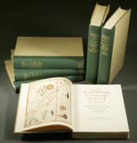
Mapping the Transmississippi West, 1540–1861,
by Wheat, Carl Irving (1892-1966)
- Used
- near fine
- Hardcover
- first
- Condition
- Used - Near Fine
- Edition
- First
- Binding
- Hardcover
- Quantity Available
- 1
- Seller
-
Fort Worth, Texas, United States
- Item Price
-
NZ$4,630.45
Show Details
Description:
From the Spanish discovery to the opening of the Civil War5 volumes in 6. Volume One: The Spanish Entrada to the Louisiana Purchase 1540-1804 xiv+264 pages with color frontispiece map and 275 maps (many folding) and index; Volume Two: From Lewis and Clark to Fremont 1804-1845 xiii+281 pages with colored frontispiece map, 143 additional maps (some folding) and index. Volume Three: From the Mexican War to the Boundary Surveys 1846-1854 xiii+349 pages with colored frontispiece map, 322 additional maps and index; Volume Four: From the Pacific Railroad Surveys to the Onset of the Civil War 1855-1860 xiii+260 pages with color frontispiece map, an additional 127 maps (some folding) and index; Volume Five From the Civil War to the Geological Survey, Part One: xviii+222 pages with color frontispiece map and an additional 152 maps; Volume Five From the Civil War to the Geological Survey, Part Two: [223]-487 pages with 124 maps and index. Folio (14 1/2" x 10 1/2") bound in quarter green leather with gilt…
Read More Item Price
NZ$4,630.45
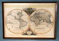
Mappe-Monde Geo-Hydrographique, ou Description Generale du Globe Terrestre et Aquatique en Deux Plans-Hemispheres; ou Sont Exactement Remarquees en General Toutes Les Parties De La Terre et de L'Eau, Suivant les Relations Les Plus Nouvelles. Par le S. Sanson, Geographe Ordinaire du Roy. 1684.
by Jaillot (Alexis-Hubert)
- Used
- Condition
- Used
- Binding
- Unknown
- Quantity Available
- 1
- Seller
-
Sidney, British Columbia, Canada
- Item Price
-
NZ$5,893.30
Show Details
Description:
Paris, 1684. . Large double-hemisphere map, 36 x 25 inches (framed: 38 x 26.5 inches). Attractively coloured, decorative cartouche and embellishments. Modest wear at fold, some light marginal stains, an attractive copy. This map has been mounted on cardboard via an unknown process, but there is no evidence of damage. This looks to be Shirley's state 4 of the first plate, with Cordier's name beneath the left hemisphere (Cordier Sculp.) and a date of 1684. The first plate exists in four states, dated 1674, 1679, 1681, and 1684 (this one). An enlarged version of a previous map by Nicolas Sanson, beautiful and striking. Wheat 65, citing the 1684 edition.
Item Price
NZ$5,893.30
More Photos
Observations on the Passage to India: Through Egypt, and Across the Great Desert; With Occasional Remarks On The Adjacent Countries, And Also Sketches Of The Different Routes.
by CAPPER, James
- Used
- first
- Condition
- Used
- Binding
- Unknown
- Quantity Available
- 1
- Seller
-
Beverly Hills, California, United States
- Item Price
-
NZ$4,630.45
Show Details
Description:
London: For W. Faden, J. Robson, and R. Sewell, 1783. First edition. Quarto (10 x 7 3/4 inches; 255 x 197 mm). xx, 110, [4, blank] pp. With two folding maps, including frontispiece. Newer half calf over original marble paper boards. Contemporary red morocco spine label. Label lettered in gilt. Spine stamped in gilt. New endpapers. Previous owner's bookplate on front pastedown. Some mild foxing throughout. Previous owner's neat errata corrections in blue ink. Overall a very good copy. James Capper was a British army officer and meteorologist... "He was educated at Harrow School and served thereafter in His Majesty's Train of Artillery in the East Indies, first as a soldier cadet and later as an officer. He was then for a while a free merchant in Bengal before becoming in 1768 a captain in the Madras army and in 1769 senior writer for the presidency of Bengal. He was repatriated on grounds of ill health after becoming unwell on active service but returned to India in 1773, when appointed the East…
Read More Item Price
NZ$4,630.45
![Stockton Looking East. San Joaquin County, Cal. Original Bird's Eye View. [LITHOGRAPH]](https://d3525k1ryd2155.cloudfront.net/h/929/544/257544929.0.m.jpg)
Stockton Looking East. San Joaquin County, Cal. Original Bird's Eye View. [LITHOGRAPH]
- Used
- Condition
- Used
- Binding
- Unknown
- Quantity Available
- 1
- Seller
-
San Francisco, California, United States
- Item Price
-
NZ$5,472.35
Show Details
Description:
San Francisco: Lithographed by W. W. Elliott Lithograph. No date (c.1890). 24x38 inches. Lithographed in black on white. Top border edge just a bit rough, but a fine crisp copy. A magnificent bird's-eye view showing all of the city of Stockton, California and the surrounding country. All of the streets and roads are labeled. Surrounding the view are 26 insets showing public and commercial buildings. Includes promotional text for the city as well as an index of significant buildings and places, keyed by number to the view. At the bottom border, "Compliments of E.A. Crennan & Co., Real Estate Auctioneers, Stockton, California." W.W. Elliott is best known for his views in a number of the county histories produced in the 1870's and 1880's. Unlike many lithographers of similar views of that period, Elliott had a knack for artistic shading which gave his images a wonderful quality of depth and clarity. This lithograph is quite scarce and is rarely offered It is not mentioned in…
Read More Item Price
NZ$5,472.35

More Photos
Le nouveau et curieux Atlas Geographique et historique...
by Chiquet (Jacques) [Antoine Menard].
- Used
- Hardcover
- Condition
- Used
- Binding
- Hardcover
- Quantity Available
- 1
- Seller
-
Sidney, British Columbia, Canada
- Item Price
-
NZ$3,788.55
Show Details
Description:
Paris: chez Chereanau, [1719].. Oblong small 4to. Full vellum with ties. Wear at edges, chip from fore-edge of lower front cover,blank end leaves are heavily annotated and written-upon in 18th & 19th century hands. Old stains to margins and a few maps, old paper-tape repairs to the verso of the Asia map, but generally very good. Engraved allegorical title page, 3 plates (two of globes), and 24 maps opposite explanatory text in French. 23 maps have contemporary hand-colouring in outline; a couple have attractively coloured cartouches. The Globe Terrestre map, of two hemispheres, is holed, slightly affecting the title. The map of North America shows California as an island. This is the second or third edition of this atlas, originally by Antoine Menard, first published by Chiquet in [1711 & 1713], with most of the maps dated 1709-1711. In this 1719 edition Chiquet has removed Menard's name entirely; on many of the maps (such as L'Amerique Septentrionale) he has changed it to his own name and altered…
Read More Item Price
NZ$3,788.55

More Photos
Catalogue des Cartes Géographiques, Topographiques & Marines, de la Bibliothèque du Prince Alexandre Labanoff de Rostoff, a Saint-Pétersbourg. Suivi d'une Notice de Manuscrits
- Used
- very good
- Hardcover
- first
- Condition
- Used - Very Good
- Edition
- 1st Edition
- Binding
- Hardcover
- Quantity Available
- 1
- Seller
-
Kraków, Poland
- Item Price
-
NZ$3,963.40
Show Details
Description:
Paris: Firmin Didot, 1823 8vo (20 x 13.2 cm), VIII, 494, [2] pp, half chagrin over marbled boards, with original wrappers bound in (slightly foxed, blind collector stamps on the title and the first page). This is the catalog of the map collection of Duke Aleksandr Lobanov-Rostovsky (1788-1866), a Russian general and diplomat. The catalog was authored by the Duke himself, with assistance from Charles Piquet. This edition is one of the 230 copies privately printed by Firmin Didot.
Item Price
NZ$3,963.40

More Photos
L’Utrecht suivant les nouvelles observations de Messrs. de l’Academie des Sciences etc. Augmentées de nouveau.
by Covens, Johannes et Cornelis Mortier
- Used
- Condition
- Used
- Quantity Available
- 1
- Seller
-
Tuebingen, Germany
- Item Price
-
NZ$4,083.75
Show Details
Description:
Engraved and partially hand-coloured map with nice figurative cartouche mounted on wood, backside lined with blue paste paper with impressed decoration (= complete). Oblong folio (300 x 223 mm). All pieces loosely contained in contemporary wooden box with a sliding lid with manuscript title "Utrecht" on top. A very early example of this kind of game, and hard to find complete and in very good overall condition.
Item Price
NZ$4,083.75
More Photos
A complete genealogical, historical, chronological and geographical atlas: Lavoisne Atlas
by C V Lavoisne
- Used
- very good
- Hardcover
- Condition
- Used - Very Good
- Jacket Condition
- none
- Edition
- 2nd
- Binding
- Hardcover
- Quantity Available
- 1
- Seller
-
Dixon, Illinois, United States
- Item Price
-
NZ$4,209.50
Show Details
Description:
C V Lavoisne; C Gros; Jehoshaphat Aspin; E PaguenaudA complete genealogical, historical, chronological and geographical atlas; being a general guide to history, both ancient and modern: exhibiting an accurate account of the origin, descent, and marriages of all the royal families . the whole forming a complete system of history and geographyPhiladelphia, Published by M. Carey and Son; printed by T.H. Palmer, 1820-01-01. 2nd American ed., carefully rev. Hardcover. Good. Second American edition, published in the same year as the first American edition. Folio, 46 x 34 cm, (17 1/2 x 11 7/8 inches). Bound with contemporary gilt letter spine over boards. Good condition for being an 1820's copy. Beautiful marbled paper over boards both outside and inside covers. Original spine still holding except for a split at the bottom and a small chunk missing. See Pic. Sought after John Melish United States map in the back. Some paper loss on the title page with some small holes. Maps are in very good condition with a…
Read More Item Price
NZ$4,209.50

More Photos
The Sky and the Forest
by Forester, C.S
- Used
- very good
- Hardcover
- first
- Condition
- Used - Very Good
- Jacket Condition
- Very Good
- Edition
- First Edition
- Binding
- Hardcover
- Quantity Available
- 1
- Seller
-
Salem, Oregon, United States
- Item Price
-
NZ$58.75NZ$29.38Save NZ$17.44!
Show Details
Description:
C.S. Forester: The Sky and the Forest. Little, Brown and Company, Boston. Stated First Edition First Printing Thus August, 1948. Cover price $2.75. Used. VG BOOK/VG UNCLIPPED DUST JACKET. A story of a central Africa. By C.S. Forester, author of the Admiral Hornblower series.
Item Price
NZ$58.75NZ$29.38
Save NZ$17.44
!

More Photos
Plat Book: Pierce County, Wisconsin
by Rhame, A. E
- Used
- Fine
- Paperback
- Condition
- Used - Fine
- Binding
- Paperback
- Quantity Available
- 1
- Seller
-
Woodruff, Wisconsin, United States
- Item Price
-
NZ$78.57
Show Details
Description:
1930. Soft Cover. Fine. Unpaginated. Tan colored book is in Fine condition, no sign of wear.
Item Price
NZ$78.57
![Alaska and Klondike Region; [With inset of Klondike Region on the Upper Yukon detail] [From an...](https://d3525k1ryd2155.cloudfront.net/h/062/537/1339537062.0.m.jpg)
Alaska and Klondike Region; [With inset of Klondike Region on the Upper Yukon detail] [From an atlas, "Gazetteer of Alaska and Yukon Region " pp. 105 and 106]
by Miller, J. Martin
- Used
- very good
- Condition
- Used - Very Good
- Edition
- Unknown
- Quantity Available
- 1
- Seller
-
Sebastopol, California, United States
- Item Price
-
NZ$65.67
Show Details
Description:
Chicago: J. Martin Miller, 1899. Unknown. Map. Very Good. [Map copyright 1899, printing date of Atlas later] [19.875x15.125in]; Colored map of Alaska with steamer routes from Portland and Seattle, insets of the Klondike Region on the Upper Yukon and Western portion of Aleutian Islands; On verso index of places and names with two large black and white images; Age toning to all edges, water stain marks on bottom, slight printing offset of colors, small chips and closed tears to lower edge;.
Item Price
NZ$65.67

Zemepis Sveta - Monsunova Asie
by De La Blache, P. Vidal; Gallois, L
- Used
- Hardcover
- Condition
- Used - Very Good Condition
- Jacket Condition
- No Dust Jacket
- Binding
- Hardcover
- Quantity Available
- 1
- Seller
-
Oak Point, Texas, United States
- Item Price
-
NZ$101.03
Show Details
Description:
Aventinum, Prague, Czechoslovakia, 1931. Hardcover. Very Good Condition/No Dust Jacket. Text entirely in Czech. Geography book on Asia with numerous photographs and maps. 1930 edition also available. Size: 4mo - over 9 3/4" - 12" tall. 400 pp. Pages are yellowed, but are tight and clean. Moderate shelfwear along the spine. Corners are lightly bumped. Quantity Available: 1. Shipped Weight: 3-5 pounds. Category: Travel & Places; Non-English Language::Czech; Pictures of this item not already displayed here available upon request. Inventory No: 001228. . Additional shipping charges may apply.
Item Price
NZ$101.03

Last Tales
by Dinesen, Isak
- Used
- very good
- Hardcover
- first
- Condition
- Used - Very Good
- Jacket Condition
- Good+
- Edition
- First Edition
- Binding
- Hardcover
- Quantity Available
- 1
- Seller
-
Salem, Oregon, United States
- Item Price
-
NZ$202.06NZ$101.03Save NZ$60.00!
Show Details
Description:
Dinesen, Isak: Last Tales, A Collection of Twelve New Tales of Compelling Beauty 1957, Random House. First Edition. Stated First Printing Thus. Used. Very Good/Good+ original red dust jacket, price-clipped. Jacket states 11/57 on front flap. 5 3/4 X
Item Price
NZ$202.06NZ$101.03
Save NZ$60.00
!

Zemepis Sveta - Monsunova Asie
by De La Blache, P. Vidal; Gallois, L
- Used
- Hardcover
- Condition
- Used - Very Good Condition
- Jacket Condition
- No Dust Jacket
- Binding
- Hardcover
- Quantity Available
- 1
- Seller
-
Oak Point, Texas, United States
- Item Price
-
NZ$101.03
Show Details
Description:
Aventinum, Prague, Czechoslovakia, 1930. Hardcover. Very Good Condition/No Dust Jacket. Text entirely in Czech. Geography book on Asia with numerous photographs and maps. 1931 edition also available. Size: 4mo - over 9 3/4" - 12" tall. 400 pp. Pages are yellowed, but are tight and clean. Moderate shelfwear along the spine. Corners are lightly bumped. Quantity Available: 1. Shipped Weight: 3-5 pounds. Category: Travel & Places; Non-English Language::Czech; Pictures of this item not already displayed here available upon request. Inventory No: 001227. . Additional shipping charges may apply.
Item Price
NZ$101.03

The Adventure of Wrangel Island
by Vilhjalmur Stefansson
- Used
- good
- Hardcover
- first
- Condition
- Used - Good
- Jacket Condition
- No DJ Included
- Edition
- First Edition
- Binding
- Hardcover
- Quantity Available
- 1
- Seller
-
Salem, Oregon, United States
- Item Price
-
NZ$210.29NZ$105.15Save NZ$62.44!
Show Details
Description:
The Adventure of Wrangel Island, Alaska (1925 Macmillan 1st Edition) HISTORY OF ALASKA. EXLIB. Good Condition/ No DJ included. Fold-out map affixed to binding at the back of the book has never been opened. The story of the (unsuccessful) attempted colonization of Wrangel Island Alaska. 413 pages plus appendix, Index. Titling is still bright. A clean, solid copy. Scarce.
Item Price
NZ$210.29NZ$105.15
Save NZ$62.44
!

Seven Pillars Of Wisdom, A Triumph
by Lawrence, T.E
- Used
- good
- Hardcover
- first
- Condition
- Used - Good
- Jacket Condition
- No DJ Included
- Edition
- First American Edition
- Binding
- Hardcover
- Quantity Available
- 1
- Seller
-
Salem, Oregon, United States
- Item Price
-
NZ$210.39NZ$105.20Save NZ$62.47!
Show Details
Description:
T.E. Lawrence. SEVEN PILLARS OF WISDOM, A TRIUMPH. AUTOBIOGRAPHY. Privately Printed, 1926. First Published for general circulation 1935. First American Edition. States MCMXXXVI on the title page. Doubleday, Doran & Company, Inc. Garden City, NY. GOOD CONDITION/ NO DUST JACKET IS INCLUDED. 672 pages, indexed. Beige buckram boards. Spine has darkened a bit. 6 7/8 X 9 ½.
Item Price
NZ$210.39NZ$105.20
Save NZ$62.47
!

North America from the Best Authorities, Russell, ca.1800
by Russell
- Used
- Condition
- Used
- Quantity Available
- 1
- Seller
-
Plymouth, Devon, United Kingdom
- Item Price
-
NZ$42.18
Show Details
Description:
Russell, J. : A General Map of North America from the Best Authorities. Nd but ca.1800. From "A New Geographical, Historical and Commercial Grammar and Present State of Several Kingdoms of the World." Copper engraving. Size approx 200 x 230mm. Two neat folds. Some age colouring to edges, otherwise very clean and bright.
Item Price
NZ$42.18

Asia from the Best Authorities, Russell, ca.1800
by Russell
- Used
- Condition
- Used
- Quantity Available
- 1
- Seller
-
Plymouth, Devon, United Kingdom
- Item Price
-
NZ$42.18
Show Details
Description:
Russell, J. : Asia from the Best Authorities. Nd but ca.1800. From "A New Geographical, Historical and Commercial Grammar and Present State of Several Kingdoms of the World". Copper engraving. Size approx 200 x 230mm. Two neat folds. Some age colouring to edges, otherwise clean and bright. Includes Arabia, India, Borneo, Japan, China and eastern Russia.
Item Price
NZ$42.18