Click for full-size.
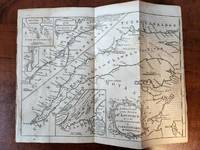
A New Chart of the St. Lawrence from the Island of Anticosti to Lake Ontario
by Kitchen, T [Thomas]
- Used
- Very Good
- first
- Condition
- Very Good/No Jacket
- Seller
-
Ottawa, Ontario, Canada
Payment Methods Accepted
About This Item
Londom: The London Magazine, 1759. Map. Very Good. No Binding. 1st Edition. Overall size 10x7.25 in., plus approx. 1/4 in. border on all four sides. From an engraving for the London Magazine, September 1759 edition. Originally folded into 4 panels. Disbound, but retaining the complete map. Includes three inserts: The Traverse or Passage from Cape Torment into the South Channel of Orleans Isle; A Continuation of the River St. Lawrence from Quebec to Lake Ontario; The Seven Islands. Light discoloration in places, but overall a nice clean example..
Reviews
(Log in or Create an Account first!)
Details
- Seller
- R. Hart Books
 (CA)
(CA)
- Seller's Inventory #
- 182868
- Title
- A New Chart of the St. Lawrence from the Island of Anticosti to Lake Ontario
- Author
- Kitchen, T [Thomas]
- Book Condition
- Used - Very Good
- Jacket Condition
- No Jacket
- Edition
- 1st Edition
- Publisher
- The London Magazine
- Place of Publication
- Londom
- Date Published
- 1759
- Weight
- 0.00 lbs
- Keywords
- MAP CANADA ST. LAWRENCE RIVER QUEBEC NEW ENGLAND NOVA SCOTIA CARTOGRAPHY
- Bookseller catalogs
- Canadiana;
Terms of Sale
R. Hart Books
Books will be reserved for a maximum of 5 days; returns may be made within 10 days by prior arrangement, pre-paid, if not as described.
About the Seller
R. Hart Books
Biblio member since 2004
Ottawa, Ontario
About R. Hart Books
R Hart Books offers quality used and collectible books via the Internet, with an emphasis on Military History.
Frequently asked questions
This Book’s Categories

Collecting the Civil Rights Movement
The Civil Rights Movement of the 1960s and ’70s was an explosive time in American history, and it inspired explosive literature. From Malcolm X to Martin Luther King, Jr., browse some of the most collectible books from and about that era.

Collecting Arkham House
Learn about collecting the iconic horror and fantasy publisher that produced books by the likes of Ray Bradbury, August Derleth and H. P. Lovecraft.
