Click for full-size.
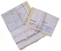
Persian Gulf | ONC-H-6/7. Operational navigation chart.St Louis, Aeronautical chart and information center, United States Air Force, 1969. Two copies of two folding maps colour printed on both sides of a sheet of silk (103 x 78.5 cm) on a scale of ca. 1:1,000,000. The two maps (ONC-H-6 & ONC-H-7) show one continuous area.
by [MAP - ARABIAN GULF]. Aeronautical chart and information center
- Used
- Condition
- See description
- Seller
-
't Goy-houten, Netherlands
Payment Methods Accepted
About This Item
Rayon pilot's map of the Arabian Gulf region focusing on the Trucial States (modern UAE), Qatar, Bahrain, Oman, Iran and Saudi Arabia, including main oil installations. Items of specific interest to aircraft, such as airfields and even seaplane bases, are particularly listed. Warnings to stay within the specific flying routes while in Iran are placed on multiple locations. While the map depicts a continuous area on both side on of one sheets, it actually consist of two maps, originally published separately. We here include two copies so the whole area can be displayed. The maps are reproduced after the third and fourth edition.In very good condition.
Reviews
(Log in or Create an Account first!)
Details
- Bookseller
- Antiquariaat FORUM BV
 (NL)
(NL)
- Bookseller's Inventory #
- L95DV18L9VQZ
- Title
- Persian Gulf | ONC-H-6/7. Operational navigation chart.St Louis, Aeronautical chart and information center, United States Air Force, 1969. Two copies of two folding maps colour printed on both sides of a sheet of silk (103 x 78.5 cm) on a scale of ca. 1:1,000,000. The two maps (ONC-H-6 & ONC-H-7) show one continuous area.
- Author
- [MAP - ARABIAN GULF]. Aeronautical chart and information center
- Book Condition
- Used
- Keywords
- [80CBADC1D9E8] CARTOGRAPHY & EXPLORATION|[80CBADC1D9E8] CARTOGRAPHY & EXPLORATION -> [D1FD79398985] Atlases, Charts, Maps & Globes|[G8L0P27N9XV3] MIDDLE EAST & ISLAMIC WORLD|[G8L0P27N9XV3] MIDDLE EAST & ISLAMIC WORLD -> [G8L0PL716DJU] Arabian Peninsula &
Terms of Sale
Antiquariaat FORUM BV
30 day return guarantee, with full refund including original shipping costs for up to 30 days after delivery if an item arrives misdescribed or damaged.
About the Seller
Antiquariaat FORUM BV
Biblio member since 2014
't Goy-houten
About Antiquariaat FORUM BV
After its foundation at Utrecht in 1970 by Sebastiaan Hesselink, now an internationally recognized expert in the world of rare books, manuscripts & prints, Antiquariaat FORUM soon found place as a widely accepted member of the antiquarian book trade. We carry general stock in old and rare books, with special emphasis on the subjects of Travel, Natural History, Art and Architecture, Children's Books, Bindings, Coloured Plate Books, Emblem Books, Gastronomy, Medicine, Music, Science, 16th Century, Incunables, and Illuminated Manuscripts. All our books are in fine condition, and usually in original bindings.

Collecting and identifying signed letters and holographic documents
Many authors and other famous literary figures wrote and signed letters by hand, and you can find a great collection of them in the Biblio rare book room. See our great collection of handwritten letters and holographic documents

The Great Formosa Hoax
George Psalmanazar played a grand prank in 1703, pretending to be a resident of the island of Formosa. His book took London by storm. Learn more...
