
Click for full-size.
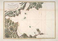
PLAN DE LA BAIE DE CASTURIES SITUEÉ SUR LA CÔTE ORIENTALE DE TARTARIE,: par 51 21' o" de Latitude Nord et 139 39' o" de Longitude Orientale du Méridien de Paris, levé en Juillet 1787. PAR S.NE BERNIZET sous l'inspection de M. de la Pérouse.
by LA PÉROUSE, Jean Francois de Galaup.Engraved by L. AUBERT
- Used
- Condition
- See description
- Seller
-
London, United Kingdom
Payment Methods Accepted
About This Item
Atlas Du Voyage De La Pérouse. Paris: L'Imprimerie de la Republique., 1797.. From the Voyages of La Pérouse who set sail from France in 1785 to continue the discoveries of Captain Cook. He was shipwrecked in 1788 but his narrative, maps, and views survived and were published in 1797. An attractive sea chart showing a bay at the coast of Eastern Tartary. Relief shown by hachures; depths by soundings. This is how this part of La Pérouse's journey was described in a diary: 'On 11 August, they reached the southwestern point of Sakhalin Island, which La Pérouse named Cap Crillon (Mys Kril'on). The ships anchored near Mys Kril'on and Vaujuas went ashore where he met more Ainu people, some of whom also visited the ship. The ships began to sail through the strait the next day. La Pérouse called it Canal de Castries but it would later be called La Perouse Strait.' Copper engraving. Hand coloured. Very good condition. Faint vertical waterstains. Some very slight browning to lower margin. Good margins. Size: 68 x 49 cm. (27 x 19½ inches)
Reviews
(Log in or Create an Account first!)
Details
- Bookseller
- Peter Harrington
 (GB)
(GB)
- Bookseller's Inventory #
- 55877
- Title
- PLAN DE LA BAIE DE CASTURIES SITUEÉ SUR LA CÔTE ORIENTALE DE TARTARIE,
- Author
- LA PÉROUSE, Jean Francois de Galaup.Engraved by L. AUBERT
- Book Condition
- Used
- Place of Publication
- Atlas Du Voyage De La Pérouse. Paris: L'Imprimerie de la Republique.
- Date Published
- 1797.
Terms of Sale
Peter Harrington
All major credit cards are accepted. Both UK pounds and US dollars (exchange rate to be agreed) accepted. Books may be returned within 14 days of receipt for any reason, please notify first of returned goods.
About the Seller
Peter Harrington
Biblio member since 2006
London
About Peter Harrington
Since its establishment, Peter Harrington has specialised in sourcing, selling and buying the finest quality original first editions, signed, rare and antiquarian books, fine bindings and library sets. Peter Harrington first began selling rare books from the Chelsea Antiques Market on London's King's Road. For the past twenty years the business has been run by Pom Harrington, Peter's son.
Glossary
Some terminology that may be used in this description includes:
- A.N.
- The book is pristine and free of any defects, in the same condition as ...

Using and Collecting Bookmarks
Bern Marcowitz warns against paperclips and other inappropriate page-savers, and offers a bit of advice on using and collecting bookmarks.

The Great Formosa Hoax
George Psalmanazar played a grand prank in 1703, pretending to be a resident of the island of Formosa. His book took London by storm. Learn more...
