Description:
New York: J.H. Colton & Co, 1855. 1855 edition. Original Cloth. Good. Full-color engraved map, colored by hand, scrollwork border on all sides, opens to 25" x 29"; repairable separations at the intersections of several folds. Folds into red cloth case with embossed all-over design on both covers, gilt lettering on front. 5.5" x 3.75" [OCLC locates three holdings of this edition: Grinnell Col, U Iowa, Stanford U. Decker 23:225--1870 edition.].
RECUEIL DE CARTES GÉOGRAPHIQUES, PLANS, VUES ET MÉDAILLES de L'Ancienne Grece, Relatifs au Voyage du jeune Anacharsis; Précédé d'une Analyse Critique des Cartes. Nouvelle Édition. by BARBIE DU BOCAGE, Jean Denis - 1798
by BARBIE DU BOCAGE, Jean Denis

RECUEIL DE CARTES GÉOGRAPHIQUES, PLANS, VUES ET MÉDAILLES de L'Ancienne Grece, Relatifs au Voyage du jeune Anacharsis; Précédé d'une Analyse Critique des Cartes. Nouvelle Édition.
by BARBIE DU BOCAGE, Jean Denis
- Used
- Hardcover
Paris: De l'Imprimerie de Didot Jeune, L'An septième (1798-1799)., 1798 110 pages - (1ff) - 39 des 40 planches indiquées dans la Table. La planche 1 (Carte Générale de la Grèce avec ses Colonies) est absente. D'après Brunet, cette planche n'a été publié qu'en 1811. Une planche additionnelle, non-indiquée dans la Table, est présente, soit la 19bis (Les deux frontons du Parthénon, dans l'état où ils se trouvoient en 1674). Les plats sont détachés, un nouvelle reliure serait souhaitable. Réparation à la page titre. Autrement, les pages intérieures et les planches sont en très bonne condition. Certaines cartes ont des contours coloriés à la main. Erreur de numérotation à la page 104 (numéroté 102 au lieu de 104).
-
Bookseller
Independent bookstores
 (CA)
(CA)
- Format/Binding Hardcover
- Book Condition Used - Condition Satisfaisante
- Quantity Available 1
- Binding Hardcover
- Publisher De l'Imprimerie de Didot Jeune, L'An septième (1798-1799).
- Place of Publication Paris
- Date Published 1798
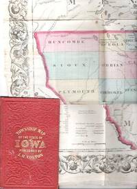
COLTON'S TOWNSHIP MAP OF THE STATE OF IOWA: Compiled from the United Statees Surveys & other Authentic Sources.; Drawn by George W. Colton. Engraved by J.M. Atwood
by Iowa
- Used
- good
- Condition
- Used - Good
- Edition
- 1855 edition
- Binding
- Unknown
- Quantity Available
- 1
- Seller
-
Roosevelt, New Jersey, United States
- Item Price
-
NZ$507.60
Show Details
Item Price
NZ$507.60
More Photos
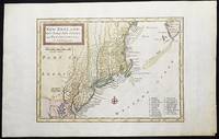
New England, New York, New Jersey, and Pensilvania &c. by H. Moll Geographer
by Moll, Herman
- Used
- near fine
- Condition
- Used - Near Fine
- Binding
- Unknown
- Quantity Available
- 1
- Seller
-
Lansdowne, Pennsylvania, United States
- Item Price
-
NZ$785.09
Show Details
Description:
London: H. Moll, 1708. Near Fine. 1 sheet 232 x 267 mm. (image is 180 x 254 mm.) Hand-colored copper engraved map. This is Herman Moll's earliest map of New England, published in the first edition of John Oldmixon's The British Empire in North America in 1708. List of 19 towns in lower right-hand corner. New Jersey is shown as East New Jersey and West New Jersey. Pennsylvania still contains the Lower Counties, which separated and became Delaware in 1704. On the west side of the Susquehanna River is shown "The Present Sasquahana Indian Fort." In Near Fine Condition: light creasing; clean and bright.
Item Price
NZ$785.09

More Photos
Viaggio a Pompei a Pesto e di ritorno ad Ercolano en a Pozzuoli
by ROMANELLI, Domenico
- Used
- very good
- Paperback
- Condition
- Used - Very Good
- Binding
- Paperback
- Quantity Available
- 1
- Seller
-
Cuernavaca, Mexico
- Item Price
-
NZ$744.48
Show Details
Description:
Napoli, Angelo Trani, 1817En 8vo. 2 Vol. V.I: 288pp, 2 folding fmaps of Pompei and Fondona Pianta.; V. II: 276pp + engraving and one folding map. Original publishers paperback in an elegant full calf box. Hand made paper, uncut. Vol I with old worm marks in several pages (minor text damage).The edition was updated with all of the new disvoveries, a very precise map of Pompey and of the voyage to Pozzuol.Romanelli, Domenico (1756-1819) Abbé. – was an Italian historian and archaeologist. Curator of the Public Library in Napoli.Nice set.
Item Price
NZ$744.48

More Photos
State of the Naton.
by Sollod, Ellen.
- Used
- Signed
- Condition
- Used
- Edition
- One-of-a-Kind
- Binding
- Unknown
- Quantity Available
- 1
- Seller
-
Hoover, Alabama, United States
- Item Price
-
NZ$676.80
Show Details
Description:
Seattle, Washington:: Ellen Sollod,, 2020.. One-of-a-Kind. 12.5" x 9.5" x .75" closed,12.5" x 19" open. Altered book: "Hammond New Supreme World Atlas" published by Garden City Books, 1953. Signed and dated by the artist. Ellen Sollod: "All the states in the union featured in the atlas are torn and rearranged to call attention to the fractured state of the nation in 2019. Black and white photographs of particular sites, previously in the index, have been collaged into the body of the book. It is a call-to-action to knit our country together.
Item Price
NZ$676.80

More Photos
NUOVA PIANTA DI FIRENZE CON L'INDICAZIONE DEI TRE DISTANTI SATI E GIRI DI Mura Che Ebbe in Diferenti Epoche. Publicata Con Privilegio Imperiale e Reale.
by FLORENCE - FIRENZE
- Used
- very good
- Condition
- Used - Very Good
- Binding
- Unknown
- Quantity Available
- 1
- Seller
-
Tel-Aviv, Israel
- Item Price
-
NZ$592.20
Show Details
Description:
Firenze: Nella Stamperia Del Giglio, 1818. Original Cardboard. Very Good. 8vo. 28pp text and a folding map of FIRENZE 67 x 55 cm. Small 8 vo. Minimal outside wear . Some expert repair to map. A few small stains on the verso of map. OTHERWISE A VERY GOOD AND CLEAN COPY.. A RARE AND BEAUTIFUL FLAN OF FIRENZE.
Item Price
NZ$592.20
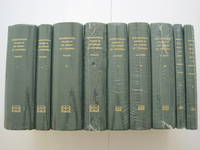
A List of Geographical Atlases in the Library of Congress with Bibliographical Notes : 9 volumes, complete [new, in publisher's shrinkwrap]
by Phillips, Philip Lee [Vols 1-4]; & Clara Egli LeGear Le Gear [vols 5-9]
- New
- Hardcover
- first
- Condition
- New
- Jacket Condition
- in publisher's shrinkwrap
- Edition
- First Martino printing
- Binding
- Hardcover
- Quantity Available
- 1
- Seller
-
Henderson, Nevada, United States
- Item Price
-
NZ$802.85
Show Details
Description:
Staten Island, New York: Maurizio Martino Publisher, 1995. SEE PHOTO. 9 volumes, complete. BRAND NEW HARDCOVERS in perfect condition. STILL SEALED in the publisher's clear plastic SHRINKWRAP. NO rubbing. NO fading. Bright, clean, square and tight. Sharp corners. NO owner's name or bookplate. NOT a remainder. Fresh and crisp -- obviously never read. The standard reference, complete in 9 volumes. Vols. 1-4 by Philip Lee Phillips. No date (but 1995, First Martino printing "strictly limited to 100"). Reprint of the 1909-1920 Library of Congress originals. Vols 5-9 by Clara Egli Le Gear. No date (but 1996, First Martino printing "strictly limited to 150"). Reprint of the 1958-1992 Library of Congress originals, in continuation of volumes 1-4 by Philip Lee Phillips. These 9 volumes fully describe thousands of atlases, including imprint, collation, details of publication, measurements, content, typographical and numbering errors, comparisons with foreign and…
Read More Item Price
NZ$802.85

More Photos
Geographical, Historical, and Commercial Grammar Kingdoms & Maps of the World 1792
by William Guthrie
- Used
- fair
- Hardcover
- Condition
- Used - Fair
- Binding
- Hardcover
- Quantity Available
- 1
- Seller
-
Humboldt, Tennessee, United States
- Item Price
-
NZ$846.00
Show Details
Description:
1792. leather. Fair. Photo Gallery Original Edition -RARE!- 1792 -Thirteenth Edition- Corrected (First Edition was about 1770) Publisher-Printing Location: Printed for Charles Dilly, etc. London Author: William Guthrie, the Astronomical Part by James Ferguson Date: 1792 Size and Page Count: 5.5 X 8.5 Tall; 910 Pages Condition: -Fair- Leather Bound that has ancient repairs with leather on hinge and spine, corners heavy wear, a few pages have stain spots tears on edges, Foxing, heavier on front pages; text block Good, many fold out maps that extend at their fold past the paper text block that have wear and tears from storage.(over 220 years) Illustrations Information: 15 foldout MAPS and Hundreds of Tables and Charts -------- An excellent opportunity for the collector, researcher or historian --------- Articles and Information: Includes: Title page, advertisement (bibliography of changes to each edition up to this one, mentions the 13 Colonies), Preface(6 pages), Contents, Introduction (pages 1 to 58),…
Read More Item Price
NZ$846.00
COLTON'S TOWNSHIP MAP OF THE STATE OF IOWA: Compiled from the United Statees Surveys & other Authentic Sources.; Drawn by George W. Colton. Engraved by J.M. Atwood
by Iowa
- Used
- good
- Condition
- Used - Good
- Edition
- 1855 edition
- Binding
- Unknown
- Quantity Available
- 1
- Seller
-
Roosevelt, New Jersey, United States
- Item Price
-
NZ$507.60
Show Details
Description:
New York: J.H. Colton & Co, 1855. 1855 edition. Original Cloth. Good. Full-color engraved map, colored by hand, scrollwork border on all sides, opens to 25" x 29"; repairable separations at the intersections of several folds. Folds into red cloth case with embossed all-over design on both covers, gilt lettering on front. 5.5" x 3.75" [OCLC locates three holdings of this edition: Grinnell Col, U Iowa, Stanford U. Decker 23:225--1870 edition.].
Item Price
NZ$507.60
More Photos
New England, New York, New Jersey, and Pensilvania &c. by H. Moll Geographer
by Moll, Herman
- Used
- near fine
- Condition
- Used - Near Fine
- Binding
- Unknown
- Quantity Available
- 1
- Seller
-
Lansdowne, Pennsylvania, United States
- Item Price
-
NZ$785.09
Show Details
Description:
London: H. Moll, 1708. Near Fine. 1 sheet 232 x 267 mm. (image is 180 x 254 mm.) Hand-colored copper engraved map. This is Herman Moll's earliest map of New England, published in the first edition of John Oldmixon's The British Empire in North America in 1708. List of 19 towns in lower right-hand corner. New Jersey is shown as East New Jersey and West New Jersey. Pennsylvania still contains the Lower Counties, which separated and became Delaware in 1704. On the west side of the Susquehanna River is shown "The Present Sasquahana Indian Fort." In Near Fine Condition: light creasing; clean and bright.
Item Price
NZ$785.09
More Photos
State of the Naton.
by Sollod, Ellen.
- Used
- Signed
- Condition
- Used
- Edition
- One-of-a-Kind
- Binding
- Unknown
- Quantity Available
- 1
- Seller
-
Hoover, Alabama, United States
- Item Price
-
NZ$676.80
Show Details
Description:
Seattle, Washington:: Ellen Sollod,, 2020.. One-of-a-Kind. 12.5" x 9.5" x .75" closed,12.5" x 19" open. Altered book: "Hammond New Supreme World Atlas" published by Garden City Books, 1953. Signed and dated by the artist. Ellen Sollod: "All the states in the union featured in the atlas are torn and rearranged to call attention to the fractured state of the nation in 2019. Black and white photographs of particular sites, previously in the index, have been collaged into the body of the book. It is a call-to-action to knit our country together.
Item Price
NZ$676.80

Stock Photo: Cover May Be Different
Recueil De Cartes Géographiques, Plans, Vues Et Médailles De L'ancienne Grèce, Relatifs Au Voyage Du Jeune Anacharsis [Of J.J. Barthélemy], Précédé D'une Analyse Critique Des Cartes
by Jean Denis Barbié Du Bocage
- New
- Paperback
- Condition
- New
- Binding
- Paperback
- ISBN 10 / ISBN 13
- 9781016708920 / 1016708920
- Quantity Available
- 10
- Seller
-
Southport, Merseyside, United Kingdom
- Item Price
-
NZ$29.57
Show Details
Description:
Paperback / softback. New.
Item Price
NZ$29.57

Stock Photo: Cover May Be Different
Maps, Plans, Views, and Coins, Illustrative of the Travels of Anacharsis the Younger in Greece [Of J.J. Barthélemy. by J.D. Barbié Du Bocage, Tr. by W. Beaumont]
by Jean Denis Barbié Du Bocage
- New
- Paperback
- Condition
- New
- Binding
- Paperback
- ISBN 10 / ISBN 13
- 9781022058323 / 1022058320
- Quantity Available
- 10
- Seller
-
Southport, Merseyside, United Kingdom
- Item Price
-
NZ$51.11
Show Details
Description:
Paperback / softback. New.
Item Price
NZ$51.11

Recueil De Cartes Geographiques, Plans, Vues Et Medailles De L'ancienne Grece, Relatifs Au Voyage Du Jeune Anacharsis [Of J.J. Barthelemy], Precede D'une Analyse Critique Des Cartes
by Jean Denis Barbie Du Bocage
- New
- Hardcover
- Condition
- New
- Binding
- Hardcover
- ISBN 10 / ISBN 13
- 9781016703475 / 1016703473
- Quantity Available
- 10
- Seller
-
Southport, Merseyside, United Kingdom
- Item Price
-
NZ$63.43
Show Details
Description:
Hardback. New.
Item Price
NZ$63.43
Maps, Plans, Views, and Coins, Illustrative of the Travels of Anacharsis the Younger in Greece [Of J.J. Barthélemy. by J.D. Barbié Du Bocage, Tr. by W. Beaumont]
by Jean Denis Barbié Du Bocage
- New
- Hardcover
- Condition
- New
- Binding
- Hardcover
- ISBN 10 / ISBN 13
- 9781020042393 / 1020042397
- Quantity Available
- 10
- Seller
-
Southport, Merseyside, United Kingdom
- Item Price
-
NZ$72.33
Show Details
Description:
Hardback. New.
Item Price
NZ$72.33

More Photos
Recueil de Cartes Geographiques Plans Vues et Medailles de L'Ancienne Grece
by Jean Jacques Barthelmey; Jean Denis Barbie du Bocage
- Used
- Paperback
- first
- Condition
- Used - Good Only
- Binding
- Paperback
- Quantity Available
- 1
- Seller
-
BATH, Somerset, United Kingdom
- Item Price
-
NZ$371.75NZ$334.58Save NZ$17.50!
Show Details
Description:
Paris: De Bure et al, 1788. Paperback. Good Only. 10.5" by 8.5". Jean Denis Barbie du Bocage. An uncommon first edition of the Atlas collection to accompany Barthelmey's 1788 retelling of Anacharsis. Comprising 31 plates total. Collated, complete. The plates to this volume all depict ancient Greece. With the text in French. With the list of plates and introductory analysis of the maps designed by cartographer Jean Denis Barbie du Bocage. Bocage designed many of the maps to this volume. He was a celebrated cartographer who trained in the workshops of expert mapmaker J.B.B. d'Anville. 'Travels of Anacharsis the Younger in Greece' was first published in 1788. It was an imaginary travel journal and is noted as one of the first historical novels. This is the first edition of the plates. In contemporary boards. The front board is detached but present. Externally, worn. Internally, firmly bound. Lacking a portion of front free endpaper at the gutter. Worming to the gutter throughout, heaviest to the…
Read More Item Price
NZ$371.75NZ$334.58
Save NZ$17.50
!

Geograph des Franz. Ministeriums der auswartigen Angelegenheiten.
by BARBIE DU BOCAGE, Jean-Denis] [WESTERMAYER, Conrad]
- Used
- Condition
- Used
- Quantity Available
- 1
- Seller
-
London, United Kingdom
- Item Price
-
NZ$424.86
Show Details
Description:
[Weimar: Friedrich Justin Bertuch,, 1803].. 140 by 90mm. (5.5 by 3.5 inches).. Prints,""Jean Denys Barbié du Bocage Jean-Denis Barbié du Bocage Stipple-engraved portrait. In 1798, German astronomer Franz Xaver von Zach partnered with influencial publisher Friedrich Justin Bertuch to launch the very first astronomical-geographical journal, the 'Allgemeine geographische Ephemeriden'. Depsite disputes between Zach, who had in mind a purely scientific journal, and Bertuch, who wanted to produce an educational magazine for the enthusiast, the AGE continued to appear under a variety of names until 1831. In 1803, the twelfth volume of 'Allgemeine Geographische Ephemeriden' featured a portrait of Jean-Denis Barbié du Bocage (1760-1825), the only student taken on by the important French geographer Jean-Baptiste Bourguignon d'Anville. With this promising training, Barbié du Bocage went on to enter government in a cartographical capacity, taking charge of the geographical department of the Bibliothèque…
Read More Item Price
NZ$424.86

More Photos
Tableau de la Grande-Bretagne, De L'Irlande et des Possessions Angloises dans les quatre parties du Monde. [Large Paper Copy / Better Paper Copy / Exemplaire de Luxe]: [With five (5) large, folded Maps by Jean-Denis Barbié du Bocage: Large, oblong folded Map/Plan of Gibraltar / England / Scotland / Ireland / India] / [With four (4) stunning copper-engravings: Grotte de Fingal, Chaussée des Géants / Plan et vue de Gib
by Pugilism (Boxing) - Baert-Duholant, Charles-Alexandre-Balthazar-François de Paule baron de / Jean-Denis Barbié du Bocage
- Used
- Hardcover
- Condition
- Used
- Binding
- Hardcover
- Quantity Available
- 1
- Seller
-
Skibbereen, Ireland
- Item Price
-
NZ$3,999.38
Show Details
Description:
1800. Four Volumes (complete set). Paris, Chez H.J.Jansen, L'An 8me [1800]. Octavo (21.5 cm x 14 cm). Collation: Volume I: (8), 459, (1), 11 pages with Eleven (11) copper-engravings of which are: 5 Maps / Plans and 4 Engravings: The folded view of Fingals Cave ("Grotte de Fingal dans l'Ile de Staffa" - (20.5 cm x 31.5 cm) / "Folded Plate of the Giants Causeway ("Vue occidentale de la Chaussee des Geans et des Caps voisins" (20.5 cm x 39 cm)) / Fantastic, large Map/Plan of Gibraltar by Jean-Denis Barbié du Bocage, with a Birds-Eye-View of the Ville de Gibraltar (20.5 cm x 65.5 cm) [also showing the Ville Irlandaise on Gibraltar] / Scenic View of Gibraltar ("Vue de Gibraltar, prise du cote de l'Espagne" (20.5 cm x 33 cm) / Large Fold-Out-Map of England by Jean-Denis Barbié du Bocage with an Inset-View of Stonehenge (47 cm x 51 cm) / Large Fold-Out-Map of Scotland by Jean-Denis Barbié du Bocage, including the Western Isles and Shetland, with a stunning Inset-View of the irish pilgrimage-mountain…
Read More Item Price
NZ$3,999.38

More Photos
The Sky and the Forest
by Forester, C.S
- Used
- very good
- Hardcover
- first
- Condition
- Used - Very Good
- Jacket Condition
- Very Good
- Edition
- First Edition
- Binding
- Hardcover
- Quantity Available
- 1
- Seller
-
Salem, Oregon, United States
- Item Price
-
NZ$59.03NZ$29.53Save NZ$17.44!
Show Details
Description:
C.S. Forester: The Sky and the Forest. Little, Brown and Company, Boston. Stated First Edition First Printing Thus August, 1948. Cover price $2.75. Used. VG BOOK/VG UNCLIPPED DUST JACKET. A story of a central Africa. By C.S. Forester, author of the Admiral Hornblower series.
Item Price
NZ$59.03NZ$29.53
Save NZ$17.44
!
![Alaska and Klondike Region; [With inset of Klondike Region on the Upper Yukon detail] [From an...](https://d3525k1ryd2155.cloudfront.net/h/062/537/1339537062.0.m.jpg)
Alaska and Klondike Region; [With inset of Klondike Region on the Upper Yukon detail] [From an atlas, "Gazetteer of Alaska and Yukon Region " pp. 105 and 106]
by Miller, J. Martin
- Used
- very good
- Condition
- Used - Very Good
- Edition
- Unknown
- Quantity Available
- 1
- Seller
-
Sebastopol, California, United States
- Item Price
-
NZ$65.99
Show Details
Description:
Chicago: J. Martin Miller, 1899. Unknown. Map. Very Good. [Map copyright 1899, printing date of Atlas later] [19.875x15.125in]; Colored map of Alaska with steamer routes from Portland and Seattle, insets of the Klondike Region on the Upper Yukon and Western portion of Aleutian Islands; On verso index of places and names with two large black and white images; Age toning to all edges, water stain marks on bottom, slight printing offset of colors, small chips and closed tears to lower edge;.
Item Price
NZ$65.99

Zemepis Sveta - Monsunova Asie
by De La Blache, P. Vidal; Gallois, L
- Used
- Hardcover
- Condition
- Used - Very Good Condition
- Jacket Condition
- No Dust Jacket
- Binding
- Hardcover
- Quantity Available
- 1
- Seller
-
Oak Point, Texas, United States
- Item Price
-
NZ$101.52
Show Details
Description:
Aventinum, Prague, Czechoslovakia, 1931. Hardcover. Very Good Condition/No Dust Jacket. Text entirely in Czech. Geography book on Asia with numerous photographs and maps. 1930 edition also available. Size: 4mo - over 9 3/4" - 12" tall. 400 pp. Pages are yellowed, but are tight and clean. Moderate shelfwear along the spine. Corners are lightly bumped. Quantity Available: 1. Shipped Weight: 3-5 pounds. Category: Travel & Places; Non-English Language::Czech; Pictures of this item not already displayed here available upon request. Inventory No: 001228. . Additional shipping charges may apply.
Item Price
NZ$101.52

Last Tales
by Dinesen, Isak
- Used
- very good
- Hardcover
- first
- Condition
- Used - Very Good
- Jacket Condition
- Good+
- Edition
- First Edition
- Binding
- Hardcover
- Quantity Available
- 1
- Seller
-
Salem, Oregon, United States
- Item Price
-
NZ$203.04NZ$101.52Save NZ$60.00!
Show Details
Description:
Dinesen, Isak: Last Tales, A Collection of Twelve New Tales of Compelling Beauty 1957, Random House. First Edition. Stated First Printing Thus. Used. Very Good/Good+ original red dust jacket, price-clipped. Jacket states 11/57 on front flap. 5 3/4 X
Item Price
NZ$203.04NZ$101.52
Save NZ$60.00
!

Zemepis Sveta - Monsunova Asie
by De La Blache, P. Vidal; Gallois, L
- Used
- Hardcover
- Condition
- Used - Very Good Condition
- Jacket Condition
- No Dust Jacket
- Binding
- Hardcover
- Quantity Available
- 1
- Seller
-
Oak Point, Texas, United States
- Item Price
-
NZ$101.52
Show Details
Description:
Aventinum, Prague, Czechoslovakia, 1930. Hardcover. Very Good Condition/No Dust Jacket. Text entirely in Czech. Geography book on Asia with numerous photographs and maps. 1931 edition also available. Size: 4mo - over 9 3/4" - 12" tall. 400 pp. Pages are yellowed, but are tight and clean. Moderate shelfwear along the spine. Corners are lightly bumped. Quantity Available: 1. Shipped Weight: 3-5 pounds. Category: Travel & Places; Non-English Language::Czech; Pictures of this item not already displayed here available upon request. Inventory No: 001227. . Additional shipping charges may apply.
Item Price
NZ$101.52

The Adventure of Wrangel Island
by Vilhjalmur Stefansson
- Used
- good
- Hardcover
- first
- Condition
- Used - Good
- Jacket Condition
- No DJ Included
- Edition
- First Edition
- Binding
- Hardcover
- Quantity Available
- 1
- Seller
-
Salem, Oregon, United States
- Item Price
-
NZ$211.31NZ$105.67Save NZ$62.44!
Show Details
Description:
The Adventure of Wrangel Island, Alaska (1925 Macmillan 1st Edition) HISTORY OF ALASKA. EXLIB. Good Condition/ No DJ included. Fold-out map affixed to binding at the back of the book has never been opened. The story of the (unsuccessful) attempted colonization of Wrangel Island Alaska. 413 pages plus appendix, Index. Titling is still bright. A clean, solid copy. Scarce.
Item Price
NZ$211.31NZ$105.67
Save NZ$62.44
!

Seven Pillars Of Wisdom, A Triumph
by Lawrence, T.E
- Used
- good
- Hardcover
- first
- Condition
- Used - Good
- Jacket Condition
- No DJ Included
- Edition
- First American Edition
- Binding
- Hardcover
- Quantity Available
- 1
- Seller
-
Salem, Oregon, United States
- Item Price
-
NZ$211.42NZ$105.72Save NZ$62.47!
Show Details
Description:
T.E. Lawrence. SEVEN PILLARS OF WISDOM, A TRIUMPH. AUTOBIOGRAPHY. Privately Printed, 1926. First Published for general circulation 1935. First American Edition. States MCMXXXVI on the title page. Doubleday, Doran & Company, Inc. Garden City, NY. GOOD CONDITION/ NO DUST JACKET IS INCLUDED. 672 pages, indexed. Beige buckram boards. Spine has darkened a bit. 6 7/8 X 9 ½.
Item Price
NZ$211.42NZ$105.72
Save NZ$62.47
!

North America from the Best Authorities, Russell, ca.1800
by Russell
- Used
- Condition
- Used
- Quantity Available
- 1
- Seller
-
Plymouth, Devon, United Kingdom
- Item Price
-
NZ$42.49
Show Details
Description:
Russell, J. : A General Map of North America from the Best Authorities. Nd but ca.1800. From "A New Geographical, Historical and Commercial Grammar and Present State of Several Kingdoms of the World." Copper engraving. Size approx 200 x 230mm. Two neat folds. Some age colouring to edges, otherwise very clean and bright.
Item Price
NZ$42.49

Asia from the Best Authorities, Russell, ca.1800
by Russell
- Used
- Condition
- Used
- Quantity Available
- 1
- Seller
-
Plymouth, Devon, United Kingdom
- Item Price
-
NZ$42.49
Show Details
Description:
Russell, J. : Asia from the Best Authorities. Nd but ca.1800. From "A New Geographical, Historical and Commercial Grammar and Present State of Several Kingdoms of the World". Copper engraving. Size approx 200 x 230mm. Two neat folds. Some age colouring to edges, otherwise clean and bright. Includes Arabia, India, Borneo, Japan, China and eastern Russia.
Item Price
NZ$42.49
![MAP OF UTAH [Territory]](https://d3525k1ryd2155.cloudfront.net/h/836/461/1485461836.0.m.jpg)
More Photos
MAP OF UTAH [Territory]
- Used
- Condition
- Used - Very Good-
- Edition
- Original
- Quantity Available
- 1
- Seller
-
Williamsburg, Virginia, United States
- Item Price
-
NZ$109.98
Show Details
Description:
New York, Richmond, Chicago, & Toledo: H. H. Hardesty, 1885. Original color lithographed map printed by Rand, McNally & Company, Engravers and published in HARDESTY'S HISTORICAL AND GEOGRAPHICAL ENCYCLOPEDIA: SPECIAL VIRGINIA EDITION. 19 3/8 inches by 13 1/4 inches on a 21" X 14 1/2" sheet. The map depicts the Territory of Utah in its final form--large areas had been removed and ceded to Nevada, Colorado, Wyoming, and Nebraska since Utah became a U. S. Territory in 1850. The issue of polygamy prevented statehood until it was finally granted in 1896. This map features railroads and topography and uses color to set off counties from each other. Unlike most atlas maps of the period, this map identifies most small towns. The map is guaranteed to be moe than 135 years old. The map is in about very good condition: generally clean and bright, with slight toning of paper and one faint water stain near the center-left edge of the map.. Original. Single Sheet. Very Good-. Elephant…
Read More Item Price
NZ$109.98
