
Click for full-size.
Switzerland,: Original 19th Century Map
by John Tallis and Rapkin
- Used
- Condition
- See description
- Seller
-
Plymouth, Devon, United Kingdom
Payment Methods Accepted
About This Item
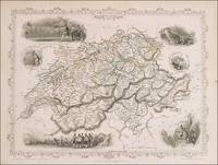
Tallis, John: Switzerland, London. [ca.1851]. From the Montgomery Martin Illustrated Atlas. Map engraved by Rapkin. Size approx 360 x 260mm. Original steel engraved map with original outline hand colouring. 6 vignette views including Bern, Chamois Hunters and William Tell shooting at the apple. Decorative border. Single page unfolded map in excellent, clean condition. Associated text page of the Montgomery Martin Atlas included.
Reviews
(Log in or Create an Account first!)
Details
- Bookseller
- Roz Hulse
 (GB)
(GB)
- Bookseller's Inventory #
- 90985
- Title
- Switzerland,
- Author
- John Tallis and Rapkin
- Illustrator
- John Tallis and Rapkin
- Book Condition
- Used
- Quantity Available
- 1
- Edition
- 1st edition
- Publisher
- From the Montgomery Martin Illustrated Atlas.
- Place of Publication
- London
- Date Published
- 1851
- Weight
- 0.00 lbs
- Bookseller catalogs
- Europe;
- Size
- Size approx 360 x 260mm
Terms of Sale
Roz Hulse
Goods remain the property of Roz Hulse until payment is cleared. All goods are returnable if you are not happy with your purchase. You must contact me within 7 days of receipt for return and refund instructions. When item is received in the same condition as sent a full refund is given. I look forward to providing you with the book or map you are seeking and giving you the best customer care.
About the Seller
Roz Hulse
Biblio member since 2005
Plymouth, Devon
About Roz Hulse
Beautiful Books Maps and Printed papers.
Glossary
Some terminology that may be used in this description includes:
- Vignette
- A decorative design or illustration placed at the beginning or end of a ...
This Book’s Categories

Is your family bible valuable?
While they may have sentimental value, bibles passed down through the family are not often worth a lot of money. Learn more...

Collecting History of the Circus in America
Step right up! Take a look at the center ring, where you will see displayed the most amazing, most colorful series of history books that the world has ever seen! Right this way, folks…
