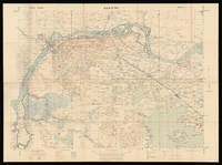
Description:
London,: Hydrographic Office of the Admiralty,, May 1st, 1843 - Corrected to 1846.. 700 by 1020mm (27.5 by 40.25 inches).. Engraved chart The British Hydrographic Office was founded in 1795 by George III, who appointed Alexander Dalrymple as the first Hydrographer to the Admiralty. The first charts were produced in 1800. Unlike the U. S. Coast Survey, the Hydrographic Office was given permission to sell charts to the public and they produced a great number of sea charts covering every corner of the globe. Most of the Admiralty charts produced by the Hydrographic Office delineated coastline as well as high and low water marks and record depth of water as established by soundings. In addition, these charts included information on shoals, reefs, and other navigational hazards that plagued mariners across the world. Thanks to the innovations of Sir Francis Beaufort, who developed the Beaufort Scale of wind strength, the British Hydrographic Office became one of the leading producers of sea charts. Sir…
Read More Search Results: Maps from Daniel Crouch Rare Books Ltd
You searched for:
- Subject: Maps from Daniel Crouch Rare Books Ltd
Results 1 - 10 of 10

Hong Kong surveyed by Capt. Sir Edward Belcher.: First British Survey of Hong Kong in H.M.S. Sulphur 1841.
by BELCHER, Captain
- Used
- Condition
- Used
- Quantity Available
- 1
- Seller
-
London, United Kingdom
- Item Price
-
NZ$42,590.00NZ$31.94 shipping to USA
Show Details
Item Price
NZ$42,590.00
NZ$31.94
shipping to USA

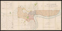
Map of Brooklyn and Vicinity.: Brooklyn as the third largest city in the United States
by DRIPPS, Matthew
- Used
- Hardcover
- Condition
- Used
- Binding
- Hardcover
- Quantity Available
- 1
- Seller
-
London, United Kingdom
- Item Price
-
NZ$2,555.40NZ$31.94 shipping to USA
Show Details
Description:
New York,: M. Dripps,, 1873.. 610 by 470mm. (24 by 18.5 inches).. Folding lithographed pocket map with contemporary hand-colour in full, tipped-in to blue cloth gilt covers, some separations and toning at old folds. Dripps' first map dedicated to Brooklyn was published in 1864. Between then and when he published the current map nearly ten years later, the third largest city in the United States, as it was then, had grown exponentially in terms of both population and geography. In 1873 Brooklyn extends north to Newtown Creek, east and southeast to Flatbush, south to 59th Street, and is bounded by the Buttermilk Canal and the East River to the West. Wards are colour-coded and numbered, with the location of XXI, XXIII, XXIV and XXV being overstamped as subdivisions of the old 21st ward, which contained Bedford. It would be another 25 years before Brooklyn extended to include all of Kings County, and was annexed as a borough of New York. The map is extremely detailed, with all major and minor road and…
Read More Item Price
NZ$2,555.40
NZ$31.94
shipping to USA
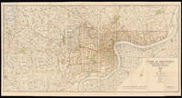
Map of Nanking: General Staff map of Nanking Compiled, drawn and printed at the War Office, 1927.
by War Office, Geographical Section, General Staff
- Used
- Condition
- Used
- Quantity Available
- 1
- Seller
-
London, United Kingdom
- Item Price
-
NZ$7,453.25NZ$31.94 shipping to USA
Show Details
Description:
War Office, Geographical Section, General Staff, 1927.. 745 by 995mm. (29.25 by 39.25 inches).. Coloured lithograph map dissected into 32 (4 by 8) sections mounted on linen. Scale 1:250,000 Nanking in 1927 was a treaty port located on the southern shores of the Yangtze River. Because the foreign interests in China were largely American and European, squadrons of foreign naval vessels were stationed along the Yangtze to protect their citizens doing business at the treaty ports. The British Royal Navy operated the China Station under Rear Admiral Sir Reginald Tyrwhitt and the United States Navy the Yangtze Patrol; both lasted for around 80 years until World War II.
Item Price
NZ$7,453.25
NZ$31.94
shipping to USA
Map of Shanghai: Map of Shanghai, 1913 Published by the North-China Daily News & Herald. Limited. by permission of the Municipal Council.
by [Anonymous]
- Used
- Signed
- Condition
- Used
- Quantity Available
- 1
- Seller
-
London, United Kingdom
- Item Price
-
NZ$42,590.00NZ$31.94 shipping to USA
Show Details
Description:
Shanghai,: North-China Daily News & Herald Limited,, 1st June 1913.. 735 by 1510mm. (29 by 59.5 inches).. A large English map of Shanghai, dissected in 40 (4 by 10) sections and mounted on linen, folding map. Oriented with north towards the upper right. Top left includes an inset of "plan shewing the rubicon road system". Signed by Engineer and Surveyor. The North-China Daily News was an English-language newspaper in Shanghai, China, the most influential foreign newspaper of its time. The paper was founded as the weekly North-China Herald ( ) and was first published on 3 August 1850. Its founder, British auctioneer Henry Shearman ( ), died in 1856.
Item Price
NZ$42,590.00
NZ$31.94
shipping to USA

A New Geological Map of England and Wales,: Rare reduction of William Smith's seminal geological map with the inland navigations; exhibiting the districts of Coal and other Sites of Mineral Tonnage by W. Smith, Engineer: 1820.
by SMITH, William
- Used
- Condition
- Used
- Quantity Available
- 1
- Seller
-
London, United Kingdom
- Item Price
-
NZ$31,942.50NZ$31.94 shipping to USA
Show Details
Description:
London,: Published by J. Cary, 86 St James's Str., March 18th, 1820.. 780 by 645mm. (30.75 by 25.5 inches).. Engraved map, fine original hand colour, dissected and mounted on linen, two small stains near the Thames Estuary, folding into original green marbled paper slipcase, publisher's label pasted to upper board, rubbed. Rare reduction of William Smith's seminal geological map; the first large scale, detailed scientific geological map of any country. The map, described on the slipcase label as "reduced from Smith's large map:' incorporates all of Smith's many revisions to his original geological map of 1815, including changes made subsequent to the latest issue (post-1817) of the wall-map. "Copies have been recorded dated 1824, 1827, and 1828, but no change in the geological lines has been observed, although the shades of colour may vary" (Eyles). The present single-sheet map was published during the same period as Smith's "Geological Survey Atlas of England:' a series of 24 slightly smaller…
Read More Item Price
NZ$31,942.50
NZ$31.94
shipping to USA
Plan of Shanghai 1928: Plan of Shanghai, 1928 Published under authority of the Municipal Council 1928.
by [Anonymous]
- Used
- Signed
- Condition
- Used
- Quantity Available
- 1
- Seller
-
London, United Kingdom
- Item Price
-
NZ$42,590.00NZ$31.94 shipping to USA
Show Details
Description:
London,: Standford's Geog.l Establishment, London,, 21st April 1928.. 880 by 1660mm. (34.75 by 65.25 inches).. A large coloured lithographed map showing the plan of Shanghai, made in 1928. Signed by Commissioner of public works, 44 (4 by 11) sheets mounted on linen. The map depicts Shanghai city in 1928, with the French Settlements and Shanghai International Settlements hand-coloured in outline in brown and pink. Two lines noted below the title: 1. The Pootung shore is taken from surveys by the Whangpoo Conservancy Board. 2. The French settlement is taken from surveys by the French Municipal Council. The famous Whangpoo (Huangpu) river in Shanghai is prominently shown from the midpoint of the bottom edge sinuating upwards to the top right corner, which divides the settlements to the left and Pootung (Pudong) to the right. Between the bank of the river and the French settlement, are the 'Chinese city' and a district labeled 'Nan Tao' (Nan Dao). The "Chinese city", is now called the "Old City", the…
Read More Item Price
NZ$42,590.00
NZ$31.94
shipping to USA
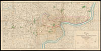
Plan of Shanghai & Environs Published Under Authority of the Municipal Council. 1933.: General Plan of Shanghai 1933
by [Anonymous]
- Used
- Hardcover
- Condition
- Used
- Binding
- Hardcover
- Quantity Available
- 1
- Seller
-
London, United Kingdom
- Item Price
-
NZ$53,237.50NZ$31.94 shipping to USA
Show Details
Description:
Shanghai,: Shanghai Municipal Council,, 27th October 1932.. 860 by 1744mm. (33.75 by 68.75 inches).. Coloured lithograph map, dissected and laid on linen, early ownership stamp of "John Pook & Co." in blank area, folding into original cloth portfolio, lettered in gilt 'General Map of Shanghai 1933' on spine. Acknowledgement is made of information obtained from the French Municipal Council, the Shanghai City Government, and the Whangpoo Conservancy Board. The map depicts Shanghai city in 1933, however, the date printed on the bottom right corner is 27th October 1932. The round shape of the Old city is still clearly visible as in the Plan of Shanghai printed in 1928, it is labelled the "Chinese City" Similarly, immediately to the north, east and west is the French Concession, and further to the north is the International Settlement. It is printed with a legend, which includes: villages and developed property; creek; motor road; path and roads; and important buildings. Compared with the Plan of…
Read More Item Price
NZ$53,237.50
NZ$31.94
shipping to USA

A Plan of the Attack by Lord Nelson of the Combined Fleet, October 21st, 1805.: Rare Broadsheet of the Battle of Trafalgar
by DODD, R[obert]
- Used
- Condition
- Used
- Quantity Available
- 1
- Seller
-
London, United Kingdom
- Item Price
-
NZ$6,388.50NZ$31.94 shipping to USA
Show Details
Description:
London,: Published by R. Dodd, marine painter, near the Admiralty,, Nov[ember], 1805.. (image) 265 by 365mm (10.5 by 14.25 inches); (sheet) 660 by 440mm (26 by 17.25 inches).. Coloured aquatint with letterpress text below, minor loss to lower right not affecting text. This rare broadside was published the month following Nelson's most famous victory. The great deciding naval battle of the Napoleonic Wars took place on 21st October 1805, off Cape Trafalgar, between 27 British ships under the command of Admiral Lord Nelson and 33 French and Spanish vessels under Admiral Villeneuve. The broadside clearly illustrates Nelson's radical battle formation of two straight lines. Although the formation would open up his vessels to enemy broadsides, it would spilt the enemies formidable line, reduce the odds, and then allow their superior gunnery and sailing skills to destroy the enemy at close range. The plan worked brilliantly, and with the French vanguard cut out of the battle by the British slicing through…
Read More Item Price
NZ$6,388.50
NZ$31.94
shipping to USA
![To The Hon[oura]ble the Court Directors of the East India Company This Improved Map of India](https://d3525k1ryd2155.cloudfront.net/h/913/468/1286468913.0.m.jpg)
To The Hon[oura]ble the Court Directors of the East India Company This Improved Map of India: The largest map of India produced before the trigonometrical survey Compiled from all the Latest & most Authentic Materials Is Respectfully Dedicated by their most Obedient & most Humble Servant A. Arrowsmith.
by ARROWSMITH, Aaron
- Used
- Condition
- Used
- Quantity Available
- 1
- Seller
-
London, United Kingdom
- Item Price
-
NZ$21,295.00NZ$31.94 shipping to USA
Show Details
Description:
London,: Published by A. Arrowsmith, Hydrographer to his Majesty, No. 10 Soho Square,, 2nd January, 1816.. 2400 by 2670mm (94.5 by 105 inches).. Large engraved map, on nine sheets, original outline hand-colour, some off-setting. Arrowsmith's monumental wall map of India on nine sheets. With the growing influence of the British in India at the end of the eighteenth century, the need for an up-to-date general map of the sub-continent grew. The first Governor-General, Warren Hastings, employed Major Rennell who, in 1779, published his famous Bengal Atlas, followed up in 1788 by his map of India. The map itself was based upon D'Anville's map of 1752, though enriched by much new material, supplied by the numerous "route surveys" carried out by the army. As these "route surveys" began to become more numerous and accurate the need for a new general map of India soon became apparent. In 1816 Aaron Arrowsmith published his Map of India in nine sheets, on a scale of sixteen miles to an inch, which was the…
Read More Item Price
NZ$21,295.00
NZ$31.94
shipping to USA

World on Mercator's Projection, Shewing the Distribution of Gold.: Unrecorded separate issue, and a possible prototype
by WYLD, James
- Used
- Hardcover
- Condition
- Used
- Binding
- Hardcover
- Quantity Available
- 1
- Seller
-
London, United Kingdom
- Item Price
-
NZ$5,323.75NZ$31.94 shipping to USA
Show Details
Description:
London,: James Wyld, Geographer to the Queen & H.R.H. Prince Albert. Model of the Earth Leicester Square,, [c1851].. 340 by 525mm. (13.5 by 20.75 inches).. Lithographed pocket map folding into publisher's green cloth wallet, with circular printed paper label on both covers, uncoloured One of five maps issued with Wyld's very rare 'Gold Fields of Australia', also 1851, this is possibly a proof or prototype copy, for issue as a pocket map, with the deposits uncoloured. No other examples of a separate issue for this map are recorded. The imprint makes reference to Wyld's famous 'Great Globe', or 'Monster Globe', constructed to coincide with the Great Exhibition, which had rejected its inclusion on account of its vast size, of more than 60 feet in diameter. It was a popular attraction at Leicester Square between 1851 and 1862. Since it was hollow, and contained a staircase and elevated platforms, the public were able to climb up inside, and feel the interior surface of the earth, complete with…
Read More Item Price
NZ$5,323.75
NZ$31.94
shipping to USA

Didn’t find what you’re looking for?
Try adding this search to your want list. Millions of books are added to our site everyday and when we find one that matches your search, we’ll send you an email. Best of all, it’s free.
Add to Want List

Are you a frequent reader or book collector?
Join the Bibliophile's Club and save 10% on every purchase, every day — up to $20 savings per order!

Social Responsibility
Did you know that since 2004, Biblio has used its profits to build 16 public libraries in rural villages of South America?
