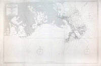
Description:
London: Published by J.F.W. Des Barres in 'The Atlantic Neptune', 1781. Etching with added hand-colour. On laid paper with 'J Bates' watermark and 'JB' countermark. A fine print from "The Atlantic Neptune" which charts the Annapolis Royal, with a coastal view of Gulliver's Hole and a descriptive text. 'The Atlantic Neptune' was the first great marine atlas, and one of the greatest achievements of eighteenth century cartography. Published in England in 1774, it contained over 250 charts and views of the North American and Canadian coasts. The charts were intensely detailed and contained both hydrographical and topographical details. The Neptune was compiled and published for the Royal Navy by Joseph F. W. Des Barres, a Swiss cartographer who joined the Royal American Regiment as a surveyor. Des Barres fought in the French and Indian wars and was enlisted to survey the Canadian coastline. While his fellow surveyor, Samuel Holland charted the New England coast, Des Barres mapped the shoreline of Nova…
Read More Search Results: Sea Charts from Donald Heald Rare Books
You searched for:
- Subject: Sea Charts from Donald Heald Rare Books
Results 1 - 20 of 24

Annapolis Royal... St. Mary's Bay
by DES BARRES, J.F.W. (1721-1824)
- Used
- Condition
- Used
- Quantity Available
- 1
- Seller
-
New York, New York, United States
- Item Price
-
NZ$5,957.70FREE shipping to USA
Show Details
Item Price
NZ$5,957.70
FREE shipping to USA
![[Buzzards Bay and Vineyard Sound.]](https://d3525k1ryd2155.cloudfront.net/h/091/093/1030093091.1.m.jpg)
[Buzzards Bay and Vineyard Sound.]
by DES BARRES, JOSEPH FREDERICK WALLET (1721-1824) and SAMUEL HOLLAND
- Used
- Condition
- Used
- Quantity Available
- 1
- Seller
-
New York, New York, United States
- Item Price
-
NZ$48,512.70FREE shipping to USA
Show Details
Description:
London: J. F. W. Des Barres for The Atlantic Neptune, 1776. Large engraved chart from Des Barres' Atlantic Neptune on two sheets of laid paper, joined, each bearing "J Bates" watermark. 43x31 inches sheet size, nice margins; contemporary hand-color in outline; slightest offsetting, a superior copy. State 4 of 7. Fine chart depicting the waters between New Bedford and Martha's Vineyard. Buzzards Bay and the Vineyard Sound including the Elizabeth Islands and the western half of Martha's Vineyard. Showing much more on-shore information than is typical for a Des Barres chart, there are details of property boundaries, structures, even a road from Menemshaw Pond to Tisbury. Native names throughout remain largely unchanged today. Joseph Des Barres was born in Switzerland in 1721 and educated in Basel before emigrating to England and entering the Royal Military College where he learned engineering and the art of surveying. In 1756, Des Barres was commissioned a Lieutenant in the Royal American Regiment and…
Read More Item Price
NZ$48,512.70
FREE shipping to USA

A Chart of the Harbour of Louisbourg in the Island of Cape Breton
by DES BARRES, J.F.W. (1721-1824)
- Used
- Condition
- Used
- Quantity Available
- 1
- Seller
-
New York, New York, United States
- Item Price
-
NZ$7,659.90FREE shipping to USA
Show Details
Description:
London, 1781. Engraved chart, the town and border hand-coloured as issued. Minor repaired edge tears. Sheet Size: 22 5/8 x 32 1/2 inches. An important 18th century chart of Louisbourg harbour. Des Barres, of Swiss-Huguenot extraction, studied under the great mathematician Daniel Bernoulli at the University of Basel, before continuing on to the Royal Military College at Woolwich. Upon the outbreak of hostilities with France in 1756, he joined the British Royal American Regiment as a military engineer. He came to the attention of General James Wolfe, who appointed him to join his personal detail. During this period he also worked with the future legendary explorer James Cook on a monumental chart of the St. Lawrence River. From 1762, Des Barres was enlisted to survey the coastlines of Nova Scotia, Newfoundland, and the Gulf of St. Lawrence, while his colleague, Samuel Holland charted the New England coast. He also managed to gain access to some surveys of the American South, Cuba and Jamaica. In 1774,…
Read More Item Price
NZ$7,659.90
FREE shipping to USA
![Chart of Port Shediack [&] Cocagne (New Brunswick)](https://d3525k1ryd2155.cloudfront.net/h/580/933/1237933580.1.m.jpg)
Chart of Port Shediack [&] Cocagne (New Brunswick)
by DES BARRES, J.F.W. (1721-1824)
- Used
- Condition
- Used
- Quantity Available
- 1
- Seller
-
New York, New York, United States
- Item Price
-
NZ$4,255.50FREE shipping to USA
Show Details
Description:
London: J. F. W. Des Barres for 'The Atlantic Neptune', 1781. Etched with aquatint and stippling. Some outline color. Platemark: 29 1/4 x 21 3/8 inches; sheet: 32 3/4 x 24 3/4 inches. Laid paper watermarked "J. Bates" with counter mark "J.B." A meticulous survey of a portion of the eastern coast of New Brunswick on the Northumberland Straits with soundings and topographical detailing. This chart, which appeared in Volume II of The Atlantic Neptune, was part of the surveying work conducted by Des Barres himself in the late 1760s and early 1770s. The first state was issued in 1776; this enhanced second state appeared in 1779. Des Barres, of Swiss-Huguenot extraction, studied under the great mathematician Daniel Bernoulli at the University of Basel, before continuing on to the Royal Military College at Woolwich. Upon the outbreak of hostilities with France in 1756, he joined the British Royal American Regiment as a military engineer. He came to the attention of General James Wolfe, who appointed him to…
Read More Item Price
NZ$4,255.50
FREE shipping to USA

More Photos
Chart of the Coast of America from C. Eliz to Mouse Harbor from the Latest Surveys
by CLARK, Matthew (1714-1798)
- Used
- Condition
- Used
- Quantity Available
- 1
- Seller
-
New York, New York, United States
- Item Price
-
NZ$85,110.00FREE shipping to USA
Show Details
Description:
Boston: Matthew Clark, 1790. Engraved map on two folding sheets joined, irregularly shaped as issued, sheet size approximately 23 3/4 x 33 1/2 inches. Expert restoration at the folds. Chart numbers 5 and 6. Printed cartographic Americana of the greatest rarity, a map of the Maine and Cape Cod coasts from the first American-made atlas: "The first totally American production of its kind." [Garvan] Following the American Revolution, as the United States began to form a political identity within their newly-defined boundaries, American cartographers began to wrest control from their former colonial rulers on how those boundaries would be depicted. In 1784, Abel Buell, a Connecticut silversmith and engraver, produced the first map of the United States published in America; in 1789, Christopher Colles, a New York engineer, would begin publishing strip maps of American roads; and in 1790, Matthew Clark, a Boston merchant and auctioneer, published the country's very first atlas. Clark's business largely…
Read More Item Price
NZ$85,110.00
FREE shipping to USA

More Photos
A Chart of the Coast of Guinea from Cape de Verde to Cape Bona Esperança
by THORNTON, John (1641-1708) & Samuel (fl.1703-39)
- Used
- Condition
- Used
- Quantity Available
- 1
- Seller
-
New York, New York, United States
- Item Price
-
NZ$1,106.43FREE shipping to USA
Show Details
Description:
London: William Mount & Thomas Page, 1734. Copper-engraved sea chart, in excellent condition. A very elegant sea chart of all of the west coast of Africa and one of the most important charts of the celebrated Third Book of 'The English Pilot' This very fine sea chart embraces the coast of Africa from Senegal all the way down to Cape Agulhas, past the Cape of Good Hope. The features of the coast are named in great detail, and the seas are elegantly traversed by loxodromes. The map is oriented with the east towards the top of the map, and a very beautiful cartouche surrounded by mermen and seashells adorns the upper left corner. In 1671, the London cartographer John Seller (fl.1664-97) commenced work on The English Pilot, a work that intended to challenge Dutch hegemony in the sea atlas market. Intended to be published in four books covering different regions of the globe, Seller published an uncompleted book on 'Oriental navigation' in 1675. Unable to continue this Herculean endeavour, Seller sold…
Read More Item Price
NZ$1,106.43
FREE shipping to USA
![[Chart of the Coast of Georgia]](https://d3525k1ryd2155.cloudfront.net/h/830/835/565835830.1.m.jpg)
[Chart of the Coast of Georgia]
by DES BARRES, J.F.W. (1721-1824)
- Used
- Condition
- Used
- Quantity Available
- 1
- Seller
-
New York, New York, United States
- Item Price
-
NZ$38,299.50FREE shipping to USA
Show Details
Description:
[London, 1780. Aquatint and line engraving, period hand colouring. Very rare first state of Des Barres's chart of the coast of Georgia. This fine chart is from "The Atlantic Neptune," one of the finest large scale sea atlases of the United States and Canadian Atlantic coastline ever produced. The maps in the atlas were produce over a seven-year period (1775-82), and are well known for their accurate portrayal of various sounds, bays, bars, harbors as well as navigational hazards. This atlas was used extensively by the Royal Navy during the American Revolution. This is a detailed chart of the Georgia and upper Florida coastlines, covering an area between the mouth of the River May to John's Island. The towns of Savannah, Beaufort, Hardwick and Sunbury are shown and the coastal Parishes in Georgia are names. To the west is noted "Indian Boundary Line." This very rare first state is larger than the subsequent two states, without any detail added to the South Carolina coast and without the inset in the…
Read More Item Price
NZ$38,299.50
FREE shipping to USA
![Chart of the Coast of America from Cape Hateras [sic] to Cape Roman from the actual surveys of...](https://d3525k1ryd2155.cloudfront.net/h/209/934/290934209.0.m.jpg)
More Photos
Chart of the Coast of America from Cape Hateras [sic] to Cape Roman from the actual surveys of Dl. Dunbibin Esq
by [NORMAN, John]
- Used
- Condition
- Used
- Quantity Available
- 1
- Seller
-
New York, New York, United States
- Item Price
-
NZ$72,343.50FREE shipping to USA
Show Details
Description:
[Boston: John Norman, 1794. Copper-engraved sea chart, on two joined sheets. Overall sheet size: 21 1/4 x 33 inches. An early issue of the earliest American chart of the North Carolina coast. Wheat and Brun, and others, speculate that the original version of this map was separately published in 1761, citing an advertisement in the September 14, 1761 Boston Gazette: "The Navigation on the Coast of North and South Carolina being very dangerous on account of the many Bars, Shoals, Sandbanks, Rocks, etc. The late Daniel Dunbibin, Esq. of North Carolina, has, at very great Expence and Labour, draughted the Sea Coast of both the Provinces in a large whole Sheet Chart of 33 inches by 23; together with all the Rivers, Bays, Inlets, Islands, Brooks, Bars, Shoals, Rocks, Soundings, Currents, &c. with necessary Directions to render the Navigation both easy and safe, and are much esteemed by the most expert Pilots..." No copy of this 1761 map is known to exist. It is believed, however, that John Norman re-used…
Read More Item Price
NZ$72,343.50
FREE shipping to USA
![A Chart of Delawar[e] Bay with Soundings and Nautical Observations taken by Capt. Sir Andrew...](https://d3525k1ryd2155.cloudfront.net/h/420/834/170834420.0.m.jpg)
More Photos
A Chart of Delawar[e] Bay with Soundings and Nautical Observations taken by Capt. Sir Andrew Snape Hammond of the Navy and others Composed and Published for The Use of Pilotage...
by DES BARRES, Joseph F. Wallet (1721-1824)
- Used
- Condition
- Used
- Quantity Available
- 1
- Seller
-
New York, New York, United States
- Item Price
-
NZ$17,022.00FREE shipping to USA
Show Details
Description:
London: Published by J. F. W. Des Barres in 'The Atlantic Neptune', 1779. Black and white copper engraving. Large repaired tear (12") from bottom edge, parallel to centerfold. 4" repaired split from bottom in centerfold. Thin, uneven margins. Plate size: 30 1/4 x 22 1/8 inches. This is a fantastic sea chart of the Delaware coast from the 'The Atlantic Neptune' which is universally recognized as one of the most magnificent atlases ever made. This superb sea chart, constructed for the use of the British Navy, shows the major part of the Delaware coast, from Rehobeth to Bombay Hook, as well as the opposing south New Jersey shore. 'The Atlantic Neptune' was the first great marine atlas, and one of the great achievements of eighteenth century cartography. When publication in England began in 1774, it contained over 250 charts and views of the North American and Canadian coasts. The charts were intensely detailed and contained both hydrographical and topographical details. The Neptune was compiled and…
Read More Item Price
NZ$17,022.00
FREE shipping to USA
More Photos
Delta de Mississippi
by SPANISH ADMIRALTY
- Used
- Condition
- Used
- Quantity Available
- 1
- Seller
-
New York, New York, United States
- Item Price
-
NZ$3,149.07FREE shipping to USA
Show Details
Description:
Madrid: Published by the Spanish Admiralty, 1880. Engraving. Printed on wove paper. In excellent condition. Image size: 24 x 37 1/4 inches. A wonderful sea chart of the Mississippi Delta produced by the Spanish Admiralty at the close of the nineteenth century. This is an impressive sea chart of the Mississippi Delta produced by the Spanish Admiralty in 1880. The coast line is clearly mapped out with little detailing except for the soundings around the Delta. There are two compasses and a number of lighthouses identified along the shoreline. The chart uses the surveys conducted by the U. S. Coast Survey, which were carried out between 1853 and 1877. It is a wonderful chart of this important area and superb collector's piece for anyone interested in early maps of the Americas.
Item Price
NZ$3,149.07
FREE shipping to USA
![[Denmark] Carte de Detroit du Sond Contenant les Costes de L'Isle de Zélande Comprises ente...](https://d3525k1ryd2155.cloudfront.net/h/378/081/66081378.0.m.jpg)
More Photos
[Denmark] Carte de Detroit du Sond Contenant les Costes de L'Isle de Zélande Comprises ente Nicopen et L'Isle de Meun, et Celles du Schonen Depuis la Pointe de Kol, jusqu'a Valsterbon. Levée et Gravée Par Ordre du Roy
by MORTIER, Pierre (1661-1711)
- Used
- Condition
- Used
- Quantity Available
- 1
- Seller
-
New York, New York, United States
- Item Price
-
NZ$2,127.75FREE shipping to USA
Show Details
Description:
Paris [Amsterdam: Pierre Mortier], 1693. Engraved with full, period colour and gold embellishment. A magnificent 17th century sea chart of Copenhagen and surrounding regions. This large scale, beautifully coloured coastal chart of the coast of Sjaelland (Zéland), Denmark and the south-western tip of Sweden comes from Le Neptune François, a lavish collection of charts produced collaboratively by Hubert Jaillot and Pierre Mortier. As Koeman discovered in his research on this work (see P. Mortier, Atlantes Neerlandici, Maritime Atlases, p. 423-4), Mortier re-engraved the plates after the original French prototype Neptune François by Charles Pène and others in a richly coloured version and added to the titles the words "Levée et Gravée par Ordre du Roy à Paris 1693. though they were in fact engraved, coloured and published in Amsterdam by Mortier. The Netherlands and France were engaged in the War of the Grand Alliance at this time. Pierre Mortier's grandparents were French refugees, who left…
Read More Item Price
NZ$2,127.75
FREE shipping to USA
![Egmont Harbour [modern Jeddore Harbour, Nova Scotia]](https://d3525k1ryd2155.cloudfront.net/h/114/954/733954114.1.m.jpg)
Egmont Harbour [modern Jeddore Harbour, Nova Scotia]
by DES BARRES, J.F.W. (1721-1824)
- Used
- Condition
- Used
- Quantity Available
- 1
- Seller
-
New York, New York, United States
- Item Price
-
NZ$4,255.50FREE shipping to USA
Show Details
Description:
London: Published by J.F.W. Des Barres in 'The Atlantic Neptune', 1779. Sea chart, etched with roulette-work, with original colour, with aquatint view. Printed on laid paper with 'J Bates' watermark and 'JB' countermark. A very fine sea chart and view of Egmont, now called Jeddore Harbour, from 'The Atlantic Neptune,' the first British sea atlas of her North American colonies This is a finely presented and highly detailed chart of what is now known as Jeddore Harbour, near Halifax. The bay, seven miles long and three miles wide, is captured in a cartographic composition of great topographical and hydrographical detail, and is further embellished by a roundel containing a mariner's view of the area. This chart is the fifth and final state produced, and is identical to the Henry Stevens Collection, variant 49G, in the National Maritime Museum, Greenwich. Des Barres studied under the great mathematician Daniel Bernoulli at the University of Basel, before continuing on to the Royal Military College at…
Read More Item Price
NZ$4,255.50
FREE shipping to USA
![[English Channel] Canalis inter Angliæ et Galliæ Littora. Pasecaert van 't Canaal tusschen...](https://d3525k1ryd2155.cloudfront.net/h/196/083/66083196.0.m.jpg)
More Photos
[English Channel] Canalis inter Angliæ et Galliæ Littora. Pasecaert van 't Canaal tusschen Engeland en Vranckryck
by RENARD, Louis (1678-1746)
- Used
- Condition
- Used
- Quantity Available
- 1
- Seller
-
New York, New York, United States
- Item Price
-
NZ$4,085.28FREE shipping to USA
Show Details
Description:
[Amsterdam: Renard, 1739. Copper-engraved sea chart, with full orginal colour, in very good condition. A highly decorative sea chart of the English Channel, by the master-engraver Renard. The marine atlases of 17th and 18th century Holland were best sellers. The nation that led the world in overseas commerce also led in the arts of engraving and cartography. Plus, there was a large audience of mariners and mariners' parents, who needed to study the obscure straits and recently discovered island groups their sons were seeing. Louis Renard (1678-1746) was from a Huguenot family. He moved from France to the Netherlands and became a book dealer and publisher in Amsterdam in 1703. Louis Renard first published Atlas de la Navigation, et du Commerce qui se fait dans toutes les parties du monde in 1715. It was re-issued unchanged by the Ottens in 1739. The charts were printed from plates made by Frederick de Wit in 1675, Orbis Maritimus ofte Zee Atlas. These were corrected by Renard, using, primarily, van…
Read More Item Price
NZ$4,085.28
FREE shipping to USA

More Photos
A Large Draught of the North Part of China Shewing the Passages and the Chanells into the Harbour of Chusan
by THORNTON, John (1641-1708) & Samuel (fl.1703-39)
- Used
- Condition
- Used
- Quantity Available
- 1
- Seller
-
New York, New York, United States
- Item Price
-
NZ$2,042.64FREE shipping to USA
Show Details
Description:
London: William Mount & Thomas Page, 1734. Copper-engraved sea chart, in excellent condition, apart from an expertly repaired centre fold, and mild creases where the map folded. A very fine sea chart of China's Zhejiang Province, from the celebrated Third Book of 'The English Pilot.' This elegant and large sea chart captures China's modern day Zhejiang province. Located on the East China sea, just below the Yangtze Delta, this region was of major interest to European traders during the eighteenth-century. It features the major port of Zhousan (Chusan), and was the location of the entrance of the Grand Canal of China. The canal, construction of which began in the 5th-century B.C., was then the oldest and longest man-made waterway in the world, which allowed barges to travel hundreds to Beijing. In 1671, the London cartographer John Seller (fl.1664-97) commenced work on The English Pilot, a work that intended to challenge Dutch hegemony in the sea atlas market. Intended to be published in four books…
Read More Item Price
NZ$2,042.64
FREE shipping to USA

More Photos
A Large Draught of the Coast of Arabia from Maculla to Dofar
by THORNTON, John (1641-1708) & Samuel (fl.1703-39)
- Used
- Condition
- Used
- Quantity Available
- 1
- Seller
-
New York, New York, United States
- Item Price
-
NZ$1,276.65FREE shipping to USA
Show Details
Description:
London: William Mount & Thomas Page, 1734. Copper-engraved sea chart by Sutton Nichols, in excellent condition apart from a small expert repair to the lower right and left corners. A very fine sea chart of the coast of Yemen and Oman from the celebrated Third Book of 'The English Pilot' This very attractive sea chart depicts the coast of the Arabian Peninsula from Al Makullah in Yemen to Dhofar in Oman. The coastal view is bisected into two images, separated by a border formed by the elegant tendrils of a vine. The upper view depicts the southern, while the lower portrays the northern aspect of the coast. Prominent features of the desert coastline are depicted, while compass roses, from which radiate rhumb lines, decorate the seas. In 1671, the London cartographer John Seller (fl.1664-97) commenced work on The English Pilot, a work that intended to challenge Dutch hegemony in the sea atlas market. Intended to be published in four books covering different regions of the globe, Seller published an…
Read More Item Price
NZ$1,276.65
FREE shipping to USA

More Photos
A Large Draught of the South Part of Borneo
by THORNTON, John (1641-1708) & Samuel (fl.1703-39)
- Used
- Condition
- Used
- Quantity Available
- 1
- Seller
-
New York, New York, United States
- Item Price
-
NZ$765.99FREE shipping to USA
Show Details
Description:
London: William Mount & Thomas Page, 1734. Copper-engraved sea chart, in excellent condition apart from a skillfully repaired marginal split at the base of the centerfold and marginal soiling. A very attractive sea chart of southern Borneo, from the celebrated Third Book of the 'English Pilot' This very attractive sea chart depicts Kalimantan, now the Indonesian section of Borneo and the adjacent part of the Java Sea. While the delineation of the coast is geographically well assured, the interior of the island is shown to be virtually unknown. Inhabited by fierce indigenous tribes and exotic animals, agents of the Dutch East Indian Company, who then nominally controlled the coasts, were afraid to venture into the interior. Indeed, parts of Borneo have not even been fully explored to this day. The Java Sea is elegantly adorned with rhumb lines that radiate from a compass rose and from centerpoints placed on an invisible circle. A handsome title cartouche embellishes the lower left corner of the…
Read More Item Price
NZ$765.99
FREE shipping to USA
![[Miramichi Bay]](https://d3525k1ryd2155.cloudfront.net/h/570/933/1237933570.1.m.jpg)
[Miramichi Bay]
by DES BARRES, Joseph F. Wallet (1721-1824)
- Used
- Condition
- Used
- Quantity Available
- 1
- Seller
-
New York, New York, United States
- Item Price
-
NZ$3,404.40FREE shipping to USA
Show Details
Description:
[London: J. F. W. Des Barres, 1781. Engraved with aquatint, on single double-page sheet watermarked "J. Bates." Excellent condition with minor repairs along centerfold. Detailed depiction of the mouth of the Miramachi River in New Brunswick and Miramachi Bay in the Gulf of St. Larwence. Des Barres, of Swiss-Huguenot extraction, studied under the great mathematician Daniel Bernoulli at the University of Basel, before continuing on to the Royal Military College at Woolwich. Upon the outbreak of hostilities with France in 1756, he joined the British Royal American Regiment as a military engineer. He came to the attention of General James Wolfe, who appointed him to join his personal detail. During this period he also worked with the future legendary explorer James Cook on a monumental chart of the St. Lawrence River. From 1762, Des Barres was enlisted to survey the coastlines of Nova Scotia, Newfoundland, and the Gulf of St. Lawrence, while his colleague, Samuel Holland charted the New England coast.…
Read More Item Price
NZ$3,404.40
FREE shipping to USA
![North East Coast of Nova Scotia / Northumberland Streights [sic] (One sheet)](https://d3525k1ryd2155.cloudfront.net/h/569/933/1237933569.1.m.jpg)
North East Coast of Nova Scotia / Northumberland Streights [sic] (One sheet)
by DES BARRES, J.F.W. (1721-1824)
- Used
- Condition
- Used
- Quantity Available
- 1
- Seller
-
New York, New York, United States
- Item Price
-
NZ$4,255.50FREE shipping to USA
Show Details
Description:
[London: British Admiralty for 'The Atlantic Neptune'], 1779. Etching with roulette work, original outline color on laid paper watermarked "JBates" and countermarked "JB" This excellent example of Des Barres' craftsmanship details a portion of the strait between New Brunswick and what is now Prince Edward Island (then St. John's Island). It includes on the New Brunswick side: Shediac, Cocagne and Boutouche. The chart includes soundings throughout the Straits and Baie Verte. This is one of the many regions Des Barres himself surveyed during the 1760s. Des Barres, of Swiss-Huguenot extraction, studied under the great mathematician Daniel Bernoulli at the University of Basel, before continuing on to the Royal Military College at Woolwich. Upon the outbreak of hostilities with France in 1756, he joined the British Royal American Regiment as a military engineer. He came to the attention of General James Wolfe, who appointed him to join his personal detail. During this period he also worked with the future…
Read More Item Price
NZ$4,255.50
FREE shipping to USA

More Photos
Pas-kaart van de Golff van Mexico
by KEULEN, Johannes van (1654-1715) and Claes Janszoon VOOGHT (d. 1696)
- Used
- Condition
- Used
- Quantity Available
- 1
- Seller
-
New York, New York, United States
- Item Price
-
NZ$9,787.65FREE shipping to USA
Show Details
Description:
Amsterdam: Johannes Van Keulen, 1687. Copper-engraved map, period hand-colouring. Inset of the waters near Vera Cruz. (Expert restoration at sheet edges). Van Keulen's scarce 17th century chart of the western Gulf of Mexico, oriented with west toward the top of the page. Van Keulen's rare chart of the western portion of the Gulf of Mexico "covers the coastline from the panhandle of present day Florida around to the Yucatan peninsula. The main feature of this map is its originality of form. It is the first sea chart of the western portion of the Gulf of Mexico detailing the coastal waters of present-day Florida, Alabama, Mississippi, Louisiana and Texas. The geography is largely derived from the exceedingly rare Hessel Gerritz chart of c. 1631" (Burden). As expected, most of the toponyms are Spanish and the mouth of the Mississippi is labelled Baja de Spirito Sancto. Oriented to the west, "it represented the most sophisticated rendering of the coast then available" (Martin & Martin). The Texas…
Read More Item Price
NZ$9,787.65
FREE shipping to USA

More Photos
Pemaquid Pt. to Fletchers Neck
by BRITISH HYDROGRAPHIC OFFICE
- Used
- Condition
- Used
- Quantity Available
- 1
- Seller
-
New York, New York, United States
- Item Price
-
NZ$4,255.50FREE shipping to USA
Show Details
Description:
London: Published by the Admiralty, 1866. Engraving. Printed on wove paper. In excellent condition. Two joined sheets. Image size: 37 1/2 x 39 1/2 inches. An excellent admiralty chart of Casco Bay, Maine from Pemaquid Point to Fletcher's Neck, produced by the British Hydrographic Office. The British Hydrographic Office was founded in 1795 by George III, who appointed Alexander Dalrymple as the first Hydrographer to the Admiralty. He immediately set to work but it was not until 1800 that the first Admiralty chart was published of the waters around Quiberon Bay in Brittany. Unlike the U. S. Coast Survey the Hydrographic Office was given permission to sell charts to the public and they produced a great number of sea charts covering every corner of the globe. Most of the Admiralty charts produced by the Hydrographic Office delineated coastline as well as high and low water marks and recorded depth of water as established by soundings. In addition these charts included information on shoals, reefs, and…
Read More Item Price
NZ$4,255.50
FREE shipping to USA

Didn’t find what you’re looking for?
Try adding this search to your want list. Millions of books are added to our site everyday and when we find one that matches your search, we’ll send you an email. Best of all, it’s free.
Add to Want List

Are you a frequent reader or book collector?
Join the Bibliophile's Club and save 10% on every purchase, every day — up to $20 savings per order!

Social Responsibility
Did you know that since 2004, Biblio has used its profits to build 16 public libraries in rural villages of South America?
