Description:
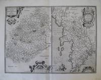
Europe: Antverpiæ"/Antwerp. "ex Officiana Plantiana" . Plantijn Christoffel. 1595. Copper engraved map of Anjou (after Licinio Guyeto/ Lezin Guyet 1515-80 ) from Ortelius' "Theatrum Orbis Terrarum" 1595 edition; black & white. Latin text to verso. Good dark impression: wormhole to lower centrefold within "MERIDIES"; tear [18mm]at lower centrefold caused by guard, repaired. Abraham Ortelius,[ 1527-1598] Flemish Cartographer . produced the first modern Atlas "Theatrum Orbis Terrarum" in 1570. printed by Aegidus Coppen Diest. There were numerous editions thereafter with texts in various languages; the printing of such was taken over by Chrstoffel Plantijn in 1579 . Ortelius himself drew all the maps in manuscript before passing them to the printers. there is conjecture that he may have engraved some of the plates as well The 1595 Latin text edition is the most complete produced during his lifetime, containing all the maps of the 1593 edition plus those of the the"Additamentum" and…
Read More Search Results: Europe from Mary Louise Bryan/Paralos Gallery
You searched for:
- Subject: Europe from Mary Louise Bryan/Paralos Gallery
Results 1 - 20 of 35

Andegavenium Ducatus. " Anjou, Andegavensium Ditionis Vera et Integra Descriptio
by Ortelius, Abraham
- Used
- Condition
- Used
- Quantity Available
- 1
- Seller
-
Nafplion, Greece
- Item Price
-
NZ$364.76NZ$18.24 shipping to USA
Show Details
Item Price
NZ$364.76
NZ$18.24
shipping to USA

Asores Insula; Tercera; Pico; Fayala. "Açores Insulae
by Ortelius, Abraham
- Used
- Condition
- Used
- Quantity Available
- 1
- Seller
-
Nafplion, Greece
- Item Price
-
NZ$911.90NZ$18.24 shipping to USA
Show Details
Description:
Europe: Antverpiæ"/Antwerp. "ex Officiana Plantiana" . Plantijn Christoffel. 1595. Copper engraved map of the islands of the Azores, Portugal from Ortelius' "Theatrum Orbis Terrarum" 1595 edition; black & white. Latin text to verso. Decorative map of the most Western point of Europe, the Azores belong to Portugal and as such Europe extends very far west into the Atlantic. 3 cartouches; ships & monsters to the sea. Good dark impression; tiny wormhole to lower centre fold within "MERIDES". Abraham Ortelius,[ 1527-1598] Flemish Cartographer . produced the first modern Atlas "Theatrum Orbis Terrarum" in 1570. printed by Aegidus Coppen Diest. There were numerous editions thereafter with texts in various languages; the printing of such was taken over by Chrstoffel Plantijn in 1579 . Ortelius himself drew all the maps in manuscript before passing them to the printers. there is conjecture that he may have engraved some of the plates as well The 1595 Latin text edition is the most complete produced…
Read More Item Price
NZ$911.90
NZ$18.24
shipping to USA

Biturigum Regio; Limania. "Regionis Biturigum Exactiss Descriptio.." & "Limaniae topographia
by Ortelius, Abraham
- Used
- Condition
- Used
- Quantity Available
- 1
- Seller
-
Nafplion, Greece
- Item Price
-
NZ$273.57NZ$18.24 shipping to USA
Show Details
Description:
Europe: Antverpiæ"/Antwerp. "ex Officiana Plantiana" . Plantijn Christoffel. 1595. 2 copper engraved maps on 1 plate of Berry (after Ioannem Calamaeum), & Limmania region of the Auvergne (after Gabriele Symeoneo) from Ortelius' "Theatrum Orbis Terrarum" 1595 edition; black & white. Latin text to verso. Good dark impression. Abraham Ortelius,[ 1527-1598] Flemish Cartographer . produced the first modern Atlas "Theatrum Orbis Terrarum" in 1570. printed by Aegidus Coppen Diest. There were numerous editions thereafter with texts in various languages; the printing of such was taken over by Chrstoffel Plantijn in 1579 . Ortelius himself drew all the maps in manuscript before passing them to the printers. there is conjecture that he may have engraved some of the plates as well The 1595 Latin text edition is the most complete produced during his lifetime, containing all the maps of the 1593 edition plus those of the the"Additamentum" and the"Pareragon" or Ancient geography. The " Additamenta" were…
Read More Item Price
NZ$273.57
NZ$18.24
shipping to USA
Brittania et Normandia; Cenomani. "Britaniae et Normandiae Typus 1594" & "Cenomanorum Galliæ regionis typus / La Mans
by Ortelius, Abraham
- Used
- Condition
- Used
- Quantity Available
- 1
- Seller
-
Nafplion, Greece
- Item Price
-
NZ$547.14NZ$18.24 shipping to USA
Show Details
Description:
Europe: Antverpiæ"/Antwerp. "ex Officiana Plantiana" . Plantijn Christoffel. 1595. 2 copper engraved maps on 1 plate of Brittany & Normandy, with the Le Mans area (after Mattheo Ogerio) from Ortelius' "Theatrum Orbis Terrarum" 1595 edition; black & white. Latin text to verso. Good dark impression. Abraham Ortelius,[ 1527-1598] Flemish Cartographer . produced the first modern Atlas "Theatrum Orbis Terrarum" in 1570. printed by Aegidus Coppen Diest. There were numerous editions thereafter with texts in various languages; the printing of such was taken over by Chrstoffel Plantijn in 1579 . Ortelius himself drew all the maps in manuscript before passing them to the printers. there is conjecture that he may have engraved some of the plates as well The 1595 Latin text edition is the most complete produced during his lifetime, containing all the maps of the 1593 edition plus those of the the"Additamentum" and the"Pareragon" or Ancient geography. The " Additamenta" were supplements to the original…
Read More Item Price
NZ$547.14
NZ$18.24
shipping to USA

Buchavia vel Buchonia; Waldeccia Comitatus. "Buhaviae sive Fuldensis Ditionis Typus..." & "Waldeccensis Comitatus Descriptio Accuratissima
by Ortelius, Abraham
- Used
- Condition
- Used
- Quantity Available
- 1
- Seller
-
Nafplion, Greece
- Item Price
-
NZ$273.57NZ$18.24 shipping to USA
Show Details
Description:
Europe: Antverpiæ"/Antwerp. "ex Officiana Plantiana" . Plantijn Christoffel. 1595. 2 copper engraved maps on 1 plate of Buchavia or Fulda [after Wolfgang Regerwyl] & the Duchy of Waldeck,Germany from Ortelius' "Theatrum Orbis Terrarum" 1595 edition; black & white. Latin text to verso. Good dark impression. Abraham Ortelius,[ 1527-1598] Flemish Cartographer . produced the first modern Atlas "Theatrum Orbis Terrarum" in 1570. printed by Aegidus Coppen Diest. There were numerous editions thereafter with texts in various languages; the printing of such was taken over by Chrstoffel Plantijn in 1579 . Ortelius himself drew all the maps in manuscript before passing them to the printers. there is conjecture that he may have engraved some of the plates as well The 1595 Latin text edition is the most complete produced during his lifetime, containing all the maps of the 1593 edition plus those of the the"Additamentum" and the"Pareragon" or Ancient geography. The " Additamenta" were supplements to…
Read More Item Price
NZ$273.57
NZ$18.24
shipping to USA

Burgundiæ Ducatus. "Burgundiae Inferioris, Quæ Ducatus Nomine Censetur Des. 1584
by Ortelius, Abraham
- Used
- Condition
- Used
- Quantity Available
- 1
- Seller
-
Nafplion, Greece
- Item Price
-
NZ$364.76NZ$18.24 shipping to USA
Show Details
Description:
Europe: Antverpiæ"/Antwerp. "ex Officiana Plantiana" . Plantijn Christoffel. 1595. Copper engraved map of Lower Burgundy, the Duchy from Ortelius' "Theatrum Orbis Terrarum" 1595 edition; black & white. Latin text to verso. Good dark impression; some dampstaining to lower blank margin. Abraham Ortelius,[ 1527-1598] Flemish Cartographer . produced the first modern Atlas "Theatrum Orbis Terrarum" in 1570. printed by Aegidus Coppen Diest. There were numerous editions thereafter with texts in various languages; the printing of such was taken over by Chrstoffel Plantijn in 1579 . Ortelius himself drew all the maps in manuscript before passing them to the printers. there is conjecture that he may have engraved some of the plates as well The 1595 Latin text edition is the most complete produced during his lifetime, containing all the maps of the 1593 edition plus those of the the"Additamentum" and the"Pareragon" or Ancient geography. The " Additamenta" were supplements to the original Atlas; at…
Read More Item Price
NZ$364.76
NZ$18.24
shipping to USA

Burgundia Comitatus. "Burgundiae Comitatus Recentiss. Descriptio
by Ortelius, Abraham
- Used
- Condition
- Used
- Quantity Available
- 1
- Seller
-
Nafplion, Greece
- Item Price
-
NZ$547.14NZ$18.24 shipping to USA
Show Details
Description:
Europe: Antverpiæ"/Antwerp. "ex Officiana Plantiana" . Plantijn Christoffel. 1595. Copper engraved map of Franche- Comte/ Burgundy from Ortelius' "Theatrum Orbis Terrarum" 1595 edition; black & white. Latin text to verso. Good dark impression; some light dampstaining to lower blank margin. Abraham Ortelius,[ 1527-1598] Flemish Cartographer . produced the first modern Atlas "Theatrum Orbis Terrarum" in 1570. printed by Aegidus Coppen Diest. There were numerous editions thereafter with texts in various languages; the printing of such was taken over by Chrstoffel Plantijn in 1579 . Ortelius himself drew all the maps in manuscript before passing them to the printers. there is conjecture that he may have engraved some of the plates as well The 1595 Latin text edition is the most complete produced during his lifetime, containing all the maps of the 1593 edition plus those of the the"Additamentum" and the"Pareragon" or Ancient geography. The " Additamenta" were supplements to the original Atlas;…
Read More Item Price
NZ$547.14
NZ$18.24
shipping to USA

Caletetes & Bononieinsis; Veromandui. "Caletensium et bononiensium Ditionis Accurata Delineatio.." & "Veromanduorum Eorumque Confinitum Exactissima Descriptio
by Ortelius, Abraham
- Used
- Condition
- Used
- Quantity Available
- 1
- Seller
-
Nafplion, Greece
- Item Price
-
NZ$273.57NZ$18.24 shipping to USA
Show Details
Description:
Europe: Antverpiæ"/Antwerp. "ex Officiana Plantiana" . Plantijn Christoffel. 1595. 2 copper engraved maps on 1 plate of Calais & Boulogne (after Nicolao Nicolai delphinatus, Paris 1558) & Vermandois (after Johannes Surhon) from Ortelius' "Theatrum Orbis Terrarum" 1595 edition; black & white. Latin text to verso. Good dark impression: wormhole to lower centrefold between the maps; show through of title from verso. Abraham Ortelius,[ 1527-1598] Flemish Cartographer . produced the first modern Atlas "Theatrum Orbis Terrarum" in 1570. printed by Aegidus Coppen Diest. There were numerous editions thereafter with texts in various languages; the printing of such was taken over by Chrstoffel Plantijn in 1579 . Ortelius himself drew all the maps in manuscript before passing them to the printers. there is conjecture that he may have engraved some of the plates as well The 1595 Latin text edition is the most complete produced during his lifetime, containing all the maps of the 1593 edition plus…
Read More Item Price
NZ$273.57
NZ$18.24
shipping to USA

Creta; Sardinia; Corsica; Insula Maris Ionii. "Creta Iouis Magni, medio iacet insula ponto
by Ortelius, Abraham
- Used
- Condition
- Used
- Quantity Available
- 1
- Seller
-
Nafplion, Greece
- Item Price
-
NZ$729.52NZ$18.24 shipping to USA
Show Details
Description:
Europe: Antverpiæ"/Antwerp.. "ex Officiana Plantiana" . Plantijn Christoffel.. 1595. Copper engraved map of Ancient Crete from "The Parergon " of Ortelius' "Theatrum Orbis Terrarum" 1595 edition; black & white. Latin text to verso. The map shows Ancient Crete in the lower half with 3 smaller maps above of Corsica, the Ionian Islands & Sardina, in ancient times. Good dark impression. Abraham Ortelius,[ 1527-1598] Flemish Cartographer . produced the first modern Atlas "Theatrum Orbis Terrarum" in 1570. printed by Aegidus Coppen Diest. There were numerous editions thereafter with texts in various languages; the printing of such was taken over by Chrstoffel Plantijn in 1579 . Ortelius himself drew all the maps in manuscript before passing them to the printers. there is conjecture that he may have engraved some of the plates as well The 1595 Latin text edition is the most complete produced during his lifetime, containing all the maps of the 1593 edition plus those of the the"Additamentum" and…
Read More Item Price
NZ$729.52
NZ$18.24
shipping to USA

Gades; Guipuscoa; Carpetania. "Hunc Insulam Perlustrabat ...":"Carpetaniæ Partis Descr." & " Guipus coae Regionis Typus
by Ortelius, Abraham
- Used
- Condition
- Used
- Quantity Available
- 1
- Seller
-
Nafplion, Greece
- Item Price
-
NZ$729.52NZ$18.24 shipping to USA
Show Details
Description:
Europe: Antverpiæ"/Antwerp. "ex Officiana Plantiana" . Plantijn Christoffel. 1595. 3 copper engraved maps of: the bay & island of Cadiz, the area of Toledo and Guipuzcoa in the Basque country, Spain from Ortelius' "Theatrum Orbis Terrarum" 1595 edition; black & white. Latin text to verso. Map of Cadiz by Geo. Hoefnagel with decorative borders with birds & fruits, and 2 medallions with illustrations of Hercules. The two smaller maps above show the areas of Toledo and San Sebastian. Good dark impression. Abraham Ortelius,[ 1527-1598] Flemish Cartographer . produced the first modern Atlas "Theatrum Orbis Terrarum" in 1570. printed by Aegidus Coppen Diest. There were numerous editions thereafter with texts in various languages; the printing of such was taken over by Chrstoffel Plantijn in 1579 . Ortelius himself drew all the maps in manuscript before passing them to the printers. there is conjecture that he may have engraved some of the plates as well The 1595 Latin text edition is the most…
Read More Item Price
NZ$729.52
NZ$18.24
shipping to USA

Gallia. "Galliae Regni Potentiss Nova Descriptio
by Ortelius, Abraham
- Used
- Condition
- Used
- Quantity Available
- 1
- Seller
-
Nafplion, Greece
- Item Price
-
NZ$729.52NZ$18.24 shipping to USA
Show Details
Description:
Europe: Antverpiæ"/Antwerp. "ex Officiana Plantiana" . Plantijn Christoffel. 1595. Copper engraved map of France [after Ioanne Ioliveto] from Ortelius' "Theatrum Orbis Terrarum" 1595 edition; black & white. Latin text to verso. Good dark impression. Abraham Ortelius,[ 1527-1598] Flemish Cartographer . produced the first modern Atlas "Theatrum Orbis Terrarum" in 1570. printed by Aegidus Coppen Diest. There were numerous editions thereafter with texts in various languages; the printing of such was taken over by Chrstoffel Plantijn in 1579 . Ortelius himself drew all the maps in manuscript before passing them to the printers. there is conjecture that he may have engraved some of the plates as well The 1595 Latin text edition is the most complete produced during his lifetime, containing all the maps of the 1593 edition plus those of the the"Additamentum" and the"Pareragon" or Ancient geography. The " Additamenta" were supplements to the original Atlas; at the same time Ortelius replaced some…
Read More Item Price
NZ$729.52
NZ$18.24
shipping to USA

Gallia Strabonis, Ceterorumq. "Galliæ Veteris Typus
by Ortelius, Abraham
- Used
- Condition
- Used
- Quantity Available
- 1
- Seller
-
Nafplion, Greece
- Item Price
-
NZ$273.57NZ$18.24 shipping to USA
Show Details
Description:
Europe: Antverpiæ"/Antwerp. "ex Officiana Plantiana" . Plantijn Christoffel. 1595. Copper engraved map of Ancient France from "The Parergon "of Ortelius' "Theatrum Orbis Terrarum" 1595 edition; black & white. Latin text to verso. Ortelius paid particular reference to the description of Strabo. Good dark impression. Abraham Ortelius,[ 1527-1598] Flemish Cartographer . produced the first modern Atlas "Theatrum Orbis Terrarum" in 1570. printed by Aegidus Coppen Diest. There were numerous editions thereafter with texts in various languages; the printing of such was taken over by Chrstoffel Plantijn in 1579 . Ortelius himself drew all the maps in manuscript before passing them to the printers. there is conjecture that he may have engraved some of the plates as well The 1595 Latin text edition is the most complete produced during his lifetime, containing all the maps of the 1593 edition plus those of the the"Additamentum" and the"Pareragon" or Ancient geography. The " Additamenta" were…
Read More Item Price
NZ$273.57
NZ$18.24
shipping to USA

Galliae Narbonensis ora Maritima; Sabaudia; Venuxiensis Comitatus. "Gallia Narbonens.", "Sabudiae Ducat..." & "Venuxini Comitatus Nova Descr
by Ortelius, Abraham
- Used
- Condition
- Used
- Quantity Available
- 1
- Seller
-
Nafplion, Greece
- Item Price
-
NZ$364.76NZ$18.24 shipping to USA
Show Details
Description:
Europe: Antverpiæ"/Antwerp. "ex Officiana Plantiana" . Plantijn Christoffel. 1595. 3 copper engraved maps on 1 plate of :the southern coast of France from Narbonne to Marseille; the Savoy and Venaisssin, the area of Avignon, from Ortelius' "Theatrum Orbis Terrarum" 1595 edition; black & white. Latin text to verso. Good dark impression; some dampstaining to lower blank margin. Abraham Ortelius,[ 1527-1598] Flemish Cartographer . produced the first modern Atlas "Theatrum Orbis Terrarum" in 1570. printed by Aegidus Coppen Diest. There were numerous editions thereafter with texts in various languages; the printing of such was taken over by Chrstoffel Plantijn in 1579 . Ortelius himself drew all the maps in manuscript before passing them to the printers. there is conjecture that he may have engraved some of the plates as well The 1595 Latin text edition is the most complete produced during his lifetime, containing all the maps of the 1593 edition plus those of the the"Additamentum" and…
Read More Item Price
NZ$364.76
NZ$18.24
shipping to USA

Græcia. "Graeciae Univerae Secundum hodierum situm Neoterica Descriptio
by Ortelius, Abraham
- Used
- Condition
- Used
- Quantity Available
- 1
- Seller
-
Nafplion, Greece
- Item Price
-
NZ$1,459.04NZ$18.24 shipping to USA
Show Details
Description:
Europe: Antverpiæ"/Antwerp.. "ex Officiana Plantiana" . Plantijn Christoffel.. 1595. Copper engraved map of Greece after Jacob Gastaldi from Ortelius' "Theatrum Orbis Terrarum" 1595 edition; black & white. Latin text to verso. Good dark impression. Abraham Ortelius,[ 1527-1598] Flemish Cartographer . produced the first modern Atlas "Theatrum Orbis Terrarum" in 1570. printed by Aegidus Coppen Diest. There were numerous editions thereafter with texts in various languages; the printing of such was taken over by Chrstoffel Plantijn in 1579 . Ortelius himself drew all the maps in manuscript before passing them to the printers. there is conjecture that he may have engraved some of the plates as well The 1595 Latin text edition is the most complete produced during his lifetime, containing all the maps of the 1593 edition plus those of the the"Additamentum" and the"Pareragon" or Ancient geography. The " Additamenta" were supplements to the original Atlas; at the same time Ortelius replaced some…
Read More Item Price
NZ$1,459.04
NZ$18.24
shipping to USA

Græcia sive Hellas. "Graecia Sophiani
by Ortelius, Abraham
- Used
- Condition
- Used
- Quantity Available
- 1
- Seller
-
Nafplion, Greece
- Item Price
-
NZ$1,094.28NZ$18.24 shipping to USA
Show Details
Description:
Europe: Antverpiæ"/Antwerp.. "ex Officiana Plantiana" . Plantijn Christoffel.. 1595. Copper engraved map of Ancient Greece according to the description of Sophiani from "The Parergon " of Ortelius' "Theatrum Orbis Terrarum" 1595 edition; black & white. Latin text to verso. The map shows Ancient Greece and her colonies, according to the description of Nikolaos Sophianos. Based upon Nikolaus Sophianos' map of Greece around 1540 which appears in Nicolai Gerbelji "In Descriptio Graciae Sophiani Prefatio " published by Johannes Oporinus in Basel in 1545 as an eight block woodcut map, and in 1552 as a four sheet engraved map. Good dark impression; a few light spots to engraved area. Abraham Ortelius,[ 1527-1598] Flemish Cartographer . produced the first modern Atlas "Theatrum Orbis Terrarum" in 1570. printed by Aegidus Coppen Diest. There were numerous editions thereafter with texts in various languages; the printing of such was taken over by Chrstoffel Plantijn in 1579 . Ortelius himself drew…
Read More Item Price
NZ$1,094.28
NZ$18.24
shipping to USA

Hassia; Hennenbergensis Principatus. "Hassiae Descriptio..." & "Hennenbergensis Ditionis vera delineatio
by Ortelius, Abraham
- Used
- Condition
- Used
- Quantity Available
- 1
- Seller
-
Nafplion, Greece
- Item Price
-
NZ$273.57NZ$18.24 shipping to USA
Show Details
Description:
Europe: Antverpiæ"/Antwerp. "ex Officiana Plantiana" . Plantijn Christoffel. 1595. 2 copper engraved maps on 1 plate of Hessen & Henneberg, Germany from Ortelius' "Theatrum Orbis Terrarum" 1595 edition; black & white. Latin text to verso. Good dark impression; some light spotting; dampstain to edges of lower blank margin. Abraham Ortelius,[ 1527-1598] Flemish Cartographer . produced the first modern Atlas "Theatrum Orbis Terrarum" in 1570. printed by Aegidus Coppen Diest. There were numerous editions thereafter with texts in various languages; the printing of such was taken over by Chrstoffel Plantijn in 1579 . Ortelius himself drew all the maps in manuscript before passing them to the printers. there is conjecture that he may have engraved some of the plates as well The 1595 Latin text edition is the most complete produced during his lifetime, containing all the maps of the 1593 edition plus those of the the"Additamentum" and the"Pareragon" or Ancient geography. The " Additamenta" were…
Read More Item Price
NZ$273.57
NZ$18.24
shipping to USA

Hispalensis Conventus sive Andaluziae Pars. "Hispalensis Conventus delineatio
by Ortelius, Abraham
- Used
- Condition
- Used
- Quantity Available
- 1
- Seller
-
Nafplion, Greece
- Item Price
-
NZ$1,003.09NZ$18.24 shipping to USA
Show Details
Description:
Europe: Antverpiæ"/Antwerp. "ex Officiana Plantiana" . Plantijn Christoffel. 1595. Copper engraved map of part of Andaluzia, Spain from Ortelius' "Theatrum Orbis Terrarum" 1595 edition; black & white. Latin text to verso. The map focuses on the area surrounding Seville; sea battle off Cadiz; fish & monsters. Good dark impression. Abraham Ortelius,[ 1527-1598] Flemish Cartographer . produced the first modern Atlas "Theatrum Orbis Terrarum" in 1570. printed by Aegidus Coppen Diest. There were numerous editions thereafter with texts in various languages; the printing of such was taken over by Chrstoffel Plantijn in 1579 . Ortelius himself drew all the maps in manuscript before passing them to the printers. there is conjecture that he may have engraved some of the plates as well The 1595 Latin text edition is the most complete produced during his lifetime, containing all the maps of the 1593 edition plus those of the the"Additamentum" and the"Pareragon" or Ancient geography. The "…
Read More Item Price
NZ$1,003.09
NZ$18.24
shipping to USA

Hispania. " Regni Hispaniae Postomnium ditiones Locuplessima Descriptiio
by Ortelius, Abraham
- Used
- Condition
- Used
- Quantity Available
- 1
- Seller
-
Nafplion, Greece
- Item Price
-
NZ$911.90NZ$18.24 shipping to USA
Show Details
Description:
Europe: Antverpiæ"/Antwerp. "ex Officiana Plantiana" . Plantijn Christoffel. 1595. Copper engraved map of the Iberian Peninsular,Spain & Portugal from Ortelius' "Theatrum Orbis Terrarum" 1595 edition; black & white. Latin text to verso. Ships & monsters to sea. Good dark impression; smudge to lower left corner of blank margin; spot close to "Cartegena". Abraham Ortelius,[ 1527-1598] Flemish Cartographer . produced the first modern Atlas "Theatrum Orbis Terrarum" in 1570. printed by Aegidus Coppen Diest. There were numerous editions thereafter with texts in various languages; the printing of such was taken over by Chrstoffel Plantijn in 1579 . Ortelius himself drew all the maps in manuscript before passing them to the printers. there is conjecture that he may have engraved some of the plates as well The 1595 Latin text edition is the most complete produced during his lifetime, containing all the maps of the 1593 edition plus those of the the"Additamentum" and the"Pareragon" or Ancient…
Read More Item Price
NZ$911.90
NZ$18.24
shipping to USA

Holsatia; Wandalicæ Insulæ. "Holsatiae Descriptio."& "Rugiae Usedomiae,et Iulianae , Wandalicarum insula descriptio
by Ortelius, Abraham
- Used
- Condition
- Used
- Quantity Available
- 1
- Seller
-
Nafplion, Greece
- Item Price
-
NZ$273.57NZ$18.24 shipping to USA
Show Details
Description:
Europe: Antverpiæ"/Antwerp. "ex Officiana Plantiana" . Plantijn Christoffel. 1595. 2 copper engraved maps on 1 plate of Holstein (after Marco Iordano Holsatio) and Rugen Island, Germany from Ortelius' "Theatrum Orbis Terrarum" 1595 edition; black & white. Latin text to verso. Good dark impression. Abraham Ortelius,[ 1527-1598] Flemish Cartographer . produced the first modern Atlas "Theatrum Orbis Terrarum" in 1570. printed by Aegidus Coppen Diest. There were numerous editions thereafter with texts in various languages; the printing of such was taken over by Chrstoffel Plantijn in 1579 . Ortelius himself drew all the maps in manuscript before passing them to the printers. there is conjecture that he may have engraved some of the plates as well The 1595 Latin text edition is the most complete produced during his lifetime, containing all the maps of the 1593 edition plus those of the the"Additamentum" and the"Pareragon" or Ancient geography. The " Additamenta" were supplements to the…
Read More Item Price
NZ$273.57
NZ$18.24
shipping to USA

Lothringia. "Lorraine. Lothringiae Nova Descriptio
by Ortelius, Abraham
- Used
- Condition
- Used
- Quantity Available
- 1
- Seller
-
Nafplion, Greece
- Item Price
-
NZ$364.76NZ$18.24 shipping to USA
Show Details
Description:
Europe: Antverpiæ"/Antwerp. "ex Officiana Plantiana" . Plantijn Christoffel. 1595. Copper engraved map of Lorraine from Ortelius' "Theatrum Orbis Terrarum" 1595 edition; black & white. Latin text to verso. Good dark impression; some dampstaining to lower blank margin. Abraham Ortelius,[ 1527-1598] Flemish Cartographer . produced the first modern Atlas "Theatrum Orbis Terrarum" in 1570. printed by Aegidus Coppen Diest. There were numerous editions thereafter with texts in various languages; the printing of such was taken over by Chrstoffel Plantijn in 1579 . Ortelius himself drew all the maps in manuscript before passing them to the printers. there is conjecture that he may have engraved some of the plates as well The 1595 Latin text edition is the most complete produced during his lifetime, containing all the maps of the 1593 edition plus those of the the"Additamentum" and the"Pareragon" or Ancient geography. The " Additamenta" were supplements to the original Atlas; at the same time…
Read More Item Price
NZ$364.76
NZ$18.24
shipping to USA

Didn’t find what you’re looking for?
Try adding this search to your want list. Millions of books are added to our site everyday and when we find one that matches your search, we’ll send you an email. Best of all, it’s free.
Add to Want List

Are you a frequent reader or book collector?
Join the Bibliophile's Club and save 10% on every purchase, every day — up to $20 savings per order!

Social Responsibility
Did you know that since 2004, Biblio has used its profits to build 16 public libraries in rural villages of South America?
