Description:
Rochester, NY: W.H. Stewart, 1889. Book. Illus. by Cram, Geo. F.. Very Good. Map. First Edition Thus. Folio - over 12" - 15" tall. Outer dimensions: 21.75" x 14.5". Counties individually colored. Clean and unmarked with light wear. A handsome vintage copy..
Search Results: Antiquarian from RareNonFiction.com
You searched for:
- Subject: Antiquarian from RareNonFiction.com
Results 1 - 20 of 232
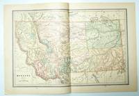
1889 Color Map of the State of Montana
by Cram, Geo. F.
- Used
- very good
- first
- Condition
- Used - Very Good
- Edition
- First Edition Thus
- Quantity Available
- 1
- Seller
-
Ladysmith, British Columbia, Canada
- Item Price
-
NZ$331.38NZ$28.87 shipping to USA
Show Details
Item Price
NZ$331.38
NZ$28.87
shipping to USA
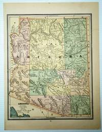
1889 Color Map of the State of Arizona
by Cram, Geo. F.
- Used
- very good
- first
- Condition
- Used - Very Good
- Edition
- First Edition Thus
- Quantity Available
- 1
- Seller
-
Ladysmith, British Columbia, Canada
- Item Price
-
NZ$331.38NZ$28.87 shipping to USA
Show Details
Description:
Rochester, NY: W.H. Stewart, 1889. Book. Illus. by Cram, Geo. F.. Very Good. Map. First Edition Thus. Folio - over 12" - 15" tall. Outer dimensions: 10.75" x 14.5". Counties individually colored. Clean and unmarked with light wear. An attractive vintage copy. Bonus: includes separate extensive list of Arizona counties and cities/towns, complete with their (1889) populations..
Item Price
NZ$331.38
NZ$28.87
shipping to USA
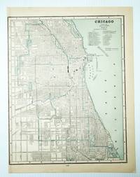
1889 Color City Map of Chicago, Illinois (IL)
by Cram, Geo. F.
- Used
- very good
- first
- Condition
- Used - Very Good
- Edition
- First Edition Thus
- Quantity Available
- 1
- Seller
-
Ladysmith, British Columbia, Canada
- Item Price
-
NZ$331.38NZ$28.87 shipping to USA
Show Details
Description:
Rochester, NY: W.H. Stewart, 1889. Book. Illus. by Cram, Geo. F.. Very Good. Map. First Edition Thus. Folio - over 12" - 15" tall. Outer dimensions: 10.75" x 14.5". Includes many street names. Principal buildings, steam roads and horse roads indicated. Clean and unmarked with light wear. An attractive vintage copy..
Item Price
NZ$331.38
NZ$28.87
shipping to USA
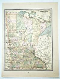
1889 Color Map of the State of Minnesota
by Cram, Geo. F.
- Used
- very good
- first
- Condition
- Used - Very Good
- Edition
- First Edition Thus
- Quantity Available
- 1
- Seller
-
Ladysmith, British Columbia, Canada
- Item Price
-
NZ$220.84NZ$28.87 shipping to USA
Show Details
Description:
Rochester, NY: W.H. Stewart, 1889. Book. Illus. by Cram, Geo. F.. Very Good. Map. First Edition Thus. Folio - over 12" - 15" tall. Outer dimensions: 10.75" x 14.5". Counties individually colored. Clean and unmarked with light wear. An attractive vintage copy..
Item Price
NZ$220.84
NZ$28.87
shipping to USA
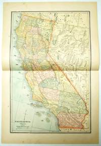
1889 Color Map of the State of California
by Cram, Geo. F.
- Used
- very good
- first
- Condition
- Used - Very Good
- Edition
- First Edition Thus
- Quantity Available
- 1
- Seller
-
Ladysmith, British Columbia, Canada
- Item Price
-
NZ$594.79NZ$28.87 shipping to USA
Show Details
Description:
Rochester, NY: W.H. Stewart, 1889. Book. Illus. by Cram, Geo. F.. Very Good. Map. First Edition Thus. Folio - over 12" - 15" tall. Outer dimensions: 21.75" x 14.5". Counties individually colored. Clean and unmarked with light wear. An attractive vintage copy. Bonus: includes separate extensive list of California counties and cities/towns, complete with their (1889) populations..
Item Price
NZ$594.79
NZ$28.87
shipping to USA
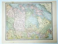
1889 Colour Map of the Dominion of Canada
by Cram, Geo. F.
- Used
- very good
- first
- Condition
- Used - Very Good
- Edition
- First Edition Thus
- Quantity Available
- 1
- Seller
-
Ladysmith, British Columbia, Canada
- Item Price
-
NZ$424.77NZ$28.87 shipping to USA
Show Details
Description:
Rochester, NY: W.H. Stewart, 1889. Book. Illus. by Cram, Geo. F.. Very Good. Map. First Edition Thus. Folio - over 12" - 15" tall. Outer dimensions: 10.75" x 14.5". Unmarked with light wear. A quality vintage copy..
Item Price
NZ$424.77
NZ$28.87
shipping to USA
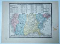
1889 Color Map of the Lower 48 States of the United States (U.S.A.) Indicating Divisions of Standard Time
by Artist Unknown
- Used
- very good
- first
- Condition
- Used - Very Good
- Edition
- First Edition Thus
- Quantity Available
- 1
- Seller
-
Ladysmith, British Columbia, Canada
- Item Price
-
NZ$169.86NZ$28.87 shipping to USA
Show Details
Description:
Rochester, NY: W.H. Stewart, 1889. Book. Very Good. Map. First Edition Thus. Folio - over 12" - 15" tall. Vintage color map. Includes table of cities located in the Inter-Colonial, Eastern, Central, Mountain, and Pacific Standard Time Zones. Indicates how many minutes faster or slower these locations are than Solar Time. Outer dimensions: 10.75" x 14.5". Unmarked with moderate wear and soiling..
Item Price
NZ$169.86
NZ$28.87
shipping to USA

1889 Colored Map of the Oklahoma Country in the Indian Territory
by Cram, Geo. F.
- Used
- very good
- first
- Condition
- Used - Very Good
- Edition
- First Edition Thus
- Quantity Available
- 1
- Seller
-
Ladysmith, British Columbia, Canada
- Item Price
-
NZ$1,274.55NZ$28.87 shipping to USA
Show Details
Description:
Rochester, NY: W.H. Stewart, 1889. Book. Illus. by Cram, Geo. F.. Very Good. Map. First Edition Thus. Folio - over 12" - 15" tall. Outer dimensions: 10.75" x 14.5". Clean and unmarked with light wear. An attractive vintage copy..
Item Price
NZ$1,274.55
NZ$28.87
shipping to USA

1889 Color Map of the State of Pennsylvania
by Cram, Geo. F.
- Used
- very good
- first
- Condition
- Used - Very Good
- Edition
- First Edition Thus
- Quantity Available
- 1
- Seller
-
Ladysmith, British Columbia, Canada
- Item Price
-
NZ$339.80NZ$28.87 shipping to USA
Show Details
Description:
Rochester, NY: W.H. Stewart, 1889. Book. Illus. by Cram, Geo. F.. Very Good. Map. First Edition Thus. Folio - over 12" - 15" tall. Vintage state map with counties individually colored. Outer dimensions: 21.75" x 14.5". Unmarked with light wear. Center fold. A quality example. Bonus: includes separate extensive list of counties and towns/cities of Pennsylvania, indicating (1889) population of each..
Item Price
NZ$339.80
NZ$28.87
shipping to USA
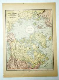
1889 Color Map of the (North) Polar Regions - Showing the Recent Arctic Discoveries
by Cram, Geo. F.
- Used
- very good
- first
- Condition
- Used - Very Good
- Edition
- First Edition Thus
- Quantity Available
- 1
- Seller
-
Ladysmith, British Columbia, Canada
- Item Price
-
NZ$339.80NZ$28.87 shipping to USA
Show Details
Description:
Rochester, NY: W.H. Stewart, 1889. Book. Illus. by Cram, Geo. F.. Very Good. Map. First Edition Thus. Folio - over 12" - 15" tall. Outer dimensions: 10.75" x 14.5". Unmarked with light wear. Interestingly, the North Pole and its immediate vicinity are labelled as "Unknown Regions." A quality vintage copy..
Item Price
NZ$339.80
NZ$28.87
shipping to USA
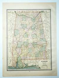
1889 Color Map of the State of Alabama
by Cram, Geo. F.
- Used
- very good
- first
- Condition
- Used - Very Good
- Edition
- First Edition Thus
- Quantity Available
- 1
- Seller
-
Ladysmith, British Columbia, Canada
- Item Price
-
NZ$169.86NZ$28.87 shipping to USA
Show Details
Description:
Rochester, NY: W.H. Stewart, 1889. Book. Illus. by Cram, Geo. F.. Very Good. Map. First Edition Thus. Folio - over 12" - 15" tall. Outer dimensions: 10.75" x 14.5". Counties individually colored. Clean and unmarked with light wear. An attractive vintage copy..
Item Price
NZ$169.86
NZ$28.87
shipping to USA
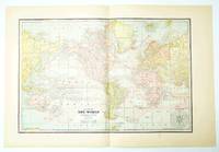
1889 Color Chart (Map) of the World on Mercator's Projection
by Cram, Geo. F.
- Used
- very good
- first
- Condition
- Used - Very Good
- Edition
- First Edition Thus
- Quantity Available
- 1
- Seller
-
Ladysmith, British Columbia, Canada
- Item Price
-
NZ$339.80NZ$28.87 shipping to USA
Show Details
Description:
Rochester, NY: W.H. Stewart, 1889. Book. Illus. by Cram, Geo. F.. Very Good. Map. First Edition Thus. Folio - over 12" - 15" tall. Outer dimensions: 21.75" x 14.5". Ocean currents indicated. Clean and unmarked with light wear. A quality vintage copy..
Item Price
NZ$339.80
NZ$28.87
shipping to USA
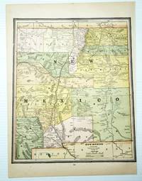
1889 Color Map of the State of New Mexico
by Cram, Geo. F.
- Used
- very good
- first
- Condition
- Used - Very Good
- Edition
- First Edition Thus
- Quantity Available
- 1
- Seller
-
Ladysmith, British Columbia, Canada
- Item Price
-
NZ$169.86NZ$28.87 shipping to USA
Show Details
Description:
Rochester, NY: W.H. Stewart, 1889. Book. Illus. by Cram, Geo. F.. Very Good. Map. First Edition Thus. Folio - over 12" - 15" tall. Outer dimensions: 10.75" x 14.5". Counties individually colored. Clean and unmarked with light wear. An attractive vintage copy..
Item Price
NZ$169.86
NZ$28.87
shipping to USA
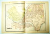
1889 Color Map of Pittsburgh, Pennsylvania (PA) and Allegheny City
by Cram, Geo. F.
- Used
- very good
- first
- Condition
- Used - Very Good
- Edition
- First Edition Thus
- Quantity Available
- 1
- Seller
-
Ladysmith, British Columbia, Canada
- Item Price
-
NZ$339.80NZ$28.87 shipping to USA
Show Details
Description:
Rochester, NY: W.H. Stewart, 1889. Book. Illus. by Cram, Geo. F.. Very Good. Map. First Edition Thus. Folio - over 12" - 15" tall. Outer dimensions: 21.75" x 14.5". Includes many street names. Clean and unmarked with light wear. An attractive vintage copy..
Item Price
NZ$339.80
NZ$28.87
shipping to USA

1889 Color Map of Wisconsin and Michigan
by Cram, Geo. F.
- Used
- very good
- first
- Condition
- Used - Very Good
- Edition
- First Edition Thus
- Quantity Available
- 1
- Seller
-
Ladysmith, British Columbia, Canada
- Item Price
-
NZ$254.83NZ$28.87 shipping to USA
Show Details
Description:
Rochester, NY: W.H. Stewart, 1889. Book. Illus. by Cram, Geo. F.. Very Good. Map. First Edition Thus. Folio - over 12" - 15" tall. Vintage state map with counties individually colored. Outer dimensions: 21.75" x 14.5". Unmarked with light wear. Center fold. A quality example. Bonus: includes separate extensive list of counties and towns/cities of Michigan, indicating (1889) population of each..
Item Price
NZ$254.83
NZ$28.87
shipping to USA
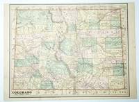
1889 Color Map of the State of Colorado
by Cram, Geo. F.
- Used
- very good
- first
- Condition
- Used - Very Good
- Edition
- First Edition Thus
- Quantity Available
- 1
- Seller
-
Ladysmith, British Columbia, Canada
- Item Price
-
NZ$254.83NZ$28.87 shipping to USA
Show Details
Description:
Rochester, NY: W.H. Stewart, 1889. Book. Illus. by Cram, Geo. F.. Very Good. Map. First Edition Thus. Folio - over 12" - 15" tall. Outer dimensions: 10.75" x 14.5". Counties individually colored. Clean and unmarked with light wear. An attractive vintage copy..
Item Price
NZ$254.83
NZ$28.87
shipping to USA
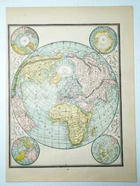
1889 Color Map of the World
by Cram, Geo. F.
- Used
- very good
- first
- Condition
- Used - Very Good
- Edition
- First Edition Thus
- Quantity Available
- 1
- Seller
-
Ladysmith, British Columbia, Canada
- Item Price
-
NZ$169.86NZ$28.87 shipping to USA
Show Details
Description:
Rochester, NY: W.H. Stewart, 1889. Book. Illus. by Cram, Geo. F.. Very Good. Map. First Edition Thus. Folio - over 12" - 15" tall. Outer dimensions: 10.75" x 14.5". Unmarked with light wear. Color corner illustrations indicate the globe's greatest mass of land, greatest mass of water, north pole regions, and south pole regions. A quality vintage copy..
Item Price
NZ$169.86
NZ$28.87
shipping to USA

1889 Color Map of the States of Virginia and West Virginia
by Cram, Geo. F.
- Used
- very good
- first
- Condition
- Used - Very Good
- Edition
- First Edition Thus
- Quantity Available
- 1
- Seller
-
Ladysmith, British Columbia, Canada
- Item Price
-
NZ$254.83NZ$28.87 shipping to USA
Show Details
Description:
Rochester, NY: W.H. Stewart, 1889. Book. Illus. by Cram, Geo. F.. Very Good. Map. First Edition Thus. Folio - over 12" - 15" tall. Vintage state map with counties individually colored. Outer dimensions: 21.75" x 14.5". Unmarked with light wear. Center fold. A quality example. Bonus: includes separate extensive list of counties and towns/cities for each state, indicating (1889) population of each..
Item Price
NZ$254.83
NZ$28.87
shipping to USA
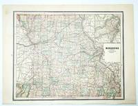
1889 Color Map of the State of Missouri
by Cram, Geo. F.
- Used
- very good
- first
- Condition
- Used - Very Good
- Edition
- First Edition Thus
- Quantity Available
- 1
- Seller
-
Ladysmith, British Columbia, Canada
- Item Price
-
NZ$254.83NZ$28.87 shipping to USA
Show Details
Description:
Rochester, NY: W.H. Stewart, 1889. Book. Illus. by Cram, Geo. F.. Very Good. Map. First Edition Thus. Folio - over 12" - 15" tall. Outer dimensions: 10.75" x 14.5". Counties individually colored. Clean and unmarked with light wear. A quality vintage copy. Bonus: includes separate extensive list of Missouri counties and cities/towns, complete with (1889) population of each..
Item Price
NZ$254.83
NZ$28.87
shipping to USA
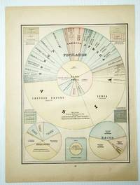
1889 Color Pie Charts of World Population By Country, Continent, Religion and Race
by Cram, Geo. F.
- Used
- very good
- first
- Condition
- Used - Very Good
- Edition
- First Edition Thus
- Quantity Available
- 1
- Seller
-
Ladysmith, British Columbia, Canada
- Item Price
-
NZ$254.83NZ$28.87 shipping to USA
Show Details
Description:
Rochester, NY: W.H. Stewart, 1889. Book. Illus. by Cram, Geo. F.. Very Good. Map. First Edition Thus. Folio - over 12" - 15" tall. Outer dimensions: 10.75" x 14.5". A fascinating and informative presentation of the population of the world in 1889. Main pie chart breaks illustrates the world's population by country and continent. Smaller pie charts present world population by religion and race. Clean and unmarked with light wear. A quality vintage copy..
Item Price
NZ$254.83
NZ$28.87
shipping to USA

Didn’t find what you’re looking for?
Try adding this search to your want list. Millions of books are added to our site everyday and when we find one that matches your search, we’ll send you an email. Best of all, it’s free.
Add to Want List

Are you a frequent reader or book collector?
Join the Bibliophile's Club and save 10% on every purchase, every day — up to $20 savings per order!

Social Responsibility
Did you know that since 2004, Biblio has used its profits to build 16 public libraries in rural villages of South America?
