Description:
London,: at Tycho Brahe's Head, No 60. in Fleet-Street,, [c1775 or earlier].. 216 by 273mm. (8.5 by 10.75 inches).. Prints,""George Adams, Mathematical Instrument-Maker to his Majesty, Trade card for the Adams family Printed letterpress broadside with engraved vignette of Tycho Brahe, manuscript bill in ink on verso, modern perspex cover. The Adams family were the pre-eminent British instrument makers of their day. The broadside lists instruments for use in astronomy, surveying, drawing, and navigation. In the centre is a vignette of the Adams shop sign, a portrait of Tycho Brahe. Brahe (1546-1601) was a Danish astronomer, pioneer in the field of scientific instruments and observation, and eccentric. After losing his nose in a duel while a student at the University of Rostock, he returned determined to be a scientist,and made important observations of Cassiopeia. Frederick II of Denmark granted him an estate in Hven to set up an observatory, where he compiled a star catalogue, observed the comet of…
Read More Search Results: Authors starting with A from Daniel Crouch Rare Books Ltd
You searched for:
- Bookseller inventory: Daniel Crouch Rare Books Ltd (authors starting with A)
- Bookseller: Daniel Crouch Rare Books Ltd
Results 1 - 20 of 70

... Makes and Sells all Sorts of the most curious Mathematical, Philosophical, and Optical Instruments, in Silver, Brass, Ivory or Wood, with the Utmost Accuracy and Exactness, according to the latest and best Discoveries of the modern Mathematicians.
by ADAMS Jnr, George; Dudley ADAMS; and [? George ADAMS Snr]
- Used
- Signed
- Condition
- Used
- Quantity Available
- 1
- Seller
-
London, United Kingdom
- Item Price
-
NZ$21,263.00NZ$31.89 shipping to USA
Show Details
Item Price
NZ$21,263.00
NZ$31.89
shipping to USA

Charte von Japan mit seinem VII Provinzen nach Robert's Entwurfe: A German reprint after Gilles Robert de Vaugondy
by After DE VAUGONDY, Gilles Robert
- Used
- Condition
- Used
- Quantity Available
- 1
- Seller
-
London, United Kingdom
- Item Price
-
NZ$372.10NZ$31.89 shipping to USA
Show Details
Description:
Weimar,: im Verlage des Geog. Institute,, 1811.. 200 by 242mm. (7.75 by 9.5 inches).. Engraved map. A map of Japan; a German reprint after Gilles Robert de Vaugondy, with the coast of Korea greatly simplified and an altered title cartouche. De Vaugondy's original was produced for the 'Atlas Universel'. See Hubbard 101 for original.
Item Price
NZ$372.10
NZ$31.89
shipping to USA

Panorama de Londres vu de la Nacelle d'un Ballon: A French version of Havell's Aeronautical View
by [after HAVELL Jnr., Robert]
- Used
- Condition
- Used
- Quantity Available
- 1
- Seller
-
London, United Kingdom
- Item Price
-
NZ$7,442.05NZ$31.89 shipping to USA
Show Details
Description:
Paris,: Le Roi, Place de Louvre No. 8,, [c.1840].. Image: 255 by 990mm (10 by 39 inches). Sheet: 315 by 1040mm (12.5 by 41 inches).. Engraving with aquatint. References in French, without key numbers, in lower margin. A close copy of Havell's 'Aeronautical View...'. Rare. We have only been able to trace four other examples of this print; item 25, a coloured example in a private collection, and the institutional examples held by the Guildhall Library and Westminster Art Collection.
Item Price
NZ$7,442.05
NZ$31.89
shipping to USA
![[Panorama de Londres vu de la Nacelle d'un Ballon].](https://d3525k1ryd2155.cloudfront.net/h/762/909/1162909762.0.m.0.jpg)
[Panorama de Londres vu de la Nacelle d'un Ballon].: A colour version of Havell's Aeronautical View
by [after HAVELL Jnr., Robert]
- Used
- Condition
- Used
- Quantity Available
- 1
- Seller
-
London, United Kingdom
- Item Price
-
NZ$6,378.90NZ$31.89 shipping to USA
Show Details
Description:
Paris,: Le Roi, Place de Louvre No. 8,, [c.1840].. Image: 270 by 996mm (10.75 by 39.25 inches).. Engraved print with fine contemporary colour, trimmed within platemark, with black wash borders. A close copy of Havell's 'Aeronautical View...' and a trimmed, coloured, example of its French copy.
Item Price
NZ$6,378.90
NZ$31.89
shipping to USA

Winter Vreugde op den Amftel en't gaan des Ysbreekers en der Waterfchuiten.: Skating on the Amstel
by [After HORST, Tieleman van der]
- Used
- Condition
- Used
- Quantity Available
- 1
- Seller
-
London, United Kingdom
- Item Price
-
NZ$9,568.35NZ$31.89 shipping to USA
Show Details
Description:
Amsterdam,: Petrus Schenk,, [1730].. 625 by 925mm. (24.5 by 36.5 inches).. Etching and engraving on two sheets joined. A large winter scene from the Amstel dike towards Weesp. The scene is replete with a wealth of activity on the frozen water, with among other things skaters, carriages, sledges, a cafe on the ice, andmost notably a horse-drawn icebreaker. The icebreakers kept the Amstel open by order of the beer brewers to provide for fresh drinking water from the Vecht river. At bottom left and right descriptions in Dutch and French about the icebreakers. On the far left is the entrance to the 'Oliphantspad'; to the right the 'Lokhorst' and the tavern the 'Ysbreker''. The engraver of the work is unknown, however, the piece was sometimes bound into the 'Theatrum Machinarum
' by Tieleman van der Horst, which was published by Pieter Schenk in 1739. Tieleman van der Horst was an eighteenth century Dutch civil engineer. Bierens de Haan 4840.
Item Price
NZ$9,568.35
NZ$31.89
shipping to USA

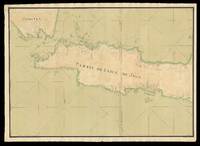
Scotland: John Ainslie's Landmark Map of Scotland Drawn and Engrav'd from a Series of Angles and Astronomical Observations By John Ainslie Land Surveyor.
by AINSLIE, John
- Used
- Condition
- Used
- Quantity Available
- 1
- Seller
-
London, United Kingdom
- Item Price
-
NZ$10,631.50NZ$31.89 shipping to USA
Show Details
Description:
Edinburgh & London,: Printed & Sold by Thomas Brown; William Faden, Geographer to the King, Charing Cross, , Jan[uar]y 1st 1800.. 1770 by 1590mm. (69.75 by 62.5 inches).. Large engraved map on nine sheets, fine original full-wash hand-colour, dissected and mounted on linen, in four sections, insets of the Shetland and Orkney Isles, table of distances between towns, and heights of the 'Most Remarkable Hills', lower left. Ainslie's large and detailed map of Scotland. First published in 1789, this large and rare map would become the benchmark map of Scotland, until Aaron Arrowsmith's map of Scotland some 20 years later. The map is on the same scale (approx. 4 inches to 1 mile) as Dorret's map of 1750, however, it surpasses it in terms of clarity and accuracy; and for the first time the Great Glen from Inverness to Fort William is accurately depicted, as are many of the islands that make up the Western Isles. John Ainslie (1745-1828) was, without doubt, the outstanding Scottish cartographer of his…
Read More Item Price
NZ$10,631.50
NZ$31.89
shipping to USA

Scotland: First edition of John Ainslie's Landmark Map of Scotland Drawn and Engrav'd from a Series of Angles and Astronomical Observations By John Ainslie Land Surveyor.
by AINSLIE, John
- Used
- Condition
- Used
- Quantity Available
- 1
- Seller
-
London, United Kingdom
- Item Price
-
NZ$12,757.80NZ$31.89 shipping to USA
Show Details
Description:
Edinburgh & London,: Printed & Sold by John & James Ainslie Booksellers & Stationers, St. Andrew's Street Newtown; William Faden, Geographer to the King, Charing Cross,, Jan 1st 1789.. 1770 by 1590mm. (69.75 by 62.5 inches).. Large engraved map on nine sheets, fine original full-wash hand-colour, dissected and mounted on linen, insets of the Shetland and Orkney Isles, table of distances between towns, and heights of the 'Most Remarkable Hills', lower left. Ainslie's large and detailed map of Scotland. First published in 1789, this large and rare map would become the benchmark map of Scotland, until Aaron Arrowsmith's map of Scotland some 20 years later. The map is on the same scale (approx. 4 inches to 1 mile) as Dorret's map of 1750, however, it surpasses it in terms of clarity and accuracy; and for the first time the Great Glen from Inverness to Fort William is accurately depicted, as are many of the islands that make up the Western Isles. John Ainslie (1745-1828) was, without doubt, the…
Read More Item Price
NZ$12,757.80
NZ$31.89
shipping to USA

Vue du Pont de Westminster: Westminster Bridge d'aprés le Tableau original, qui est dans le Cabinet de M.F. Drouhin 1799.
by ALIX, P[ierre] M[ichel]
- Used
- Condition
- Used
- Quantity Available
- 1
- Seller
-
London, United Kingdom
- Item Price
-
NZ$2,019.99NZ$31.89 shipping to USA
Show Details
Description:
[Paris],: Pierre-Michel Alix,, 1799.. Image: 410 by 615mm (16.25 by 24.25 inches). Sheet: 440 by 630mm (17.25 by 24.75 inches).. Aquatint with original hand colour. A view of Westminster Bridge, after a painting owned by Marie-Francois Drouhin, a Parisian printer. Pierre Michel Alix (1762-1817) was a French engraver and caricaturist, active in Paris, who made a successful career during the French Revolution producing prints of revolutionary leaders and allegories. He quietly destroyed these when the Revolution foundered and was later well known for a print of Napoleon as Emperor. BM 1880,1113.1328.
Item Price
NZ$2,019.99
NZ$31.89
shipping to USA

Publishers of the greatest variety of Sporting Prints, & rudimental Works on the Art of Drawing
by ALKEN, Henry; Samuel Williams FULLER; and Joseph Carr FULLER
- Used
- Condition
- Used
- Quantity Available
- 1
- Seller
-
London, United Kingdom
- Item Price
-
NZ$1,275.78NZ$31.89 shipping to USA
Show Details
Description:
London,: 34 Rathbone Place, , [c1821-1822]. 140 by 165mm (5.5 by 6.5 inches).. Prints,""S & J. Fuller, Carvers, Gilders, & Picture Frame Makers... C is for Carver Lithographed trade card The image is a hopeless hunting scene after Henry Thomas Alken (1785-1851), from the 'The Right Sort' series, published by the Fullers in 1821-1822. Alken's first sporting prints were published in 1813, but he hit his stride in about 1816 when he published his best-selling 'The Beauties and Defects in the Figure of the Horse Comparatively Delineated', after which he was positively prolific, issuing many series of hunting sketches by publishers including the Fullers, Thomas McLean, and Rudolph Ackermann. Self-advertised elsewhere as: """"Printsellers and publishers, stationers, artists' colourmen, playing-card makers"""", the partnership of Samuel Williams Fuller (c1777-1857) and Joseph Carr Fuller (c1782-1863) was established by 1809 when it operated from the """"Temple of Fancy"""" at 34 Rathbone Place, as here.…
Read More Item Price
NZ$1,275.78
NZ$31.89
shipping to USA

More Photos
Dobbs & Co.'s Relievo Maps, Drawn & Engraved from the Highest Official Authorities. Geological Map of England & Wales.: Rare Embossed Geological map of England and Wales Arranged by permission from an Improved Index Map by R.I. Murchison Esqr. F.R.S. Resid[en]t of Geological S[ocie]ty.
by DOBBS & Co
- Used
- Hardcover
- Condition
- Used
- Binding
- Hardcover
- Quantity Available
- 1
- Seller
-
London, United Kingdom
- Item Price
-
NZ$8,505.20NZ$31.89 shipping to USA
Show Details
Description:
London,: Published by Dobbs & Co., 134 Fleet St. & 13 Soho Sqre. Sold also by D. Bogue Fleet St. and All Print and Mapsellers,, [1843].. 545 by 450mm (21.5 by 17.75 inches).. Embossed geological map, fine original hand-colour, table of geological strata upper left, table of English counties upper right, dissected and mounted on card and linen, varnished, some minor abrasions, Kensington and Camberwell library stamps to map, folding into original embossed red cloth covers, title in gilt to upper cover, spine spilt. Rare embossed geological map of England and Wales. The map's geological information is based upon Roderick Impey Murchison's map of the 1843. However, the present maps innovation is in representing elevation above sea level with the use of embossing. In order to ascertain the approximate heights above sea level, a "Vertical Scale" key, has been added below the list of English and Welsh counties. The key depicts cross sections of mountain ranges from under 700 feet to between 2800-3500 feet…
Read More Item Price
NZ$8,505.20
NZ$31.89
shipping to USA

More Photos
A new, authentic, and complete Edition of Captain Cook's Voyages round the World. Undertaken and performed by Royal Authority. Containing the Whole of his first, second, third, and last Voyages...: Cook in Parts!
by ANDERSON, George William pseud.
- Used
- Condition
- Used
- Quantity Available
- 1
- Seller
-
London, United Kingdom
- Item Price
-
NZ$1,594.73NZ$31.89 shipping to USA
Show Details
Description:
London,: Printed for Alex. Hogg
and sold by all other Booksellers and News-carriers in the World,, [c1785].. Folio (416 by 268 mm), pp 361368, with text in double columns and two accompanying copperplate etchings ('A Human Sacrifice, in a Morai, in Otaheithe; in the presence of CaptN. Cook etc.' by Lodge; 'Mr. Doughty beheaded by order of Sir Francis Drake, at port St. Indian, on the Coast of Patagonia' by Goldar after Dodd); uncut in the original blue printed wrappers, creased where previously folded, edges a little ragged, spine chipped, but stitching intact. This folio contains the 44th installment of the account of Captain Cook's voyages produced by G.W.Anderson in 1785. During his three great voyages on HMS Endeavour, Resolution, Adventure and Discovery, Captain James Cook made a revolutionary contribution to the geographical understanding of the Southern Hemisphere. Unsurprisingly, upon his return the public appetite for the stories of his adventures was huge. In response to this…
Read More Item Price
NZ$1,594.73
NZ$31.89
shipping to USA

Japan.: From the fourth edition of 'Andrees Allgemeiner Handatlas
by [ANDREES, Richard]
- Used
- Condition
- Used
- Quantity Available
- 1
- Seller
-
London, United Kingdom
- Item Price
-
NZ$85.05NZ$31.89 shipping to USA
Show Details
Description:
[Bielefeld and Leipzig,: Velhagen & Klasing,, 1898].. 440 by 280mm (17.25 by 11 inches).. Chromolithograph map. Published in the fourth edition of 'Andrees Allgemeiner Handatlas'. Velhagen & Klasing was a major German publishing company in the nineteenth and twentieth centuries. In the mid-to-late 1800s, Hirt & Sohn and Velhagen & Klasing together had an oligopoly in the German textbook market
Item Price
NZ$85.05
NZ$31.89
shipping to USA

A Topographical Map of Hertfordshire: Hertfordshire - Rare large-scale map of Hertfordshire from an Actual Survey; in which is Expressed all the roads, lanes, churches, noblemen, and gentlemen's - seats, and every thing remarkable in the County: together with the divisions of the parishes. By
by ANDREWS, John [and] Andrew DURY
- Used
- Hardcover
- Condition
- Used
- Binding
- Hardcover
- Quantity Available
- 1
- Seller
-
London, United Kingdom
- Item Price
-
NZ$10,631.50NZ$31.89 shipping to USA
Show Details
Description:
London,: William Faden Charing Cross,, 1st January, 1782.. 1550 by 2120mm (61 by 83.5 inches).. Folio (550 by 400mm), index map, large-scale engraved map, on nine sheets, fine original full-wash colour, plan of Hertford, and plan of St Albans, half-calf over blue marbled paper boards. Andrews's and Dury's large scale map of Hertfordshire. John Andrews and Andrew Dury were responsible for three large scale eighteenth century county surveys: the present map - Hertfordshire 1766 , Kent 1769, and Wiltshire in 1773. All three surveys are on a scale of two inches to one mile. The majority of the large scale maps were on a scale of one inch to one mile. This larger scale allowed for much greater detail; and the map depicts hills, woods and barrows, commons heaths and parks, rivers, ponds and wells, bridges and windmills, churches and chapels, towns, villages and parishes, gentlemen's seats, farms and houses, turnpikes, secondary roads and lanes, county and hundred boundaries. A note on the map reads "NB…
Read More Item Price
NZ$10,631.50
NZ$31.89
shipping to USA
![A Present from [the] Isle of Man.](https://d3525k1ryd2155.cloudfront.net/h/897/506/1391506897.0.m.jpg)
A Present from [the] Isle of Man.: Isle of Man
by [Anonymous]
- Used
- Hardcover
- Condition
- Used
- Binding
- Hardcover
- Quantity Available
- 1
- Seller
-
London, United Kingdom
- Item Price
-
NZ$744.20NZ$31.89 shipping to USA
Show Details
Description:
[20th century].. 555 by 555mm. (21.75 by 21.75 inches).. Map printed on cloth, some spotting. Unusual map of the Isle of Man, printed on cloth, presumably as a souvenir ("A Present From"). The map shows the roads, railways and topographical detail. It is surrounded by views of Kirk Braddan, the Tower of Refuge, the Laxey Wheel and the seafront. The two symbols of the Isle of Man, the Manx cat and the triskelion of three legs joined together, are shown at either end of the island.
Item Price
NZ$744.20
NZ$31.89
shipping to USA
More Photos
Partie De L'Isle De Java - Suite De L'Isle De Iava: French manuscript chart of Java - the heart of the Dutch empire
by [ANONYMOUS]
- Used
- Condition
- Used
- Quantity Available
- 1
- Seller
-
London, United Kingdom
- Item Price
-
NZ$69,104.75NZ$31.89 shipping to USA
Show Details
Description:
[Probably Paris,: Dépôt des cartes et plans de la Marine,, c1733-1739].. 530 by 1500mm. (20.75 by 59 inches), overall. Manuscript chart, pen and black ink and colour wash, on two separate sheets of paper watermarked with Strasburg Lily within a shield, initials "VDL" beneath and countermark "IV" (closest to Churchill 405, dated to 1733, from the mill of Pieter van der Ley, son of Gerrit Pieters van der Ley who worked De Wever - the Weaver - and De Bonsem - the Polecat - mills at Koog aan de Zaan, Holland, from 1674 onwards). The conquest of Jakarta by the Dutch, who immediately renamed the port Batavia, in 1619, gave the VOC its Asian headquarters, from which it commanded a vast trading empire, eventually extending from southern Africa to Japan, that lasted for nearly two hundred years. By the end of the 1730s, the British and French had begun to flex their seafaring muscles in the area, and were publishing their own maps. This large-scale and detailed French chart of Java is clear evidence of a…
Read More Item Price
NZ$69,104.75
NZ$31.89
shipping to USA
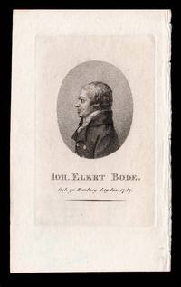
Geb. zu Hamburg d. 19 Jan 1747.
by [ANONYMOUS]
- Used
- Condition
- Used
- Quantity Available
- 1
- Seller
-
London, United Kingdom
- Item Price
-
NZ$637.89NZ$31.89 shipping to USA
Show Details
Description:
[Weimar,: Friedrich Justin Bertuch,, 1807].. 140 by 90mm. (5.5 by 3.5 inches).. Prints,""Joh. Elert Bode. Johann Elert Bode Stipple-engraved portrait. Volume 23 of the 'Allgemeine Geographische Ephemeriden' published in 1807 contained a portrait of German astronomer Johann Elert Bode (1747 - 1826). As director of the Berlin Observatory, Bode named Uranus after it was determined to be a planet in 1783. His star atlas of 1801, which he named the 'Uranographia', was the largest to date and contained the positions of more than 17,000 stars. In fact, it was one of the last scientific astronomic atlases to depict the traditional figures for constellations. His portrait in the """"AGE"""" shows Bode wearing a formal coat and cravat. His profile positioning was probably intended to hide the obvious damage done in his youth to his right eye by a disease. Beneath the portrait, set in an oval, his name and date of death are given. Wellcome 338.
Item Price
NZ$637.89
NZ$31.89
shipping to USA
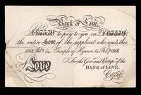
Bank of Love. Promise (67579) to pay to you on demand (67579) the entire Love of the supplicant who sends this. 1868 Feb.y. 14. Temple of Hymen 14 Feb.y 1868. For the Gov.r and Compy:a of the Bank of Love. Cupid.: Cashing in at the Bank of Love
by [ANONYMOUS]
- Used
- Condition
- Used
- Quantity Available
- 1
- Seller
-
London, United Kingdom
- Item Price
-
NZ$1,063.15NZ$31.89 shipping to USA
Show Details
Description:
[London,, 1868].. 130 by 210mm. (5 by 8.25 inches).. Bank note, creased, a few tears skilfully repaired. A Valentine's Day promissory note, published for the 14th February, 1868. The note is in the form of the five pound bank notes issued by the Bank of England in the nineteenth century. Whereas the bank of England promised to pay the bearer of the note five pounds worth of gold. The bear of this note can expect "the entire Love of the supplicant who sends this". The note is endorsed by none other than Cupid, Chairman of the Bank of Love, who's head office is located at the Temple of Hymen.
Item Price
NZ$1,063.15
NZ$31.89
shipping to USA
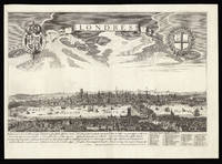
Londres.: A French variant of De Jonghe's view of London
by [Anonymous]
- Used
- Condition
- Used
- Quantity Available
- 1
- Seller
-
London, United Kingdom
- Item Price
-
NZ$5,103.12NZ$31.89 shipping to USA
Show Details
Description:
Paris,: chez Jean Savué demeurant à la rue St. Jaques proche St. Yves à la libert,. 385 by 540mm. (15.25 by 21.25 inches).. Copper engraving. A French variant on De Jonghe's view of London, with the verses underneath in a different type and the name of the Thames translated into French from Latin. Jean Sauvé (1635-1692) was an engraver and publisher active in Paris, and known for re-engraving the works of others, including de Jonghe (as here), Merian, Tavernier, and Jollain.
Item Price
NZ$5,103.12
NZ$31.89
shipping to USA
D. der Arzneykunde und beruhmter Naturforscher geb. 1672 gest. 1733.
by [ANONYMOUS]
- Used
- Condition
- Used
- Quantity Available
- 1
- Seller
-
London, United Kingdom
- Item Price
-
NZ$318.94NZ$31.89 shipping to USA
Show Details
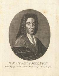
Description:
[Augsburg,: Bürglen,, 1805].. 185 by 144mm. (7.25 by 5.75 inches).. Prints,""J. J. Scheuchzerus Johann Jakob Scheuchzer Engraved portrait. Johann Jakob Scheuchzer (1672-1733) published 34 original works and numerous articles on the subjects of history, science and travel; his subscribers included some of the most notable names of the day, such as Isaac Newton and Hans Sloane. After extensive journeys throughout his native Switzerland, he published a four sheet map of the country in 1712, the same year that a civil war toppled the Old Swiss Confederacy and ended Catholic hegemony. Until the end of the eighteenth century, Scheuchzer's map was the most accurate cartographical representation of Switzerland in existence. Additionally, Scheuchzer was appointed senior town physician in Zurich in 1733, and for this reason his portrait was included in George Wihelm Zapf's 'Abbildungen berühmter & besonders', a collection of 180 portraits of famous physicians.
Item Price
NZ$318.94
NZ$31.89
shipping to USA
Londinum Londinum Urbs Praecipua Regni Angliae.: A Latin version of Aveline's view of London
by [Anonymous]
- Used
- Condition
- Used
- Quantity Available
- 1
- Seller
-
London, United Kingdom
- Item Price
-
NZ$3,189.45NZ$31.89 shipping to USA
Show Details
Description:
[Italy,, c1687-1730].. Image: 395 by 510mm (15.5 by 20 inches). Sheet: 430 by 555mm (17 by 21.75 inches).. Copper engraving. A Latin version of Pierre Aveline's view of London. Although the title cartouche has been changed, the engraver has not changed the tower of St Paul's Cathedral to its post-Fire state. Although it is intended to represent contemporary, eighteenth century London, it still shows the Elizabethan theatres in Bankside. Scouloudi records this as a variant of the view published by Antoine Aveline (1691-1743) in the early eighteenth century, but she does not record the copy published by his father, Pierre Aveline. The present example could therefore be a variant on either the father's or the son's. Scouloudi pp.59-60.
Item Price
NZ$3,189.45
NZ$31.89
shipping to USA

Didn’t find what you’re looking for?
Try adding this search to your want list. Millions of books are added to our site everyday and when we find one that matches your search, we’ll send you an email. Best of all, it’s free.
Add to Want List

Are you a frequent reader or book collector?
Join the Bibliophile's Club and save 10% on every purchase, every day — up to $20 savings per order!

Social Responsibility
Did you know that since 2004, Biblio has used its profits to build 16 public libraries in rural villages of South America?
