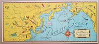
Skip to content

Search Results: Titles starting with M from BICKERSTAFF'S BOOKS, MAPS &C.

You searched for:
  • Bookseller inventory: BICKERSTAFF'S BOOKS, MAPS &C. (titles starting with M)
  • Bookseller: BICKERSTAFF'S BOOKS, MAPS &C.
Results 1 - 3 of 3
Map of Countries Visited in Air Adventures of Jimmie Allen.
More Photos

Map of Countries Visited in "Air Adventures of Jimmie Allen."

by [Pictorial Map: Asia and the Pacific.] Skelly Oil Co.

  • Used
Condition
Used
Quantity Available
1
Seller
Scarborough, Maine, United States
Seller rating:
This seller has earned a 5 of 5 Stars rating from Biblio customers.
Item Price
NZ$841.20
NZ$16.99 shipping to USA

Show Details

Description:
This delightful pictorial map focusing on the North Pacific Ocean was distributed as a premium in connection with the syndicated radio program, "Air Adventures of Jimmie Allen." The program, featuring Jimmie Allen as an adventurous 16-year old pilot, ran from 1933 to 1937 and from 1946 to 1947 and was sponsored initially by the Skelly Oil Company.

Background on the show appears on the Radio Days Theater of the Mind Museum website (http://radiodaysmuseum.org):
"Broadcast History: 1933 to 1937 and 1946 to 1947.
The writers of Jimmie Allen had been flying aces in World War I. They came up with the idea of a show about a boy pilot while at a party in Kansas City and used their experience as pilots to create and write the show.
The show was one of the first to capitalize on the idea of a club as a promotional tool. To join the Jimmie Allen Flying Club all a child had to do was apply at any Skelly Gas Station (the initial sponsor). As a member the child received a whole host of goodies ranging from a… Read More
Item Price
NZ$841.20
NZ$16.99 shipping to USA
Map of Dartmouth Coll: Present & Future.
More Photos

Map of Dartmouth Coll: Present & Future.

by [Dartmouth College.] [Pictorial Map.] L[arson], J[ens] F[redrick]

  • Used
Condition
Used
Quantity Available
1
Seller
Scarborough, Maine, United States
Seller rating:
This seller has earned a 5 of 5 Stars rating from Biblio customers.
Item Price
NZ$2,549.10
NZ$16.99 shipping to USA

Show Details

Description:
Delightful 1928 Pictorial Map of Dartmouth College
This wonderful pictorial map depicts the Dartmouth College campus in the late 1920s. It was apparently distributed to donors to the College's Alumni Fund. The artist, Jens Frederick Larson, served as Dartmouth's architect in residence from 1919 to 1947, during which period he was responsible for the design of Baker Library and the Tuck Mall. An uncommon map, with only two institutional holders noted on OCLC.Condition: Age darkened. On brittle paper with cracking and splits now corrected and stabilized with an archival tissue backing. Some staining in the margins. [ICN 3735.]
Item Price
NZ$2,549.10
NZ$16.99 shipping to USA
A Map of the White Mountains of New Hampshire 1853. [with] Mt. Washington from North Conway [and...
More Photos

A Map of the White Mountains of New Hampshire 1853. [with] Mt. Washington from North Conway [and four other views].

by [New Hampshire.] [White Mountains.] Bond, George and B[enjamin]. Champney.

  • Used
  • Hardcover
Condition
Used
Binding
Hardcover
Quantity Available
1
Seller
Scarborough, Maine, United States
Seller rating:
This seller has earned a 5 of 5 Stars rating from Biblio customers.
Item Price
NZ$1,656.92
NZ$16.99 shipping to USA

Show Details

Description:
White Mountains ClassicThe Bond map with the Champney views is without doubt one of the White Mountains classics. On the Bond map, "[t]he names of the individual peaks of the Presidential Range appear for the first time on any map, as well as the names Cannon Mt., Twin Mts., Carrigain, Tremont, and Giant's Stairs." ( Bent, p.84). Hachure marks are employed to suggest elevation, and Apt notes that this is the first topographic map of the region. The five lithographed views after Champney are printed on the reverse of the map as called for by Bent. Apt notes that map and views appear on separate sheets in some cases. We do not know the precedence or relative rarity of the two formats. The front paste-down provides a "Table of Distances" while the rear has a "Table of Heights, Bearings and Distances" of 30 peaks. References: Apt, Maps of the White Mountains of New Hampshire (Exhibition Catalogue): Map 14, pp. 9-10. Hanrahan [ed.], Bent's Bibliography of the White Mountains: p. 84.… Read More
Item Price
NZ$1,656.92
NZ$16.99 shipping to USA
Add to Want List

Didn’t find what you’re looking for?

Try adding this search to your want list. Millions of books are added to our site everyday and when we find one that matches your search, we’ll send you an email. Best of all, it’s free.

Add to Want List
Book lovers can save on books by joining our Bibliophiles club

Are you a frequent reader or book collector?

Join the Bibliophile's Club and save 10% on every purchase, every day — up to $20 savings per order!

Biblio is a socially responsible company

Social Responsibility

Did you know that since 2004, Biblio has used its profits to build 16 public libraries in rural villages of South America?