Description:
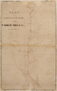
Details:S[ylvanus]. Bourne, Surveyormanuscript survey map, hand inked, with partial water color, a working map with some ink overwriting in a different handdimensions: 36 ¾" x 23 1/8"condition: original inks and water colors, cleaned, professionally conserved, original fabric backing removed, area of loss due to a hungry mouse filled, other paper loss filled, unbacked. Description:This undated manuscript
Plan of the Lands & Water of the Parker Mills Co. in Wareham, Mass. c. 1834? is a rare, new discovery that offers a detailed view of Wareham in its early industrial period. The scope of the Plan of the Lands and Water of the Parker Mills Co. (the "Plan")
is defined by the geographic scope of the property of one of Wareham's major iron and nail manufacturers, the Parker Mills Co., whose business history begins in the 1830's, and predate its 1845 legal incorporation by Act of the Massachusetts Legislature. The predecessor to the Parker Mills Co. was the Wareham Iron Co. (Tihonet Pond Upper Works… Read More


![[Pacific Ocean and South Seas 1838-1842, American Nautical Charts] Set of 15 navigation charts by](https://d3525k1ryd2155.cloudfront.net/h/975/200/1386200975.0.m.0.jpg)


