Click for full-size.

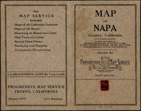
Napa County California. 1914
by Copyright 1914 by Punnett Brothers
- Used
- Condition
- See description
- Seller
-
FRAMINGHAM, Massachusetts, United States
Payment Methods Accepted
About This Item
Map Details and Condition:
color lithograph
dimensions: 26 3/4" x 19"
Brown Paper pocket covers with red bookstore label of Neal Stratford & Kerr, San Francisco
condition: professionally flattened and otherwise in as found, very good condition
Description:This 1914 map of now popular wine country Napa County, California shows the county in 1914, with early roads, largely undeveloped, vast open land areas, and natural features. The numbered grid system on this map reflects the Public Land Survey System. Large open tracts of land are identified as ranches, such as Rancho Catacoula, or Rancho Las Putas, Rancho LaJota all of which are large swaths of undivided land. Urban grids are shown in the southernmost part of Napa County, and sections of the southernmost sections of Sonoma County and Solano County. The cities of Petaluma, Sonoma, Vallejo and Napa and Benicia show populated urban areas. A corner of Marin County is shown.
C.F. Weber & Co. and the Punnett Brothers published several series of California county maps, of which this Nap California 1914 map is one. The map's key, or Explanation shows utilities, steam and electric trains, roads, wagon roads, trails, reclamation districts and irrigation projects. The map key in its way is also a history of land use in 19th and early 20th c. California with a range of transit from wagon to electric and steam train. By comparison, the Map of Tulare County California 1907 more resembles the 19th c., with long haul train routes and little other transportation, and few roads.
The 1914 map of Napa California captures the county in transition from undeveloped to rural and surrounded by rapidly urbanizing neighboring counties in the proximity of San Francisco. The map is accompanied by its original pocket covers. The pocket cover bears a little red label of the San Francisco bookstore run by Neal, Stratford & Kerr, a highly regarded letterpress printer in San Francisco. The Fine Arts Museum of San Francisco credits the firm with organizing in 1919. That would mean the label on this pocket cover was at the earliest placed on the map five years after the map was first published. This suggest that the 1914 edition of the map of Napa California was still relied upon in 1919. The firm Neal Stratford & Kerr made a radical change from full service printer to poster art printer in the 1960's for dance concerts. Please see the collections of the Fine Arts Museum of San Francisco.Reviews
(Log in or Create an Account first!)
Details
- Seller
- Original Antique Maps
 (US)
(US)
- Seller's Inventory #
- 304
- Title
- Napa County California. 1914
- Author
- Copyright 1914 by Punnett Brothers
- Book Condition
- Used
- Quantity Available
- 1
- Publisher
- Published by C.F. Weber & Co., San Francisco, Los Angeles
- Place of Publication
- San Francisco, California
- Date Published
- c. 1914
- Weight
- 0.00 lbs
- Keywords
- Napa California Map, Pocket Map California, Neal Stratford & Kerr, San Francisco printers, California maps early 20th c., California Land Use early 20th c.
Terms of Sale
Original Antique Maps
30 day return guarantee, with full refund including original shipping costs for up to 30 days after delivery if an item arrives misdescribed. If an item arrives damaged, please contact Original Antique Maps immediately to report the damage and discuss whether the original shipping materials may still be used to return the item and for return shipping instructions. Original Antique Maps will fully refund buyer's payments and pay for the return shipping of any damaged item. Buyer will be paid following receipt by Original Antique Maps of the returned item. Otherwise, returns as per www.spackantiquemaps.com.Buyer will be advised of shipping and handling charges that exceed standard charges to buyer.
About the Seller
Original Antique Maps
Biblio member since 2020
FRAMINGHAM, Massachusetts
About Original Antique Maps
Rare and unusual 18th and 19th century Americana, American and International maps, atlases, prints, nautical charts and manuscript maps. My interests include American 19th century newspapers and manuscript materials such as letters. Maps of the 20th c. including advertising, transit and urban planning are of special interest. Original art on paper in its many forms, including posters and field studies for ultimate print publication.
Glossary
Some terminology that may be used in this description includes:
- Fine
- A book in fine condition exhibits no flaws. A fine condition book closely approaches As New condition, but may lack the...
This Book’s Categories

Storing books - laying down or standing up?
Don’t unwittingly damage your growing book collection! Learn about when to store books laying down vs standing up. Read About Safe Book Storage
Also Recommended
-
-

-
-
-

Save 10% on every purchase!
Join the Bibliophiles’ Club and start saving 10% on every book.
$29.95 / Year