
Click for full-size.
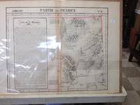
Atlas Universel De Geographie, Physique, Politique Et Mineralogique North America - Map of Eastern Nevada and Utah (Partie Du Mexique)
by Vandermaelen, Philippe
- Used
- very good
- Condition
- Very Good
- Seller
-
Nashville, Tennessee, United States
Payment Methods Accepted
About This Item
Brussels, Belgium: Lithographed By H. Ode. Very Good. 1827. Map. Map # 47, A Very Good primitive and early map of eastern Nevada, the State of Utah, also including part of northern Arizona and the Grand Canyon. The Great Salt Lake is shown, but further south and west than later surveyed to be. Of course, almost all localities shown are French or Indian names. Another large lake is shown, probably Bear Lake is shown in Nevada. The atlas from which this is extracted is extremely rare and originally composed 6 volumes, this map being from the North America volume. Lithographer Ode and Cartographer Vandermaelen produced the first lithographed atlas ever done. Condition is overall Very Good. Browning to the centerfold crease caused by glue used in attaching the tab to the original volume, the two page spread measures 21" x 26 1/2" when opened out. Approximately 1/3 of the map consists of a lengthy description in French of the Mexican territory which comprised Nevada and Utah. Other contiguous maps are shown as parts of the "New Mexico territory" but this map describes itself as part of Mexico as was California in 1824. Topigraphical features are accentuated, see image. Shipping will require extra care and cost due to insurance. Photo available upon request. ; 21" x 26 1/2"; 1 pages .
Reviews
(Log in or Create an Account first!)
Details
- Seller
- Elders Bookstore
 (US)
(US)
- Seller's Inventory #
- 36233
- Title
- Atlas Universel De Geographie, Physique, Politique Et Mineralogique North America - Map of Eastern Nevada and Utah (Partie Du Mexique)
- Author
- Vandermaelen, Philippe
- Format/Binding
- Map
- Book Condition
- Used - Very Good
- Quantity Available
- 1
- Publisher
- Lithographed By H. Ode
- Place of Publication
- Brussels, Belgium
- Date Published
- 1827
- Bookseller catalogs
- Maps;
- Note
- May be a multi-volume set and require additional postage.
Terms of Sale
Elders Bookstore
Returns by permission only, shipping costs are not included in any refunds. Restocking charges may apply, if item is accepted for return.
About the Seller
Elders Bookstore
Biblio member since 2006
Nashville, Tennessee
About Elders Bookstore
In business in Nashville, Tennessee for nearly 80 years, we specialize in rare and collectible books. We have an extensive Tennessee, Southern and Civil War inventory. Lots of Genealogy and Family History material. Southern Literature, Signed 1st editions, and Children's books. Come see us when you are in Nashville. Our store hours are 10am - 3-pm CST Monday through Saturday.

Handling and Storing Books
Take care of your old books — vintage, antiquarian, and fine — with these tips from a professional bookseller

Collecting BiblioMysteries
Want to get meta? Bibliomysteries are mystery stories which deal in some significant way with books and the world associated with books. Browse this fascinating subgenre of mystery novels.