
Click for full-size.
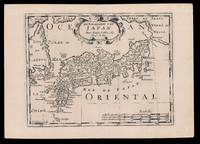
De Eilanden van Japan: Halma's Dutch edition of Sanson's map of Japan
by SANSON D'ABBEVILLE, Nicolas (I) and HALMA, Francois
- Used
- Condition
- See description
- Seller
-
London, United Kingdom
Payment Methods Accepted
About This Item
[Amsterdam,: Francois Halma,, 1705].. 221 by 311mm. (8.75 by 12.25 inches).. Engraved map. Third state of the plate, first published in Halma's pirated edition of Sanson's 'L'Asie en plvsiers cartes nouvelles, et exactes;
', as part of 'L'Europe; L'Asie; L'Amerique
en Pluiers Cartes', 1683. A direct copy of Sanson's map of 1652, the only differences being the lack of a privilege and a date in the cartouche, the addition of the signature of the engraver, Antoine de Winter in the lower left corner. This issue was published in Halma's Dutch edition, 'Algemeene Wereldbeschryving
' in 1705 and is distinguished by the change of the title from French into Dutch. Francois Halma (1653-1722) set up his printing business in Utrecht in 1674, where he issued a number of pirated maps and atlases. In this instance, since Sanson was dead, Halma may have felt that there no harm and much profit to be gained from re-printing his work. The engraver, Antoine de Winter (c1652-1700) achieved some notoriety for plagiarizing Petter Gedda's charts of the Baltic Sea, selling them on to Loots and Doncker, for inclusion in their atlases, who were subsequently sued, and ordered to surrender the plates and pay a fine of 300 florins. Sanson originally credited "Caardin [sic], Varenius" and 'others' for his map. Generally, the geography follows that of Moreira/Blancus, only a small portion of the eastern coast of Korea is shown, without stating whether it is an island or not, and there is only a hint of Hokkaido in the far northeast corner with the place name Matzumay. Varenius, or Bernhard Varen (fl1622-1650) was a German physician, geographer and natural historian. He settled in Amsterdam, and was a friend of the Blaeu family. He published 'Descriptio regni Japonia
' in 1649, and came to be known as 'the father of physical geography' (Hubbard). Sanson (1600-1667) was a French mapmaker. He supposedly began to make maps to supplement his study of history, and a map of Ancient Gaul made early in his career brought him to the attention of Cardinal Richelieu. This foothold in the French court allowed him to rise to the position of Geographe du Roi, teaching both Louis XIII and Louis XIV. Louis XIII even made him a counsellor of state. Sanson produced an atlas, 'Cartes Generales de Toutes les Parties du Monde', which contained important maps of the post roads and waterways of France. He also produced two major maps of North America: 'Amerique Septentrionale' (1650) was the first map to show the Great Lakes in a recognisable form, aided by Sanson's access to The Jesuit Relations, a collection of accounts by French missionaries to the area. The map was also drawn on a sinusoidal projection, which Sanson was the first to use. In 1656, he made 'Le Canada ou Nouvelle France', which showed the Great Lakes in greater detail, and included accurate representations of the Hudson Bay area, the Delaware and the Gulf of Saint Lawrence. After Sanson's death the business was carried on by his two surviving sons and grandson, in partnership with Hubert Jaillot. Sanson family members were revered among the foremost map makers in France for nearly a century. A leading exemplar of the French school of seventeenth-century cartography, Nicholas Sanson I is widely regarded as the founder of modern geography, and it is generally held that the so called "Great Age" of French cartography originated with his publications. Hubbard 51.3.
Reviews
(Log in or Create an Account first!)
Details
- Bookseller
- Daniel Crouch Rare Books Ltd
 (GB)
(GB)
- Bookseller's Inventory #
- 15819
- Title
- De Eilanden van Japan
- Author
- SANSON D'ABBEVILLE, Nicolas (I) and HALMA, Francois
- Book Condition
- Used
- Publisher
- Francois Halma,
- Place of Publication
- [Amsterdam,
- Date Published
- 1705].
- Keywords
- Asia, Japan
- Product_type
- Maps
- Size
- 221 by 311mm. (8.75 by 12.25 inches).
Terms of Sale
Daniel Crouch Rare Books Ltd
Any item may be returned if you are not happy with it providing we are notified within 7 days of your receiving it. This does not affect any statutory rights you may have under UK or EU law for returning the item outside this period. All we ask is that you return the item(s) by the same or similar method to that in which they were sent to you. Your postage costs and any payment already received will be refunded immediately on our receipt of the items in the same condition as you received them.
About the Seller
Daniel Crouch Rare Books Ltd
Biblio member since 2018
London
About Daniel Crouch Rare Books Ltd
Daniel Crouch Rare Books is specialist dealer in antique atlases, maps, plans, sea charts and voyages dating from the fifteenth to the nineteenth centuries. Our carefully selected stock also includes a number of fine prints and globes, and a selection of cartographic reference books.Our particular passions include rare atlases, wall maps, and separately published maps and charts. We strive to acquire unusual and quirky maps that are in fine condition. We are members of the following trade associations: The Antiquarian Bookseller's Association (ABA); The British Antique Dealers' Association (BADA); Confédération Internationale des Négociantes en Oeuvres d'Art (CINOA); The International League of Antiquarian Booksellers (ILAB); The Society of London Art Dealers (SLAD); and The European Fine Art Foundation (TEFAF). Daniel and Nick are also both members of The Company of Art Scholars, Dealers, and Collectors.
Glossary
Some terminology that may be used in this description includes:

Collect modern first editions
Biblio is showcasing the top book published every year starting in 1919. See if your favorite modern first edition made the list! Check out our collecting first editions by the year.

Beat Poet Michael McClure
From the fateful reading at Six-Gallery in 1955 to his novels, poetry, and stage productions, Michael McClure was right in the thick of the Beat Generation as it was born. See his books and art and learn more about the works of Michael McClure.
