Maps from Classic Books and Ephemera
New Arrivals
More Photos
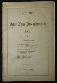
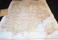
Report of the Valley Forge Park Commission 1908
- Condition
- Used - Very Good -
- Published
- 1908
- Binding
- Paperback
- Quantity Available
- 1
- Seller
-
Lansdowne, Pennsylvania, USA
- Item Price
-
NZ$87.98
Show Details
Description:
Philadelphia: James Hogan, 1908. Paperback. Very Good -. 31 p., 2 leaves of folded maps; illustrations; 24 cm. Light brown wrapper printed in dark brown; stapled. Large folded maps attached inside the front and back wrappers: Topographical Map of the Revolutionary Camp Ground at Valley Forge (1906); and General Map of the Encampment at Valley Forge Pennsylvania, 1777-8… Read more about this item Item Price
NZ$87.98
More Photos
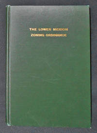
Ordinance No. 640: The Lower Merion Zoning Ordinance of 1927, As Amended; Lower Merion Township, Montgomery County, Pensylvania
- Condition
- Used - Near Fine
- Published
- 1939
- Binding
- Hardcover
- Quantity Available
- 1
- Seller
-
Lansdowne, Pennsylvania, USA
- Item Price
-
NZ$43.99
Show Details
Description:
S.l.: Lower Merion Township, 1939. Hardcover. Near Fine. Third Edition, Dec. 1939. 61 p.; 26 cm. Dark green cloth with gilt-stamped cover title. With 7 folded maps in pocket attached to back fixed endpaper; the index sheet to the zoning maps is on the back free endpaper. In Near Fine Condition: lightly cover rubbed; fore-edge of back free… Read more about this item Item Price
NZ$43.99
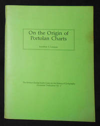
On the Origin of Portolan Charts
by Lanman, Jonathan T.
- Condition
- Used - Very Good
- Published
- 1987
- Binding
- Paperback
- ISBN
- 9780911028379
- Quantity Available
- 1
- Seller
-
Lansdowne, Pennsylvania, USA
- Item Price
-
NZ$42.30
Show Details
Description:
Chicago: The Newberry Library, 1987. Paperback. Very Good. xi, [1], 56 p.: maps, tables; 28 cm. Paperback with green cover printed in black; stapled. The Hermon Dunlap Smith Center for the History of Cartography Occasional Publication no. 2. Scarce. In Very Good Condition: cover is soiled; pages are clean and solid.
Item Price
NZ$42.30

More Photos
Atlas to Accompany Monograph XXXII on the Geology of the Yellowstone National Park
by Hague, Arnold
- Condition
- Used - Good
- Published
- 1904
- Binding
- Hardcover
- Quantity Available
- 1
- Seller
-
Lansdowne, Pennsylvania, USA
- Item Price
-
NZ$741.10
Show Details
Description:
Washington, D.C.: United States Geological Survey, 1904. Hardcover. Good. 34 leaves: 24 color maps (7 double-leaf); 56 cm. Dark brown cloth with gilt-stamped cover title. Monographs of the United States Geological Survey, v. 32. In Good Condition: cloth is soiled and rubbed; corners are frayed; minor loss at ends of spine; blank leaf preceding title page is torn… Read more about this item Item Price
NZ$741.10

Diagram Showing Points of Interest in the City of Bethlehem, Pa.; Prepared by the Bureau of City Engineer Robert L. Fox
by Fox, Robert L.
- Condition
- Used - Fine
- Published
- 1924
- Binding
- Map
- Quantity Available
- 1
- Seller
-
Lansdowne, Pennsylvania, USA
- Item Price
-
NZ$49.07
Show Details
Description:
Bethlehem, Pa: Bethlehem Chamber of Commerce, 1924. Map. Fine. 1 map (39 x 51 cm.), folded. Printed in red and black. Includes many points of interest, including Moravian sites, educational institutions, and Bethlehem Steel Co. The reverse side contains a smal map of eastern Pennsylvania showing Bethelhem's location. In Fine Condition: clean and bright.
Item Price
NZ$49.07

Baedeker Ireland
- Condition
- Used - Fine
- Published
- 1997
- Binding
- Paperback
- ISBN
- 9780028613604
- Quantity Available
- 1
- Seller
-
Lansdowne, Pennsylvania, USA
- Item Price
-
NZ$16.92
Show Details
Description:
New York: Simon & Schuster Macmillan Co, 1997. Paperback. Fine. 3rd English edition. 381 p.: color illustrations, maps; 19 cm. Paperback with illustrated cover. With: large folded map of Ireland, in back pocket of clear plastic cover. In Fine Condition: clean and tight; map is intact, clean, and bright.
Item Price
NZ$16.92
More Photos
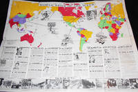
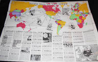
World News of the Week: Vol. 2, no. 16 -- Monday, Jan. 1, 1940
- Condition
- Used - Very Good +
- Published
- 1940
- Binding
- Map
- Quantity Available
- 1
- Seller
-
Lansdowne, Pennsylvania, USA
- Item Price
-
NZ$32.15
Show Details
Description:
Chicago: News Map of the Week, 1940. Map. Very Good +. 1 map (35 x 47 inches), folded. The upper portion is a world map in color with 33 locations marked. The lower portion provides a description of an event at each marked location. Five black-and-white cartoons are located within the map and eight black-and-white… Read more about this item Item Price
NZ$32.15
More Photos
News Map of the Week: Vol. 2, no. 6 -- Monday, Oct. 16, 1939
- Condition
- Used - Very Good
- Published
- 1939
- Binding
- Map
- Quantity Available
- 1
- Seller
-
Lansdowne, Pennsylvania, USA
- Item Price
-
NZ$25.38
Show Details
Description:
Chicago: News Map of the Week, 1939. Map. Very Good. 1 map (35 x 47 inches), folded. The upper portion is a world map in color with 38 locations marked. The lower portion provides a description of an event at each marked location. Five black-and-white cartoons are located within the map and eight black-and-white illustrations… Read more about this item Item Price
NZ$25.38

More Photos
Europe at the Time of Charles V 1519-1556 (Denoyer-Geppert New Social Science Map H9) by Samuel B. Harding; compiled and drawn by R. Baxter Blair
by Blair, R. Baxter; Harding, Samuel B.
- Condition
- Used - Very Good +
- Published
- 1956
- Binding
- Map
- Quantity Available
- 1
- Seller
-
Lansdowne, Pennsylvania, USA
- Item Price
-
NZ$148.90
Show Details
Description:
Chicago: Denoyer-Geppert Co, 1956. Map. Very Good +. 1 folded linen-backed color map (33 x 44 inches) attached to a dark green cover (30 cm.) with brown printed paper label. In Very Good+ Condition; edges are starting to fray; map is clean, bright, and intact.
Item Price
NZ$148.90
![Norfolk a Countie Florishing & Populous Desccribed and Devided with the Armes of Such Noble Familes as Have Borne the Titles Therof; Discribed by Christopher Saxton; Augmented by I. Speede [map]](https://d3525k1ryd2155.cloudfront.net/h/753/647/1175647753.0.m.jpg)
More Photos
Norfolk a Countie Florishing & Populous Desccribed and Devided with the Armes of Such Noble Familes as Have Borne the Titles Therof; Discribed by Christopher Saxton; Augmented by I. Speede [map]
by Speed, John; Elstrack, Renold
- Condition
- Used - Very Good
- Published
- 1627
- Binding
- Map
- Quantity Available
- 1
- Seller
-
Lansdowne, Pennsylvania, USA
- Item Price
-
NZ$2,179.30
Show Details
Description:
London: George Humble, 1627. Map. Very Good. "Are to be sold in popes head Alley by J. S. & G. H." "R. Elstrack sculpsit." 1 hand-colored copperplate engraving 41 x 55 cm. from Book One of John Speed's Theatre of the Empire of Great Britaine (London: George Humble, 1627). See: STC (2nd ed.), 23042. A… Read more about this item Item Price
NZ$2,179.30
More Photos
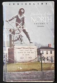
Harbors of the North Volume Two: New London, Connecticut to Jonesport, Maine
- Condition
- Used - Very Good -
- Published
- 1948
- Binding
- Paperback
- Quantity Available
- 1
- Seller
-
Lansdowne, Pennsylvania, USA
- Item Price
-
NZ$23.69
Show Details
Description:
Pittsburgh: Gulf Oil Corp, 1948. Paperback. Very Good -. Fifth Edition. [5], 134-250, [6] p., 15 loose leaves intended to be inserted at the appropriate places: maps, illustrations; 23 cm. Stapled paperback with cover illustration. This guide to harbors along the northeast coast of the United States provides "descriptions of services and products available, of… Read more about this item Item Price
NZ$23.69

More Photos
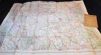
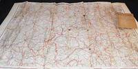
Grande Carte Routiere No. 14 bis: Des Alpes: Savoie et Haute Savoie
- Condition
- Used - Very Good -
- Published
- 1915
- Binding
- Map
- Quantity Available
- 1
- Seller
-
Lansdowne, Pennsylvania, USA
- Item Price
-
NZ$42.30
Show Details
Description:
Paris: A. Taride Editeur, 1915. Map. Very Good -. 1 folded map (75 x 53 cm.) in an envelope 19 x 13 cm. "Carte Routière pour Automobilistes & Cyclists -- Frontiere des Alpes" -- at upper edge of map. "Cartes Taride" -- at upper edge of envelope. Map in color showing roads, paths, canals, and… Read more about this item Item Price
NZ$42.30

More Photos
Grande Carte Routiere No. 32: Italie Méridionale et Sicile
- Condition
- Used - Fine
- Published
- 1910
- Binding
- Map
- Quantity Available
- 1
- Seller
-
Lansdowne, Pennsylvania, USA
- Item Price
-
NZ$49.07
Show Details
Description:
Paris: A. Taride Editeur, 1910. Map. Fine. 1 folded map (94 x 75 cm.) in an envelope 19 x 13 cm. "Cartes Taride" -- at upper edge of envelope. Map in color showing roads, paths, canals, and railroads, with captions in French and Italian. Back of envelope has map of France and adjacent territory showing… Read more about this item Item Price
NZ$49.07

More Photos
Grande Carte Routiere No. 15: Centre de la France: Section Sud-Est Auvergne et Limousin
- Condition
- Used - Very Good -
- Published
- 1915
- Binding
- Map
- Quantity Available
- 1
- Seller
-
Lansdowne, Pennsylvania, USA
- Item Price
-
NZ$43.99
Show Details
Description:
Paris: A. Taride Editeur, 1915. Map. Very Good -. 1 folded map (72 x 93 cm.) in an envelope 19 x 13 cm. "Carte Routière pour Automobilistes & Cyclists -- Centre de la France: Section Sudest" -- at upper edge of map. "Cartes Taride" -- at upper edge of envelope. Map in color showing roads,… Read more about this item Item Price
NZ$43.99
More Photos
Grande Carte Routiere No. 7: Environs de Paris Section Sud Est
- Condition
- Used - Fine
- Published
- 1915
- Binding
- Map
- Quantity Available
- 1
- Seller
-
Lansdowne, Pennsylvania, USA
- Item Price
-
NZ$49.07
Show Details
Description:
Paris: A. Taride Editeur, 1915. Map. Fine. 1 folded map (72 x 91 cm.) in an envelope 19 x 13 cm. "Carte Routière pour Automobilistes & Cyclists" -- at upper edge of map. "Cartes Taride" -- at upper edge of envelope. Map in color showing roads, paths, canals, and railroads. Back of envelope has… Read more about this item Item Price
NZ$49.07

More Photos
Grande Carte Routiere No. 8: Environs de Paris Section Sud Ouest
- Condition
- Used - Fine
- Published
- 1915
- Binding
- Map
- Quantity Available
- 1
- Seller
-
Lansdowne, Pennsylvania, USA
- Item Price
-
NZ$32.15
Show Details
Description:
Paris: A. Taride Editeur, 1915. Map. Fine. 1 folded map (72 x 91 cm.) in an envelope 19 x 13 cm. "Carte Routière pour Automobilistes & Cyclists" -- at upper edge of map. "Cartes Taride" -- on front of envelope. Map in color showing roads, paths, canals, and railroads. Back of envelope has map… Read more about this item Item Price
NZ$32.15

More Photos
Grande Carte Routiere No. 30: Italie: Section Nord
- Condition
- Used - Good -
- Published
- 1915
- Binding
- Map
- Quantity Available
- 1
- Seller
-
Lansdowne, Pennsylvania, USA
- Item Price
-
NZ$25.38
Show Details
Description:
Paris: A. Taride Editeur, 1915. Map. Good -. 1 folded map (66 x 90 cm.) in an envelope 19 x 13 cm. "Cartes Taride" -- at upper edge of envelope. Map in color showing roads, paths, canals, and railroads, with captions in French and Italian. Back of envelope has map of France and adjacent territory… Read more about this item Item Price
NZ$25.38
More Photos
Grande Carte Routiere No. 12: Centre de la France Section Ouest: Berry -- Poitou -- Touraine
- Condition
- Used - Very Good -
- Published
- 1915
- Binding
- Map
- Quantity Available
- 1
- Seller
-
Lansdowne, Pennsylvania, USA
- Item Price
-
NZ$42.30
Show Details
Description:
Paris: A. Taride Editeur, 1915. Map. Very Good -. 1 folded map (70 x 100 cm.) in an envelope 19 x 13 cm. "Carte Routière pour Automobilistes & Cyclists -- Centre de la France, Auvergne" -- at upper edge of map. "Cartes Taride" -- at upper edge of envelope. Map in color showing roads, paths,… Read more about this item Item Price
NZ$42.30
More Photos
Grande Carte Routiere No. 17: Midi de la France: Section Est Htes et Bses Alpes, Provence, Cote d'Azur
- Condition
- Used - Very Good -
- Published
- 1915
- Binding
- Map
- Quantity Available
- 1
- Seller
-
Lansdowne, Pennsylvania, USA
- Item Price
-
NZ$43.99
Show Details
Description:
Paris: A. Taride Editeur, 1915. Map. Very Good -. 1 folded map (95 x 75 cm.) in an envelope 19 x 13 cm. "Carte Routière pour Automobilistes & Cyclists -- Sud de la France, Section Est" -- at upper edge of map. "Cartes Taride" -- at upper edge of envelope. Map in color showing roads,… Read more about this item Item Price
NZ$43.99
More Photos
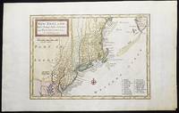
New England, New York, New Jersey, and Pensilvania &c. by H. Moll Geographer
by Moll, Herman
- Condition
- Used - Near Fine
- Published
- 1708
- Quantity Available
- 1
- Seller
-
Lansdowne, Pennsylvania, USA
- Item Price
-
NZ$785.09
Show Details
Description:
London: H. Moll, 1708. Near Fine. 1 sheet 232 x 267 mm. (image is 180 x 254 mm.) Hand-colored copper engraved map. This is Herman Moll's earliest map of New England, published in the first edition of John Oldmixon's The British Empire in North America in 1708. List of 19 towns in lower right-hand… Read more about this item Item Price
NZ$785.09
