Skip to content

Search Results: Authors starting with C from BICKERSTAFF'S BOOKS, MAPS &C.

You searched for:
  • Bookseller inventory: BICKERSTAFF'S BOOKS, MAPS &C. (authors starting with C)
  • Bookseller: BICKERSTAFF'S BOOKS, MAPS &C.
Results 1 - 2 of 2
Chart of Portland Harbour and Islands, and Harbours Adjacent, Extending from the River Kennebec...
More Photos

Chart of Portland Harbour and Islands, and Harbours Adjacent, Extending from the River Kennebec to Wood Island and Winter Harbour, Drawn from the Survey of Des Barres with Additions and Corrections by L. Moody.

by [Casco Bay, Maine] [Nautical Chart.] Moody, Lemuel.

  • Used
Condition
Used
Quantity Available
1
Seller
Scarborough, Maine, United States
Seller rating:
This seller has earned a 5 of 5 Stars rating from Biblio customers.
Item Price
NZ$18,724.20
NZ$17.02 shipping to USA

Show Details

Description:
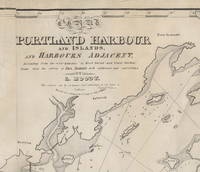
Important Early Chart of Portland (Maine) Harbor
Lemuel Moody (1767-1846) was an enterprising sea captain and nautical entrepreneur in Portland, Maine. Realizing "the great necessity of a correct Chart of Portland Harbour and the dangerous Rocks near Cape Elizabeth, also of Winter Harbour and the numerous islands in Casco Bay," Moody decided to produce such a chart. By 1825, the Atlantic Neptune charts that included this area were more than 50 years old and in need of updating. Moody took advantage of the opportunity and produced this chart, using the Atlantic Neptune charts as the foundation. In a notation on the original agreement for producing the chart, Moody states that "I did the whole of the survey." This impressive chart of Casco Bay was his sole cartographic undertaking.
The chart covers the area from Saco Bay to Seguin Island. A large inset at the upper left focuses on the immediate area around Portland harbor, including a detailed layout of streets and wharves. Small drawings of… Read More
Item Price
NZ$18,724.20
NZ$17.02 shipping to USA
A Plan of Charles Town the Capital of South Carolina, with the Harbour, Islands and Forts; the...
More Photos

A Plan of Charles Town the Capital of South Carolina, with the Harbour, Islands and Forts; the Attack on Fort Sulivan [sic] by His Majesty's Ships under Sir Peter Parker, in 1776; ...: the Position of the Landed Forces, under General Clinton, and the Rebel Camp and Intrenchments, exactly delineate

by [Charleston, SC.] [American Revolution.]

  • Used
  • very good
Condition
Used - Very Good
Quantity Available
1
Seller
Scarborough, Maine, United States
Seller rating:
This seller has earned a 5 of 5 Stars rating from Biblio customers.
Item Price
NZ$2,042.64
NZ$17.02 shipping to USA

Show Details

Description:
A small but informative map depicting the British attack on Fort Sullivan in Charleston harbor in late June, 1776. Five ships are shown attacking the Fort. Rebel camps, ships and intrenchments are also shown. Jolly, Maps of America in Periodicals before 1800: 340. Nebenzahl, A Bibliography of Printed Battle Plans of the American Revolution 1775-1795: 70.
Item Price
NZ$2,042.64
NZ$17.02 shipping to USA
Add to Want List

Didn’t find what you’re looking for?

Try adding this search to your want list. Millions of books are added to our site everyday and when we find one that matches your search, we’ll send you an email. Best of all, it’s free.

Add to Want List
Book lovers can save on books by joining our Bibliophiles club

Are you a frequent reader or book collector?

Join the Bibliophile's Club and save 10% on every purchase, every day — up to $20 savings per order!

Biblio is a socially responsible company

Social Responsibility

Did you know that since 2004, Biblio has used its profits to build 16 public libraries in rural villages of South America?